CSEC GEOGRAPHY PAPER 1- 2017
•
3 likes•2,192 views

This document contains instructions for a geography exam consisting of 60 multiple choice items. Test takers have 1 hour and 15 minutes to complete the exam. They should mark their answers on an answer sheet using letters A-D. Sample questions and instructions are provided to demonstrate how to mark answers. The test will contain questions referring to maps, diagrams, graphs and statements requiring analysis and choice of the best answer.

Recommended
Recommended
More Related Content
What's hot
What's hot (20)
Similar to CSEC GEOGRAPHY PAPER 1- 2017
Similar to CSEC GEOGRAPHY PAPER 1- 2017 (20)
More from Oral Johnson
More from Oral Johnson (20)
Recently uploaded
Recently uploaded (20)
CSEC GEOGRAPHY PAPER 1- 2017
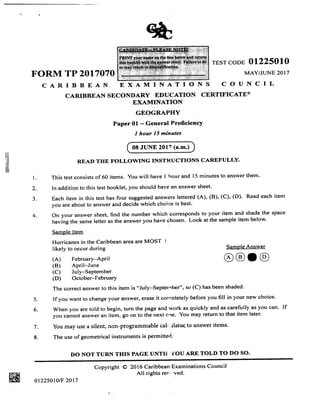
- 1. B.& TEST CODE OI225OIO FORM TP 2017070 MAY/JUNE 2OI7 CARIBBEAN EXAMINATIONS COUNCIL CARIBBEAN SECONDARY EDU.CATION CERTIFICATE@ EXAMINATION GEOGRAPHY Paper 01 - General ProficiencY I hour 15 minutes READ THE FOLLOWING INSTRUCTIONS CAREFULLY. This test consists of 60 items. You will have I hour and I 5 minutes to answer them. In addition to this test booklet, you should have an answer sheet. Each item in this test has four suggested answers lettered (A), (B), (C), (D). Read each item you are about to answer and decide which choice is best' On your answer sheet, find the number which corresponds to your item and shade the space having the same letter as the answer you have chosen. Look at the sample item below' Samole Item Hurricanes in the Caribbean area are MOST I likely to occur during Sample Answer (A) February-APril (B) April-June (C) July-September (D) October-February The correct answer to this item is "July-Septernber", so (C) has been shaded. 5. If you want to change your answer, erase it cornpletely before you fill in your new choice. 6. When you are told to begin, turn the page and work as quickly and as carefully as you can. If you cannot answer an item, go on to the next o,ne. You may return to that item later. 7. You may use a silent, non-programmable calc ':lato(to answer items. 8. The use of geometrical instruments is permitted' DO NOT TURI{ THIS PAGE UNTIX YOU ARE TOLD TO DO SO. 2. 3. 4. o 08 JUNE 2017 (a.m.) Copyright @ 2016 Caribbean Examinations Council All rights res'' 'ved. ffiE ot2250l0lF 2017 @
- 2. -2- Items 1-8 refer to the following map showing some rslands of the Eastern Caribbean. Five islands are labelled I, II, III, IV and V. 640 600 lEo q at7<,O Virgin )4st Martln Islands E' oSaba Eustatiuss S Barbuda { CF Galante I CARIBBEAN SEA ,4 t% o% -v '*(l ru-*Q g. o o c a Grenadines D* IV bBarbados A 9-r oQ Vene I S zuela a ? v 640 620 N + 600 0 50 100 mlles 0 E0 160 kilometres 160 620 140 12" 100 1E" 16" 140 120 10" ot2250to/F 2017 GO ON TO THE NEXT PAGE
- 3. -J- 5. .t I In which direction should an airplane fly on leaving Marie-Galante to go to Saba? (A) Northeast (B) Southeast (C) Southwest (D) Northwest The grid bearing of Sint Eustatius from Marie-Galante is St Martin is located on the line of latitude that is approximately (A) l8"N (B) l8"S (c) 63"8 (D) 63. W The straight-line distance, in kilometres, between Saba and Marie-Galante is approximately 62 (A) (B) (c) (D) (A) (B) (c) (D) (A) (B) (c) (D) 045" I 35" 225" 3 15. l4oN,6l"E l4oN,6l.W 61"N, l4"W 6l oN, 140 E Antigua Grenada Dominica Saint Lucia (A) (B) (c) (D) t75 240 280 320 3 What is the location of the island labelled II? To which of the following groups do the islands labelled lt, III and IV belong? (A) Greater Antilles (B) Leeward Antilles (C) Leeward lslands (D) Windward Islands The island labelled V is closest to which of the following regions? (A) North America (B) South America (C) Central America (D) Western America 4. The name of the island labelled I is l 8 0t2250tolF 20t7 HI CO ON TO THE NEXT PAGE 7.
- 4. -4- I@2refers to the following diagram oi a river. 9. In what general direction is the river flou ing? (A) East to West (B) North to South (C) Southeast to Northwest (D) Southwest to Northeast N t 10. Which of the following phrases refers to Eastings? (A) Vertical lines that decrease in value eastwards (B) Vertical lines that increase in value eastwards (C) Horizontal lines that increase in nalue northwards (D) Horizontal tines that decrease in value northwards ot2250to/F 2017 GO ON TO THE NEXT PAGE
- 5. 5 Items 11-12 refer to the following map extract of the Black River area, Jamaica 42 4l 11. The feature labelled X(at257412) is a (A) confluence (B) distributary (C) river capture (D) deferred junction 12. The general direction of flow of the Black River is 4325 25 (A) SE (B) NE (c) NNE (D) SSw 0tzzsol0/F 2017 --r" -+-Jtr + +. + .lll E * -Le ,+ 4r 4r .. ,4 ,$: +. 4r + .+- - .t ,} Luril- +' <5 i-. ..r /L i.. * t.t ,t5 -Il * .{L rI! - - 4lr x R.A.S -.+i-.{:-4ts .Ua-.*-&- f - 41.- * ,*. {i--- -+.-ler 4! BLACK. FIVER. . BAY -,. -;. : -, ', ...t ". Cr- -& - & 4L trffi CO ON TO THE NEXT PACE 4L- .4. -t .tr
- 6. -6 Item 13 refers to the following graph which shows the percentage of the total population employed in agriculture in 1950 and 2000 in som,: Caribbean territories. l@x r9so @B 2000 The Bahamas Barbados Cuba Dominican Republic Guadeloupe Haiti Jamaica Martinique Puerto Rico Trinidad and Tobago 0 l0 20 30 40 50 60 70 E0 90 ("/" 13. Which country had the LARGEST percentage decline in people employed in agriculture? (A) Haiti (B) Maninique (C) Trinidad and Tobago (D) Dominican Republic I 14. A relationship between longitude and time is that the time changes by (A) (B) (c) (D) I hour for 20" I minute for 4" 4 minutes for I " 24 hours for I 80" 15. The factor explaining the difference between weather and climate is (A) time (B) rainfall (C) location (D) temperature 01225010/F 2017 GO ON TO THE NEXT PAGE
- 7. -7 - 16. Atravellermadethefollowingobservations. "lt was hot and rained heavily every day; the trees grew very tall and there was little undergrowth." Which of the following forest vegetation types was the traveller describing? Items I &-1 9 refer to the fol lowingdiagram. N 18. The feature at M is a (A) (B) (c) (D) t7 Item 17 refers to the following statement. "The temperature sudden ly drops and wind speed increases; the sky gradually becomes overcast and there is a slight drizzle." What type of weather system is being described? Montane Equatorial Deciduous Semi-evergreen Cold front Hurricane Tropical wave Intertropical Convergence Zone Which of the following features forms in the area marked N? t9 (A) (B) (c) (D) (A) (B) (c) (D) lev6e terrace waterfall flood plain A lev6e A plateau A flood plain An alluvial fan (A) (B) (c) (D) ol2250lolF 2017 ffi GO ON TO THE NEXT PAGE
- 8. KEY atr Bulldings .t:t"i:t+, Sand Contours V.I40 m m40 I I I wa-rr rr a Centre -8- Items 20-21 refer to the following map. Scale: 2 cm:l km 20. The features found at T on the map are 21. (A) a bay and beach (B) a headland and bay (C) cliffs and coral reefs (D) a beach and headland x 1: 50 000 A contour sketch from Point R to Point X would look like Height (A) (m) 120 R Distance x Y (B) Height (m) Height (m) 120, 80 I Height 80 40 (m) 120 80 40 0 (c) R Distance Distance x xR (D) R Distance x o1225010/F 2017 GO ON TO THE NEXT PAGE
- 9. Y -9- Items22-2,6 refer to the following diagram of a Caribbean weather system 22. The line labelled X rePresents (A) a trough (B) an isobar (C) a tropical wave (D) thelntertropicalConvergenceZone (tTCZ) 23. The line labelled Y rePresents The rainfall depicted by the station model behind the line X can BEST be described as 25 (A) (B) (c) (D) an isobar a cold front a warm front a tropical wave 26. a', (A) (B) (c) (D) (A) (B) (c) (D) (A) sills (B) dykes (C) laccoliths (D) lava flows The c loud cover shown on the station model behind the line X can BEST be described as drizzle light rainfall heavy rainfall intermittent showers high and clear low and clear high and totally overcast low and totally overcast24 The station model behind the line X shows the wind blowing from the (A) northwest at 15 knots (B) southeast at I 5 knots (C) northwest at 20 knots (D) southeast at 20 knots ot2250lo/F 2017 When magma emerges on the surface, it may lead to the formation of ffi GO ON TO THE NEXT PAGE
- 10. - l0- 28. 29 Which of the following weather systems does NOT affect the Caribbean during thc summer in the northern hemisphere? (A) Cold fronts . (B) Anticyclones (C) Easterly/Tropical waves (D) The Intertropical Conveipen. e' Zone (ITCZ) As one climbs a mountain, the surrounding temperature (A) decreases (B) increases (C) fluctuates (D) remains constant How does vegetation contribute to the development of soils? (A) It provides the parent material. (B) It decomposes to form humus. (C) It increases the depth of soil. (D) Itdecomposestoproduceinorganic matter. The slow downhill movement of debris and soil underthe influence of gravity may BEST be described as landslide soil creep soil erosion mass wasting 30. 31 (A) (B) (c) (D) Items 32-33 refer to the following popul,rtion density map of Island P I Inhabitants per km2 N KEY Im > 400 20v399 100-199 0-99 POPULITION DENSITY OF ISLAID P 32. Which of the following statements is true? 33 (A) Thepopulationisevenlydistributed. (B) The area of highest density is in the south. (C) The population density increases outward from Area l. (D) The population density decrease3, outward from Area I. Which of the following areas has the SMALLEST population? (A) I (B) rr (c) rrr (D) rv ot2250to/F 20t7 GO ON TO THE NEXT PAGE
- 11. - ll - O o E o GI q o o o c) N U) Items 34-35 refer to the following graph showing the population size of a country for the years 1850 to 2025. 1 1900 1950 2000 2050 Years In which of the following periods was the population growth constant? (A) l8s0-r e00 (B) 1900-te2s (c) tg2s-teso (D) teso-197s What was the approximate size of the population in the year 2OOO? 4 I 3 2 3s. 36 (A) (B) (c) (D) (A) (B) (c) (D) Which of the following phrases defines exfoliation? r s00 000 2 000 000 2 500 000 3 000 000 Peeling off of the outer layers of rocks Splitting of rocks into rectangular blocks Movement ofrocks due to the action of rivers Disintegration of rocks by root penetration into crevices 34. Item 37 refers to the following diagram of the hydrologic cycle. 37. In the diagram, X represents (A) percolation (B) evaporation (C) transpiration (D) precipitation o12250t0/F 2017 I Sea I irl Rainfall x flffi GO ON TO THE NEXT PAGE <- ll rt )
- 12. ''-12- 38 39 Item 38 refers to the following diagram. Thibuteries Rive. The diagram shows a mountain with tributaries leading to a river which flows into the sea. The dotted line represents - (A) a plateau ' (B) the hilltop (C) the watershed (D) the drainage basin Rapid urbanization in Caribb""n "ouplriesUSUALLY results in Which of the following features is an example of intrusive vulcanicity? (A) Sill (B) Crater (C) Caldera (D) Lava plateau Item 42 refers to the following diagram of a coastal area. Which ofthe following processes is MOST likely to result in the formation ofthe feature x? 4l 42 43 I. II. III. (A) (B) (c) (D) (A) (B) (c) (D) (A) (B) (c) (D) housing shortages in the cities 'l increased employment in the cities decreased foreign exchange earnings an improvement in the standard of living Longshore drift Wave erosion Wave deposition I and II only I and III only II and III only I, II and lll Altitude Latitude Rainfall Humidity 40. Deposition by a river usually occurs when its Which of the following is MAINLY responsible for high temperatures in the Caribbean?(A) (B) (c) (D) volume increases gradient increases velocity decreases channel roughness decreases -d I xa'l! Sea Sea 012250101F 2017 GO ON TO THE NEXT PACE
- 13. -13- 44 Which ofthe following types ofsettlements will MOST likely develop along a main road? Which of the following is NOT a problem affecting industrial development in the Caribbean? 49 (A) (B) (c) (D) 45. 46. 47 (A) (B) (c) (D) 48. (A) (B) (c) (D) 0122501o/F 20t7 Which ofthe following is considered apoor farming practice? (A) Tillage (B) Overgrazing (C) Strip cropping (D) Contour ploughing ln peasant farming in the Caribbean, the maintenance of the organic content in the soils can be ensured by the (A) rotation of crops (B) burning of vegetation (C) application of manures (D) use of chemical fertilizers What word is used to describe that part of a river's course which is wide and shallow and has bars and islands around which the river flows? Which of the following measures do governments use to influence the location of industries? lnadequate capital lnadequate markets Limited raw materials A large labour force Provision of tax incentives Offer of training programmes to employees Provision of the physical infrastructure I and II only I and lll only II and III only I, II and III Discharge of chemicals in the sea Discharge of fish waste in the sea Discharge of exhaust fumes from motor vehicles Accumulation of garbage from factories Linear lsolated Dispersed Nucleated Braided Flooded Turbulent Meandering solution refraction longshore drift hydraulic action 50 5l 52 (A) (B) (c) (D) II. TII (A) (B) (c) (D) (A) (B) (c) (D) Which of the following features is typical of large-scale commercial farming? (A) Small acreage (B) Multi-crop system (C) Large labour force (D) lntensive mechanization Which of the following situations contributes MOST to pollution of the environmentofcapital cities in CARICOM countries? The process by which beach material is moved along the coast by wave action is called ffi GO ON TO THE NEXT PAGE
- 14. -14- 53. Which of the following statements aboufrsoil is generally true? (A) The depth increases as moisture content increases. (B) The acidity increases as the humus content decreases. (C) The fertility increases as the humrrs content increases. (D) The acidity increases as the moisr.ure content decreases Item 54 refers to the following map. 54. In which of the following areas on the map would early settlers MOST likely have chosen to build a town? (A) (B) (c) (D) 55. Which of the following factors is the MOST important contributor to the growth of capital cities in the Caribbean? w x Y Z (A) (B) (c) (D) 56. (A) (B) (c) (D) Availability of housing Availabil ity of services I nternational m igration Changes in the urban boundarieS Tourism Petroleum Agriculture Manufacturing What is the leading foreign exchange earner in MOST Caribbean countries? .x !z 00^ Key Swamp Contour llnes .z t JSS ass tss Y Sea oW iz !k Jz iz v,L/ llt ik 0122501o/F 2017 GO ON TO THE NEXT PAGE
- 15. - 15 - Items 57-58 ref'er to the fbllowing diagram shorving a series of consequences from tropical deforestation. Tropical Deforestation Great Overland Flow Soil Erosion 59Which ofthe following consequences BEST represents X? (A) Flooding (B) Reduced rainfall (C) Decreased canopy (D) Reduced soil fertility What other consequence can result from trop ical deforestation? (A) Lumbering (B) Loss of flora (C) lncrease in fauna (D) Increase in underground water --) x Which of the following are COMMON causes ofcoastal pollution inthe Caribbean? Oil spi lls from ocean-going vessels Poisonous fumes from industrial plants Discharge of waste material into rivers --) _> 57 I. II III 58 (A) (B) (c) (D) II III (A) (B) (c) (D) I and II only I and III only II and III only I, II and lll Increased useofch lorofl uorocarbons (CFCs) lncreased use of solar power Reduction in the use of fossil fuels I and II only I and III only II and lll only I, II and III 60 Which ofthe following actions can be used to reduce the emission ofgreenhouse gases? I END OF TEST IF YOU FINISH BEFORE TIME IS CALLED, CHECK YOUR WORK ON THIS TEST. ffi 0122501o/F 2017