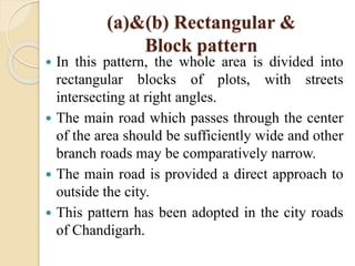
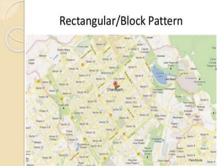
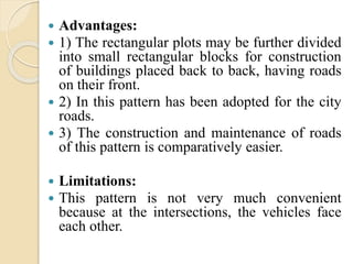
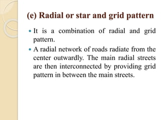
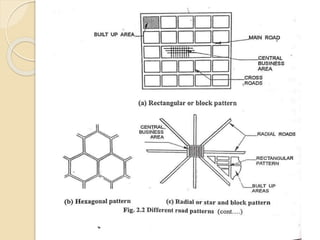
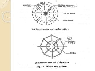
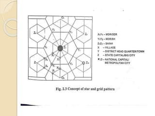
2. Classification of Roads
Types of roads
The roads are generally classified into two
categories, depending on whether they can
be used during different seasons of the year:
(i) All-weather roads and
(ii) Fair-weather roads
3. All-weather roads are those which are
negotiable during all seasons of the year,
except at major river crossings where some
interruption to traffic is permissible up to a
certain extent, but the road pavement should
be negotiable during all weathers.
On 'fair weather roads' the traffic may be
interrupted during monsoon season at
causeways where streams may overflow
across the road.
4. Based on the type of the carriageway or the
road pavement, the roads are classified
as`paved roads' and `un-paved roads'.
The roads with a hard pavement surface on
the carriageway are called 'paved roads'.
The roads without a hard pavement surface
on the carriageway are called 'unpaved
roads'.
Earth roads and gravel roads may be called
unpaved roads.
5. Based on the type of pavement surfacing
provided, the roads may be classified as
`surfaced roads' and `un-surfaced roads'.
Road pavements with any type of bituminous
surface or cement concrete are called
surfaced roads.
The roads which are not provided with a
bituminous or cement concrete surfacing are
called un-surfaced roads.
6. Methods of classification of roads
The roads are generally classified based on
the following:
(a) Traffic volume
(b) Load transported or tonnage
(c) Location and function
7. The classification based on traffic volume or
tonnage has been arbitrarily fixed by different
agencies and there may not be a common
agreement regarding the limits for each of
classification group. Based on the traffic volume
or flow, the roads are classified as heavy,
medium and low volume roads.
These terms are relative and so the limits under
each class should be clearly defined and
expressed as vehicles per day or 'annual average
daily traffic', etc.
Likewise the classification based on load or
tonnage is also relative and the roads may be
classified as class L II etc. or class A, B etc. and
the limits may be expressed in terms of tones per
day.
8. The classification based on location and
function should therefore be a more
acceptable classification method for a
country as they may be defined clearly.
9. Road classification based on
location and function
Road classification as per Nagpur road
plan:
The Nagpur Road Plan classified the roads in
India based on location and function into
following five categories and described
below:
(i) National Highways (NH)
(ii) State Highways (SH)
(iii)Major District Roads (MDR)
(iv) Other District Roads (ODR) and
(v) Village Roads (VR)
10. (i) National Highways (NH)
National Highways (NH) are main highways
running through the length and breadth of
India, connecting major ports, foreign
highways, capitals of large states and large
industrial and tourist centres including roads
required for strategic movements for the
defence of India.
11. All the national highways are assigned the
respective numbers.
For example, NH-1 is the national
highway connecting Delhi, Ambala,
Jalandhar and Amritsar (up to Pakistan
border);
NH-4 connects Thane, Pune, Belgaum,
Hubli, Bangalore, Chittoor and Chennai.
12. (ii)State Highways (SH)
State Highways (SH) are arterial roads of a
state, connecting the national highways of
adjacent state, district head quarters and
important cities within the state and serve as
the main arteries for traffic to and from
district roads.
These highways are considered as main
arteries of commerce by road within a state
or a similar geographical unit.
13. (iii) Major District Roads (MDR)
Major District Roads (MDR) are important
roads within a district serving areas of
production and markets and connecting with
other major roads or main highways of a
district.
The MDR has lower speed and geometric
design specifications than NH/SH.
14. (iv) Other District Roads (ODR)
Other District Roads (ODR) are roads
serving rural areas of production and
providing them with outlet to market centres,
taluk head quarters, block development head
quarters or other main roads.
These are of lower design specifications than
MDR.
15. (v) Village Roads (VR)
Village Roads (VR) are roads connecting
villages or groups of villages with each other
to the nearest road of a higher category.
It was specified that these village roads
should be in essence farm tracks, but it was
desired that the prevalent practice of leaving
such tracks to develop and maintain by
themselves should be replaced by a plan for
a designed and regulated system.
16. Road classification as per third 20-year
road development plan, 1981 - 2001
The road classification system was modified
in the third 20-year road development plan.
The roads in the country are now classified
into three classes, for the purpose of
transport planning, functional identification,
earmarking administrative jurisdictions and
assigning priorities on a road net work.
(i) Primary system
(ii) Secondary system and
(iii) Tertiary system or rural roads
17. Primary system consists of two categories
of highways:
(a) Expressways and
(b) National Highways (NH)
18. (i) Expressways
Expressways are a separate class of
highways with, Superior facilities and design
standards and are meant as through routes
having very high volume of traffic.
The expressways are to be provided with
divided carriageways, controlled access,
grade separations at cross roads and fencing.
These highways should permit only fast
moving vehicles.
19. Expressways may be owned by the Central
Government or a State Government,
depending on whether the route is a National
Highway or State Highway.
(ii) The National Highways form the other
main category of primary system in the
country.
20. The Secondary system consists of two
categories of roads:
(a) State Highways (SH) and
(b) Major District Roads (MDR)
The Tertiary systems are rural roads and
these consist of two categories of roads:
(a) Other District Road (ODR)
(b) Village Roads (VR)
The definitions of NH, SH, MDR, ODR and
VR are the same as given under classification
of roads by Nagpur Road Plan.
21. Classification of urban roads
The road systems within urban areas are
classified as Urban Roads and will form a
separate category of roads to be taken care
by the respective urban authorities.
The lengths of urban roads are not included
in the targets of the Third Twenty Year Road
Development Plan 1981-2001.
22. The urban roads are classified as:
(a) Arterial roads
(b) Sub-arterial roads
(c) Collector streets and
(d) Local streets
23. Arterials and sub-arterials are urban roads
primarily for through traffic on a continuous
route, but the sub-arterials have a lower level
of traffic mobility than the arterials.
Collector streets provide access to arterial
roads and they collect and distribute traffic
from and to local streets which provide
access to abutting property.
24. Road Patterns
The various road Patterns may be
classified as follows:
(a) Rectangular or block pattern
(b) Radial or star and block pattern
(c) Hexagonal pattern
(d) Radial or star and circular pattern
(e) Radial or star and grid pattern
25. (a)&(b) Rectangular &
Block pattern
In this pattern, the whole area is divided into
rectangular blocks of plots, with streets
intersecting at right angles.
The main road which passes through the center
of the area should be sufficiently wide and other
branch roads may be comparatively narrow.
The main road is provided a direct approach to
outside the city.
This pattern has been adopted in the city roads
of Chandigarh.
26.
27. Advantages:
1) The rectangular plots may be further divided
into small rectangular blocks for construction
of buildings placed back to back, having roads
on their front.
2) In this pattern has been adopted for the city
roads.
3) The construction and maintenance of roads
of this pattern is comparatively easier.
Limitations:
This pattern is not very much convenient
because at the intersections, the vehicles face
each other.
28. (c) Hexagonal pattern
This pattern is a network of roads that
grow in such a manner in various
directions forming hexagons.
29. (d) Radial or star and circular
pattern
In this pattern, the entire area is divided
into a network of roads radiating from the
business outwardly.
In between radiating main roads, the built-
up area may be planned with rectangular
block.
30.
31. Advantage:
1) Reduces level of congestion at the primary
bottleneck location.
2) Prevents traffic from accessing local flow
routes in the direction of the event venue that
operate in favor of egress traffic flow.
3) If one is block then other side traffic can
move.
Limitations:
1) Proves particularly effective if two-lane
ramp traffic does not have to merge at
downstream end of ramp.
32. (e) Radial or star and grid pattern
It is a combination of radial and grid
pattern.
A radial network of roads radiate from the
center outwardly. The main radial streets
are then interconnected by providing grid
pattern in between the main streets.