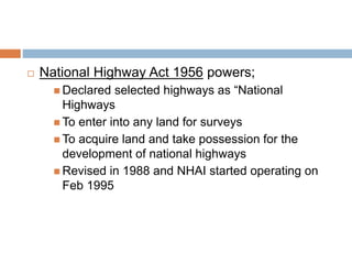
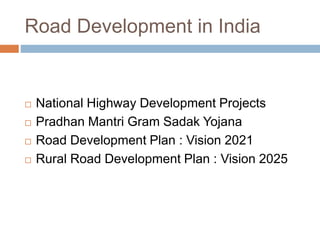
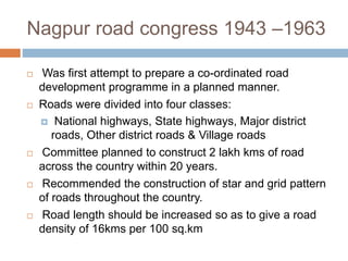
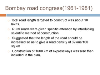
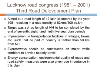
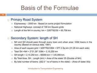
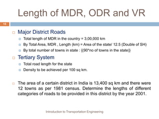
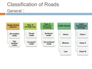
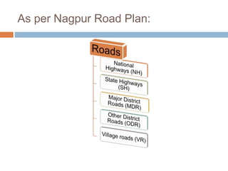
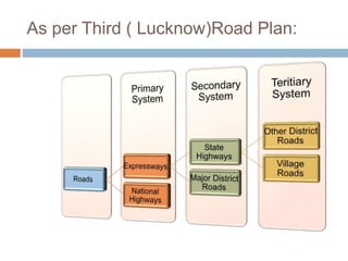
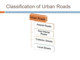
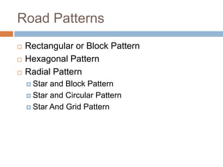
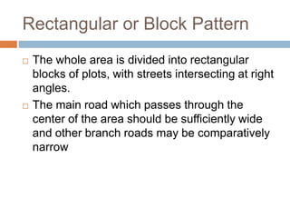
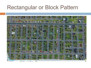
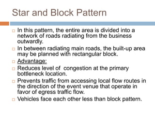
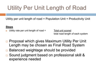
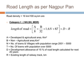
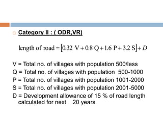
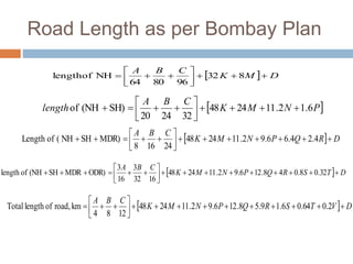
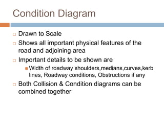
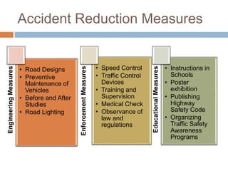
SlideShare a Scribd company logo
1 of 49
INTRODUCTION TO HIGHWAY
ENGINEERING
TE/BE/2016-2017 Part I
ROLE OF TRANSPORTATION
 Economic role of transportation
 Place, time, quality and utility of goods
 Changes in location of activities
 Social role of transportation
 Formation of settlements
 Size and pattern of settlements
 Growth of urban centers
 Political role of transportation
 Administration of an area
 Political choices in transport
 Environmental role of transportation
 Safety
 Air Pollution
 Noise pollution
 Energy consumption
 Other impacts
 Land use
 Aesthetics of a region
 Relocation of residents
SCOPE OF TRANSPORTATION
 Development,Planning & Locations
 Highway design, Geometrics & Structures
 Traffic Performance & its control
 Materials, construction & Maintenance
 Economics, Finance & Administration
History of Roads in India
 Ancient civilizations
 existence of planned roads in India as old as 2500-3500 BC
 Mauryan period(Arthashastra written by Kautilya)
 contained rules for regulations for traffic, depths of roads for
various purposes, and punishments for obstructing traffic
 Mughal period
 Roads linked North-West and the Eastern areas through
gangetic plains
 British period
 Grand-Trunk road connecting North and South
 Neglect the road system in India
 Military and administrative purpose only
 Introduction of railways
 Feeder roads to the railways
5
Cross Section of Early Roads
Introduction to Transportation Engineering
6
Telford Pavement
Macadam Pavement
Jayakar Committee (1927)
 Central government should take the proper charge from
local governments
 Gave more stress on long term planning programme,
for a period of 20 years (hence called twenty year plan)
 One of the recommendations paved the way for the
establishment of a semi-social technical body called
Indian Road Congress (IRC) (HRB) in 1934
 The committee suggested imposition of additional
taxation on motor transport which includes duty on
motor spirit, vehicle taxation, license fees for vehicles
plying for hire, called Central road fund in 1929
 Central Road Research Institute (CRRI),dedicated
research organization was constituted to carry out
research in 1950
 Central Road Fund 1929
 Extra levy of 2.64 paisa per litre
 20 % as Central reserve & 80 % is alloted for
development
 Now,revised cess is Rs.2/- per litre of petrol and
HSD
 Motor Vehicle Act 1939
 Control of drivers
 Vehicle ownership
 Vehicle operations on roads & traffic streams
 Revised in 1988
 National Highway Act 1956 powers;
 Declared selected highways as “National
Highways
 To enter into any land for surveys
 To acquire land and take possession for the
development of national highways
 Revised in 1988 and NHAI started operating on
Feb 1995
Road Development in India
 National Highway Development Projects
 Pradhan Mantri Gram Sadak Yojana
 Road Development Plan : Vision 2021
 Rural Road Development Plan : Vision 2025
Nagpur road congress 1943 –1963
 Was first attempt to prepare a co-ordinated road
development programme in a planned manner.
 Roads were divided into four classes:
 National highways, State highways, Major district
roads, Other district roads & Village roads
 Committee planned to construct 2 lakh kms of road
across the country within 20 years.
 Recommended the construction of star and grid pattern
of roads throughout the country.
 Road length should be increased so as to give a road
density of 16kms per 100 sq.km
Bombay road congress(1961-1981)
 Total road length targeted to construct was about 10
lakhs.
 Rural roads were given specific attention by introducing
scientific method of construction
 Suggested that the length of the road should be
increased so as to give a road density of 32kms/100
sq.km
 Construction of 1600 km of expressways was also then
included in the plan.
Lucknow road congress (1981 – 2001)
Third Road Delevopment Plan
 Aimed at a road length of 12 lakh kilometres by the year
1981 resulting in a road density of 82kms/100 sq.km
 Target was set as length of NH to be completed by the
end of seventh, eighth and ninth five year plan periods
 Improvement in transportation facilities in villages, towns
etc. such that no part of country is farther than 50 km
from NH
 Expressways should be constructed on major traffic
corridors to provide speedy travel
 Energy conservation, environmental quality of roads and
road safety measures were also given due importance in
this plan
Basis of the Formulae
 Primary Road System
 Expressway – 2000 km : Based on some project formulation
 National Highways: concept of 100 km Square grids
 Length of the NH in country, km = 3287782/50 = 65,756 km
 Secondary System: length of SH
 NH and SH should pass through every town and urban area: 3364 towns in the
country (Based on census data: 1981)
 Area of each square grid = 3287782/3364 = 977.3 Sq km (31.26 km each side)
 Total SH +NH = 2*31.26* 3364 = 2,10,250 km
 SH length = 2,10,250 km – 66000 km = 1,45,000 km.
 By Total Area, SH , Length (km) = Area of the state/ 25 (Double of NH)
 By total number of towns: {(62.5 * no of towns in the state) – (Area of state/ 50)}
Introduction to Transportation Engineering
14
Length of MDR, ODR and VR
 Major District Roads
 Total length of MDR in the country = 3,00,000 km
 By Total Area, MDR , Length (km) = Area of the state/ 12.5 (Double of SH)
 By total number of towns in state : {(90*no of towns in the state)}
 Tertiary System
 Total road length for the state
 Density to be achieved per 100 sq km.
 The area of a certain district in India is 13,400 sq km and there were
12 towns as per 1981 census. Determine the lengths of different
categories of roads to be provided in this district by the year 2001.
Introduction to Transportation Engineering
15
Classification of Roads
General :
Usage during
seasons
All weather
roads
Fair
weather
roads
Type of
carriage way
Paved
roads
Un paved
roads
Type of
pavement
surfacing
Surfaced
roads
Un-surfaced
roads
Traffic Volume
Heavy
Medium
Low
Load
Transported
/tonnage
Class I
Class II
Class III
As per Nagpur Road Plan:
As per Third ( Lucknow)Road Plan:
Classification of Urban Roads
Road Patterns
 Rectangular or Block Pattern
 Hexagonal Pattern
 Radial Pattern
 Star and Block Pattern
 Star and Circular Pattern
 Star And Grid Pattern
Rectangular or Block Pattern
 The whole area is divided into rectangular
blocks of plots, with streets intersecting at right
angles.
 The main road which passes through the
center of the area should be sufficiently wide
and other branch roads may be comparatively
narrow
Rectangular or Block Pattern
 Advantages:
 The rectangular plots may be further divided into small
rectangular blocks for construction of buildings placed
back to back, having roads on their front.
 In this pattern has been adopted for the city roads.
 The construction and maintenance of roads of this
pattern is comparatively easier.
 The main road is provided a direct approach to
outside the city
 Limitations:
 This pattern is not very much convenient because at
the intersections, the vehicles face each other.
Rectangular or Block Pattern
Hexagonal Pattern
Star and Block Pattern
 In this pattern, the entire area is divided into a
network of roads radiating from the business
outwardly.
 In between radiating main roads, the built-up area
may be planned with rectangular block.
 Advantage:
 Reduces level of congestion at the primary
bottleneck location.
 Prevents traffic from accessing local flow routes in
the direction of the event venue that operate in
favor of egress traffic flow.
 Vehicles face each other less than block pattern.
Star and Circular Pattern
 In this system, the main radial roads radiating
from central business area are connected
together with concentric roads.
 In these areas, boundary by adjacent radial
roads and corresponding circular roads, the
built-up area is planned with a curved block
system
Star and Circular Pattern
Star and Grid Pattern
 Advantages:
 Keep vehicular traffic safe.
 Improve traffic flow in both directions using cellular
structure.
 Improve land use efficiency and unit density.
 Limitations:
 Islands separating the approach and exit lanes,
known as splitter islands, should extend far enough.
 Examples:
 The Nagpur road plan formulae were prepared on the
assumption of Grid pattern.
PLANNING SURVEYS
 Fact finding studies carried out in a scientific
manner
 Studies included are
 Economic studies
 Financial studies
 Traffic studies
 Engineering studies
Data collected are:
EconomicStudies
• Existing road
facility
• Estimated
cost
• Total
population
and classified
distribution
• Per capita
income
• Development
& future
trends
FinancialStudies
• Source of
income &
estimated
revenue from
taxes
• Standard of
living
• Resource at
local level
• Anticipated
development
• Future
trends in
income Traffic/RoaduseStudies
• Existing traffic
conditions
• Classified
volume count
• Annual Average
Daily Traffic
• Design Hourly
Traffic Volume
• Origin –
Destination
studies
• Flow patterns
• Future trends in
growth of traffic
volume, pattern
EngineeringStudies
• Topographic
• Soil
• Location of
roads
• Assessment of
other
developments
• Road Life
studies
• Maintenance of
roads,
Drainage etc
Preparation of plan
Plans before
final
alignment
Plan I
General plan
area showing
most of the
existing
details
Plan II
Distribution of
population
groups with
their
categories
Plan III
Places with
respective
quantities of
productivity
Plan IV
Existing
networks with
traffic flow
and ‘Desired
Lines’
Preparation of Master plan
Final road development plan based on the four plans
prepared
Target Road Length
 On the basis of area/population/productivity
 Fixed during 20 year road development plans
 16, 32, 82 km/100 sq.km area
Optimum Road Length
 Balanced decision by comparing alternative proposals
 Concept of SATURATION SYSTEM is adopted based on
U.S System of Highway Planning
Saturation System
 “Maximum Utility System”
 Optimum road length calculated, based on the
concept of “maximum utility per unit length of
road”.
The steps taken are:
 Population Unit
 Productivity Unit
 Utility per unit length of road = Population Unit +
Productivity Unit
 Population Unit
 Total no. of towns and villages with population ranges
served by each road system Plan II
 Convert it into Utility units served by each road
 Thus No. of Utility units based on population isobtained
 Productivity Unit
 Total no. of productivity units served by each road
system Plan III
 Includes agricultural and industrial products
 Assign appropriate value of Utility Units per Weight
 Eg. 1000 tonnes = 1 Unit
Utility Per Unit Length of Road
Utility per unit length of road = Population Unit + Productivity Unit
Steps
 Utility rate per unit length of road = Total unit scored
total road length of each system
 Proposal which gives Maximum Utility Per Unit
Length may be chosen as Final Road System
 Balanced weightage should be provided
 Sound judgment based on professional skill &
experience needed
Road Length as per Nagpur Pan
Road density = 16 km/100 sq.km are
 Category I : ( NH,SH, MDR)
A = Developed & agricultural area, Km2
B = Non – Agricultural area,Km2
N = No. of towns & Villages with population range 2001 – 5000
T = No. Of towns with population over 5000
D = Development allowance of 15 % of road length calculated for next
20 years
R = Existing length of railway track, km
RDTNlength 



 86.1
32
B
8
A
roadof
 Category II : ( ODR,VR)
V = Total no. of villages with population 500/less
Q = Total no. of villages with population 500-1000
P = Total no. of villages with population 1001-2000
S = Total no. of villages with population 2001-5000
D = Development allowance of 15 % of road length
calculated for next 20 years
  D S3.2P1.6Q0.8V0.32roadoflength
Road Length as per Bombay Plan
  DMK
CBA




 832
968064
NHlengthof
 PNMK
CBA
length 6.12.112448
322420
SH)(NHof 




  DRQPNMK
CBA




 4.24.66.92.112448
24168
MDR)SHNH(ofLength
  DTSRQPNMK
CBA




 32.08.048.126.92.112448
1632
3
16
3
ODR)MDRSH(NHoflength
  DVTSRQPNMK
CBA




 2.064.06.19.58.126.92.112448
1284
kmroad,oflengthTotal
 A = developed or agricultural area, sq.km
 B = semi- developed area, sq.km
 C = undeveloped area, sq.km
 K = no. of towns with population over 100000
 M = no. of towns with population 50000-100000
 N = no. of towns with population 20000-50000
 P = no. of towns with population 10000-20000
 Q = no. of towns with population 5000-10000
 R = no. of towns with population 2000-5000
 S = no. of towns with population 1000-2000
 T = no. of villages with population 500-1000
 V = no. of villages with population less than 500
 D = development allowance of 5 % of road length
ACCIDENT STUDIES
 Objectives
 To Study the causes of accidents and to suggest
corrective treatments at potential locations
 To evaluate existing design, regulations and
control measures
 To carryout before and after studies after
implementing changes
 To make computations of financial loss due to
acccidents
 To provide economic justifications for the
improvement measures suggested by engineers
Causes of accidents
 Drivers
 Excess speed, Rash driving, Violation of rules,Failure to
understand the situation,fatigue,alcohol
 Pedestrians
 Violating regulations,carelessness
 Passengers
 While alighting from or getting into vehicles
 Vehicle defects
 Failure of brakes, Steering,Lighting Systems,Tyre defects
 Road conditions
 Slippery/Skidding surface, pot holes, Ruts, Obstuctions to
sight
 Road design
 Defective geometric design,Inadequte sight
distance & width
 Traffic Conditions
 Vehicles moving ahead, Presence of disable
vehicles
 Weather
 Like mist, Fog, Snow, Dust, Heavy Rain
 Animals
 Stray animals on the road
Collision Diagram
 Drawn not to scale
 Depict the details of the accident location
 shows appropriate path of the vehicles and
pedestrians involved in accident
 Shows other objects with which the vehicles
have collided
 Most useful for Before and After studies
Condition Diagram
 Drawn to Scale
 Shows all important physical features of the
road and adjoining area
 Important details to be shown are
 Width of roadway shoulders,medians,curves,kerb
lines, Roadway conditions, Obstructions if any
 Both Collision & Condition diagrams can be
combined together
Accident Reduction Measures
EngineeringMeasures
• Road Designs
• Preventive
Maintenance of
Vehicles
• Before and After
Studies
• Road Lighting
EnforcementMeasures
• Speed Control
• Traffic Control
Devices
• Training and
Supervision
• Medical Check
• Observance of
law and
regulations
EducationalMeasures
• Instructions in
Schools
• Poster
exhibition
• Publishing
Highway
Safety Code
• Organizing
Traffic Safety
Awareness
Programs

More Related Content

What's hot

Highway notes (planning, alignment, & geometric design )
Highway notes (planning, alignment, & geometric design )Highway notes (planning, alignment, & geometric design )
Highway notes (planning, alignment, & geometric design )
mohit kumar panchal
 
Flexible and-rigid-pavements
Flexible and-rigid-pavementsFlexible and-rigid-pavements
Flexible and-rigid-pavements
HARITSEHRAWAT
 

What's hot (20)

Geometric design of highway
Geometric design of highwayGeometric design of highway
Geometric design of highway
 
Flexible pavement presentation
Flexible pavement presentationFlexible pavement presentation
Flexible pavement presentation
 
Site distance in highway engineering
Site distance in highway engineeringSite distance in highway engineering
Site distance in highway engineering
 
2.2 HIGHWAY TRANSPORTATION : HIGHWAY GEOMETRIC DESIGN (TRE) 3150611 GTU
2.2 HIGHWAY TRANSPORTATION : HIGHWAY GEOMETRIC DESIGN (TRE) 3150611 GTU2.2 HIGHWAY TRANSPORTATION : HIGHWAY GEOMETRIC DESIGN (TRE) 3150611 GTU
2.2 HIGHWAY TRANSPORTATION : HIGHWAY GEOMETRIC DESIGN (TRE) 3150611 GTU
 
Highway notes (planning, alignment, & geometric design )
Highway notes (planning, alignment, & geometric design )Highway notes (planning, alignment, & geometric design )
Highway notes (planning, alignment, & geometric design )
 
Design of flexible pavement
Design of flexible pavementDesign of flexible pavement
Design of flexible pavement
 
Highway Drainage System
Highway Drainage SystemHighway Drainage System
Highway Drainage System
 
Pavement
PavementPavement
Pavement
 
Highway Materials Unit-III
Highway Materials  Unit-IIIHighway Materials  Unit-III
Highway Materials Unit-III
 
Superelevation
SuperelevationSuperelevation
Superelevation
 
Highway drainage
Highway drainageHighway drainage
Highway drainage
 
Pavement design
Pavement designPavement design
Pavement design
 
Module 1(highway planning and scope of highway engineering)
Module 1(highway planning and scope of highway engineering)Module 1(highway planning and scope of highway engineering)
Module 1(highway planning and scope of highway engineering)
 
Unit 4
Unit 4Unit 4
Unit 4
 
Flexible and-rigid-pavements
Flexible and-rigid-pavementsFlexible and-rigid-pavements
Flexible and-rigid-pavements
 
Traffic Engineering
Traffic Engineering Traffic Engineering
Traffic Engineering
 
O and d study
O and d studyO and d study
O and d study
 
Overtaking sight distance
Overtaking sight distanceOvertaking sight distance
Overtaking sight distance
 
GEOMETRIC DESIGN OF HIGHWAY
GEOMETRIC DESIGN OF HIGHWAYGEOMETRIC DESIGN OF HIGHWAY
GEOMETRIC DESIGN OF HIGHWAY
 
Highway engg.
Highway engg.Highway engg.
Highway engg.
 

Similar to Introduction to highway engineering

Similar to Introduction to highway engineering (20)

1.introduction to highway engineering
1.introduction to highway engineering1.introduction to highway engineering
1.introduction to highway engineering
 
Introduction to tranportation
Introduction to tranportationIntroduction to tranportation
Introduction to tranportation
 
Highway Development and Planning Transportation Engineering
Highway Development and Planning Transportation EngineeringHighway Development and Planning Transportation Engineering
Highway Development and Planning Transportation Engineering
 
01-Transportation Engg_Prof. Aamir.pptx
01-Transportation Engg_Prof. Aamir.pptx01-Transportation Engg_Prof. Aamir.pptx
01-Transportation Engg_Prof. Aamir.pptx
 
introductiontopattenofroadppt1-150719164851-lva1-app6892.pdf
introductiontopattenofroadppt1-150719164851-lva1-app6892.pdfintroductiontopattenofroadppt1-150719164851-lva1-app6892.pdf
introductiontopattenofroadppt1-150719164851-lva1-app6892.pdf
 
Introduction to pattern of road
Introduction  to pattern of road Introduction  to pattern of road
Introduction to pattern of road
 
CET 206(Transportation Engineering)_Module1_Part 1 - st .pdf
CET 206(Transportation Engineering)_Module1_Part 1 - st .pdfCET 206(Transportation Engineering)_Module1_Part 1 - st .pdf
CET 206(Transportation Engineering)_Module1_Part 1 - st .pdf
 
highway development in india
highway development in indiahighway development in india
highway development in india
 
HIGHWAY ENGINEERING.pptx
HIGHWAY ENGINEERING.pptxHIGHWAY ENGINEERING.pptx
HIGHWAY ENGINEERING.pptx
 
C 1 highway development in india
C 1 highway development in indiaC 1 highway development in india
C 1 highway development in india
 
Module 1(Highway planning and scope of hoghway engineering)
Module 1(Highway planning and scope of hoghway engineering)Module 1(Highway planning and scope of hoghway engineering)
Module 1(Highway planning and scope of hoghway engineering)
 
2.1 HIGHWAY TRANSPORTATION : HIGHWAY PLANNING AND DEVELOPMENT (TRE) 3150611 GTU
2.1 HIGHWAY TRANSPORTATION : HIGHWAY PLANNING AND DEVELOPMENT (TRE) 3150611 GTU2.1 HIGHWAY TRANSPORTATION : HIGHWAY PLANNING AND DEVELOPMENT (TRE) 3150611 GTU
2.1 HIGHWAY TRANSPORTATION : HIGHWAY PLANNING AND DEVELOPMENT (TRE) 3150611 GTU
 
transportation eng 1
transportation eng 1 transportation eng 1
transportation eng 1
 
Transportation Engineering-I
Transportation Engineering-ITransportation Engineering-I
Transportation Engineering-I
 
Transportation Engineering
Transportation EngineeringTransportation Engineering
Transportation Engineering
 
CE PC 506 TRANSPORTATION ENGINEERING.pptx
CE PC 506 TRANSPORTATION ENGINEERING.pptxCE PC 506 TRANSPORTATION ENGINEERING.pptx
CE PC 506 TRANSPORTATION ENGINEERING.pptx
 
Transportation Engineering
Transportation EngineeringTransportation Engineering
Transportation Engineering
 
Transportation Engg.pptx
Transportation Engg.pptxTransportation Engg.pptx
Transportation Engg.pptx
 
transportation
transportationtransportation
transportation
 
TRANSPORTATION ENGINEERING.pptx
TRANSPORTATION ENGINEERING.pptxTRANSPORTATION ENGINEERING.pptx
TRANSPORTATION ENGINEERING.pptx
 

Recently uploaded

Kuwait City MTP kit ((+919101817206)) Buy Abortion Pills Kuwait
Kuwait City MTP kit ((+919101817206)) Buy Abortion Pills KuwaitKuwait City MTP kit ((+919101817206)) Buy Abortion Pills Kuwait
Kuwait City MTP kit ((+919101817206)) Buy Abortion Pills Kuwait
jaanualu31
 
Query optimization and processing for advanced database systems
Query optimization and processing for advanced database systemsQuery optimization and processing for advanced database systems
Query optimization and processing for advanced database systems
meharikiros2
 
Cara Menggugurkan Sperma Yang Masuk Rahim Biyar Tidak Hamil
Cara Menggugurkan Sperma Yang Masuk Rahim Biyar Tidak HamilCara Menggugurkan Sperma Yang Masuk Rahim Biyar Tidak Hamil
Cara Menggugurkan Sperma Yang Masuk Rahim Biyar Tidak Hamil
Cara Menggugurkan Kandungan 087776558899
 
1_Introduction + EAM Vocabulary + how to navigate in EAM.pdf
1_Introduction + EAM Vocabulary + how to navigate in EAM.pdf1_Introduction + EAM Vocabulary + how to navigate in EAM.pdf
1_Introduction + EAM Vocabulary + how to navigate in EAM.pdf
AldoGarca30
 

Recently uploaded (20)

HOA1&2 - Module 3 - PREHISTORCI ARCHITECTURE OF KERALA.pptx
HOA1&2 - Module 3 - PREHISTORCI ARCHITECTURE OF KERALA.pptxHOA1&2 - Module 3 - PREHISTORCI ARCHITECTURE OF KERALA.pptx
HOA1&2 - Module 3 - PREHISTORCI ARCHITECTURE OF KERALA.pptx
 
Max. shear stress theory-Maximum Shear Stress Theory ​ Maximum Distortional ...
Max. shear stress theory-Maximum Shear Stress Theory ​  Maximum Distortional ...Max. shear stress theory-Maximum Shear Stress Theory ​  Maximum Distortional ...
Max. shear stress theory-Maximum Shear Stress Theory ​ Maximum Distortional ...
 
Kuwait City MTP kit ((+919101817206)) Buy Abortion Pills Kuwait
Kuwait City MTP kit ((+919101817206)) Buy Abortion Pills KuwaitKuwait City MTP kit ((+919101817206)) Buy Abortion Pills Kuwait
Kuwait City MTP kit ((+919101817206)) Buy Abortion Pills Kuwait
 
Basic Electronics for diploma students as per technical education Kerala Syll...
Basic Electronics for diploma students as per technical education Kerala Syll...Basic Electronics for diploma students as per technical education Kerala Syll...
Basic Electronics for diploma students as per technical education Kerala Syll...
 
Design For Accessibility: Getting it right from the start
Design For Accessibility: Getting it right from the startDesign For Accessibility: Getting it right from the start
Design For Accessibility: Getting it right from the start
 
Memory Interfacing of 8086 with DMA 8257
Memory Interfacing of 8086 with DMA 8257Memory Interfacing of 8086 with DMA 8257
Memory Interfacing of 8086 with DMA 8257
 
Query optimization and processing for advanced database systems
Query optimization and processing for advanced database systemsQuery optimization and processing for advanced database systems
Query optimization and processing for advanced database systems
 
Unit 4_Part 1 CSE2001 Exception Handling and Function Template and Class Temp...
Unit 4_Part 1 CSE2001 Exception Handling and Function Template and Class Temp...Unit 4_Part 1 CSE2001 Exception Handling and Function Template and Class Temp...
Unit 4_Part 1 CSE2001 Exception Handling and Function Template and Class Temp...
 
Worksharing and 3D Modeling with Revit.pptx
Worksharing and 3D Modeling with Revit.pptxWorksharing and 3D Modeling with Revit.pptx
Worksharing and 3D Modeling with Revit.pptx
 
Augmented Reality (AR) with Augin Software.pptx
Augmented Reality (AR) with Augin Software.pptxAugmented Reality (AR) with Augin Software.pptx
Augmented Reality (AR) with Augin Software.pptx
 
Computer Graphics Introduction To Curves
Computer Graphics Introduction To CurvesComputer Graphics Introduction To Curves
Computer Graphics Introduction To Curves
 
Cara Menggugurkan Sperma Yang Masuk Rahim Biyar Tidak Hamil
Cara Menggugurkan Sperma Yang Masuk Rahim Biyar Tidak HamilCara Menggugurkan Sperma Yang Masuk Rahim Biyar Tidak Hamil
Cara Menggugurkan Sperma Yang Masuk Rahim Biyar Tidak Hamil
 
Introduction to Data Visualization,Matplotlib.pdf
Introduction to Data Visualization,Matplotlib.pdfIntroduction to Data Visualization,Matplotlib.pdf
Introduction to Data Visualization,Matplotlib.pdf
 
Post office management system project ..pdf
Post office management system project ..pdfPost office management system project ..pdf
Post office management system project ..pdf
 
PE 459 LECTURE 2- natural gas basic concepts and properties
PE 459 LECTURE 2- natural gas basic concepts and propertiesPE 459 LECTURE 2- natural gas basic concepts and properties
PE 459 LECTURE 2- natural gas basic concepts and properties
 
1_Introduction + EAM Vocabulary + how to navigate in EAM.pdf
1_Introduction + EAM Vocabulary + how to navigate in EAM.pdf1_Introduction + EAM Vocabulary + how to navigate in EAM.pdf
1_Introduction + EAM Vocabulary + how to navigate in EAM.pdf
 
8086 Microprocessor Architecture: 16-bit microprocessor
8086 Microprocessor Architecture: 16-bit microprocessor8086 Microprocessor Architecture: 16-bit microprocessor
8086 Microprocessor Architecture: 16-bit microprocessor
 
fitting shop and tools used in fitting shop .ppt
fitting shop and tools used in fitting shop .pptfitting shop and tools used in fitting shop .ppt
fitting shop and tools used in fitting shop .ppt
 
Computer Networks Basics of Network Devices
Computer Networks  Basics of Network DevicesComputer Networks  Basics of Network Devices
Computer Networks Basics of Network Devices
 
Electromagnetic relays used for power system .pptx
Electromagnetic relays used for power system .pptxElectromagnetic relays used for power system .pptx
Electromagnetic relays used for power system .pptx
 

Introduction to highway engineering

  • 2. ROLE OF TRANSPORTATION  Economic role of transportation  Place, time, quality and utility of goods  Changes in location of activities  Social role of transportation  Formation of settlements  Size and pattern of settlements  Growth of urban centers  Political role of transportation  Administration of an area  Political choices in transport
  • 3.  Environmental role of transportation  Safety  Air Pollution  Noise pollution  Energy consumption  Other impacts  Land use  Aesthetics of a region  Relocation of residents
  • 4. SCOPE OF TRANSPORTATION  Development,Planning & Locations  Highway design, Geometrics & Structures  Traffic Performance & its control  Materials, construction & Maintenance  Economics, Finance & Administration
  • 5. History of Roads in India  Ancient civilizations  existence of planned roads in India as old as 2500-3500 BC  Mauryan period(Arthashastra written by Kautilya)  contained rules for regulations for traffic, depths of roads for various purposes, and punishments for obstructing traffic  Mughal period  Roads linked North-West and the Eastern areas through gangetic plains  British period  Grand-Trunk road connecting North and South  Neglect the road system in India  Military and administrative purpose only  Introduction of railways  Feeder roads to the railways 5
  • 6. Cross Section of Early Roads Introduction to Transportation Engineering 6 Telford Pavement Macadam Pavement
  • 7. Jayakar Committee (1927)  Central government should take the proper charge from local governments  Gave more stress on long term planning programme, for a period of 20 years (hence called twenty year plan)  One of the recommendations paved the way for the establishment of a semi-social technical body called Indian Road Congress (IRC) (HRB) in 1934  The committee suggested imposition of additional taxation on motor transport which includes duty on motor spirit, vehicle taxation, license fees for vehicles plying for hire, called Central road fund in 1929  Central Road Research Institute (CRRI),dedicated research organization was constituted to carry out research in 1950
  • 8.  Central Road Fund 1929  Extra levy of 2.64 paisa per litre  20 % as Central reserve & 80 % is alloted for development  Now,revised cess is Rs.2/- per litre of petrol and HSD  Motor Vehicle Act 1939  Control of drivers  Vehicle ownership  Vehicle operations on roads & traffic streams  Revised in 1988
  • 9.  National Highway Act 1956 powers;  Declared selected highways as “National Highways  To enter into any land for surveys  To acquire land and take possession for the development of national highways  Revised in 1988 and NHAI started operating on Feb 1995
  • 10. Road Development in India  National Highway Development Projects  Pradhan Mantri Gram Sadak Yojana  Road Development Plan : Vision 2021  Rural Road Development Plan : Vision 2025
  • 11. Nagpur road congress 1943 –1963  Was first attempt to prepare a co-ordinated road development programme in a planned manner.  Roads were divided into four classes:  National highways, State highways, Major district roads, Other district roads & Village roads  Committee planned to construct 2 lakh kms of road across the country within 20 years.  Recommended the construction of star and grid pattern of roads throughout the country.  Road length should be increased so as to give a road density of 16kms per 100 sq.km
  • 12. Bombay road congress(1961-1981)  Total road length targeted to construct was about 10 lakhs.  Rural roads were given specific attention by introducing scientific method of construction  Suggested that the length of the road should be increased so as to give a road density of 32kms/100 sq.km  Construction of 1600 km of expressways was also then included in the plan.
  • 13. Lucknow road congress (1981 – 2001) Third Road Delevopment Plan  Aimed at a road length of 12 lakh kilometres by the year 1981 resulting in a road density of 82kms/100 sq.km  Target was set as length of NH to be completed by the end of seventh, eighth and ninth five year plan periods  Improvement in transportation facilities in villages, towns etc. such that no part of country is farther than 50 km from NH  Expressways should be constructed on major traffic corridors to provide speedy travel  Energy conservation, environmental quality of roads and road safety measures were also given due importance in this plan
  • 14. Basis of the Formulae  Primary Road System  Expressway – 2000 km : Based on some project formulation  National Highways: concept of 100 km Square grids  Length of the NH in country, km = 3287782/50 = 65,756 km  Secondary System: length of SH  NH and SH should pass through every town and urban area: 3364 towns in the country (Based on census data: 1981)  Area of each square grid = 3287782/3364 = 977.3 Sq km (31.26 km each side)  Total SH +NH = 2*31.26* 3364 = 2,10,250 km  SH length = 2,10,250 km – 66000 km = 1,45,000 km.  By Total Area, SH , Length (km) = Area of the state/ 25 (Double of NH)  By total number of towns: {(62.5 * no of towns in the state) – (Area of state/ 50)} Introduction to Transportation Engineering 14
  • 15. Length of MDR, ODR and VR  Major District Roads  Total length of MDR in the country = 3,00,000 km  By Total Area, MDR , Length (km) = Area of the state/ 12.5 (Double of SH)  By total number of towns in state : {(90*no of towns in the state)}  Tertiary System  Total road length for the state  Density to be achieved per 100 sq km.  The area of a certain district in India is 13,400 sq km and there were 12 towns as per 1981 census. Determine the lengths of different categories of roads to be provided in this district by the year 2001. Introduction to Transportation Engineering 15
  • 16. Classification of Roads General : Usage during seasons All weather roads Fair weather roads Type of carriage way Paved roads Un paved roads Type of pavement surfacing Surfaced roads Un-surfaced roads Traffic Volume Heavy Medium Low Load Transported /tonnage Class I Class II Class III
  • 17. As per Nagpur Road Plan:
  • 18. As per Third ( Lucknow)Road Plan:
  • 20. Road Patterns  Rectangular or Block Pattern  Hexagonal Pattern  Radial Pattern  Star and Block Pattern  Star and Circular Pattern  Star And Grid Pattern
  • 21. Rectangular or Block Pattern  The whole area is divided into rectangular blocks of plots, with streets intersecting at right angles.  The main road which passes through the center of the area should be sufficiently wide and other branch roads may be comparatively narrow
  • 23.  Advantages:  The rectangular plots may be further divided into small rectangular blocks for construction of buildings placed back to back, having roads on their front.  In this pattern has been adopted for the city roads.  The construction and maintenance of roads of this pattern is comparatively easier.  The main road is provided a direct approach to outside the city  Limitations:  This pattern is not very much convenient because at the intersections, the vehicles face each other.
  • 26. Star and Block Pattern
  • 27. Star and Block Pattern  In this pattern, the entire area is divided into a network of roads radiating from the business outwardly.  In between radiating main roads, the built-up area may be planned with rectangular block.  Advantage:  Reduces level of congestion at the primary bottleneck location.  Prevents traffic from accessing local flow routes in the direction of the event venue that operate in favor of egress traffic flow.  Vehicles face each other less than block pattern.
  • 28. Star and Circular Pattern  In this system, the main radial roads radiating from central business area are connected together with concentric roads.  In these areas, boundary by adjacent radial roads and corresponding circular roads, the built-up area is planned with a curved block system
  • 29. Star and Circular Pattern
  • 30. Star and Circular Pattern
  • 31. Star and Grid Pattern
  • 32. Star and Grid Pattern  Advantages:  Keep vehicular traffic safe.  Improve traffic flow in both directions using cellular structure.  Improve land use efficiency and unit density.  Limitations:  Islands separating the approach and exit lanes, known as splitter islands, should extend far enough.  Examples:  The Nagpur road plan formulae were prepared on the assumption of Grid pattern.
  • 33. PLANNING SURVEYS  Fact finding studies carried out in a scientific manner  Studies included are  Economic studies  Financial studies  Traffic studies  Engineering studies
  • 34. Data collected are: EconomicStudies • Existing road facility • Estimated cost • Total population and classified distribution • Per capita income • Development & future trends FinancialStudies • Source of income & estimated revenue from taxes • Standard of living • Resource at local level • Anticipated development • Future trends in income Traffic/RoaduseStudies • Existing traffic conditions • Classified volume count • Annual Average Daily Traffic • Design Hourly Traffic Volume • Origin – Destination studies • Flow patterns • Future trends in growth of traffic volume, pattern EngineeringStudies • Topographic • Soil • Location of roads • Assessment of other developments • Road Life studies • Maintenance of roads, Drainage etc
  • 35. Preparation of plan Plans before final alignment Plan I General plan area showing most of the existing details Plan II Distribution of population groups with their categories Plan III Places with respective quantities of productivity Plan IV Existing networks with traffic flow and ‘Desired Lines’
  • 36. Preparation of Master plan Final road development plan based on the four plans prepared Target Road Length  On the basis of area/population/productivity  Fixed during 20 year road development plans  16, 32, 82 km/100 sq.km area Optimum Road Length  Balanced decision by comparing alternative proposals  Concept of SATURATION SYSTEM is adopted based on U.S System of Highway Planning
  • 37. Saturation System  “Maximum Utility System”  Optimum road length calculated, based on the concept of “maximum utility per unit length of road”. The steps taken are:  Population Unit  Productivity Unit  Utility per unit length of road = Population Unit + Productivity Unit
  • 38.  Population Unit  Total no. of towns and villages with population ranges served by each road system Plan II  Convert it into Utility units served by each road  Thus No. of Utility units based on population isobtained  Productivity Unit  Total no. of productivity units served by each road system Plan III  Includes agricultural and industrial products  Assign appropriate value of Utility Units per Weight  Eg. 1000 tonnes = 1 Unit
  • 39. Utility Per Unit Length of Road Utility per unit length of road = Population Unit + Productivity Unit Steps  Utility rate per unit length of road = Total unit scored total road length of each system  Proposal which gives Maximum Utility Per Unit Length may be chosen as Final Road System  Balanced weightage should be provided  Sound judgment based on professional skill & experience needed
  • 40. Road Length as per Nagpur Pan Road density = 16 km/100 sq.km are  Category I : ( NH,SH, MDR) A = Developed & agricultural area, Km2 B = Non – Agricultural area,Km2 N = No. of towns & Villages with population range 2001 – 5000 T = No. Of towns with population over 5000 D = Development allowance of 15 % of road length calculated for next 20 years R = Existing length of railway track, km RDTNlength      86.1 32 B 8 A roadof
  • 41.  Category II : ( ODR,VR) V = Total no. of villages with population 500/less Q = Total no. of villages with population 500-1000 P = Total no. of villages with population 1001-2000 S = Total no. of villages with population 2001-5000 D = Development allowance of 15 % of road length calculated for next 20 years   D S3.2P1.6Q0.8V0.32roadoflength
  • 42. Road Length as per Bombay Plan   DMK CBA      832 968064 NHlengthof  PNMK CBA length 6.12.112448 322420 SH)(NHof        DRQPNMK CBA      4.24.66.92.112448 24168 MDR)SHNH(ofLength   DTSRQPNMK CBA      32.08.048.126.92.112448 1632 3 16 3 ODR)MDRSH(NHoflength   DVTSRQPNMK CBA      2.064.06.19.58.126.92.112448 1284 kmroad,oflengthTotal
  • 43.  A = developed or agricultural area, sq.km  B = semi- developed area, sq.km  C = undeveloped area, sq.km  K = no. of towns with population over 100000  M = no. of towns with population 50000-100000  N = no. of towns with population 20000-50000  P = no. of towns with population 10000-20000  Q = no. of towns with population 5000-10000  R = no. of towns with population 2000-5000  S = no. of towns with population 1000-2000  T = no. of villages with population 500-1000  V = no. of villages with population less than 500  D = development allowance of 5 % of road length
  • 44. ACCIDENT STUDIES  Objectives  To Study the causes of accidents and to suggest corrective treatments at potential locations  To evaluate existing design, regulations and control measures  To carryout before and after studies after implementing changes  To make computations of financial loss due to acccidents  To provide economic justifications for the improvement measures suggested by engineers
  • 45. Causes of accidents  Drivers  Excess speed, Rash driving, Violation of rules,Failure to understand the situation,fatigue,alcohol  Pedestrians  Violating regulations,carelessness  Passengers  While alighting from or getting into vehicles  Vehicle defects  Failure of brakes, Steering,Lighting Systems,Tyre defects  Road conditions  Slippery/Skidding surface, pot holes, Ruts, Obstuctions to sight
  • 46.  Road design  Defective geometric design,Inadequte sight distance & width  Traffic Conditions  Vehicles moving ahead, Presence of disable vehicles  Weather  Like mist, Fog, Snow, Dust, Heavy Rain  Animals  Stray animals on the road
  • 47. Collision Diagram  Drawn not to scale  Depict the details of the accident location  shows appropriate path of the vehicles and pedestrians involved in accident  Shows other objects with which the vehicles have collided  Most useful for Before and After studies
  • 48. Condition Diagram  Drawn to Scale  Shows all important physical features of the road and adjoining area  Important details to be shown are  Width of roadway shoulders,medians,curves,kerb lines, Roadway conditions, Obstructions if any  Both Collision & Condition diagrams can be combined together
  • 49. Accident Reduction Measures EngineeringMeasures • Road Designs • Preventive Maintenance of Vehicles • Before and After Studies • Road Lighting EnforcementMeasures • Speed Control • Traffic Control Devices • Training and Supervision • Medical Check • Observance of law and regulations EducationalMeasures • Instructions in Schools • Poster exhibition • Publishing Highway Safety Code • Organizing Traffic Safety Awareness Programs