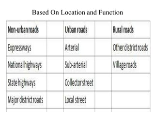
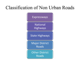
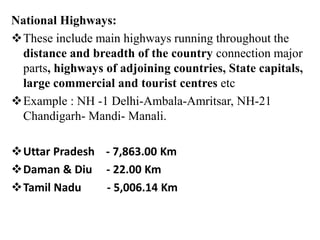
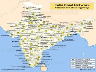
CLASSIFICATION OF
ROADWAYS
Based On Location and Function
Based on Loading
*Class 70R = Can carry 70 tonnes of Load at 30m interval.
*Class AA = Can carry 70 tonnes of Load at 90 m interval.
*Class A = Can carry extreme loads on permanent roads.
*Class B = Carries little lesser loads than Class A roads.
Based on Traffic
Traffic Density – Number of Vehicles using the road
Character of Traffic – Type of vehicle using that road
Designed Speed – Based on Speed of the vehicle.
Classification of Non Urban Roads
Expressways
National
Highways
State Highways
Major District
Roads
Other District
Roads
Indian road network of 33 lakh Km.is second largest in the
world and consists of :
Length(In Km)
• Expressways 200
• National Highways 92,851.07
• State Highways 1,31,899
• Major District Roads 4,67,763
• Rural and Other Roads 26,50,000
• Total Length 33 Lakhs Kms(Appro)
• About 65% of freight and 80% passenger traffic is carried by
the roads.
• National Highways constitute only about 1.7% of the road
network but carry about 40% of the total road traffic.
• Number of vehicles has been growing at an average pace of
10.16% per annum over the last five years.
Expressways:
The purpose of expressways would be to cater for
motility of large volumes of motor traffic at high
speeds.
They connect major areas of increasing visitor count and
they are intended to serve trips of medium and long
length in between prominent residential areas,
industrial or business concentrations and the central
business district.
 They may be divided highways with high standards of
geometrics and full or partial control of access and
provided generally with grade separation at intersections
Vehicle parking, loading and unloading of products
and passengers and pedestrian traffic are not
allowed on these kinds of highways.
The expressways are the highest class of roads in the
Indian Road Network.
These four to six lanes expressways makes faster
transport networks between many major cities and
ports of India.
The Golden Quadrilateral is a highway network in India
connecting Delhi, Mumbai, Kolkata and Chennai.
This is the largest highway project in India, initiated by
Atal Bihari Vajpayee.
One of the famous expressway in India is Mumbai-
Pune Expressway, India’s first access controlled
expressway. Two-wheeler vehicles are forbidden on the
road due to safety concerns.
There are many highway and Elevated Expressway are
under construction in major cities of India, few of them
are The Bangalore-Chennai Expressway,National
Expressway,Ganga Expressway and the longest
expressway in India, Yamuna Expressway.
The National Highway system also consists some of
the best road for driving in India.
There are several cloverleaf interchange, road bridges,
long tunnels and big flyovers are under construction on
the long Indian highways.
Mumbai-Pune Expressway:
Mumbai-Pune Expressway is India’s first six-lane
concrete, high-speed, access controlled tolled
expressway with a distance of 93 km.
This amazing highway cut down the time form Mumbai
and green city Pune to less than 2 hours at an average
speed of 80kmph.
It cleaves through the scenic Sahyadri mountain
ranges via passes and tunnels.
The longest expressway, Mumbai-Pune Expressway is
one of the best expressway in India.
It has replaced the older Mumbai-Pune an stretch of the
Mumbai-Chennai National Highway (NH 4)
National Highways:
These include main highways running throughout the
distance and breadth of the country connection major
parts, highways of adjoining countries, State capitals,
large commercial and tourist centres etc
Example : NH -1 Delhi-Ambala-Amritsar, NH-21
Chandigarh- Mandi- Manali.
Uttar Pradesh - 7,863.00 Km
Daman & Diu - 22.00 Km
Tamil Nadu - 5,006.14 Km
State Highways:
These include main arterial routes of any state connecting
district headquarters and major cities in the state and
connecting these with National Highways of the
neighboring states.
Major District Roads:
They are essential roads with a district serving parts of
production and markets, and linking these together or
while using the main highways.
Other District Roads:
They’re streets serving non-urban areas of production
and providing them with outlet to market centres,
taluka/tehsil headquarters or other main roads
6) Village Roads:
These are roads joining villages or group of villages
with each other and also to the nearest road of any
higher class
Classification of Urban Roads
Arterial Streets:
This system of streets, together with expressways
where they exist, serves as the key network for
through traffic flows.
Significant intra-urban travel, for instance, among
central downtown and outlying residential areas or
between significant suburban ‘zones develops on this
system .
These roadways may generally be spaced under 1-5
km in hugely developed central business places
and at 8 km or maybe more in sparsely developed
urban fringes.
Sub-arterial Streets:
These include functionally much like arterial streets but
with somewhat lower level of travel mobility.
Their spacing are different from about 0 – 5 km in the
central downtown to three – 5 km inside the sub-urban
fringes.
Collector Streets:
The function of collector streets should be to collect
visitors from nearby streets and feed it for the
arterial and sub-arterial streets or vice versa.
These may be located in residential neighbor hoods,
commercial areas and industrial areas Usually,
complete approach is granted on these roadways from
abutting properties
There are not car parking limitations apart from during
the peak hours
5) Local Streets:
These are intended mainly to supply use of abutting
properly and normally will not carry substantial
amounts of traffic.
 Majority of visits in urban areas originate from or
terminate on these roads.
Local streets could possibly be non commercial,
commercial or industrial, depending on the
predominant use of the nearby area.
They permit unrestricted parking and pedestrian
movements.

CLASSIFICATION OF ROADWAYS.pptx

  • 1.
  • 2.
    Based On Locationand Function
  • 3.
    Based on Loading *Class70R = Can carry 70 tonnes of Load at 30m interval. *Class AA = Can carry 70 tonnes of Load at 90 m interval. *Class A = Can carry extreme loads on permanent roads. *Class B = Carries little lesser loads than Class A roads.
  • 4.
    Based on Traffic TrafficDensity – Number of Vehicles using the road Character of Traffic – Type of vehicle using that road Designed Speed – Based on Speed of the vehicle.
  • 5.
    Classification of NonUrban Roads Expressways National Highways State Highways Major District Roads Other District Roads
  • 6.
    Indian road networkof 33 lakh Km.is second largest in the world and consists of : Length(In Km) • Expressways 200 • National Highways 92,851.07 • State Highways 1,31,899 • Major District Roads 4,67,763 • Rural and Other Roads 26,50,000 • Total Length 33 Lakhs Kms(Appro) • About 65% of freight and 80% passenger traffic is carried by the roads. • National Highways constitute only about 1.7% of the road network but carry about 40% of the total road traffic. • Number of vehicles has been growing at an average pace of 10.16% per annum over the last five years.
  • 7.
    Expressways: The purpose ofexpressways would be to cater for motility of large volumes of motor traffic at high speeds. They connect major areas of increasing visitor count and they are intended to serve trips of medium and long length in between prominent residential areas, industrial or business concentrations and the central business district.  They may be divided highways with high standards of geometrics and full or partial control of access and provided generally with grade separation at intersections Vehicle parking, loading and unloading of products and passengers and pedestrian traffic are not allowed on these kinds of highways.
  • 8.
    The expressways arethe highest class of roads in the Indian Road Network. These four to six lanes expressways makes faster transport networks between many major cities and ports of India. The Golden Quadrilateral is a highway network in India connecting Delhi, Mumbai, Kolkata and Chennai. This is the largest highway project in India, initiated by Atal Bihari Vajpayee. One of the famous expressway in India is Mumbai- Pune Expressway, India’s first access controlled expressway. Two-wheeler vehicles are forbidden on the road due to safety concerns.
  • 9.
    There are manyhighway and Elevated Expressway are under construction in major cities of India, few of them are The Bangalore-Chennai Expressway,National Expressway,Ganga Expressway and the longest expressway in India, Yamuna Expressway. The National Highway system also consists some of the best road for driving in India. There are several cloverleaf interchange, road bridges, long tunnels and big flyovers are under construction on the long Indian highways.
  • 10.
    Mumbai-Pune Expressway: Mumbai-Pune Expresswayis India’s first six-lane concrete, high-speed, access controlled tolled expressway with a distance of 93 km. This amazing highway cut down the time form Mumbai and green city Pune to less than 2 hours at an average speed of 80kmph. It cleaves through the scenic Sahyadri mountain ranges via passes and tunnels. The longest expressway, Mumbai-Pune Expressway is one of the best expressway in India. It has replaced the older Mumbai-Pune an stretch of the Mumbai-Chennai National Highway (NH 4)
  • 12.
    National Highways: These includemain highways running throughout the distance and breadth of the country connection major parts, highways of adjoining countries, State capitals, large commercial and tourist centres etc Example : NH -1 Delhi-Ambala-Amritsar, NH-21 Chandigarh- Mandi- Manali. Uttar Pradesh - 7,863.00 Km Daman & Diu - 22.00 Km Tamil Nadu - 5,006.14 Km
  • 14.
    State Highways: These includemain arterial routes of any state connecting district headquarters and major cities in the state and connecting these with National Highways of the neighboring states. Major District Roads: They are essential roads with a district serving parts of production and markets, and linking these together or while using the main highways.
  • 15.
    Other District Roads: They’restreets serving non-urban areas of production and providing them with outlet to market centres, taluka/tehsil headquarters or other main roads 6) Village Roads: These are roads joining villages or group of villages with each other and also to the nearest road of any higher class
  • 16.
    Classification of UrbanRoads Arterial Streets: This system of streets, together with expressways where they exist, serves as the key network for through traffic flows. Significant intra-urban travel, for instance, among central downtown and outlying residential areas or between significant suburban ‘zones develops on this system . These roadways may generally be spaced under 1-5 km in hugely developed central business places and at 8 km or maybe more in sparsely developed urban fringes.
  • 17.
    Sub-arterial Streets: These includefunctionally much like arterial streets but with somewhat lower level of travel mobility. Their spacing are different from about 0 – 5 km in the central downtown to three – 5 km inside the sub-urban fringes. Collector Streets: The function of collector streets should be to collect visitors from nearby streets and feed it for the arterial and sub-arterial streets or vice versa. These may be located in residential neighbor hoods, commercial areas and industrial areas Usually, complete approach is granted on these roadways from abutting properties There are not car parking limitations apart from during the peak hours
  • 18.
    5) Local Streets: Theseare intended mainly to supply use of abutting properly and normally will not carry substantial amounts of traffic.  Majority of visits in urban areas originate from or terminate on these roads. Local streets could possibly be non commercial, commercial or industrial, depending on the predominant use of the nearby area. They permit unrestricted parking and pedestrian movements.