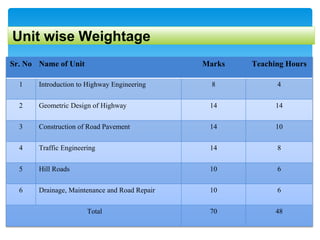
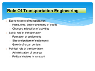
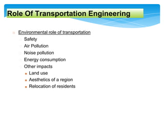
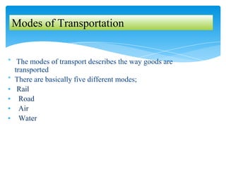
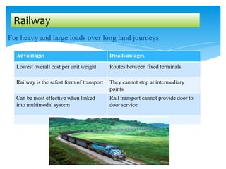
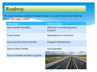
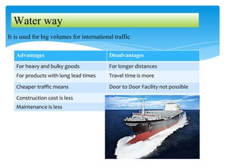
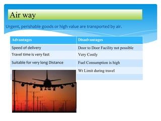
Introduction To Highway
Engineering
By
Prof. Hole G.R.
Civil Engineering Department
J.S. Polytechnic, Hadapsar,Pune
I
Unit wise Weightage
Sr. No Name of Unit Marks Teaching Hours
1 Introduction to Highway Engineering 8 4
2 Geometric Design of Highway 14 14
3 Construction of Road Pavement 14 10
4 Traffic Engineering 14 8
5 Hill Roads 10 6
6 Drainage, Maintenance and Road Repair 10 6
Total 70 48
Course Outcomes (CO’s)
SR.
No.
Course Outcomes (CO’s)
CO 1 Identify the types of road as per IRC recommendation
CO 2 Implement Geometric Design Features of different Highways
CO 3 Perform Different Test on Road Material
CO 4 Evaluate traffic flow characteristics
CO 5 Implement Hill Road construction using relevant method
CO 6 Undertake maintenance and Drainage of Road
Role Of Transportation Engineering
◻ Economic role of transportation
� Place, time, quality and utility of goods
� Changes in location of activities
◻ Social role of transportation
� Formation of settlements
� Size and pattern of settlements
� Growth of urban centers
◻ Political role of transportation
� Administration of an area
� Political choices in transport
◻ Environmental role of transportation
� Safety
� Air Pollution
� Noise pollution
� Energy consumption
� Other impacts
■ Land use
■ Aesthetics of a region
■ Relocation of residents
Role Of Transportation Engineering
Scope of Transportation Engineering
� Development,Planning & Locations
� Highway design, Geometrics & Structures
� Traffic Performance & its control
� Materials, construction & Maintenance
� Economics, Finance & Administration
* The modes of transport describes the way goods are
transported
* There are basically five different modes;
▪ Rail
▪ Road
▪ Air
▪ Water
Modes of Transportation
For heavy and large loads over long land journeys
Railway
Advantages Disadvantages
Lowest overall cost per unit weight Routes between fixed terminals
Railway is the safest form of transport They cannot stop at intermediary
points
Can be most effective when linked
into multimodal system
Rail transport cannot provide door to
door service
The most common mode of transport and it is used at least somewhere in
almost all supply chains.
Roadway
Advantages Disadvantages
Main benefit: flexibility Difficulty in monitoring exact
location
Travel speed Dependence on fuel price
Use extensive road networks Frequent Maintenance
Door to Door Facility Less Duerable
Easy to monitor location of goods
It is used for big volumes for international traffic
Water way
Advantages Disadvantages
For heavy and bulky goods For longer distances
For products with long lead times Travel time is more
Cheaper traffic means Door to Door Facility not possible
Construction cost is less
Maintenance is less
Urgent, perishable goods or high value are transported by air.
Air way
Advantages Disadvantages
Speed of delivery Door to Door Facility not possible
Travel time is very fast Very Costly
Suitable for very long Distance Fuel Consumption is high
Wt Limit during travel
History of Roads in India
◻ Ancient civilizations
■ existence of planned roads in India as old as 2500-3500 BC
◻ Mauryan period(Arthashastra written by Kautilya)
■ contained rules for regulations for traffic, depths of roads for
various purposes, and punishments for obstructing traffic
◻ Mughal period
■ Roads linked North-West and the Eastern areas through
gangetic plains
◻ British period
■ Grand-Trunk road connecting North and South
■ Neglect the road system in India
■ Military and administrative purpose only
■ Introduction of railways
■ Feeder roads to the railways
5
Cross Section Of Early Roads
Introduction to Transportation Engineering
6
Telford
Pavement
Macadam Pavement
Development of Road in India:-
1. Jayakar Committee (1927)
◻ Central government should take the proper charge from local
governments
◻ Gave more stress on long term planning programme, for a period
of 20 years (hence called twenty year plan)
◻ One of the recommendations paved the way for the
establishment of a semi-social technical body called Indian
2. Indian Road Congress (IRC) (HRB) -1934
◻ The committee suggested imposition of additional taxation on
motor transport which includes duty on motor spirit, vehicle taxation,
license fees for vehicles plying for hire, called Central road fund in
1929
3. Central Road Research Institute (CRRI)-1950
❑ dedicated research organization was constituted to carry out
4. Central Road Fund 1929
■ Extra levy (Tax) of 2.64 paisa per liter.
■ 20 % as Central reserve & 80 % is alloted for development
■ Now,revised cess is Rs.2/- per litre of petrol and
HSD (High Speed Diesel)
5. Motor Vehicle Act 1939
■ Control of drivers
■ Vehicle ownership
■ Vehicle operations on roads & traffic streams
■ Revised in 1988
6.National Highway Act 1956:
■ Declared selected highways as “National Highways
■ To enter into any land for surveys
■ To acquire land and take possession for the development
of national highways
■ Revised in 1988 and NHAI started operating on Feb 1995
Road Development in India
◻ National Highway Development Projects
◻ Pradhan Mantri Gram Sadak Yojana
◻ Road Development Plan : Vision 2021
◻ Rural Road Development Plan : Vision 2025
Modern Development in Indian Road
A. 1st 20 Year Plan (Nagpur road Plan)1943 –1963
◻ It Was first attempt to prepare a co-ordinated road
development programme in a planned manner.
◻ Roads were divided into four classes:
National highways, State highways, Major district roads, Other
district roads & Village roads
◻ Committee planned to construct 2 lakh kms of road
across the country within 20 years.
◻ Recommended the construction of star and grid pattern of
roads throughout the country.
◻ Road length should be increased so as to give a road
density of 16kms per 100 sq.km
B. 2 nd 20year Plan Bombay road congress(1961-1981)
◻ Total road length targeted to construct was about 10
lakhs.
◻ Rural roads were given specific attention by introducing
scientific method of construction
◻ Suggested that the length of the road should be
increased so as to give a road density of 32kms/100
sq.km
◻ Construction of 1600 km of expressways was also then
included in the plan.
C. Lucknow road Plan (1981 – 2001) 3rd 20 Year Plan
◻ In this plan roads are classified in to : Primary, Secondary and Tertiary System.
◻ Aimed at a road length of 12 lakh kilometres by the year 1981 resulting in
a road density of 82kms/100 sq.km
◻ All villages having population over 500 should be connected by all weather
roads
◻ 2000km Expressway have been constructed in this road plan.
Classification of Roads:
Usage during
seasons
All weather
roads
Fair
weather
roads
Type of
carriage way
Paved
roads
Un paved
roads
Type of
pavement
surfacing
Surfaced
roads
Un-surfaced
roads
Traffic
Volume
Heavy
Medium
Low
Load
Transported
/tonnage
Class I
Class II
Class III
NH : National Highway
SH : State Highway
MDR : Major District Road
ODR : Other District Road
VR : Village Road
As per Nagpur Road Plan:
▪ These are main highways running through the length and breadth of India , joining
major parts, capital of states, large industrial centers including roads required for
strategic movements are known as National Highways.
▪ The responsibility of construction and maintenance of these roads under the central
government.
▪ These are minimum 2 lane road.
▪ The minimum width of road is 7.5m.
▪ NHAI keep control on maintenance of these roads.
▪ “Golden Quadrilateral” is on of famous
scheme of NH read which connects
( DELHI-KOLKATA-CHENNAI-MUBAI)
- NH covers 2% of total road network
and it carries almost 40% traffic of country
NH : National Highway
- The highways linking up with the national highways of states, district and
important cities is called as states highway.
- Design specifications and design speed for NH and SH are same.
- The responsibility of construction and maintenance of these roads under the state
government.
- The minimum it is 2 lane road.
- The minimum width of road is 7.5m.
SH : State Highway
- The important roads within a district serving areas of production and markets and
connecting these places with each other or main highways are called as major
district road
- The responsibility of construction and maintenance of these roads under the
district authorities.
- These are minimum 2 lanes roads.
- The minimum width of road is 5m.
MDR : Major District Road
▪ The roads serving rural areas of production and providing them with outlet to
market centers, tahsil block, railway stations are known as other district roads.
▪ Lower design specification than MDR.
▪ The responsibility of construction and maintenance of these roads under the local
district authorities.
ODR : Other District Road
▪ The roads connecting villages or group of villages with each other are called as
village roads.
▪ Important for rural area development .
▪ These are single lane roads.
▪ The maintenance is under Local Panchayat.
▪ Minimum width of road is 3m.
VR : Village Road
As per Third ( Lucknow)Road Plan:
Classification of road as per Lucknow Road
Plan:
◻ Primary Road System
� Expressway – 2000 km : Based on some project formulation
� National Highways: concept of 100 km Square grids
� Total Length of Road in Country = 4.75 * (Road Density km/Km2)* Area(Km2)
� Length of the NH in country, km = Area of State(Km2)/ 50
◻ Secondary System: length of SH
� NH and SH should pass through every town and urban area: 3364 towns in the
country (Based on census data: 1981)
� By Total Area, SH , Length (km) = Area of the state/ 25 (Double of NH)
� By total number of towns: {(62.5 * no of towns in the state) – (Area of state/ 50)}
Introduction to Transportation Engineering
Length of MDR,
◻ Major District Roads
� Total length of MDR in the country = 3,00,000 km
� By Total Area, MDR , Length (km) = Area of the state/ 12.5 (Double of SH)
� By total number of towns in state : {(90*no of towns in the state)}
Introduction to Transportation Engineering
Classification of Road as per Material
1. Earthen Road
2. Water Bound Macadam (WBM) ROAD
3. Bitumen Road
4. Concrete Road
1. Earthen road:
- These are kuccha roads in which earth is the main constituent of road and probably
provided in village area.
Introduction to Transportation Engineering
Classification of Road as per Material
2. Water Bound Macadam (WBM) ROAD :-
- Consists of broken stones with size 25 mm to 75 mm are laid in three layers.
- Bottom layer is laid of bigger sized stones.
- This type of road is also provided in village area.
- Combination of bituminous and concrete roads.
Introduction to Transportation Engineering
Classification of Road as per Material
3. Bitumen Road
- Structure is flexible pavement.
- W.B.M. surface is prepared and small stones are provided; size is 16 mm to 20 mm with
bitumen and thickness is 30 mm to 40 mm.
- Bitumen act as binder.
- Life span is short and durability is less.
- Possibility of developing corrugations due to heavy traffic.
- Repair easy but maintenance cost is more.
Introduction to Transportation Engineering
Classification of Road as per Material
4. Concrete Road
- Structure of rigid pavement.
- Life span is long and durability is more.
- No possibility of developing corrugations due to rigid pavement.
- Repair work is difficult and maintenance cost is quite low.
Introduction to Transportation Engineering
Classification of Road as per Traffic Volume
• According to IRC the roads are classified depending upon Traffic volume are as fallows:
Introduction to Transportation Engineering
Sr. No. Types of Road Vehicles per day
1 Very heavy traffic roads Above 600
2 Heavy traffic roads 251 to 600
3 Medium traffic roads 70 to 250
4 Light traffic roads Below 70
Classification of Road as per Load Capacity
• According to IRC the roads are classified depending upon Load carrying Capacity are as
fallows:
Introduction to Transportation Engineering
Sr. No. Types of Road Tonnage /Day
1 Very heavy traffic roads Above 1524
2 Heavy traffic roads 1017 to 1524
3 Medium traffic roads 508 to 1017
4 Light traffic roads Below 508
Classification of Urban Road:
▪ Expressways
▪ Arterial Streets
▪ Sub-Arterial Streets
▪ Collector’s Streets
▪ Local Streets
Introduction to Transportation Engineering
Classification of Urban Road:
Introduction to Transportation Engineering
Classification of Urban Road:
1. Expressway:-
• For speedy and heavy traffic
• Pedestrians are not allowed.
• Complete separation of opposite
moving vehicles.
• Crossing and Sharp Curves Strictly
Avoided
• Design Speed = 100kmph.
2. Arterial Streets:-
▪ For the heavy/important traffic inside
the city
▪ Pedestrians are allowed to cross only at
intersections.
▪ Parking, loading, unloading prohibited.
▪ Connect city traffic to Expressway.
▪ Makes connectivity between central
city and outside industry.
▪ Design Speed = 80kmph
Introduction to Transportation Engineering
Classification of Urban Road:
3. Sub-Arterial Streets:-
• Less traffic as compared to arterial
roads.
• Pedestrians are allowed to cross road
only at intersections.
• Loading and Parking are not
allowed.
• They connects important town
centers.
• Intersections are provided with
signals.
4. Collector Streets:-
▪ It serves the traffic from local street to
sub-arterial street.
▪ Full access are allowed along side of
road.
▪ Situated in commercial ,residential,
industrial area.
▪ Few parking restriction during peak hr.
Introduction to Transportation Engineering
5. Local Street:-
▪ It provide open access to properties
along sides of road.
▪ Not carry heavy traffic.
▪ Slow moving traffic.
▪ Parking and loading unloading
are allowed.
▪ Pedestrians are allowed to move.
Classification of Urban Road:
�Rectangular or Block Pattern
�Hexagonal Pattern
�Radial Pattern.
1. Star and Block Pattern
2. Star and Circular Pattern
3. Star And Grid Patterns
Urban Road Patterns
▪ The whole area is divided into rectangular blocks of plots, with
streets intersecting at right angles.
▪ The main road which passes through the center of the area should
be sufficiently wide and other branch roads may be comparatively
narrow.
Advantages:-
▪ Rectangular block can be further divided in to small blocks for
future development.
▪ Construction and Maintenance Easier.
Disadvantages:-
▪ As there is more no of intersections at right angle so chances of
accident more.
1.Rectangular or Block Pattern
Hexagonal Pattern
Hexagonal Pattern.
• In this pattern, the entire area is provided with a network of roads
formatting hexagonal figures.
• At each corner of the hexagon, three roads meet the built-up area
boundary by the sides of the hexagons is further divided in
suitable sizes.
Advantages:
• Three roads meet the built-up area boundary by the sides of the
hexagons.
Limitations:
• Traffic signs, pavement markings, and lighting should be adequate
so that drivers are aware that they should reduce their travel speed.
Radial Pattern.
1. Star and Block Pattern:-
▪ In this pattern, the entire area is divided into a network of roads radiating from
the business outwardly.
▪ In between radiating main roads, the built-up area may be planned with
rectangular block.
▪ Reduces level of congestion at the primary bottleneck location.
▪ Vehicles face each other less than block pattern.
Radial Pattern.
2. Star and Circular Pattern:-
▪ In this system, the main radial roads and central business area are connected
together with concentric roads.
▪ In these areas, boundary by adjacent radial roads and corresponding circular
roads, the built-up area is planned with a curved block system.
Radial Pattern.
3. Star and Grid Pattern:-
▪ It is a combination of radial and grid pattern.
▪ A radial network of roads radiate from the center outwardly.
▪ Radial streets are interconnected by providing grid pattern in between the main
streets.
▪ Improve land use efficiency and unit density.
▪ The Nagpur road plan formulae were prepared on the assumption of Grid
pattern.
Road Alignment
The position or layout of the centre line of the highway
on the ground is called the alignment.
Requirment of Good Alignment
 Short:-
The alignment of road road connecting two stations must
be short.
 Easy:
The alignment must be easy to construct and maintain and
also it should be easy for vehicle operation.
 Safe:
It should be safe in case of designing the horizontal and
vertical curves.
 Economical:
The alignment should be selected in such a way that it is
economical during construction.
Factors Controlling Alignment
Following are the factors which affect the alignment of
road.
1) Obligatory Points:
• These are the points through which alignment is passing.
• The Alignment of should crosses minimum Obligatory Points.
• Following are the Obligatory Points:
- Hills
- Rivers
- City/ Village
- Historical Monuments
- Temples/ Church
- School and Hospitals
Factors Controlling Alignment
2) Geometric design features :
• To Facilitate easy grade and curvature
• To Avoid sudden changes in sight distance, especially near
crossings.
• To Avoid sharp horizontal curves.
• To Avoid road intersections near bend or at the top or bottom of a
hill.
3) Traffic:
• The traffic trend or direction is
affect the alignment of road.
• So that traffic survey should be
carried out.
• Alignment should be laid such that maximum traffic is to be
covered.
Factors Controlling Alignment
4) Topographical control points:
• The alignment, where possible should avoid passing through
1. Marshy and low lying land with poor drainage
2. Unstable hilly features
3. Flood prone areas
4. Avalanche prone areas
5) Materials and constructional features:
• Deep cutting should be avoided
• Earth work is to be balanced; quantities for filling and excavation
• Alignment should preferably be through better soil area to
minimize pavement thickness
• Location may be near sources of embankment and pavement
materials
Factors Controlling Alignment
6) Economic Factors:
• Capital cost
• Maintenance Cost
• Operational cost
• Road User Cost
• Embankment and deep cuttings cost
7) Other Considerations:
• Engineering feasibility
• Environmental consideration
• Social consideration
• Political Acceptability
• Monotony.
Procedure of Fixing Alignment of Road
1. Transferring centerline from map to ground:-
• In this centerline marked in plan is transferred on ground using transit
theodolite.
2. Fixing reference points –
• The reference points on both side of alignment are marked permanently on ground,
which helps during construction.
3.Plotting curves in alignment –
• The circular or transition curve are plotted using long chord or deflection angle method
very accurately The start and end points are also marked with references.
4. Measuring the length of alignment –
• The total length of alignment as per design is finally checked either by using tape or
transit theodolite.
Survey or Data collection for Highway
Project
1. Natural and man made features.
2. Proposed Geometric Design elements.
3. Number of cross drainage structures.
4. Soil characteristics
5. Source of construction materials.
6. Geological formation, type of rocks.
7. Drainage
Drawing and Report Required in Highway
Project
1. Key map
2. Index map
3. Preliminary survey plans
4. Detailed plan and longitudinal section
5. Detailed cross section
6. Land acquisition plans
7. Drawings of cross drainage and other retaining structures
8. Drawings of road intersections.
Engineering Surveys for Highway locations
 Provisional alignment Identification
(Map study)
 Reconnaissance survey
 Preliminary survey
 Final location to determine center line and
detailed survey
Engineering Surveys for Highway locations
1. Provisional alignment Identification ( Map study)
• Base Map preparation
Topographical map (SoI)
Scale -1: 2,50,000
1: 50,000
1: 25,000
• Shows man made and natural features and contour lines at 15 or 30m interval.
• Shows possible alignments with obligatory points and minimum number of
cross drainage structures.
Engineering Surveys for Highway locations
2. Reconnaissance survey
• Map updating – to confirm features indicated on map.
• Checking for:
1. Number of cross drainage structures.
2. High Flood Level (HFL)
3. Confirming Length and value of gradient to IRC standards.
4. Soil Characteristics.
5. Geological features.
6. Proximity to source of construction materials- quarries, water sources.
• Prepare a report on merits and demerits and profile map of scale 1:50,000.
Engineering Surveys for Highway locations
 Purposes of reconnaissance survey.
a) To collect the details of obstruction along the route which are not
available in the map.
b) To collect geological features of field.
c) To collect information regarding the availability of local
construction material, water and labor.
d) To determine the approximate values of gradient, length of
gradients and radius of curves of alternate alignments.
e) To locate the obligatory points along the alternative routes.
f) To determine approximate estimate of the total cost of
construction of the road along each route.
g) To determine two or three best possible routes.
Engineering Surveys for Highway locations
3. Preliminary survey
• Base Plan:
Hz Vr
Built up area/hilly terrain 1:1000 1:100
Plain and rolling terrain 1:2500 1:250
• Establish center line
• Incorporation of natural and man made features
• Longitudinal and cross sectional profile (Leveling).
• Other studies:
Drainage, Hydrological, soil, Traffic and Materials.
• Finalization of the best alignment
Comparative analysis.
Choose best alignment among alternatives.
Design geometric elements.
Engineering Surveys for Highway locations
 Objects of preliminary survey.
The preliminary survey for any road construction project is done for following
objectives
1. To survey various alternative alignments proposed after the reconnaissance and
to collect all the necessary physical information and details of topography,
drainage and soil.
2. To estimate the quantity of earthwork materials and other construction aspects
and to work out cost of alternate proposal.
3. To compare the different proposals in view of the requirement of good
alignment..
4. To finalize the best alignment from all consideration.
5 To know number of cross-drainage works and other obligatory points.
Engineering Surveys for Highway locations
4. Detailed Survey For Final Location:
 Transferring the alignment on to ground.
 Detail Survey – leveling work for longitudinal and transverse direction.
 Intervals for cross sectional leveling
Plain 50 – 100m
Rolling 50 – 75m
Built up 50m
Hilly 20m
• Soil Profile
Important Question Bank
Sr. No Question Marks
1 State four characteristics of Road transport 4
2 Discuss importance of a good network of roads in India 4
3 Classify the roads according to Nagpur Road Plan 4
4 Give classification of urban roads. 4
5 Explain Modes of transportation in Details 4
6 Define road alignment. Write four factor affecting it 4
7 State any four factors affecting alignment of road. State four
requirements of an ideal alignment
4
8 List out the various drawings prepared for a highway project and explain
the importance of any one drawing in brief
4
9 What is the use of various drawings prepared for a highway project 4

1.introduction to highway engineering

  • 1.
    Introduction To Highway Engineering By Prof.Hole G.R. Civil Engineering Department J.S. Polytechnic, Hadapsar,Pune I
  • 2.
    Unit wise Weightage Sr.No Name of Unit Marks Teaching Hours 1 Introduction to Highway Engineering 8 4 2 Geometric Design of Highway 14 14 3 Construction of Road Pavement 14 10 4 Traffic Engineering 14 8 5 Hill Roads 10 6 6 Drainage, Maintenance and Road Repair 10 6 Total 70 48
  • 3.
    Course Outcomes (CO’s) SR. No. CourseOutcomes (CO’s) CO 1 Identify the types of road as per IRC recommendation CO 2 Implement Geometric Design Features of different Highways CO 3 Perform Different Test on Road Material CO 4 Evaluate traffic flow characteristics CO 5 Implement Hill Road construction using relevant method CO 6 Undertake maintenance and Drainage of Road
  • 4.
    Role Of TransportationEngineering ◻ Economic role of transportation � Place, time, quality and utility of goods � Changes in location of activities ◻ Social role of transportation � Formation of settlements � Size and pattern of settlements � Growth of urban centers ◻ Political role of transportation � Administration of an area � Political choices in transport
  • 5.
    ◻ Environmental roleof transportation � Safety � Air Pollution � Noise pollution � Energy consumption � Other impacts ■ Land use ■ Aesthetics of a region ■ Relocation of residents Role Of Transportation Engineering
  • 6.
    Scope of TransportationEngineering � Development,Planning & Locations � Highway design, Geometrics & Structures � Traffic Performance & its control � Materials, construction & Maintenance � Economics, Finance & Administration
  • 7.
    * The modesof transport describes the way goods are transported * There are basically five different modes; ▪ Rail ▪ Road ▪ Air ▪ Water Modes of Transportation
  • 8.
    For heavy andlarge loads over long land journeys Railway Advantages Disadvantages Lowest overall cost per unit weight Routes between fixed terminals Railway is the safest form of transport They cannot stop at intermediary points Can be most effective when linked into multimodal system Rail transport cannot provide door to door service
  • 9.
    The most commonmode of transport and it is used at least somewhere in almost all supply chains. Roadway Advantages Disadvantages Main benefit: flexibility Difficulty in monitoring exact location Travel speed Dependence on fuel price Use extensive road networks Frequent Maintenance Door to Door Facility Less Duerable Easy to monitor location of goods
  • 10.
    It is usedfor big volumes for international traffic Water way Advantages Disadvantages For heavy and bulky goods For longer distances For products with long lead times Travel time is more Cheaper traffic means Door to Door Facility not possible Construction cost is less Maintenance is less
  • 11.
    Urgent, perishable goodsor high value are transported by air. Air way Advantages Disadvantages Speed of delivery Door to Door Facility not possible Travel time is very fast Very Costly Suitable for very long Distance Fuel Consumption is high Wt Limit during travel
  • 12.
    History of Roadsin India ◻ Ancient civilizations ■ existence of planned roads in India as old as 2500-3500 BC ◻ Mauryan period(Arthashastra written by Kautilya) ■ contained rules for regulations for traffic, depths of roads for various purposes, and punishments for obstructing traffic ◻ Mughal period ■ Roads linked North-West and the Eastern areas through gangetic plains ◻ British period ■ Grand-Trunk road connecting North and South ■ Neglect the road system in India ■ Military and administrative purpose only ■ Introduction of railways ■ Feeder roads to the railways 5
  • 13.
    Cross Section OfEarly Roads Introduction to Transportation Engineering 6 Telford Pavement Macadam Pavement
  • 14.
    Development of Roadin India:- 1. Jayakar Committee (1927) ◻ Central government should take the proper charge from local governments ◻ Gave more stress on long term planning programme, for a period of 20 years (hence called twenty year plan) ◻ One of the recommendations paved the way for the establishment of a semi-social technical body called Indian 2. Indian Road Congress (IRC) (HRB) -1934 ◻ The committee suggested imposition of additional taxation on motor transport which includes duty on motor spirit, vehicle taxation, license fees for vehicles plying for hire, called Central road fund in 1929 3. Central Road Research Institute (CRRI)-1950 ❑ dedicated research organization was constituted to carry out
  • 15.
    4. Central RoadFund 1929 ■ Extra levy (Tax) of 2.64 paisa per liter. ■ 20 % as Central reserve & 80 % is alloted for development ■ Now,revised cess is Rs.2/- per litre of petrol and HSD (High Speed Diesel) 5. Motor Vehicle Act 1939 ■ Control of drivers ■ Vehicle ownership ■ Vehicle operations on roads & traffic streams ■ Revised in 1988 6.National Highway Act 1956: ■ Declared selected highways as “National Highways ■ To enter into any land for surveys ■ To acquire land and take possession for the development of national highways ■ Revised in 1988 and NHAI started operating on Feb 1995
  • 16.
    Road Development inIndia ◻ National Highway Development Projects ◻ Pradhan Mantri Gram Sadak Yojana ◻ Road Development Plan : Vision 2021 ◻ Rural Road Development Plan : Vision 2025
  • 17.
    Modern Development inIndian Road A. 1st 20 Year Plan (Nagpur road Plan)1943 –1963 ◻ It Was first attempt to prepare a co-ordinated road development programme in a planned manner. ◻ Roads were divided into four classes: National highways, State highways, Major district roads, Other district roads & Village roads ◻ Committee planned to construct 2 lakh kms of road across the country within 20 years. ◻ Recommended the construction of star and grid pattern of roads throughout the country. ◻ Road length should be increased so as to give a road density of 16kms per 100 sq.km
  • 18.
    B. 2 nd20year Plan Bombay road congress(1961-1981) ◻ Total road length targeted to construct was about 10 lakhs. ◻ Rural roads were given specific attention by introducing scientific method of construction ◻ Suggested that the length of the road should be increased so as to give a road density of 32kms/100 sq.km ◻ Construction of 1600 km of expressways was also then included in the plan.
  • 19.
    C. Lucknow roadPlan (1981 – 2001) 3rd 20 Year Plan ◻ In this plan roads are classified in to : Primary, Secondary and Tertiary System. ◻ Aimed at a road length of 12 lakh kilometres by the year 1981 resulting in a road density of 82kms/100 sq.km ◻ All villages having population over 500 should be connected by all weather roads ◻ 2000km Expressway have been constructed in this road plan.
  • 20.
    Classification of Roads: Usageduring seasons All weather roads Fair weather roads Type of carriage way Paved roads Un paved roads Type of pavement surfacing Surfaced roads Un-surfaced roads Traffic Volume Heavy Medium Low Load Transported /tonnage Class I Class II Class III
  • 21.
    NH : NationalHighway SH : State Highway MDR : Major District Road ODR : Other District Road VR : Village Road As per Nagpur Road Plan:
  • 22.
    ▪ These aremain highways running through the length and breadth of India , joining major parts, capital of states, large industrial centers including roads required for strategic movements are known as National Highways. ▪ The responsibility of construction and maintenance of these roads under the central government. ▪ These are minimum 2 lane road. ▪ The minimum width of road is 7.5m. ▪ NHAI keep control on maintenance of these roads. ▪ “Golden Quadrilateral” is on of famous scheme of NH read which connects ( DELHI-KOLKATA-CHENNAI-MUBAI) - NH covers 2% of total road network and it carries almost 40% traffic of country NH : National Highway
  • 23.
    - The highwayslinking up with the national highways of states, district and important cities is called as states highway. - Design specifications and design speed for NH and SH are same. - The responsibility of construction and maintenance of these roads under the state government. - The minimum it is 2 lane road. - The minimum width of road is 7.5m. SH : State Highway
  • 24.
    - The importantroads within a district serving areas of production and markets and connecting these places with each other or main highways are called as major district road - The responsibility of construction and maintenance of these roads under the district authorities. - These are minimum 2 lanes roads. - The minimum width of road is 5m. MDR : Major District Road
  • 25.
    ▪ The roadsserving rural areas of production and providing them with outlet to market centers, tahsil block, railway stations are known as other district roads. ▪ Lower design specification than MDR. ▪ The responsibility of construction and maintenance of these roads under the local district authorities. ODR : Other District Road
  • 26.
    ▪ The roadsconnecting villages or group of villages with each other are called as village roads. ▪ Important for rural area development . ▪ These are single lane roads. ▪ The maintenance is under Local Panchayat. ▪ Minimum width of road is 3m. VR : Village Road
  • 27.
    As per Third( Lucknow)Road Plan:
  • 28.
    Classification of roadas per Lucknow Road Plan: ◻ Primary Road System � Expressway – 2000 km : Based on some project formulation � National Highways: concept of 100 km Square grids � Total Length of Road in Country = 4.75 * (Road Density km/Km2)* Area(Km2) � Length of the NH in country, km = Area of State(Km2)/ 50 ◻ Secondary System: length of SH � NH and SH should pass through every town and urban area: 3364 towns in the country (Based on census data: 1981) � By Total Area, SH , Length (km) = Area of the state/ 25 (Double of NH) � By total number of towns: {(62.5 * no of towns in the state) – (Area of state/ 50)} Introduction to Transportation Engineering
  • 29.
    Length of MDR, ◻Major District Roads � Total length of MDR in the country = 3,00,000 km � By Total Area, MDR , Length (km) = Area of the state/ 12.5 (Double of SH) � By total number of towns in state : {(90*no of towns in the state)} Introduction to Transportation Engineering
  • 30.
    Classification of Roadas per Material 1. Earthen Road 2. Water Bound Macadam (WBM) ROAD 3. Bitumen Road 4. Concrete Road 1. Earthen road: - These are kuccha roads in which earth is the main constituent of road and probably provided in village area. Introduction to Transportation Engineering
  • 31.
    Classification of Roadas per Material 2. Water Bound Macadam (WBM) ROAD :- - Consists of broken stones with size 25 mm to 75 mm are laid in three layers. - Bottom layer is laid of bigger sized stones. - This type of road is also provided in village area. - Combination of bituminous and concrete roads. Introduction to Transportation Engineering
  • 32.
    Classification of Roadas per Material 3. Bitumen Road - Structure is flexible pavement. - W.B.M. surface is prepared and small stones are provided; size is 16 mm to 20 mm with bitumen and thickness is 30 mm to 40 mm. - Bitumen act as binder. - Life span is short and durability is less. - Possibility of developing corrugations due to heavy traffic. - Repair easy but maintenance cost is more. Introduction to Transportation Engineering
  • 33.
    Classification of Roadas per Material 4. Concrete Road - Structure of rigid pavement. - Life span is long and durability is more. - No possibility of developing corrugations due to rigid pavement. - Repair work is difficult and maintenance cost is quite low. Introduction to Transportation Engineering
  • 34.
    Classification of Roadas per Traffic Volume • According to IRC the roads are classified depending upon Traffic volume are as fallows: Introduction to Transportation Engineering Sr. No. Types of Road Vehicles per day 1 Very heavy traffic roads Above 600 2 Heavy traffic roads 251 to 600 3 Medium traffic roads 70 to 250 4 Light traffic roads Below 70
  • 35.
    Classification of Roadas per Load Capacity • According to IRC the roads are classified depending upon Load carrying Capacity are as fallows: Introduction to Transportation Engineering Sr. No. Types of Road Tonnage /Day 1 Very heavy traffic roads Above 1524 2 Heavy traffic roads 1017 to 1524 3 Medium traffic roads 508 to 1017 4 Light traffic roads Below 508
  • 36.
    Classification of UrbanRoad: ▪ Expressways ▪ Arterial Streets ▪ Sub-Arterial Streets ▪ Collector’s Streets ▪ Local Streets Introduction to Transportation Engineering
  • 37.
    Classification of UrbanRoad: Introduction to Transportation Engineering
  • 38.
    Classification of UrbanRoad: 1. Expressway:- • For speedy and heavy traffic • Pedestrians are not allowed. • Complete separation of opposite moving vehicles. • Crossing and Sharp Curves Strictly Avoided • Design Speed = 100kmph. 2. Arterial Streets:- ▪ For the heavy/important traffic inside the city ▪ Pedestrians are allowed to cross only at intersections. ▪ Parking, loading, unloading prohibited. ▪ Connect city traffic to Expressway. ▪ Makes connectivity between central city and outside industry. ▪ Design Speed = 80kmph Introduction to Transportation Engineering
  • 39.
    Classification of UrbanRoad: 3. Sub-Arterial Streets:- • Less traffic as compared to arterial roads. • Pedestrians are allowed to cross road only at intersections. • Loading and Parking are not allowed. • They connects important town centers. • Intersections are provided with signals. 4. Collector Streets:- ▪ It serves the traffic from local street to sub-arterial street. ▪ Full access are allowed along side of road. ▪ Situated in commercial ,residential, industrial area. ▪ Few parking restriction during peak hr. Introduction to Transportation Engineering
  • 40.
    5. Local Street:- ▪It provide open access to properties along sides of road. ▪ Not carry heavy traffic. ▪ Slow moving traffic. ▪ Parking and loading unloading are allowed. ▪ Pedestrians are allowed to move. Classification of Urban Road:
  • 41.
    �Rectangular or BlockPattern �Hexagonal Pattern �Radial Pattern. 1. Star and Block Pattern 2. Star and Circular Pattern 3. Star And Grid Patterns Urban Road Patterns
  • 42.
    ▪ The wholearea is divided into rectangular blocks of plots, with streets intersecting at right angles. ▪ The main road which passes through the center of the area should be sufficiently wide and other branch roads may be comparatively narrow. Advantages:- ▪ Rectangular block can be further divided in to small blocks for future development. ▪ Construction and Maintenance Easier. Disadvantages:- ▪ As there is more no of intersections at right angle so chances of accident more. 1.Rectangular or Block Pattern
  • 43.
  • 44.
  • 45.
    Hexagonal Pattern. • Inthis pattern, the entire area is provided with a network of roads formatting hexagonal figures. • At each corner of the hexagon, three roads meet the built-up area boundary by the sides of the hexagons is further divided in suitable sizes. Advantages: • Three roads meet the built-up area boundary by the sides of the hexagons. Limitations: • Traffic signs, pavement markings, and lighting should be adequate so that drivers are aware that they should reduce their travel speed.
  • 46.
    Radial Pattern. 1. Starand Block Pattern:- ▪ In this pattern, the entire area is divided into a network of roads radiating from the business outwardly. ▪ In between radiating main roads, the built-up area may be planned with rectangular block. ▪ Reduces level of congestion at the primary bottleneck location. ▪ Vehicles face each other less than block pattern.
  • 47.
    Radial Pattern. 2. Starand Circular Pattern:- ▪ In this system, the main radial roads and central business area are connected together with concentric roads. ▪ In these areas, boundary by adjacent radial roads and corresponding circular roads, the built-up area is planned with a curved block system.
  • 48.
    Radial Pattern. 3. Starand Grid Pattern:- ▪ It is a combination of radial and grid pattern. ▪ A radial network of roads radiate from the center outwardly. ▪ Radial streets are interconnected by providing grid pattern in between the main streets. ▪ Improve land use efficiency and unit density. ▪ The Nagpur road plan formulae were prepared on the assumption of Grid pattern.
  • 49.
    Road Alignment The positionor layout of the centre line of the highway on the ground is called the alignment.
  • 50.
    Requirment of GoodAlignment  Short:- The alignment of road road connecting two stations must be short.  Easy: The alignment must be easy to construct and maintain and also it should be easy for vehicle operation.  Safe: It should be safe in case of designing the horizontal and vertical curves.  Economical: The alignment should be selected in such a way that it is economical during construction.
  • 51.
    Factors Controlling Alignment Followingare the factors which affect the alignment of road. 1) Obligatory Points: • These are the points through which alignment is passing. • The Alignment of should crosses minimum Obligatory Points. • Following are the Obligatory Points: - Hills - Rivers - City/ Village - Historical Monuments - Temples/ Church - School and Hospitals
  • 52.
    Factors Controlling Alignment 2)Geometric design features : • To Facilitate easy grade and curvature • To Avoid sudden changes in sight distance, especially near crossings. • To Avoid sharp horizontal curves. • To Avoid road intersections near bend or at the top or bottom of a hill. 3) Traffic: • The traffic trend or direction is affect the alignment of road. • So that traffic survey should be carried out. • Alignment should be laid such that maximum traffic is to be covered.
  • 53.
    Factors Controlling Alignment 4)Topographical control points: • The alignment, where possible should avoid passing through 1. Marshy and low lying land with poor drainage 2. Unstable hilly features 3. Flood prone areas 4. Avalanche prone areas 5) Materials and constructional features: • Deep cutting should be avoided • Earth work is to be balanced; quantities for filling and excavation • Alignment should preferably be through better soil area to minimize pavement thickness • Location may be near sources of embankment and pavement materials
  • 54.
    Factors Controlling Alignment 6)Economic Factors: • Capital cost • Maintenance Cost • Operational cost • Road User Cost • Embankment and deep cuttings cost 7) Other Considerations: • Engineering feasibility • Environmental consideration • Social consideration • Political Acceptability • Monotony.
  • 55.
    Procedure of FixingAlignment of Road 1. Transferring centerline from map to ground:- • In this centerline marked in plan is transferred on ground using transit theodolite. 2. Fixing reference points – • The reference points on both side of alignment are marked permanently on ground, which helps during construction. 3.Plotting curves in alignment – • The circular or transition curve are plotted using long chord or deflection angle method very accurately The start and end points are also marked with references. 4. Measuring the length of alignment – • The total length of alignment as per design is finally checked either by using tape or transit theodolite.
  • 56.
    Survey or Datacollection for Highway Project 1. Natural and man made features. 2. Proposed Geometric Design elements. 3. Number of cross drainage structures. 4. Soil characteristics 5. Source of construction materials. 6. Geological formation, type of rocks. 7. Drainage
  • 57.
    Drawing and ReportRequired in Highway Project 1. Key map 2. Index map 3. Preliminary survey plans 4. Detailed plan and longitudinal section 5. Detailed cross section 6. Land acquisition plans 7. Drawings of cross drainage and other retaining structures 8. Drawings of road intersections.
  • 58.
    Engineering Surveys forHighway locations  Provisional alignment Identification (Map study)  Reconnaissance survey  Preliminary survey  Final location to determine center line and detailed survey
  • 59.
    Engineering Surveys forHighway locations 1. Provisional alignment Identification ( Map study) • Base Map preparation Topographical map (SoI) Scale -1: 2,50,000 1: 50,000 1: 25,000 • Shows man made and natural features and contour lines at 15 or 30m interval. • Shows possible alignments with obligatory points and minimum number of cross drainage structures.
  • 60.
    Engineering Surveys forHighway locations 2. Reconnaissance survey • Map updating – to confirm features indicated on map. • Checking for: 1. Number of cross drainage structures. 2. High Flood Level (HFL) 3. Confirming Length and value of gradient to IRC standards. 4. Soil Characteristics. 5. Geological features. 6. Proximity to source of construction materials- quarries, water sources. • Prepare a report on merits and demerits and profile map of scale 1:50,000.
  • 61.
    Engineering Surveys forHighway locations  Purposes of reconnaissance survey. a) To collect the details of obstruction along the route which are not available in the map. b) To collect geological features of field. c) To collect information regarding the availability of local construction material, water and labor. d) To determine the approximate values of gradient, length of gradients and radius of curves of alternate alignments. e) To locate the obligatory points along the alternative routes. f) To determine approximate estimate of the total cost of construction of the road along each route. g) To determine two or three best possible routes.
  • 62.
    Engineering Surveys forHighway locations 3. Preliminary survey • Base Plan: Hz Vr Built up area/hilly terrain 1:1000 1:100 Plain and rolling terrain 1:2500 1:250 • Establish center line • Incorporation of natural and man made features • Longitudinal and cross sectional profile (Leveling). • Other studies: Drainage, Hydrological, soil, Traffic and Materials. • Finalization of the best alignment Comparative analysis. Choose best alignment among alternatives. Design geometric elements.
  • 63.
    Engineering Surveys forHighway locations  Objects of preliminary survey. The preliminary survey for any road construction project is done for following objectives 1. To survey various alternative alignments proposed after the reconnaissance and to collect all the necessary physical information and details of topography, drainage and soil. 2. To estimate the quantity of earthwork materials and other construction aspects and to work out cost of alternate proposal. 3. To compare the different proposals in view of the requirement of good alignment.. 4. To finalize the best alignment from all consideration. 5 To know number of cross-drainage works and other obligatory points.
  • 64.
    Engineering Surveys forHighway locations 4. Detailed Survey For Final Location:  Transferring the alignment on to ground.  Detail Survey – leveling work for longitudinal and transverse direction.  Intervals for cross sectional leveling Plain 50 – 100m Rolling 50 – 75m Built up 50m Hilly 20m • Soil Profile
  • 65.
    Important Question Bank Sr.No Question Marks 1 State four characteristics of Road transport 4 2 Discuss importance of a good network of roads in India 4 3 Classify the roads according to Nagpur Road Plan 4 4 Give classification of urban roads. 4 5 Explain Modes of transportation in Details 4 6 Define road alignment. Write four factor affecting it 4 7 State any four factors affecting alignment of road. State four requirements of an ideal alignment 4 8 List out the various drawings prepared for a highway project and explain the importance of any one drawing in brief 4 9 What is the use of various drawings prepared for a highway project 4