SlideShare a Scribd company logo
Yoichi Kayama
CKANへの
空間情報機能拡張
実装の試み
Self introduction
 OSGeo.JP Board member
 OSGeo.org Charter member
 A member of GIS Association of Japan
(Also a member of FOSS4G SIG)
 A Coordinator of QGIS Japanese translation
team
 GIS Programer and Researcher
at Aeroasahi Crporation
Twitter ID @pokopen
 A member of Association for Promotion of
Infrastructure Geospatial Information Distribution
2013 G8 has announced
the Open Data Charter
Governments of many
countries began
to publish data on the Internet in
response to this charter
https://data.gov.uk/
https://www.data.gov/
The government of Japan also began
to make the data public site
But
Functions, such as to preview the
spatial data in the map in these the
Japanese government of the site was
not implemented
The Japanese government is
promoting a project to utilization of
digital spatial information in parallel
with the open data
http://www.cas.go.jp/jp/seisaku/sokuitiri/yosan/h26_gsuishin.pdf
Spatial information related project budget of the Japanese government (2013-2020)
An overview of the plan of the government
related to the spatial information
Launch an organization to operate it by creating a foundation
system of spatial information
Construction of Disaster Prevention System
Improve the use of IT in agriculture, forestry and
fisheries
Activate the local activities
To expand the project that uses spatial information technology
abroad
I described in this presentation about the
marked project in the following red rectangle
Launch an organization to operate it by creating a foundation
system of spatial information
Construction of Disaster Prevention System
Improve the use of IT in agriculture, forestry and
fisheries
Activate the local activities
To expand the project that uses spatial information technology
abroad
2014-2015 Ministry of Internal
Affairs and Communications has
developed a system named G space
platform
2014-2015 Ministry of Internal
Affairs and Communications has
developed a system named G space
platform
These groups gave
the system development
work
I did the work of creating
mechanisms to use the spatial
information in a combination of
open source software in this team
These groups gave
the system development
work
This year
Ministry of Land, Infrastructure and
Transport is preparing for the
operation of this system
This year
Ministry of Land, Infrastructure and
Transport is preparing for the
operation of this system
AIGID
(Assosiation for Promotion of
Infrastructure Geospatial
Information Distribution)
will make the operation of the system
I am also a member of the AIGID.
I work for publishing this system in
AIGID current.
AIGID
(Assosiation for Promotion of
Infrastructure Geospatial
Information Distribution)
will make the operation of the system
・会員情報管理
・営業活動
・登録依頼
法人
user
公共
団体
G空間プラットフォーム
結果表示
検索
・キーワード検索
・カテゴリ検索
・空間範囲検索
道路・建物情報
ボーリング情報
気象・防災情報
ダウンロード
公共施設情報
メタデータ
テーブル
JMP2.0
OGC関連
オープンデータ
関連共通
実データとの
連携Key
実データ
File Server
・メタ情報表示
・地図描画
WebGISエンジン
・実データ
・ダウンロード
・ユーザ登録
・ユーザ情報変更
・パスワード変更
ユーザ登録・
情報変更
実データ
登録
提供者
・プロジェクトシステムを想定
・各種履歴管理
・メタデータ(半)自動生成
・ライセンス確認
事務局
登録情報
直接データを登録も可
航空写真
・データ登録
・ライセンス決
定
・データ修正
・データ削除
PostgreSQL / PostGIS
zip,PDF,XML,etc.
一般
ユーザ
検索・発見機能
ポイント
ポリゴン
ポリライン
・画像情報
閲覧機能
(加工・解析機能)
データ入手機能
利用者管理機
能
ユーザデータ
テーブル
User Table
メタ情報
登録
メタデータ
実データ
登録機能
外部連携
システム
登録支援機能
実データ
メタデータ
データ
提供
Geocoding
クローリング
連携
連携
・登録状況
・進捗管理
・フォーマット変換
・データ加工・登録
Database
防災情報
ハザードマップ
実データメタデータ
API取得
変換・編集機能
Metadata
Table
実データ
+
メタ情報
結果
(メタ情報)
・ユーザ登録
・ユーザ情報変更
・パスワード変更
保有者登録機
能
・データ評価
・SNS投稿
情報評価機能評価・コメン
ト
一部の動的
データ
道路・公共交通
情報
プローブ情報
人の移動情報
・ストリーミングサーバ
・DBサーバによる管理
・一部データの可視化
動的データの変換
・登録機能
管理
登録データ
チェック
Harvesting
カタログサービス(CKAN)&CMS Drupal)
System configuration
CKAN
Solr
Drupal
PostgreSQL
PostGIS
GeoServer
GDAL/OGR
Apache
Leaflet
Using CKAN as data catalog
Already extensions for some of the spatial
data has been implemented in CKAN
 ckanext-spatial
 ckanext-geoview
 recline_view
 ckanext-basemaps
change basemap of ckanext-spatial to the maps of
Geospatial Information Authority of Japan
Our prototype system
Functions that we have extended
 Improved the preview function of spatial
resources
 Implementation of the spatial data processing
functions using the GDAL / OGR
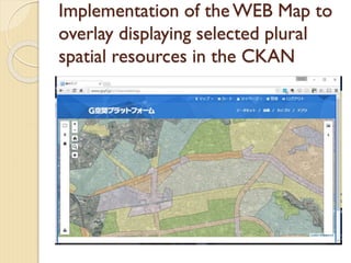
 Implementation of the WEB Map to overlay
displaying selected plural spatial resources in
the CKAN
 Made the ability to purchase application by
selecting the spatial data product with private
companies
Improved the preview function of
spatial data
 Debuged WMS preview
 KML, GeoJSON,CZML
 Use GSI map as Background map
Implementation of the spatial data
processing functions using the
GDAL / OGR
Implementation of the spatial data
processing functions using the
GDAL / OGR
Select Spatial
resource in
CKAN
Select
Processing
method
Specify the
parameters for
the processing
Execute
processing
(GDAL/OGR)
stores the result
in the WEB
public directory
of the server
Send the
results of the URL by
e-mail to the user
Users download
files from a
specified URL
Implementation of the WEB Map to
overlay displaying selected plural
spatial resources in the CKAN
Select spatial resources to display
together then open map
Made the ability to purchase
application by selecting the spatial data
product with private companies
 Some of the private companies in Japan
have sold the spatial data. Such as satellite
image, aerial photos, laser measurement
data, car navigation log, and so the
position of the mobile phone log ,they
sold.
 You can find them in our site.You can also
make a purchase application of their data
Made the ability to purchase
application by selecting the spatial data
product with private companies
select the data you want to buy
adds the selected information to the cart
Create estimates
Future plans
 We are working and trying to the public
of the system this year in November.
 It is also a plan to use paid data of the
private sector in this system
 We are trying to implement a preview
and overlay display of data that varies
with time
I am a member of
the QGIS community
I am a member of
the QGIS community
I want to a little talk about QGIS
We can use the wonderful plug-in
called CKAN browser in QGIS
We can search for CKAN repository
from QGIS With this plug-in
The spatial data in the search have
been CKAN can be used as a layer of
QGIS
I think QGIS is an excellent tool in
order to use such data repository
Thank you for your attention

More Related Content

What's hot

Maps with leafletR
Maps with leafletRMaps with leafletR
Maps with leafletR
Michele Tobias
 
Spatial Computing and the Future of Utility GIS
Spatial Computing and the Future of Utility GISSpatial Computing and the Future of Utility GIS
Spatial Computing and the Future of Utility GIS
George Percivall
 
Data Sources
Data SourcesData Sources
Data Sources
Joe Larson
 
Crowd-Sourcing Approach of Building Ground Truth Database for Global Urban Ar...
Crowd-Sourcing Approach of Building Ground Truth Database for Global Urban Ar...Crowd-Sourcing Approach of Building Ground Truth Database for Global Urban Ar...
Crowd-Sourcing Approach of Building Ground Truth Database for Global Urban Ar...
Hiroyuki Miyazaki
 
Get Big Geo Data
Get Big Geo DataGet Big Geo Data
Get Big Geo Data
Jan Willem van Eck
 
Gisruk2013 addy edit2
Gisruk2013 addy edit2Gisruk2013 addy edit2
Gisruk2013 addy edit2
Addy Pope
 
Paradigm Shift of Geospatial Information Service
Paradigm Shift of Geospatial Information ServiceParadigm Shift of Geospatial Information Service
Paradigm Shift of Geospatial Information Service
SANGHEE SHIN
 
Geolocation analysis using HiveQL
Geolocation analysis using HiveQLGeolocation analysis using HiveQL
Geolocation analysis using HiveQL
Priyanka Kale
 
TYBSC IT SEM 6 GIS
TYBSC IT SEM 6 GISTYBSC IT SEM 6 GIS
TYBSC IT SEM 6 GIS
WE-IT TUTORIALS
 
Hei's urban planning_essay
Hei's urban planning_essayHei's urban planning_essay
Hei's urban planning_essay
lsgi4321
 
Resume 2017
Resume 2017Resume 2017
Resume 2017
Clifton Campbell
 
Introduction to Open Source GIS
Introduction to Open Source GISIntroduction to Open Source GIS
Introduction to Open Source GIS
SANGHEE SHIN
 
Dr Richard Fry - Using R as a GIS
Dr Richard Fry - Using R as a GISDr Richard Fry - Using R as a GIS
Dr Richard Fry - Using R as a GIS
Shaun Lewis
 
NRCS Geospatial Data and Tools
NRCS Geospatial Data and ToolsNRCS Geospatial Data and Tools
VRGeo
VRGeoVRGeo
VRGeo
Prasoon
 
SDSC Technology Forum: Increasing the Impact of High Resolution Topography Da...
SDSC Technology Forum: Increasing the Impact of High Resolution Topography Da...SDSC Technology Forum: Increasing the Impact of High Resolution Topography Da...
SDSC Technology Forum: Increasing the Impact of High Resolution Topography Da...
OpenTopography Facility
 
Big Geo Data: Open Source and Open Standards
Big Geo Data: Open Source and Open StandardsBig Geo Data: Open Source and Open Standards
Big Geo Data: Open Source and Open Standards
George Percivall
 
Using R to Visualize Spatial Data: R as GIS - Guy Lansley
Using R to Visualize Spatial Data: R as GIS - Guy LansleyUsing R to Visualize Spatial Data: R as GIS - Guy Lansley
Using R to Visualize Spatial Data: R as GIS - Guy Lansley
Guy Lansley
 
Connecting River 'Events' to the National Hydrography Dataset (NHD) Using HEM...
Connecting River 'Events' to the National Hydrography Dataset (NHD) Using HEM...Connecting River 'Events' to the National Hydrography Dataset (NHD) Using HEM...
Connecting River 'Events' to the National Hydrography Dataset (NHD) Using HEM...
rshimoda2014
 

What's hot (19)

Maps with leafletR
Maps with leafletRMaps with leafletR
Maps with leafletR
 
Spatial Computing and the Future of Utility GIS
Spatial Computing and the Future of Utility GISSpatial Computing and the Future of Utility GIS
Spatial Computing and the Future of Utility GIS
 
Data Sources
Data SourcesData Sources
Data Sources
 
Crowd-Sourcing Approach of Building Ground Truth Database for Global Urban Ar...
Crowd-Sourcing Approach of Building Ground Truth Database for Global Urban Ar...Crowd-Sourcing Approach of Building Ground Truth Database for Global Urban Ar...
Crowd-Sourcing Approach of Building Ground Truth Database for Global Urban Ar...
 
Get Big Geo Data
Get Big Geo DataGet Big Geo Data
Get Big Geo Data
 
Gisruk2013 addy edit2
Gisruk2013 addy edit2Gisruk2013 addy edit2
Gisruk2013 addy edit2
 
Paradigm Shift of Geospatial Information Service
Paradigm Shift of Geospatial Information ServiceParadigm Shift of Geospatial Information Service
Paradigm Shift of Geospatial Information Service
 
Geolocation analysis using HiveQL
Geolocation analysis using HiveQLGeolocation analysis using HiveQL
Geolocation analysis using HiveQL
 
TYBSC IT SEM 6 GIS
TYBSC IT SEM 6 GISTYBSC IT SEM 6 GIS
TYBSC IT SEM 6 GIS
 
Hei's urban planning_essay
Hei's urban planning_essayHei's urban planning_essay
Hei's urban planning_essay
 
Resume 2017
Resume 2017Resume 2017
Resume 2017
 
Introduction to Open Source GIS
Introduction to Open Source GISIntroduction to Open Source GIS
Introduction to Open Source GIS
 
Dr Richard Fry - Using R as a GIS
Dr Richard Fry - Using R as a GISDr Richard Fry - Using R as a GIS
Dr Richard Fry - Using R as a GIS
 
NRCS Geospatial Data and Tools
NRCS Geospatial Data and ToolsNRCS Geospatial Data and Tools
NRCS Geospatial Data and Tools
 
VRGeo
VRGeoVRGeo
VRGeo
 
SDSC Technology Forum: Increasing the Impact of High Resolution Topography Da...
SDSC Technology Forum: Increasing the Impact of High Resolution Topography Da...SDSC Technology Forum: Increasing the Impact of High Resolution Topography Da...
SDSC Technology Forum: Increasing the Impact of High Resolution Topography Da...
 
Big Geo Data: Open Source and Open Standards
Big Geo Data: Open Source and Open StandardsBig Geo Data: Open Source and Open Standards
Big Geo Data: Open Source and Open Standards
 
Using R to Visualize Spatial Data: R as GIS - Guy Lansley
Using R to Visualize Spatial Data: R as GIS - Guy LansleyUsing R to Visualize Spatial Data: R as GIS - Guy Lansley
Using R to Visualize Spatial Data: R as GIS - Guy Lansley
 
Connecting River 'Events' to the National Hydrography Dataset (NHD) Using HEM...
Connecting River 'Events' to the National Hydrography Dataset (NHD) Using HEM...Connecting River 'Events' to the National Hydrography Dataset (NHD) Using HEM...
Connecting River 'Events' to the National Hydrography Dataset (NHD) Using HEM...
 

Viewers also liked

NaraとOSMとFOSS4G
NaraとOSMとFOSS4GNaraとOSMとFOSS4G
NaraとOSMとFOSS4G
康司 石塚
 
20161030 foss4 g2016_yamakawa
20161030 foss4 g2016_yamakawa20161030 foss4 g2016_yamakawa
20161030 foss4 g2016_yamakawa
OSgeo Japan
 
Open-TD: オープンサイエンス時代の社会協働研究
Open-TD: オープンサイエンス時代の社会協働研究Open-TD: オープンサイエンス時代の社会協働研究
Open-TD: オープンサイエンス時代の社会協働研究
Yasuhisa Kondo
 
FOSS4G と北海道地図
FOSS4G と北海道地図FOSS4G と北海道地図
FOSS4G と北海道地図
Kazutaka ishizaki
 
FOSS4Gと地理院地図
FOSS4Gと地理院地図FOSS4Gと地理院地図
FOSS4Gと地理院地図
OSgeo Japan
 
Foss4 g2016 kansai_v1_a4
Foss4 g2016 kansai_v1_a4Foss4 g2016 kansai_v1_a4
Foss4 g2016 kansai_v1_a4
OSgeo Japan
 
わずか6人の勉強会から200人のカンファレンスに育つまで
わずか6人の勉強会から200人のカンファレンスに育つまでわずか6人の勉強会から200人のカンファレンスに育つまで
わずか6人の勉強会から200人のカンファレンスに育つまで
Yasuto Furukawa
 
さっぽろ保育園マップ~はじめての室蘭編~
さっぽろ保育園マップ~はじめての室蘭編~さっぽろ保育園マップ~はじめての室蘭編~
さっぽろ保育園マップ~はじめての室蘭編~
Mayumit
 
Qgisにおけるラスタデータ解析
Qgisにおけるラスタデータ解析Qgisにおけるラスタデータ解析
Qgisにおけるラスタデータ解析Kazuki Matsumoto
 
市民が護る地域の歴史文化考古資源
市民が護る地域の歴史文化考古資源市民が護る地域の歴史文化考古資源
市民が護る地域の歴史文化考古資源
Junpei Ishii
 
20161119日本図書館研究会wikipedia townaoki
20161119日本図書館研究会wikipedia townaoki20161119日本図書館研究会wikipedia townaoki
20161119日本図書館研究会wikipedia townaoki
和人 青木
 
20140618CKANMeetup_seto
20140618CKANMeetup_seto20140618CKANMeetup_seto
20140618CKANMeetup_setoToshikazu Seto
 
データポータルソフトウェアCKAN
データポータルソフトウェアCKANデータポータルソフトウェアCKAN
データポータルソフトウェアCKAN
Fumihiro Kato
 
140619 地理院ckanの舞台裏から
140619 地理院ckanの舞台裏から140619 地理院ckanの舞台裏から
140619 地理院ckanの舞台裏からHidenori Fujimura
 
2014/06/19 第3回 CKAN コミュニティミーティング | homata
2014/06/19 第3回 CKAN コミュニティミーティング | homata2014/06/19 第3回 CKAN コミュニティミーティング | homata
2014/06/19 第3回 CKAN コミュニティミーティング | homataHiroshi Omata
 
データカタログソフトウェア CKAN
データカタログソフトウェア CKANデータカタログソフトウェア CKAN
データカタログソフトウェア CKAN
Fumihiro Kato
 
千葉市のオープンデータを検索しよう
千葉市のオープンデータを検索しよう千葉市のオープンデータを検索しよう
千葉市のオープンデータを検索しようTomihiko Azuma
 
Code for Japan 勉強会 Vol.1 CKAN入門 プロジェクトのFork、デプロイ、CIまで
Code for Japan 勉強会 Vol.1 CKAN入門 プロジェクトのFork、デプロイ、CIまでCode for Japan 勉強会 Vol.1 CKAN入門 プロジェクトのFork、デプロイ、CIまで
Code for Japan 勉強会 Vol.1 CKAN入門 プロジェクトのFork、デプロイ、CIまで
Naoyuki Yamada
 
TileMap-WebGIS
TileMap-WebGISTileMap-WebGIS
TileMap-WebGIS
IWASAKI NOBUSUKE
 
FOSS4Gで地理院地図
FOSS4Gで地理院地図FOSS4Gで地理院地図
FOSS4Gで地理院地図
Hidenori Fujimura
 

Viewers also liked (20)

NaraとOSMとFOSS4G
NaraとOSMとFOSS4GNaraとOSMとFOSS4G
NaraとOSMとFOSS4G
 
20161030 foss4 g2016_yamakawa
20161030 foss4 g2016_yamakawa20161030 foss4 g2016_yamakawa
20161030 foss4 g2016_yamakawa
 
Open-TD: オープンサイエンス時代の社会協働研究
Open-TD: オープンサイエンス時代の社会協働研究Open-TD: オープンサイエンス時代の社会協働研究
Open-TD: オープンサイエンス時代の社会協働研究
 
FOSS4G と北海道地図
FOSS4G と北海道地図FOSS4G と北海道地図
FOSS4G と北海道地図
 
FOSS4Gと地理院地図
FOSS4Gと地理院地図FOSS4Gと地理院地図
FOSS4Gと地理院地図
 
Foss4 g2016 kansai_v1_a4
Foss4 g2016 kansai_v1_a4Foss4 g2016 kansai_v1_a4
Foss4 g2016 kansai_v1_a4
 
わずか6人の勉強会から200人のカンファレンスに育つまで
わずか6人の勉強会から200人のカンファレンスに育つまでわずか6人の勉強会から200人のカンファレンスに育つまで
わずか6人の勉強会から200人のカンファレンスに育つまで
 
さっぽろ保育園マップ~はじめての室蘭編~
さっぽろ保育園マップ~はじめての室蘭編~さっぽろ保育園マップ~はじめての室蘭編~
さっぽろ保育園マップ~はじめての室蘭編~
 
Qgisにおけるラスタデータ解析
Qgisにおけるラスタデータ解析Qgisにおけるラスタデータ解析
Qgisにおけるラスタデータ解析
 
市民が護る地域の歴史文化考古資源
市民が護る地域の歴史文化考古資源市民が護る地域の歴史文化考古資源
市民が護る地域の歴史文化考古資源
 
20161119日本図書館研究会wikipedia townaoki
20161119日本図書館研究会wikipedia townaoki20161119日本図書館研究会wikipedia townaoki
20161119日本図書館研究会wikipedia townaoki
 
20140618CKANMeetup_seto
20140618CKANMeetup_seto20140618CKANMeetup_seto
20140618CKANMeetup_seto
 
データポータルソフトウェアCKAN
データポータルソフトウェアCKANデータポータルソフトウェアCKAN
データポータルソフトウェアCKAN
 
140619 地理院ckanの舞台裏から
140619 地理院ckanの舞台裏から140619 地理院ckanの舞台裏から
140619 地理院ckanの舞台裏から
 
2014/06/19 第3回 CKAN コミュニティミーティング | homata
2014/06/19 第3回 CKAN コミュニティミーティング | homata2014/06/19 第3回 CKAN コミュニティミーティング | homata
2014/06/19 第3回 CKAN コミュニティミーティング | homata
 
データカタログソフトウェア CKAN
データカタログソフトウェア CKANデータカタログソフトウェア CKAN
データカタログソフトウェア CKAN
 
千葉市のオープンデータを検索しよう
千葉市のオープンデータを検索しよう千葉市のオープンデータを検索しよう
千葉市のオープンデータを検索しよう
 
Code for Japan 勉強会 Vol.1 CKAN入門 プロジェクトのFork、デプロイ、CIまで
Code for Japan 勉強会 Vol.1 CKAN入門 プロジェクトのFork、デプロイ、CIまでCode for Japan 勉強会 Vol.1 CKAN入門 プロジェクトのFork、デプロイ、CIまで
Code for Japan 勉強会 Vol.1 CKAN入門 プロジェクトのFork、デプロイ、CIまで
 
TileMap-WebGIS
TileMap-WebGISTileMap-WebGIS
TileMap-WebGIS
 
FOSS4Gで地理院地図
FOSS4Gで地理院地図FOSS4Gで地理院地図
FOSS4Gで地理院地図
 

Similar to CKANへの空間情報機能拡張実装の試み

Introduction to KAOS-G(FOSS4G Asia 2014)
Introduction to KAOS-G(FOSS4G Asia 2014)Introduction to KAOS-G(FOSS4G Asia 2014)
Introduction to KAOS-G(FOSS4G Asia 2014)
slhead1
 
Introduction to KAOS-G at FOSS4G Osaka 2013
Introduction to KAOS-G at FOSS4G Osaka 2013Introduction to KAOS-G at FOSS4G Osaka 2013
Introduction to KAOS-G at FOSS4G Osaka 2013
slhead1
 
Open Source based GIS devlopment cases by Gaia3D_20150417
Open Source based GIS devlopment cases by Gaia3D_20150417Open Source based GIS devlopment cases by Gaia3D_20150417
Open Source based GIS devlopment cases by Gaia3D_20150417
BJ Jang
 
Pt foss4 g osaka 2014 v05
Pt foss4 g osaka 2014 v05Pt foss4 g osaka 2014 v05
Pt foss4 g osaka 2014 v05
KimKyeongryong
 
Introduction to OpenIndoorMap
Introduction to OpenIndoorMapIntroduction to OpenIndoorMap
Introduction to OpenIndoorMap
SANGHEE SHIN
 
Use of Open Data in Hong Kong
Use of Open Data in Hong KongUse of Open Data in Hong Kong
Use of Open Data in Hong Kong
Sammy Fung
 
Enrichment of Geoportal Interoperable Platform and Development of Thematic Ap...
Enrichment of Geoportal Interoperable Platform and Development of Thematic Ap...Enrichment of Geoportal Interoperable Platform and Development of Thematic Ap...
Enrichment of Geoportal Interoperable Platform and Development of Thematic Ap...
IRJET Journal
 
React’s suitability to develop Geospatial solutions.pdf
React’s suitability to develop Geospatial solutions.pdfReact’s suitability to develop Geospatial solutions.pdf
React’s suitability to develop Geospatial solutions.pdf
Mindfire LLC
 
Spatial Data Infrastructure Best Practices with GeoNode
Spatial Data Infrastructure Best Practices with GeoNodeSpatial Data Infrastructure Best Practices with GeoNode
Spatial Data Infrastructure Best Practices with GeoNode
Sebastian Benthall
 
The State of GIS in Washington & Oregon The 2014 GMI Metric Survey
The State of GIS in Washington & Oregon  The 2014 GMI Metric SurveyThe State of GIS in Washington & Oregon  The 2014 GMI Metric Survey
The State of GIS in Washington & Oregon The 2014 GMI Metric Survey
Greg Babinski
 
Use of Open Data in Hong Kong (LegCo 2014)
Use of Open Data in Hong Kong (LegCo 2014)Use of Open Data in Hong Kong (LegCo 2014)
Use of Open Data in Hong Kong (LegCo 2014)
Sammy Fung
 
React’s suitability to develop Geospatial solutions.pdf
React’s suitability to develop Geospatial solutions.pdfReact’s suitability to develop Geospatial solutions.pdf
React’s suitability to develop Geospatial solutions.pdf
Mindfire LLC
 
02 -how-will-inspire-influence-local-authorities-and-spatial-planning
02 -how-will-inspire-influence-local-authorities-and-spatial-planning02 -how-will-inspire-influence-local-authorities-and-spatial-planning
02 -how-will-inspire-influence-local-authorities-and-spatial-planning
Karel Charvat
 
OGD India Journey, 2012 - 2017
OGD India  Journey, 2012 - 2017OGD India  Journey, 2012 - 2017
OGD India Journey, 2012 - 2017
Data Portal India
 
Ijetr042136
Ijetr042136Ijetr042136
OAP Presentation
OAP PresentationOAP Presentation
OAP Presentation
Ashwin Swamy
 
AAG panel discussion on great lakes africa
AAG panel discussion on great lakes africaAAG panel discussion on great lakes africa
AAG panel discussion on great lakes africa
Decision and Policy Analysis Program
 
Use of Open Source in Education Sector.pptx
Use of Open Source in Education Sector.pptxUse of Open Source in Education Sector.pptx
Use of Open Source in Education Sector.pptx
swaranjaggi
 
Topic15 GeoInfoMap by 10525309D
Topic15 GeoInfoMap by 10525309DTopic15 GeoInfoMap by 10525309D
Topic15 GeoInfoMap by 10525309D
lsgi4321
 
UGIC 2009 Conference
UGIC 2009 ConferenceUGIC 2009 Conference
UGIC 2009 Conference
Wansoo Im
 

Similar to CKANへの空間情報機能拡張実装の試み (20)

Introduction to KAOS-G(FOSS4G Asia 2014)
Introduction to KAOS-G(FOSS4G Asia 2014)Introduction to KAOS-G(FOSS4G Asia 2014)
Introduction to KAOS-G(FOSS4G Asia 2014)
 
Introduction to KAOS-G at FOSS4G Osaka 2013
Introduction to KAOS-G at FOSS4G Osaka 2013Introduction to KAOS-G at FOSS4G Osaka 2013
Introduction to KAOS-G at FOSS4G Osaka 2013
 
Open Source based GIS devlopment cases by Gaia3D_20150417
Open Source based GIS devlopment cases by Gaia3D_20150417Open Source based GIS devlopment cases by Gaia3D_20150417
Open Source based GIS devlopment cases by Gaia3D_20150417
 
Pt foss4 g osaka 2014 v05
Pt foss4 g osaka 2014 v05Pt foss4 g osaka 2014 v05
Pt foss4 g osaka 2014 v05
 
Introduction to OpenIndoorMap
Introduction to OpenIndoorMapIntroduction to OpenIndoorMap
Introduction to OpenIndoorMap
 
Use of Open Data in Hong Kong
Use of Open Data in Hong KongUse of Open Data in Hong Kong
Use of Open Data in Hong Kong
 
Enrichment of Geoportal Interoperable Platform and Development of Thematic Ap...
Enrichment of Geoportal Interoperable Platform and Development of Thematic Ap...Enrichment of Geoportal Interoperable Platform and Development of Thematic Ap...
Enrichment of Geoportal Interoperable Platform and Development of Thematic Ap...
 
React’s suitability to develop Geospatial solutions.pdf
React’s suitability to develop Geospatial solutions.pdfReact’s suitability to develop Geospatial solutions.pdf
React’s suitability to develop Geospatial solutions.pdf
 
Spatial Data Infrastructure Best Practices with GeoNode
Spatial Data Infrastructure Best Practices with GeoNodeSpatial Data Infrastructure Best Practices with GeoNode
Spatial Data Infrastructure Best Practices with GeoNode
 
The State of GIS in Washington & Oregon The 2014 GMI Metric Survey
The State of GIS in Washington & Oregon  The 2014 GMI Metric SurveyThe State of GIS in Washington & Oregon  The 2014 GMI Metric Survey
The State of GIS in Washington & Oregon The 2014 GMI Metric Survey
 
Use of Open Data in Hong Kong (LegCo 2014)
Use of Open Data in Hong Kong (LegCo 2014)Use of Open Data in Hong Kong (LegCo 2014)
Use of Open Data in Hong Kong (LegCo 2014)
 
React’s suitability to develop Geospatial solutions.pdf
React’s suitability to develop Geospatial solutions.pdfReact’s suitability to develop Geospatial solutions.pdf
React’s suitability to develop Geospatial solutions.pdf
 
02 -how-will-inspire-influence-local-authorities-and-spatial-planning
02 -how-will-inspire-influence-local-authorities-and-spatial-planning02 -how-will-inspire-influence-local-authorities-and-spatial-planning
02 -how-will-inspire-influence-local-authorities-and-spatial-planning
 
OGD India Journey, 2012 - 2017
OGD India  Journey, 2012 - 2017OGD India  Journey, 2012 - 2017
OGD India Journey, 2012 - 2017
 
Ijetr042136
Ijetr042136Ijetr042136
Ijetr042136
 
OAP Presentation
OAP PresentationOAP Presentation
OAP Presentation
 
AAG panel discussion on great lakes africa
AAG panel discussion on great lakes africaAAG panel discussion on great lakes africa
AAG panel discussion on great lakes africa
 
Use of Open Source in Education Sector.pptx
Use of Open Source in Education Sector.pptxUse of Open Source in Education Sector.pptx
Use of Open Source in Education Sector.pptx
 
Topic15 GeoInfoMap by 10525309D
Topic15 GeoInfoMap by 10525309DTopic15 GeoInfoMap by 10525309D
Topic15 GeoInfoMap by 10525309D
 
UGIC 2009 Conference
UGIC 2009 ConferenceUGIC 2009 Conference
UGIC 2009 Conference
 

More from Yoichi Kayama

スマートフォンを利用した災害時情報収集システムの開発
スマートフォンを利用した災害時情報収集システムの開発スマートフォンを利用した災害時情報収集システムの開発
スマートフォンを利用した災害時情報収集システムの開発
Yoichi Kayama
 
Google Spread sheetを利用した地理空間情報フレームワークの開発
Google Spread sheetを利用した地理空間情報フレームワークの開発Google Spread sheetを利用した地理空間情報フレームワークの開発
Google Spread sheetを利用した地理空間情報フレームワークの開発
Yoichi Kayama
 
Development of disaster information collection system using chatbot
Development of disaster information collection system using chatbot Development of disaster information collection system using chatbot
Development of disaster information collection system using chatbot
Yoichi Kayama
 
Foss4 g2019toilet search_chatbot
Foss4 g2019toilet search_chatbotFoss4 g2019toilet search_chatbot
Foss4 g2019toilet search_chatbot
Yoichi Kayama
 
Current status and_issues_of_qgis_japanese_localization_gisa2014
Current status and_issues_of_qgis_japanese_localization_gisa2014Current status and_issues_of_qgis_japanese_localization_gisa2014
Current status and_issues_of_qgis_japanese_localization_gisa2014
Yoichi Kayama
 
FOSS4G OSAKAライトニングトーク
FOSS4G OSAKAライトニングトークFOSS4G OSAKAライトニングトーク
FOSS4G OSAKAライトニングトーク
Yoichi Kayama
 
QGIS2.0の登場とFOSS4Gの新展開
QGIS2.0の登場とFOSS4Gの新展開QGIS2.0の登場とFOSS4Gの新展開
QGIS2.0の登場とFOSS4Gの新展開
Yoichi Kayama
 
QGIS training 2/3
QGIS training 2/3QGIS training 2/3
QGIS training 2/3
Yoichi Kayama
 
QGIS training 1/3
QGIS training 1/3QGIS training 1/3
QGIS training 1/3
Yoichi Kayama
 
A new generation Geospatial information use environment driven by open data ...
A new generation  Geospatial information use environment driven by open data ...A new generation  Geospatial information use environment driven by open data ...
A new generation Geospatial information use environment driven by open data ...
Yoichi Kayama
 
QGISローカライズの現状と課題
QGISローカライズの現状と課題QGISローカライズの現状と課題
QGISローカライズの現状と課題
Yoichi Kayama
 
SoTM2012 Tokyo presentation
SoTM2012 Tokyo presentation SoTM2012 Tokyo presentation
SoTM2012 Tokyo presentation
Yoichi Kayama
 
被災者の行政手続きにおける地図情報の活用とAPIの利用
被災者の行政手続きにおける地図情報の活用とAPIの利用被災者の行政手続きにおける地図情報の活用とAPIの利用
被災者の行政手続きにおける地図情報の活用とAPIの利用
Yoichi Kayama
 
QGIS応用操作.
QGIS応用操作.QGIS応用操作.
QGIS応用操作.
Yoichi Kayama
 
QGIS基本操作.
QGIS基本操作.QGIS基本操作.
QGIS基本操作.
Yoichi Kayama
 
地理空間情報分野のOSSの動向と活用事例.
地理空間情報分野のOSSの動向と活用事例.地理空間情報分野のOSSの動向と活用事例.
地理空間情報分野のOSSの動向と活用事例.
Yoichi Kayama
 
自由な空間情報利用のためのツールQGISと日本語化プロジェクトの紹介
自由な空間情報利用のためのツールQGISと日本語化プロジェクトの紹介自由な空間情報利用のためのツールQGISと日本語化プロジェクトの紹介
自由な空間情報利用のためのツールQGISと日本語化プロジェクトの紹介
Yoichi Kayama
 
Introduction of flood evacuation route search system using QGIS,PostGIS,GRASS...
Introduction of flood evacuation route search system using QGIS,PostGIS,GRASS...Introduction of flood evacuation route search system using QGIS,PostGIS,GRASS...
Introduction of flood evacuation route search system using QGIS,PostGIS,GRASS...
Yoichi Kayama
 
QuantumGISを使ったPostgreSQL/PostGIS利用方法紹介
QuantumGISを使ったPostgreSQL/PostGIS利用方法紹介QuantumGISを使ったPostgreSQL/PostGIS利用方法紹介
QuantumGISを使ったPostgreSQL/PostGIS利用方法紹介
Yoichi Kayama
 
FOSS4Gを利用した水害時避難経路検索システムの構築
FOSS4Gを利用した水害時避難経路検索システムの構築FOSS4Gを利用した水害時避難経路検索システムの構築
FOSS4Gを利用した水害時避難経路検索システムの構築Yoichi Kayama
 

More from Yoichi Kayama (20)

スマートフォンを利用した災害時情報収集システムの開発
スマートフォンを利用した災害時情報収集システムの開発スマートフォンを利用した災害時情報収集システムの開発
スマートフォンを利用した災害時情報収集システムの開発
 
Google Spread sheetを利用した地理空間情報フレームワークの開発
Google Spread sheetを利用した地理空間情報フレームワークの開発Google Spread sheetを利用した地理空間情報フレームワークの開発
Google Spread sheetを利用した地理空間情報フレームワークの開発
 
Development of disaster information collection system using chatbot
Development of disaster information collection system using chatbot Development of disaster information collection system using chatbot
Development of disaster information collection system using chatbot
 
Foss4 g2019toilet search_chatbot
Foss4 g2019toilet search_chatbotFoss4 g2019toilet search_chatbot
Foss4 g2019toilet search_chatbot
 
Current status and_issues_of_qgis_japanese_localization_gisa2014
Current status and_issues_of_qgis_japanese_localization_gisa2014Current status and_issues_of_qgis_japanese_localization_gisa2014
Current status and_issues_of_qgis_japanese_localization_gisa2014
 
FOSS4G OSAKAライトニングトーク
FOSS4G OSAKAライトニングトークFOSS4G OSAKAライトニングトーク
FOSS4G OSAKAライトニングトーク
 
QGIS2.0の登場とFOSS4Gの新展開
QGIS2.0の登場とFOSS4Gの新展開QGIS2.0の登場とFOSS4Gの新展開
QGIS2.0の登場とFOSS4Gの新展開
 
QGIS training 2/3
QGIS training 2/3QGIS training 2/3
QGIS training 2/3
 
QGIS training 1/3
QGIS training 1/3QGIS training 1/3
QGIS training 1/3
 
A new generation Geospatial information use environment driven by open data ...
A new generation  Geospatial information use environment driven by open data ...A new generation  Geospatial information use environment driven by open data ...
A new generation Geospatial information use environment driven by open data ...
 
QGISローカライズの現状と課題
QGISローカライズの現状と課題QGISローカライズの現状と課題
QGISローカライズの現状と課題
 
SoTM2012 Tokyo presentation
SoTM2012 Tokyo presentation SoTM2012 Tokyo presentation
SoTM2012 Tokyo presentation
 
被災者の行政手続きにおける地図情報の活用とAPIの利用
被災者の行政手続きにおける地図情報の活用とAPIの利用被災者の行政手続きにおける地図情報の活用とAPIの利用
被災者の行政手続きにおける地図情報の活用とAPIの利用
 
QGIS応用操作.
QGIS応用操作.QGIS応用操作.
QGIS応用操作.
 
QGIS基本操作.
QGIS基本操作.QGIS基本操作.
QGIS基本操作.
 
地理空間情報分野のOSSの動向と活用事例.
地理空間情報分野のOSSの動向と活用事例.地理空間情報分野のOSSの動向と活用事例.
地理空間情報分野のOSSの動向と活用事例.
 
自由な空間情報利用のためのツールQGISと日本語化プロジェクトの紹介
自由な空間情報利用のためのツールQGISと日本語化プロジェクトの紹介自由な空間情報利用のためのツールQGISと日本語化プロジェクトの紹介
自由な空間情報利用のためのツールQGISと日本語化プロジェクトの紹介
 
Introduction of flood evacuation route search system using QGIS,PostGIS,GRASS...
Introduction of flood evacuation route search system using QGIS,PostGIS,GRASS...Introduction of flood evacuation route search system using QGIS,PostGIS,GRASS...
Introduction of flood evacuation route search system using QGIS,PostGIS,GRASS...
 
QuantumGISを使ったPostgreSQL/PostGIS利用方法紹介
QuantumGISを使ったPostgreSQL/PostGIS利用方法紹介QuantumGISを使ったPostgreSQL/PostGIS利用方法紹介
QuantumGISを使ったPostgreSQL/PostGIS利用方法紹介
 
FOSS4Gを利用した水害時避難経路検索システムの構築
FOSS4Gを利用した水害時避難経路検索システムの構築FOSS4Gを利用した水害時避難経路検索システムの構築
FOSS4Gを利用した水害時避難経路検索システムの構築
 

Recently uploaded

Best Immigration Consultants in Amritsar- SAGA Studies
Best Immigration Consultants in Amritsar- SAGA StudiesBest Immigration Consultants in Amritsar- SAGA Studies
Best Immigration Consultants in Amritsar- SAGA Studies
SAGA Studies
 
DOJO Training room | Training DOJO PPT
DOJO Training room | Training DOJO   PPTDOJO Training room | Training DOJO   PPT
DOJO Training room | Training DOJO PPT
Himanshu
 
3 Examples of new capital gains taxes in Canada
3 Examples of new capital gains taxes in Canada3 Examples of new capital gains taxes in Canada
3 Examples of new capital gains taxes in Canada
Lakshay Gandhi
 
Enhance Your Home with Professional Painting Services
Enhance Your Home with Professional Painting ServicesEnhance Your Home with Professional Painting Services
Enhance Your Home with Professional Painting Services
Perfect Industrial
 
Siddhivinayak temple timings Houston, TX
Siddhivinayak temple timings Houston, TXSiddhivinayak temple timings Houston, TX
Siddhivinayak temple timings Houston, TX
gaurisiddhivinayakte
 
Exceptional Landscape Architecture Services in Melbourne
Exceptional Landscape Architecture Services in MelbourneExceptional Landscape Architecture Services in Melbourne
Exceptional Landscape Architecture Services in Melbourne
Outdoor Home Decor Company
 
Electrical Testing Lab Services in Dubai.pdf
Electrical Testing Lab Services in Dubai.pdfElectrical Testing Lab Services in Dubai.pdf
Electrical Testing Lab Services in Dubai.pdf
sandeepmetsuae
 
antivirus and security software | basics
antivirus and security software | basicsantivirus and security software | basics
antivirus and security software | basics
basicsprotection
 
How Do Love Spells Really Work? The Secret to Get Your Ex Back Fast, Powerful...
How Do Love Spells Really Work? The Secret to Get Your Ex Back Fast, Powerful...How Do Love Spells Really Work? The Secret to Get Your Ex Back Fast, Powerful...
How Do Love Spells Really Work? The Secret to Get Your Ex Back Fast, Powerful...
Traditional Healer, Love Spells Caster and Money Spells That Work Fast
 
Discover How Long Do Aluminum Gutters Last?
Discover How Long Do Aluminum Gutters Last?Discover How Long Do Aluminum Gutters Last?
Discover How Long Do Aluminum Gutters Last?
SteveRiddle8
 
Generate Revenue with Contact Center Business Model Strategy
Generate Revenue with Contact Center Business Model StrategyGenerate Revenue with Contact Center Business Model Strategy
Generate Revenue with Contact Center Business Model Strategy
RNayak3
 
How Long Does Vinyl Siding Last and What Impacts Its Life Expectancy?
How Long Does Vinyl Siding Last and What Impacts Its Life Expectancy?How Long Does Vinyl Siding Last and What Impacts Its Life Expectancy?
How Long Does Vinyl Siding Last and What Impacts Its Life Expectancy?
Alexa Bale
 
Understanding Love Compatibility or Synastry: Why It Matters
Understanding Love Compatibility or Synastry: Why It MattersUnderstanding Love Compatibility or Synastry: Why It Matters
Understanding Love Compatibility or Synastry: Why It Matters
AstroForYou
 
Top Challenges Faced by High-Risk Merchants and How to Overcome Them.pptx
Top Challenges Faced by High-Risk Merchants and How to Overcome Them.pptxTop Challenges Faced by High-Risk Merchants and How to Overcome Them.pptx
Top Challenges Faced by High-Risk Merchants and How to Overcome Them.pptx
Merchantech - Payment Processing Services
 
The Fraud Examiner’s Report – What the Certified Fraud Examiner Should Know
The Fraud Examiner’s Report –  What the Certified Fraud Examiner Should KnowThe Fraud Examiner’s Report –  What the Certified Fraud Examiner Should Know
The Fraud Examiner’s Report – What the Certified Fraud Examiner Should Know
Godwin Emmanuel Oyedokun MBA MSc PhD FCA FCTI FCNA CFE FFAR
 
Electrical Testing Lab Services in Dubai.pptx
Electrical Testing Lab Services in Dubai.pptxElectrical Testing Lab Services in Dubai.pptx
Electrical Testing Lab Services in Dubai.pptx
sandeepmetsuae
 
Biomass Briquettes A Sustainable Solution for Energy and Waste Management..pptx
Biomass Briquettes A Sustainable Solution for Energy and Waste Management..pptxBiomass Briquettes A Sustainable Solution for Energy and Waste Management..pptx
Biomass Briquettes A Sustainable Solution for Energy and Waste Management..pptx
ECOSTAN Biofuel Pvt Ltd
 
Material Testing Lab Services in Dubai.pptx
Material Testing Lab Services in Dubai.pptxMaterial Testing Lab Services in Dubai.pptx
Material Testing Lab Services in Dubai.pptx
sandeepmetsuae
 
Best Web Development Frameworks in 2024
Best Web Development Frameworks in 2024Best Web Development Frameworks in 2024
Best Web Development Frameworks in 2024
growthgrids
 
Top 10 Challenges That Every Web Designer Face on A Daily Basis.pptx
Top 10 Challenges That Every Web Designer Face on A Daily Basis.pptxTop 10 Challenges That Every Web Designer Face on A Daily Basis.pptx
Top 10 Challenges That Every Web Designer Face on A Daily Basis.pptx
e-Definers Technology
 

Recently uploaded (20)

Best Immigration Consultants in Amritsar- SAGA Studies
Best Immigration Consultants in Amritsar- SAGA StudiesBest Immigration Consultants in Amritsar- SAGA Studies
Best Immigration Consultants in Amritsar- SAGA Studies
 
DOJO Training room | Training DOJO PPT
DOJO Training room | Training DOJO   PPTDOJO Training room | Training DOJO   PPT
DOJO Training room | Training DOJO PPT
 
3 Examples of new capital gains taxes in Canada
3 Examples of new capital gains taxes in Canada3 Examples of new capital gains taxes in Canada
3 Examples of new capital gains taxes in Canada
 
Enhance Your Home with Professional Painting Services
Enhance Your Home with Professional Painting ServicesEnhance Your Home with Professional Painting Services
Enhance Your Home with Professional Painting Services
 
Siddhivinayak temple timings Houston, TX
Siddhivinayak temple timings Houston, TXSiddhivinayak temple timings Houston, TX
Siddhivinayak temple timings Houston, TX
 
Exceptional Landscape Architecture Services in Melbourne
Exceptional Landscape Architecture Services in MelbourneExceptional Landscape Architecture Services in Melbourne
Exceptional Landscape Architecture Services in Melbourne
 
Electrical Testing Lab Services in Dubai.pdf
Electrical Testing Lab Services in Dubai.pdfElectrical Testing Lab Services in Dubai.pdf
Electrical Testing Lab Services in Dubai.pdf
 
antivirus and security software | basics
antivirus and security software | basicsantivirus and security software | basics
antivirus and security software | basics
 
How Do Love Spells Really Work? The Secret to Get Your Ex Back Fast, Powerful...
How Do Love Spells Really Work? The Secret to Get Your Ex Back Fast, Powerful...How Do Love Spells Really Work? The Secret to Get Your Ex Back Fast, Powerful...
How Do Love Spells Really Work? The Secret to Get Your Ex Back Fast, Powerful...
 
Discover How Long Do Aluminum Gutters Last?
Discover How Long Do Aluminum Gutters Last?Discover How Long Do Aluminum Gutters Last?
Discover How Long Do Aluminum Gutters Last?
 
Generate Revenue with Contact Center Business Model Strategy
Generate Revenue with Contact Center Business Model StrategyGenerate Revenue with Contact Center Business Model Strategy
Generate Revenue with Contact Center Business Model Strategy
 
How Long Does Vinyl Siding Last and What Impacts Its Life Expectancy?
How Long Does Vinyl Siding Last and What Impacts Its Life Expectancy?How Long Does Vinyl Siding Last and What Impacts Its Life Expectancy?
How Long Does Vinyl Siding Last and What Impacts Its Life Expectancy?
 
Understanding Love Compatibility or Synastry: Why It Matters
Understanding Love Compatibility or Synastry: Why It MattersUnderstanding Love Compatibility or Synastry: Why It Matters
Understanding Love Compatibility or Synastry: Why It Matters
 
Top Challenges Faced by High-Risk Merchants and How to Overcome Them.pptx
Top Challenges Faced by High-Risk Merchants and How to Overcome Them.pptxTop Challenges Faced by High-Risk Merchants and How to Overcome Them.pptx
Top Challenges Faced by High-Risk Merchants and How to Overcome Them.pptx
 
The Fraud Examiner’s Report – What the Certified Fraud Examiner Should Know
The Fraud Examiner’s Report –  What the Certified Fraud Examiner Should KnowThe Fraud Examiner’s Report –  What the Certified Fraud Examiner Should Know
The Fraud Examiner’s Report – What the Certified Fraud Examiner Should Know
 
Electrical Testing Lab Services in Dubai.pptx
Electrical Testing Lab Services in Dubai.pptxElectrical Testing Lab Services in Dubai.pptx
Electrical Testing Lab Services in Dubai.pptx
 
Biomass Briquettes A Sustainable Solution for Energy and Waste Management..pptx
Biomass Briquettes A Sustainable Solution for Energy and Waste Management..pptxBiomass Briquettes A Sustainable Solution for Energy and Waste Management..pptx
Biomass Briquettes A Sustainable Solution for Energy and Waste Management..pptx
 
Material Testing Lab Services in Dubai.pptx
Material Testing Lab Services in Dubai.pptxMaterial Testing Lab Services in Dubai.pptx
Material Testing Lab Services in Dubai.pptx
 
Best Web Development Frameworks in 2024
Best Web Development Frameworks in 2024Best Web Development Frameworks in 2024
Best Web Development Frameworks in 2024
 
Top 10 Challenges That Every Web Designer Face on A Daily Basis.pptx
Top 10 Challenges That Every Web Designer Face on A Daily Basis.pptxTop 10 Challenges That Every Web Designer Face on A Daily Basis.pptx
Top 10 Challenges That Every Web Designer Face on A Daily Basis.pptx
 

CKANへの空間情報機能拡張実装の試み