SlideShare a Scribd company logo
1 of 1
Field Data Collecting, Processing and Sharing:
Using web Service Technologies
Niroshan Bandara*, Venkatesh Raghavan*, Daisuke Yoshida*, Gerald Fenoy**
*Osaka City University, Japan
**GeoLabs sarl, France
INTRODUCTION
Collecting, Distributing and Analyzing field data is a crucial part in any geospatial
study. Field data collection tools and methods have been developed significantly
due to the advancement of technologies such as Global Navigational Satellite
Systems (GNSS) and development of smartphones. Accurate field data collection
is also a necessary task for broad spatial data analysis and proper decision
making. Development of Web technologies led to share the data and information
effectively. This study tries to develop a framework based on the Geospatial
Semantic Web technologies for disseminating and processing field data.
Experimental results from an implemented prototype show that the proposed
framework allows to visualize and process the field data in any context. The
system of this study is capable of distributing and processing field data using web
application. Moreover, the study demonstrates the importance and the capabilities
of web services for spatial data gathering and processing. The system has been
developed based on Free and Open Source Software (FOSS) packages such as
ZOO-Project, Open Data Kit, etc. It enables user to further improve or deploy the
system for variety of studies.
COMPONENTS
Main components of the project can be categorized as Mobile data collection
applications and GIS applications concerning Desktop and Web.
1 2 3
2. QGIS
QGIS is a user friendly Open Source GIS software package which can import
layesr locally and online from a server as a service such as WFS, WMS. And QGIS
has capabilities to manipulate various types of spatial data formats such as KML,
SVG, GeoTIFF, GeoJSON, PostGIS, SpatiaLite, MSSQL, etc.
1. ZOO-Project
ZOO-Project is an Open Source Geospatial (OSGeo) Foundation project that
enables existing open source libraries to interact through its WPS framework. It
consists with three components as describe below;
ARCHITECTURE
Users can exploit their mobile devices to record field data using ODK suite. The
data will be sent to ODK Aggregate, which is running on an Apache Tomcat server
backed with a PostgreSQL database. Then the data is published through the
GeoServer. Finally data can be visualized using web viewer or it can be processed
by ZOO-Project as WPS or QGIS as desktop client.
WPS
XLS Forms
Convert
Database
WMS WFS
ODK COLLECT
Desktop GIS
Web viewer
Web GIS
application
Client side Server side
AGGREGATE
DATA VISUALIZATION
Data Visualization; (a) View submission; (b) Web viewer
(a) (b)
DATA COLLECTION
Data are collected by using ODK collect. The application let the user to insert the
GPS location automatically. And other data such as multimedia and text/numbers
can be entered manually.
ODK Collect; (a) Survey forms; (b) GPS information; (c) Input Images; (d) Additional data inputs
(a) (b) (c) (d)
As web processing
Data imports to QGIS and process ; (a) Import from PosrgreSQL database; (b) Import as WFS (c) Analyse in QGIS
Web processing interface; (a) Data points; (b) Result after processing
As desktop client
DATA PROCESS
(a) (b) (c)
(a) (b)
CONCLUSION
Advancement of Mobile phone and Web technologies has been able to simplify the spatial analysis and field data collection. Barriers and gaps in the geospatial science
can be truly addressed by developing such systems.
ZOO service
ZOO API
ZOO Kernel
• Code – C, Python, java, Perl, JavaScript
• .zcfg – zoo configuration file
• JS script – for WPS chaining
• Classes – zoo request, zoo process, etc
WPS Engine
OpenLayers | UDIG | Your Client
WPS Client
3. Open Data Kit
ODK consists of three modules as shown below:
Aggregate
ODK Build is used to
create and design the field
survey forms.
ODK Aggregate is server-
side module which
provides blank forms to
ODK collect and work as a
data repository.
ODK collect is the client-
side module and it is an
app which can be installed
on the Android mobiles.
FOSS4G 2016 NARA.KANSAI

More Related Content

What's hot

Gisruk2013 addy edit2
Gisruk2013 addy edit2Gisruk2013 addy edit2
Gisruk2013 addy edit2Addy Pope
 
Spatial Computing and the Future of Utility GIS
Spatial Computing and the Future of Utility GISSpatial Computing and the Future of Utility GIS
Spatial Computing and the Future of Utility GISGeorge Percivall
 
Crowd-Sourcing Approach of Building Ground Truth Database for Global Urban Ar...
Crowd-Sourcing Approach of Building Ground Truth Database for Global Urban Ar...Crowd-Sourcing Approach of Building Ground Truth Database for Global Urban Ar...
Crowd-Sourcing Approach of Building Ground Truth Database for Global Urban Ar...Hiroyuki Miyazaki
 
Paradigm Shift of Geospatial Information Service
Paradigm Shift of Geospatial Information ServiceParadigm Shift of Geospatial Information Service
Paradigm Shift of Geospatial Information ServiceSANGHEE SHIN
 
Web-GIS Based Utility Management System
Web-GIS Based Utility Management SystemWeb-GIS Based Utility Management System
Web-GIS Based Utility Management SystemRabin Ojha
 
Geolocation analysis using HiveQL
Geolocation analysis using HiveQLGeolocation analysis using HiveQL
Geolocation analysis using HiveQLPriyanka Kale
 
Creating gridded cartograms: Israel and the Palestine Territories
Creating gridded cartograms: Israel and the Palestine TerritoriesCreating gridded cartograms: Israel and the Palestine Territories
Creating gridded cartograms: Israel and the Palestine TerritoriesBenjamin Hennig
 
Big Geo Data: Open Source and Open Standards
Big Geo Data: Open Source and Open StandardsBig Geo Data: Open Source and Open Standards
Big Geo Data: Open Source and Open StandardsGeorge Percivall
 
Introduction to Open Source GIS
Introduction to Open Source GISIntroduction to Open Source GIS
Introduction to Open Source GISSANGHEE SHIN
 
Yet another population cartogram: Creating gridded cartograms using ArcGIS an...
Yet another population cartogram: Creating gridded cartograms using ArcGIS an...Yet another population cartogram: Creating gridded cartograms using ArcGIS an...
Yet another population cartogram: Creating gridded cartograms using ArcGIS an...Benjamin Hennig
 
INTRODUCTION TO GIS
INTRODUCTION TO GISINTRODUCTION TO GIS
INTRODUCTION TO GISHamzaAhmad91
 
SDSC Technology Forum: Increasing the Impact of High Resolution Topography Da...
SDSC Technology Forum: Increasing the Impact of High Resolution Topography Da...SDSC Technology Forum: Increasing the Impact of High Resolution Topography Da...
SDSC Technology Forum: Increasing the Impact of High Resolution Topography Da...OpenTopography Facility
 

What's hot (19)

Maps with leafletR
Maps with leafletRMaps with leafletR
Maps with leafletR
 
Cartography and Web GIS - Jack Dangermond
Cartography and Web GIS - Jack DangermondCartography and Web GIS - Jack Dangermond
Cartography and Web GIS - Jack Dangermond
 
Gisruk2013 addy edit2
Gisruk2013 addy edit2Gisruk2013 addy edit2
Gisruk2013 addy edit2
 
Spatial Computing and the Future of Utility GIS
Spatial Computing and the Future of Utility GISSpatial Computing and the Future of Utility GIS
Spatial Computing and the Future of Utility GIS
 
Crowd-Sourcing Approach of Building Ground Truth Database for Global Urban Ar...
Crowd-Sourcing Approach of Building Ground Truth Database for Global Urban Ar...Crowd-Sourcing Approach of Building Ground Truth Database for Global Urban Ar...
Crowd-Sourcing Approach of Building Ground Truth Database for Global Urban Ar...
 
Data Sources
Data SourcesData Sources
Data Sources
 
Get Big Geo Data
Get Big Geo DataGet Big Geo Data
Get Big Geo Data
 
Paradigm Shift of Geospatial Information Service
Paradigm Shift of Geospatial Information ServiceParadigm Shift of Geospatial Information Service
Paradigm Shift of Geospatial Information Service
 
Web-GIS Based Utility Management System
Web-GIS Based Utility Management SystemWeb-GIS Based Utility Management System
Web-GIS Based Utility Management System
 
Geolocation analysis using HiveQL
Geolocation analysis using HiveQLGeolocation analysis using HiveQL
Geolocation analysis using HiveQL
 
Creating gridded cartograms: Israel and the Palestine Territories
Creating gridded cartograms: Israel and the Palestine TerritoriesCreating gridded cartograms: Israel and the Palestine Territories
Creating gridded cartograms: Israel and the Palestine Territories
 
Big Geo Data: Open Source and Open Standards
Big Geo Data: Open Source and Open StandardsBig Geo Data: Open Source and Open Standards
Big Geo Data: Open Source and Open Standards
 
TYBSC IT SEM 6 GIS
TYBSC IT SEM 6 GISTYBSC IT SEM 6 GIS
TYBSC IT SEM 6 GIS
 
VRGeo
VRGeoVRGeo
VRGeo
 
Resume 2017
Resume 2017Resume 2017
Resume 2017
 
Introduction to Open Source GIS
Introduction to Open Source GISIntroduction to Open Source GIS
Introduction to Open Source GIS
 
Yet another population cartogram: Creating gridded cartograms using ArcGIS an...
Yet another population cartogram: Creating gridded cartograms using ArcGIS an...Yet another population cartogram: Creating gridded cartograms using ArcGIS an...
Yet another population cartogram: Creating gridded cartograms using ArcGIS an...
 
INTRODUCTION TO GIS
INTRODUCTION TO GISINTRODUCTION TO GIS
INTRODUCTION TO GIS
 
SDSC Technology Forum: Increasing the Impact of High Resolution Topography Da...
SDSC Technology Forum: Increasing the Impact of High Resolution Topography Da...SDSC Technology Forum: Increasing the Impact of High Resolution Topography Da...
SDSC Technology Forum: Increasing the Impact of High Resolution Topography Da...
 

Viewers also liked

20161030 foss4 g2016_yamakawa
20161030 foss4 g2016_yamakawa20161030 foss4 g2016_yamakawa
20161030 foss4 g2016_yamakawaOSgeo Japan
 
Open-TD: オープンサイエンス時代の社会協働研究
Open-TD: オープンサイエンス時代の社会協働研究Open-TD: オープンサイエンス時代の社会協働研究
Open-TD: オープンサイエンス時代の社会協働研究Yasuhisa Kondo
 
FOSS4Gと地理院地図
FOSS4Gと地理院地図FOSS4Gと地理院地図
FOSS4Gと地理院地図OSgeo Japan
 
Foss4 g2016 kansai_v1_a4
Foss4 g2016 kansai_v1_a4Foss4 g2016 kansai_v1_a4
Foss4 g2016 kansai_v1_a4OSgeo Japan
 
わずか6人の勉強会から200人のカンファレンスに育つまで
わずか6人の勉強会から200人のカンファレンスに育つまでわずか6人の勉強会から200人のカンファレンスに育つまで
わずか6人の勉強会から200人のカンファレンスに育つまでYasuto Furukawa
 
InaSAFE/QGISを使ってみよう(FOSS4G 2016 NARA.KANSAIハンズオン資料)
InaSAFE/QGISを使ってみよう(FOSS4G 2016 NARA.KANSAIハンズオン資料)InaSAFE/QGISを使ってみよう(FOSS4G 2016 NARA.KANSAIハンズオン資料)
InaSAFE/QGISを使ってみよう(FOSS4G 2016 NARA.KANSAIハンズオン資料)Mitsunori Ueda
 
20161031 foss4gkansai handson QGISによる 地域分析入門
20161031 foss4gkansai handson QGISによる地域分析入門20161031 foss4gkansai handson QGISによる地域分析入門
20161031 foss4gkansai handson QGISによる 地域分析入門和人 青木
 
Cesiumを動かしてみよう FOSS4G 2016 Tokyo版
Cesiumを動かしてみよう FOSS4G 2016 Tokyo版Cesiumを動かしてみよう FOSS4G 2016 Tokyo版
Cesiumを動かしてみよう FOSS4G 2016 Tokyo版Kazutaka ishizaki
 
Cesium入門ハンズオン~kml読み込み~
Cesium入門ハンズオン~kml読み込み~Cesium入門ハンズオン~kml読み込み~
Cesium入門ハンズオン~kml読み込み~Hiroyuki YAMAUCHI
 
Deep Learning with FOSS4G
Deep Learning with FOSS4GDeep Learning with FOSS4G
Deep Learning with FOSS4GRyousuke Wayama
 
Pix2pixによるcs立体図の地すべり検出
Pix2pixによるcs立体図の地すべり検出Pix2pixによるcs立体図の地すべり検出
Pix2pixによるcs立体図の地すべり検出Ryousuke Wayama
 
リアルタイムPoint cloudデータのビジュアライゼーションについて
リアルタイムPoint cloudデータのビジュアライゼーションについてリアルタイムPoint cloudデータのビジュアライゼーションについて
リアルタイムPoint cloudデータのビジュアライゼーションについてRyousuke Wayama
 
Cesiumを動かしてみよう
Cesiumを動かしてみようCesiumを動かしてみよう
Cesiumを動かしてみようKazutaka ishizaki
 
Cesiumを用いた3次元リアルタイムデータの可視化について
Cesiumを用いた3次元リアルタイムデータの可視化についてCesiumを用いた3次元リアルタイムデータの可視化について
Cesiumを用いた3次元リアルタイムデータの可視化についてRyousuke Wayama
 

Viewers also liked (18)

NaraとOSMとFOSS4G
NaraとOSMとFOSS4GNaraとOSMとFOSS4G
NaraとOSMとFOSS4G
 
20161030 foss4 g2016_yamakawa
20161030 foss4 g2016_yamakawa20161030 foss4 g2016_yamakawa
20161030 foss4 g2016_yamakawa
 
Open-TD: オープンサイエンス時代の社会協働研究
Open-TD: オープンサイエンス時代の社会協働研究Open-TD: オープンサイエンス時代の社会協働研究
Open-TD: オープンサイエンス時代の社会協働研究
 
FOSS4G と北海道地図
FOSS4G と北海道地図FOSS4G と北海道地図
FOSS4G と北海道地図
 
FOSS4Gと地理院地図
FOSS4Gと地理院地図FOSS4Gと地理院地図
FOSS4Gと地理院地図
 
Foss4 g2016 kansai_v1_a4
Foss4 g2016 kansai_v1_a4Foss4 g2016 kansai_v1_a4
Foss4 g2016 kansai_v1_a4
 
わずか6人の勉強会から200人のカンファレンスに育つまで
わずか6人の勉強会から200人のカンファレンスに育つまでわずか6人の勉強会から200人のカンファレンスに育つまで
わずか6人の勉強会から200人のカンファレンスに育つまで
 
InaSAFE/QGISを使ってみよう(FOSS4G 2016 NARA.KANSAIハンズオン資料)
InaSAFE/QGISを使ってみよう(FOSS4G 2016 NARA.KANSAIハンズオン資料)InaSAFE/QGISを使ってみよう(FOSS4G 2016 NARA.KANSAIハンズオン資料)
InaSAFE/QGISを使ってみよう(FOSS4G 2016 NARA.KANSAIハンズオン資料)
 
20161031 foss4gkansai handson QGISによる 地域分析入門
20161031 foss4gkansai handson QGISによる地域分析入門20161031 foss4gkansai handson QGISによる地域分析入門
20161031 foss4gkansai handson QGISによる 地域分析入門
 
Cesiumを動かしてみよう FOSS4G 2016 Tokyo版
Cesiumを動かしてみよう FOSS4G 2016 Tokyo版Cesiumを動かしてみよう FOSS4G 2016 Tokyo版
Cesiumを動かしてみよう FOSS4G 2016 Tokyo版
 
Cesium入門ハンズオン~kml読み込み~
Cesium入門ハンズオン~kml読み込み~Cesium入門ハンズオン~kml読み込み~
Cesium入門ハンズオン~kml読み込み~
 
Deep Learning with FOSS4G
Deep Learning with FOSS4GDeep Learning with FOSS4G
Deep Learning with FOSS4G
 
Pix2pixによるcs立体図の地すべり検出
Pix2pixによるcs立体図の地すべり検出Pix2pixによるcs立体図の地すべり検出
Pix2pixによるcs立体図の地すべり検出
 
リアルタイムPoint cloudデータのビジュアライゼーションについて
リアルタイムPoint cloudデータのビジュアライゼーションについてリアルタイムPoint cloudデータのビジュアライゼーションについて
リアルタイムPoint cloudデータのビジュアライゼーションについて
 
Cesiumを動かしてみよう
Cesiumを動かしてみようCesiumを動かしてみよう
Cesiumを動かしてみよう
 
About OSGeo.JP
About OSGeo.JPAbout OSGeo.JP
About OSGeo.JP
 
Cesiumを用いた3次元リアルタイムデータの可視化について
Cesiumを用いた3次元リアルタイムデータの可視化についてCesiumを用いた3次元リアルタイムデータの可視化について
Cesiumを用いた3次元リアルタイムデータの可視化について
 
PostgreSQLレプリケーション徹底紹介
PostgreSQLレプリケーション徹底紹介PostgreSQLレプリケーション徹底紹介
PostgreSQLレプリケーション徹底紹介
 

Similar to Field Data Collecting, Processing and Sharing: Using web Service Technologies

Open Source GIS
Open Source GISOpen Source GIS
Open Source GISJoe Larson
 
20100512 Workflow Ramage
20100512 Workflow Ramage20100512 Workflow Ramage
20100512 Workflow RamageSteven Ramage
 
GIS 2.0 and Neogeography
GIS 2.0 and NeogeographyGIS 2.0 and Neogeography
GIS 2.0 and NeogeographyJoshua Campbell
 
Integrating PostGIS in Web Applications
Integrating PostGIS in Web ApplicationsIntegrating PostGIS in Web Applications
Integrating PostGIS in Web ApplicationsCommand Prompt., Inc
 
Volume 2-issue-6-2030-2033
Volume 2-issue-6-2030-2033Volume 2-issue-6-2030-2033
Volume 2-issue-6-2030-2033Editor IJARCET
 
Volume 2-issue-6-2030-2033
Volume 2-issue-6-2030-2033Volume 2-issue-6-2030-2033
Volume 2-issue-6-2030-2033Editor IJARCET
 
Open source spatial database for mobile devices
Open source spatial database for mobile devicesOpen source spatial database for mobile devices
Open source spatial database for mobile devicesAlexander Decker
 
Open Source Databases And Gis
Open Source Databases And GisOpen Source Databases And Gis
Open Source Databases And GisKudos S.A.S
 
2015 FOSS4G Track: Open Specifications for the Storage, Transport and Process...
2015 FOSS4G Track: Open Specifications for the Storage, Transport and Process...2015 FOSS4G Track: Open Specifications for the Storage, Transport and Process...
2015 FOSS4G Track: Open Specifications for the Storage, Transport and Process...GIS in the Rockies
 
Seven50 Sparc Overview
Seven50 Sparc OverviewSeven50 Sparc Overview
Seven50 Sparc OverviewRoar Media
 
060314 Ispra Htap Presentations Husar 060314 Ispra
060314 Ispra Htap Presentations Husar 060314 Ispra060314 Ispra Htap Presentations Husar 060314 Ispra
060314 Ispra Htap Presentations Husar 060314 IspraRudolf Husar
 
2006-03-14 WG on HTAP-Relevant IT Techniques, Tools and Philosophies: DataFed...
2006-03-14 WG on HTAP-Relevant IT Techniques, Tools and Philosophies: DataFed...2006-03-14 WG on HTAP-Relevant IT Techniques, Tools and Philosophies: DataFed...
2006-03-14 WG on HTAP-Relevant IT Techniques, Tools and Philosophies: DataFed...Rudolf Husar
 
GIS User to Web-GIS Developer Journey
GIS User to Web-GIS Developer JourneyGIS User to Web-GIS Developer Journey
GIS User to Web-GIS Developer JourneyTek Kshetri
 
Geospatial Temporal Open Standards for Big Data from Space (BiDS2014)
Geospatial Temporal Open Standards for Big Data from Space (BiDS2014)Geospatial Temporal Open Standards for Big Data from Space (BiDS2014)
Geospatial Temporal Open Standards for Big Data from Space (BiDS2014)George Percivall
 
OSGeo Live Lightening Overview
OSGeo Live Lightening OverviewOSGeo Live Lightening Overview
OSGeo Live Lightening OverviewJody Garnett
 

Similar to Field Data Collecting, Processing and Sharing: Using web Service Technologies (20)

Open Source GIS
Open Source GISOpen Source GIS
Open Source GIS
 
20100512 Workflow Ramage
20100512 Workflow Ramage20100512 Workflow Ramage
20100512 Workflow Ramage
 
GIS 2.0 and Neogeography
GIS 2.0 and NeogeographyGIS 2.0 and Neogeography
GIS 2.0 and Neogeography
 
Integrating PostGIS in Web Applications
Integrating PostGIS in Web ApplicationsIntegrating PostGIS in Web Applications
Integrating PostGIS in Web Applications
 
Volume 2-issue-6-2030-2033
Volume 2-issue-6-2030-2033Volume 2-issue-6-2030-2033
Volume 2-issue-6-2030-2033
 
Volume 2-issue-6-2030-2033
Volume 2-issue-6-2030-2033Volume 2-issue-6-2030-2033
Volume 2-issue-6-2030-2033
 
Open source spatial database for mobile devices
Open source spatial database for mobile devicesOpen source spatial database for mobile devices
Open source spatial database for mobile devices
 
Ijetr042136
Ijetr042136Ijetr042136
Ijetr042136
 
Bcs Talk Notes
Bcs Talk NotesBcs Talk Notes
Bcs Talk Notes
 
Open Source Databases And Gis
Open Source Databases And GisOpen Source Databases And Gis
Open Source Databases And Gis
 
2015 FOSS4G Track: Open Specifications for the Storage, Transport and Process...
2015 FOSS4G Track: Open Specifications for the Storage, Transport and Process...2015 FOSS4G Track: Open Specifications for the Storage, Transport and Process...
2015 FOSS4G Track: Open Specifications for the Storage, Transport and Process...
 
Seven50 Sparc Overview
Seven50 Sparc OverviewSeven50 Sparc Overview
Seven50 Sparc Overview
 
060314 Ispra Htap Presentations Husar 060314 Ispra
060314 Ispra Htap Presentations Husar 060314 Ispra060314 Ispra Htap Presentations Husar 060314 Ispra
060314 Ispra Htap Presentations Husar 060314 Ispra
 
2006-03-14 WG on HTAP-Relevant IT Techniques, Tools and Philosophies: DataFed...
2006-03-14 WG on HTAP-Relevant IT Techniques, Tools and Philosophies: DataFed...2006-03-14 WG on HTAP-Relevant IT Techniques, Tools and Philosophies: DataFed...
2006-03-14 WG on HTAP-Relevant IT Techniques, Tools and Philosophies: DataFed...
 
Geohosting
GeohostingGeohosting
Geohosting
 
GIS User to Web-GIS Developer Journey
GIS User to Web-GIS Developer JourneyGIS User to Web-GIS Developer Journey
GIS User to Web-GIS Developer Journey
 
Open@EDINA
Open@EDINAOpen@EDINA
Open@EDINA
 
Geospatial Temporal Open Standards for Big Data from Space (BiDS2014)
Geospatial Temporal Open Standards for Big Data from Space (BiDS2014)Geospatial Temporal Open Standards for Big Data from Space (BiDS2014)
Geospatial Temporal Open Standards for Big Data from Space (BiDS2014)
 
African Regional Geo-database
African Regional Geo-databaseAfrican Regional Geo-database
African Regional Geo-database
 
OSGeo Live Lightening Overview
OSGeo Live Lightening OverviewOSGeo Live Lightening Overview
OSGeo Live Lightening Overview
 

Recently uploaded

SQL Database Design For Developers at php[tek] 2024
SQL Database Design For Developers at php[tek] 2024SQL Database Design For Developers at php[tek] 2024
SQL Database Design For Developers at php[tek] 2024Scott Keck-Warren
 
"ML in Production",Oleksandr Bagan
"ML in Production",Oleksandr Bagan"ML in Production",Oleksandr Bagan
"ML in Production",Oleksandr BaganFwdays
 
Designing IA for AI - Information Architecture Conference 2024
Designing IA for AI - Information Architecture Conference 2024Designing IA for AI - Information Architecture Conference 2024
Designing IA for AI - Information Architecture Conference 2024Enterprise Knowledge
 
Story boards and shot lists for my a level piece
Story boards and shot lists for my a level pieceStory boards and shot lists for my a level piece
Story boards and shot lists for my a level piececharlottematthew16
 
"Debugging python applications inside k8s environment", Andrii Soldatenko
"Debugging python applications inside k8s environment", Andrii Soldatenko"Debugging python applications inside k8s environment", Andrii Soldatenko
"Debugging python applications inside k8s environment", Andrii SoldatenkoFwdays
 
Integration and Automation in Practice: CI/CD in Mule Integration and Automat...
Integration and Automation in Practice: CI/CD in Mule Integration and Automat...Integration and Automation in Practice: CI/CD in Mule Integration and Automat...
Integration and Automation in Practice: CI/CD in Mule Integration and Automat...Patryk Bandurski
 
"Federated learning: out of reach no matter how close",Oleksandr Lapshyn
"Federated learning: out of reach no matter how close",Oleksandr Lapshyn"Federated learning: out of reach no matter how close",Oleksandr Lapshyn
"Federated learning: out of reach no matter how close",Oleksandr LapshynFwdays
 
Install Stable Diffusion in windows machine
Install Stable Diffusion in windows machineInstall Stable Diffusion in windows machine
Install Stable Diffusion in windows machinePadma Pradeep
 
costume and set research powerpoint presentation
costume and set research powerpoint presentationcostume and set research powerpoint presentation
costume and set research powerpoint presentationphoebematthew05
 
New from BookNet Canada for 2024: BNC CataList - Tech Forum 2024
New from BookNet Canada for 2024: BNC CataList - Tech Forum 2024New from BookNet Canada for 2024: BNC CataList - Tech Forum 2024
New from BookNet Canada for 2024: BNC CataList - Tech Forum 2024BookNet Canada
 
My Hashitalk Indonesia April 2024 Presentation
My Hashitalk Indonesia April 2024 PresentationMy Hashitalk Indonesia April 2024 Presentation
My Hashitalk Indonesia April 2024 PresentationRidwan Fadjar
 
Unraveling Multimodality with Large Language Models.pdf
Unraveling Multimodality with Large Language Models.pdfUnraveling Multimodality with Large Language Models.pdf
Unraveling Multimodality with Large Language Models.pdfAlex Barbosa Coqueiro
 
SAP Build Work Zone - Overview L2-L3.pptx
SAP Build Work Zone - Overview L2-L3.pptxSAP Build Work Zone - Overview L2-L3.pptx
SAP Build Work Zone - Overview L2-L3.pptxNavinnSomaal
 
My INSURER PTE LTD - Insurtech Innovation Award 2024
My INSURER PTE LTD - Insurtech Innovation Award 2024My INSURER PTE LTD - Insurtech Innovation Award 2024
My INSURER PTE LTD - Insurtech Innovation Award 2024The Digital Insurer
 
Streamlining Python Development: A Guide to a Modern Project Setup
Streamlining Python Development: A Guide to a Modern Project SetupStreamlining Python Development: A Guide to a Modern Project Setup
Streamlining Python Development: A Guide to a Modern Project SetupFlorian Wilhelm
 
Automating Business Process via MuleSoft Composer | Bangalore MuleSoft Meetup...
Automating Business Process via MuleSoft Composer | Bangalore MuleSoft Meetup...Automating Business Process via MuleSoft Composer | Bangalore MuleSoft Meetup...
Automating Business Process via MuleSoft Composer | Bangalore MuleSoft Meetup...shyamraj55
 
Unleash Your Potential - Namagunga Girls Coding Club
Unleash Your Potential - Namagunga Girls Coding ClubUnleash Your Potential - Namagunga Girls Coding Club
Unleash Your Potential - Namagunga Girls Coding ClubKalema Edgar
 
Beyond Boundaries: Leveraging No-Code Solutions for Industry Innovation
Beyond Boundaries: Leveraging No-Code Solutions for Industry InnovationBeyond Boundaries: Leveraging No-Code Solutions for Industry Innovation
Beyond Boundaries: Leveraging No-Code Solutions for Industry InnovationSafe Software
 
Artificial intelligence in cctv survelliance.pptx
Artificial intelligence in cctv survelliance.pptxArtificial intelligence in cctv survelliance.pptx
Artificial intelligence in cctv survelliance.pptxhariprasad279825
 

Recently uploaded (20)

SQL Database Design For Developers at php[tek] 2024
SQL Database Design For Developers at php[tek] 2024SQL Database Design For Developers at php[tek] 2024
SQL Database Design For Developers at php[tek] 2024
 
"ML in Production",Oleksandr Bagan
"ML in Production",Oleksandr Bagan"ML in Production",Oleksandr Bagan
"ML in Production",Oleksandr Bagan
 
Designing IA for AI - Information Architecture Conference 2024
Designing IA for AI - Information Architecture Conference 2024Designing IA for AI - Information Architecture Conference 2024
Designing IA for AI - Information Architecture Conference 2024
 
Story boards and shot lists for my a level piece
Story boards and shot lists for my a level pieceStory boards and shot lists for my a level piece
Story boards and shot lists for my a level piece
 
"Debugging python applications inside k8s environment", Andrii Soldatenko
"Debugging python applications inside k8s environment", Andrii Soldatenko"Debugging python applications inside k8s environment", Andrii Soldatenko
"Debugging python applications inside k8s environment", Andrii Soldatenko
 
Integration and Automation in Practice: CI/CD in Mule Integration and Automat...
Integration and Automation in Practice: CI/CD in Mule Integration and Automat...Integration and Automation in Practice: CI/CD in Mule Integration and Automat...
Integration and Automation in Practice: CI/CD in Mule Integration and Automat...
 
"Federated learning: out of reach no matter how close",Oleksandr Lapshyn
"Federated learning: out of reach no matter how close",Oleksandr Lapshyn"Federated learning: out of reach no matter how close",Oleksandr Lapshyn
"Federated learning: out of reach no matter how close",Oleksandr Lapshyn
 
Install Stable Diffusion in windows machine
Install Stable Diffusion in windows machineInstall Stable Diffusion in windows machine
Install Stable Diffusion in windows machine
 
costume and set research powerpoint presentation
costume and set research powerpoint presentationcostume and set research powerpoint presentation
costume and set research powerpoint presentation
 
New from BookNet Canada for 2024: BNC CataList - Tech Forum 2024
New from BookNet Canada for 2024: BNC CataList - Tech Forum 2024New from BookNet Canada for 2024: BNC CataList - Tech Forum 2024
New from BookNet Canada for 2024: BNC CataList - Tech Forum 2024
 
My Hashitalk Indonesia April 2024 Presentation
My Hashitalk Indonesia April 2024 PresentationMy Hashitalk Indonesia April 2024 Presentation
My Hashitalk Indonesia April 2024 Presentation
 
Unraveling Multimodality with Large Language Models.pdf
Unraveling Multimodality with Large Language Models.pdfUnraveling Multimodality with Large Language Models.pdf
Unraveling Multimodality with Large Language Models.pdf
 
SAP Build Work Zone - Overview L2-L3.pptx
SAP Build Work Zone - Overview L2-L3.pptxSAP Build Work Zone - Overview L2-L3.pptx
SAP Build Work Zone - Overview L2-L3.pptx
 
My INSURER PTE LTD - Insurtech Innovation Award 2024
My INSURER PTE LTD - Insurtech Innovation Award 2024My INSURER PTE LTD - Insurtech Innovation Award 2024
My INSURER PTE LTD - Insurtech Innovation Award 2024
 
Streamlining Python Development: A Guide to a Modern Project Setup
Streamlining Python Development: A Guide to a Modern Project SetupStreamlining Python Development: A Guide to a Modern Project Setup
Streamlining Python Development: A Guide to a Modern Project Setup
 
Automating Business Process via MuleSoft Composer | Bangalore MuleSoft Meetup...
Automating Business Process via MuleSoft Composer | Bangalore MuleSoft Meetup...Automating Business Process via MuleSoft Composer | Bangalore MuleSoft Meetup...
Automating Business Process via MuleSoft Composer | Bangalore MuleSoft Meetup...
 
Unleash Your Potential - Namagunga Girls Coding Club
Unleash Your Potential - Namagunga Girls Coding ClubUnleash Your Potential - Namagunga Girls Coding Club
Unleash Your Potential - Namagunga Girls Coding Club
 
Hot Sexy call girls in Panjabi Bagh 🔝 9953056974 🔝 Delhi escort Service
Hot Sexy call girls in Panjabi Bagh 🔝 9953056974 🔝 Delhi escort ServiceHot Sexy call girls in Panjabi Bagh 🔝 9953056974 🔝 Delhi escort Service
Hot Sexy call girls in Panjabi Bagh 🔝 9953056974 🔝 Delhi escort Service
 
Beyond Boundaries: Leveraging No-Code Solutions for Industry Innovation
Beyond Boundaries: Leveraging No-Code Solutions for Industry InnovationBeyond Boundaries: Leveraging No-Code Solutions for Industry Innovation
Beyond Boundaries: Leveraging No-Code Solutions for Industry Innovation
 
Artificial intelligence in cctv survelliance.pptx
Artificial intelligence in cctv survelliance.pptxArtificial intelligence in cctv survelliance.pptx
Artificial intelligence in cctv survelliance.pptx
 

Field Data Collecting, Processing and Sharing: Using web Service Technologies

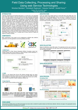
  • 1. Field Data Collecting, Processing and Sharing: Using web Service Technologies Niroshan Bandara*, Venkatesh Raghavan*, Daisuke Yoshida*, Gerald Fenoy** *Osaka City University, Japan **GeoLabs sarl, France INTRODUCTION Collecting, Distributing and Analyzing field data is a crucial part in any geospatial study. Field data collection tools and methods have been developed significantly due to the advancement of technologies such as Global Navigational Satellite Systems (GNSS) and development of smartphones. Accurate field data collection is also a necessary task for broad spatial data analysis and proper decision making. Development of Web technologies led to share the data and information effectively. This study tries to develop a framework based on the Geospatial Semantic Web technologies for disseminating and processing field data. Experimental results from an implemented prototype show that the proposed framework allows to visualize and process the field data in any context. The system of this study is capable of distributing and processing field data using web application. Moreover, the study demonstrates the importance and the capabilities of web services for spatial data gathering and processing. The system has been developed based on Free and Open Source Software (FOSS) packages such as ZOO-Project, Open Data Kit, etc. It enables user to further improve or deploy the system for variety of studies. COMPONENTS Main components of the project can be categorized as Mobile data collection applications and GIS applications concerning Desktop and Web. 1 2 3 2. QGIS QGIS is a user friendly Open Source GIS software package which can import layesr locally and online from a server as a service such as WFS, WMS. And QGIS has capabilities to manipulate various types of spatial data formats such as KML, SVG, GeoTIFF, GeoJSON, PostGIS, SpatiaLite, MSSQL, etc. 1. ZOO-Project ZOO-Project is an Open Source Geospatial (OSGeo) Foundation project that enables existing open source libraries to interact through its WPS framework. It consists with three components as describe below; ARCHITECTURE Users can exploit their mobile devices to record field data using ODK suite. The data will be sent to ODK Aggregate, which is running on an Apache Tomcat server backed with a PostgreSQL database. Then the data is published through the GeoServer. Finally data can be visualized using web viewer or it can be processed by ZOO-Project as WPS or QGIS as desktop client. WPS XLS Forms Convert Database WMS WFS ODK COLLECT Desktop GIS Web viewer Web GIS application Client side Server side AGGREGATE DATA VISUALIZATION Data Visualization; (a) View submission; (b) Web viewer (a) (b) DATA COLLECTION Data are collected by using ODK collect. The application let the user to insert the GPS location automatically. And other data such as multimedia and text/numbers can be entered manually. ODK Collect; (a) Survey forms; (b) GPS information; (c) Input Images; (d) Additional data inputs (a) (b) (c) (d) As web processing Data imports to QGIS and process ; (a) Import from PosrgreSQL database; (b) Import as WFS (c) Analyse in QGIS Web processing interface; (a) Data points; (b) Result after processing As desktop client DATA PROCESS (a) (b) (c) (a) (b) CONCLUSION Advancement of Mobile phone and Web technologies has been able to simplify the spatial analysis and field data collection. Barriers and gaps in the geospatial science can be truly addressed by developing such systems. ZOO service ZOO API ZOO Kernel • Code – C, Python, java, Perl, JavaScript • .zcfg – zoo configuration file • JS script – for WPS chaining • Classes – zoo request, zoo process, etc WPS Engine OpenLayers | UDIG | Your Client WPS Client 3. Open Data Kit ODK consists of three modules as shown below: Aggregate ODK Build is used to create and design the field survey forms. ODK Aggregate is server- side module which provides blank forms to ODK collect and work as a data repository. ODK collect is the client- side module and it is an app which can be installed on the Android mobiles. FOSS4G 2016 NARA.KANSAI