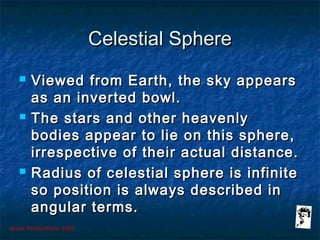
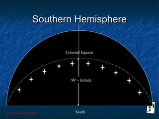
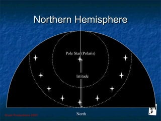
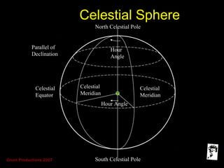
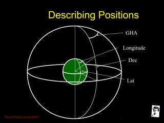
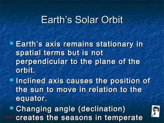
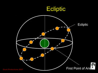
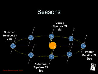
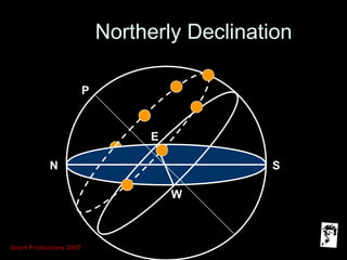
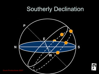
The document discusses basic principles of the celestial sphere and movement of heavenly bodies. It describes how the sky appears as an inverted bowl and celestial positions are measured in angular terms using the celestial equator and meridians. The celestial sphere rotates eastward daily, making bodies appear to move westward. Positions on Earth use latitude and longitude while the celestial sphere uses declination and hour angle. The inclined axis of Earth's orbit around the sun causes changing declinations that create the seasons in temperate regions.
Brilliant Lecture delivered to me in Alagappa Engineering college Workshop.
The Global Positioning System (GPS) is a satellite
based radio navigation system provided by the
United States Department of Defence. It gives
unequaled accuracy and flexibility in positioning
for navigation, surveying and GIS data collection.
Measuring the size and shape of the Earth using the latest Surveying techniques. Includes a discussion on reference systems, projections, datums and coordinate transformations.
When a geosynchronous satellite is placed directly above the Equator with a circular orbit and angular velocity identical to that of the Earth, the satellite is known as a geostationary satellite.
Differential Global Positioning System (DGPS) is an enhancement to Global Positioning System that provides improved location accuracy, from the
15-meter nominal GPS accuracy to about 10 cm in case of the best implementations. Differential Global Positioning System (DGPS) is a method of providing differential corrections to a Global Positioning System (GPS) receiver in order to improve the accuracy of the navigation solution. DGPS corrections originate from a reference station at a known location. The receivers in these reference stations can estimate errors in the GPS because, unlike the general population of GPS receivers, they have an accurate knowledge of their position.
DGPS uses a network of fixed, ground-based reference stations to broadcast the difference between the positions indicated by the GPS (satellite) systems and the known fixed positions. These stations broadcast the difference between the measured satellite pseudoranges and actual (internally computed) pseudoranges, and receiver stations may correct their pseudoranges by the same amount. The digital correction signal is typically broadcast locally over ground-based transmitters of shorter range.
This content introduces the Global Navigation Satellite System (GNSS), its example, earth observation orbit types, coordinate systems, GNSS time system, converting height (ellipsoidal, geoid, orthometric heights) and various GNSS applications.
This Presentation is to made concepts about measuring the earth (to locate position of any person on the whole earth). For this purpose we re going step by step basis in this presentation.These steps are mentioned as contents. After that you may able to learn about measuring a person's position of earth. Thank you!
The Sky
Astronomy is about us. As we learn about astronomy, we learn about ourselves. We search for an answer to the question “What are we?” The quick answer is that we are thinking creatures living on a planet that circles a star we call the sun. In this chapter, we begin trying to understand that answer. What does it mean to live on a planet?
The preceding chapter gave us a quick overview of the universe, and chapters later in the book will discuss the details. This chapter and the next help us understand what the universe looks like seen from the surface of our spinning planet.
But appearances are deceiving. We will see in Chapter 4 how difficult it has been for humanity to understand what we see in the #sky every day. In fact, we will discover that modern science was born when people tried to understand the appearance of the sky.
The Charming Genius of the Apollo Guidance ComputerBrian Troutwine
The Apollo Project was the first flight system to deploy with a digital, general-purpose computer made of integrated circuits at its core: the Apollo Guidance Computer (AGC). It was a complete research project: no IC computer had run consecutively for more than a few hours, sophisticated programming techniques were unknown and the interactive human/computer interface had to be invented and made to appeal to astronauts opposed to machine interference in flight operations.
In this talk I'll give the historical context for the AGC, discuss its initial design and the evolution of this design as the Apollo Project progressed. We'll do a deep-dive on the machine architecture and note how tight integration with a special-purpose vehicle admitted incredibly sophisticated behaviour from a primitive machine. We'll further discuss the human/computer interface for the AGC, how the astronaut's flight roles dictated the computer's role and vice versa. Motivating examples from select Apollo flights will be used.
Throughout, we'll keep an eye on lessons to be gleaned from the experience of engineering the AGC and how we can adapt these lessons to modern computer systems in mission-critical deployments.
Celestial bodies in the Solar System: the Sun, planets, satellites, comets, a...andare2
For primary students in grade 4 in Madrid bilingual state schools.
For more quality educational content, visit my YouTube channel:
https://www.youtube.com/channel/UCQGYTvyHHivB7GT9q04vT0A
Company Valuation webinar series - Tuesday, 4 June 2024FelixPerez547899
This session provided an update as to the latest valuation data in the UK and then delved into a discussion on the upcoming election and the impacts on valuation. We finished, as always with a Q&A
Top mailing list providers in the USA.pptxJeremyPeirce1
Discover the top mailing list providers in the USA, offering targeted lists, segmentation, and analytics to optimize your marketing campaigns and drive engagement.
Putting the SPARK into Virtual Training.pptxCynthia Clay
This 60-minute webinar, sponsored by Adobe, was delivered for the Training Mag Network. It explored the five elements of SPARK: Storytelling, Purpose, Action, Relationships, and Kudos. Knowing how to tell a well-structured story is key to building long-term memory. Stating a clear purpose that doesn't take away from the discovery learning process is critical. Ensuring that people move from theory to practical application is imperative. Creating strong social learning is the key to commitment and engagement. Validating and affirming participants' comments is the way to create a positive learning environment.
[Note: This is a partial preview. To download this presentation, visit:
https://www.oeconsulting.com.sg/training-presentations]
Sustainability has become an increasingly critical topic as the world recognizes the need to protect our planet and its resources for future generations. Sustainability means meeting our current needs without compromising the ability of future generations to meet theirs. It involves long-term planning and consideration of the consequences of our actions. The goal is to create strategies that ensure the long-term viability of People, Planet, and Profit.
Leading companies such as Nike, Toyota, and Siemens are prioritizing sustainable innovation in their business models, setting an example for others to follow. In this Sustainability training presentation, you will learn key concepts, principles, and practices of sustainability applicable across industries. This training aims to create awareness and educate employees, senior executives, consultants, and other key stakeholders, including investors, policymakers, and supply chain partners, on the importance and implementation of sustainability.
LEARNING OBJECTIVES
1. Develop a comprehensive understanding of the fundamental principles and concepts that form the foundation of sustainability within corporate environments.
2. Explore the sustainability implementation model, focusing on effective measures and reporting strategies to track and communicate sustainability efforts.
3. Identify and define best practices and critical success factors essential for achieving sustainability goals within organizations.
CONTENTS
1. Introduction and Key Concepts of Sustainability
2. Principles and Practices of Sustainability
3. Measures and Reporting in Sustainability
4. Sustainability Implementation & Best Practices
To download the complete presentation, visit: https://www.oeconsulting.com.sg/training-presentations
Implicitly or explicitly all competing businesses employ a strategy to select a mix
of marketing resources. Formulating such competitive strategies fundamentally
involves recognizing relationships between elements of the marketing mix (e.g.,
price and product quality), as well as assessing competitive and market conditions
(i.e., industry structure in the language of economics).
B2B payments are rapidly changing. Find out the 5 key questions you need to be asking yourself to be sure you are mastering B2B payments today. Learn more at www.BlueSnap.com.
Premium MEAN Stack Development Solutions for Modern BusinessesSynapseIndia
Stay ahead of the curve with our premium MEAN Stack Development Solutions. Our expert developers utilize MongoDB, Express.js, AngularJS, and Node.js to create modern and responsive web applications. Trust us for cutting-edge solutions that drive your business growth and success.
Know more: https://www.synapseindia.com/technology/mean-stack-development-company.html
Premium MEAN Stack Development Solutions for Modern Businesses
Celestial sphere lrg
1. Grunt Productions 2007
Simple AstronomicalSimple Astronomical
PrinciplesPrinciples
(Introduction - The Celestial(Introduction - The Celestial
Sphere)Sphere)
A brief by Lance GrindleyA brief by Lance Grindley
2. Grunt Productions 2007
CoveringCovering
Principles of the CelestialPrinciples of the Celestial
SphereSphere
Movement of HeavenlyMovement of Heavenly
BodiesBodies
Simple astronomicalSimple astronomical
definitionsdefinitions
Combined co-ordinateCombined co-ordinate
systemsystem
3. Grunt Productions 2007
Celestial SphereCelestial Sphere
Viewed from Earth, the sky appearsViewed from Earth, the sky appears
as an inverted bowl.as an inverted bowl.
The stars and other heavenlyThe stars and other heavenly
bodies appear to lie on this sphere,bodies appear to lie on this sphere,
irrespective of their actual distance.irrespective of their actual distance.
Radius of celestial sphere is infiniteRadius of celestial sphere is infinite
so position is always described inso position is always described in
angular terms.angular terms.
4. Grunt Productions 2007
Relative Motion of theRelative Motion of the
Celestial SphereCelestial Sphere
Earth rotates eastwards at one revolutionEarth rotates eastwards at one revolution
with respect to the sun every solar day.with respect to the sun every solar day.
Heavenly bodies appear to move westwardsHeavenly bodies appear to move westwards
rising in the east and setting in the west.rising in the east and setting in the west.
Rate of rotation and apparent movement isRate of rotation and apparent movement is
360360oo
divided by 24 hours = 15divided by 24 hours = 15oo
per hourper hour
Angular east/west movement is measured onAngular east/west movement is measured on
the equator and calledthe equator and called “hour angle”.“hour angle”.
7. Grunt Productions 2007
Celestial SphereCelestial Sphere
North Celestial Pole
South Celestial Pole
Celestial
Equator
Parallel of
Declination
Celestial
Meridian
Celestial
Meridian
Hour
Angle
Hour Angle
8. Grunt Productions 2007
Positions onPositions on
Earth/Celestial SphereEarth/Celestial Sphere
Positions are related toPositions are related to
Equator and GreenwichEquator and Greenwich
MeridianMeridian
Latitude and Longitude usedLatitude and Longitude used
on Earth’s surfaceon Earth’s surface
Declination and GreenwichDeclination and Greenwich
Hour Angle (GHA) used onHour Angle (GHA) used on
Celestial SphereCelestial Sphere
10. Grunt Productions 2007
Earth’s Solar OrbitEarth’s Solar Orbit
Earth’s axis remains stationary inEarth’s axis remains stationary in
spatial terms but is notspatial terms but is not
perpendicular to the plane of theperpendicular to the plane of the
orbit.orbit.
Inclined axis causes the position ofInclined axis causes the position of
the sun to move in relation to thethe sun to move in relation to the
equator.equator.
Changing angle (declination)Changing angle (declination)
creates the seasons in temperatecreates the seasons in temperate
15. Grunt Productions 2007
ConclusionsConclusions
Concept of Celestial Sphere allows usConcept of Celestial Sphere allows us
to use spherical trigonometry toto use spherical trigonometry to
measure relative positions and solvemeasure relative positions and solve
problems.problems.
A precise time is required to predict theA precise time is required to predict the
relative position of an astronomicalrelative position of an astronomical
body.body.
The changing declination of the sunThe changing declination of the sun
creates the seasons and changes timescreates the seasons and changes times
of rise and set.of rise and set.
Editor's Notes
Welcome
GPS could be considered one of the most successful navigation systems of all time. The system has revolutionised navigation both commercially and in warfare.
Why should we even consider astro-navigation in this new technological age?
There are some factors to consider:
a. GPS is currently surprisingly easy to jam.
b. The current fit is not without problems and there is little redundancy.
c. Professional sense of achievement.
d. Specifically required to conform to STCW.
The primary method of calculating your position using astronomical data is the use of the NAVPAC programme produced by HMNAO.
Purpose of this introduction is to enable you to understand a little more about the principles of astro-navigation and the way the programme calculates a position.
An understanding of the concept of the celestial sphere will enable you to understand the simple explanation of the sight programme and hopefully will prove to be of general interest.
The stars exist at very different distances from the earth, some a mere 5 or 6 light-years away but a number at 1000 light-years or greater distances.
The celestial sphere assumes that all stars and planets (which are of course much closer) are at a similar distance, fixed on the inside of a sphere of infinite radius. The earth of course is assumed to lie at the centre of this system.
One revolution in 24 hours is the equivalent of 15o per hour. This is referred to as “Arc to Time”.
The table for calculating the equivalent time period for comparison with longitude is contained in the NA on the first of the buff coloured pages.
Note that the time correction is always added for westerly longitudes and subtracted for easterly longitudes.
If we examine the relative movement of stars, firstly by looking south from any northerly temperate latitude, the following will be observed:
a. Stars rise in the east and set in the west.
b. The path of very star or planet is parallel to the line of the celestial equator
c. Heavenly bodies reach their maximum altitude as they pass due south (cross the observer’s meridian).
d. The maximum altitude achieved by the equator is 90o - latitude so the maximum altitude of any body is dictated by latitude and its angle north or south of the celestial equator.
Looking northwards towards the pole, the altitude of the pole (and Polaris) will be the same as the observer’s latitude.
The stars which lie below the pole, plus all the stars at similar angular distances, will be circumpolar. They are visible throughout the night.
The Plough or Big Dipper consists entirely of circumpolar stars.
Although it is not necessary to look at the celestial sphere in detail, a broad understanding of some of the terms will help our understanding of the principles of astro-navigation.
The celestial equator is a great circle which is perpendicular to the earth’s axis which joins the north and south celestial poles.
Any great circle, or semi great circle, passing through the north and south celestial poles will be a celestial meridian.
Each celestial meridian defines a plane, and the angle between any two planes, created by celestial meridians, is called an hour angle.
The hour angle can be measured at the pole or along the plane of the equator.
There is a direct correlation between position described on the surface of the earth in terms of latitude and longitude, and position within the celestial sphere, defined in terms of declination and hour angle.
Declination is the direct equivalent of latitude.
If the hour angle is measured from the Greenwich celestial meridian then it is termed the Greenwich Hour Angle (GHA).
By convention the GHA is always measured westwards, so the angle is always increasing with time when measuring the angle to any point on the celestial sphere.
If GHA is less than 180 then GHA is the direct equivalent of longitude, but if GHA is greater than 180, then it must be subtracted from 360 to give the numerical equivalent.
The relationship between positions on the earth and those on the celestial sphere is demonstrated on the above drawing.
Before leaving the celestial sphere, it is worth quickly looking at the earth’s solar orbit, and seeing why the sun’s declination changes slowly throughout the year.
The earth’s spin axis is inclined to the plane of its orbit by an angle of 23.5. This is the sun’s maximum declination, north and south, and defines the limits of the tropics.
The relationship between positions on the earth and those on the celestial sphere is demonstrated on the above drawing.
Starting at the spring equinox, the declination of the sun will be zero (the sun will appear to lie on the celestial equator).
The declination of the sun will slowly increase (northerly) until it reaches a maximum at the summer solstice.
The process then reverses and the apparent position of the sun moves back to the autumnal equinox, the winter solstice and back to the spring equinox again.
The path of the sun around the celestial sphere is called the ecliptic.
If we look at a typical period of daylight during the summer it will be seen that:
a. the sun moves more or less parallel to the equator;
b. if the declination is northerly, the sun will rise to the north of east and set to the north of west;
c. because the arc of the sun’s track is greater than 180°, the period of daylight will be more than 12 hours.