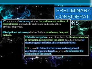
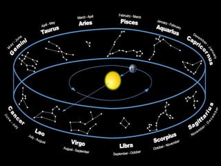
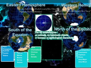
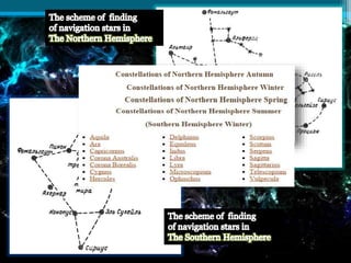
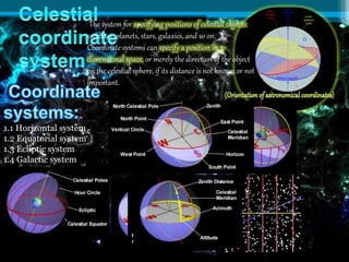
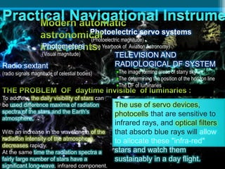
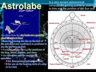
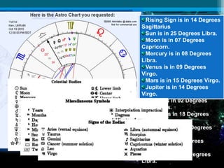
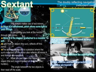
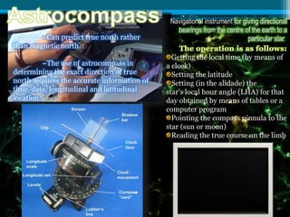
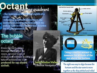
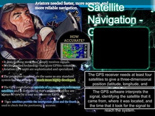
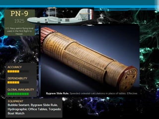
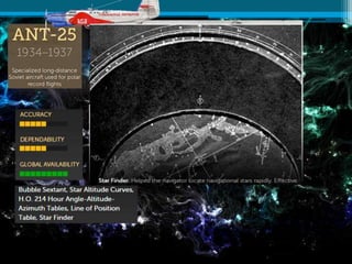
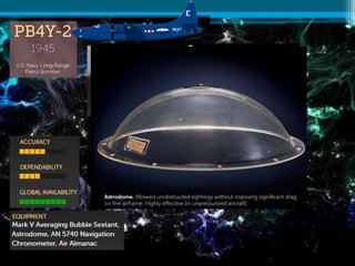
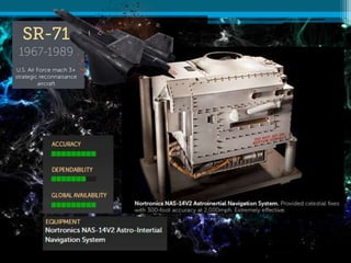
The document discusses various methods and instruments used for celestial navigation. It describes tools like the sextant, astrolabe, and octant that were used to determine position by measuring the angle between celestial objects and the horizon. It also discusses coordinate systems and modern GPS technology used for navigation.
The Sky
Astronomy is about us. As we learn about astronomy, we learn about ourselves. We search for an answer to the question “What are we?” The quick answer is that we are thinking creatures living on a planet that circles a star we call the sun. In this chapter, we begin trying to understand that answer. What does it mean to live on a planet?
The preceding chapter gave us a quick overview of the universe, and chapters later in the book will discuss the details. This chapter and the next help us understand what the universe looks like seen from the surface of our spinning planet.
But appearances are deceiving. We will see in Chapter 4 how difficult it has been for humanity to understand what we see in the #sky every day. In fact, we will discover that modern science was born when people tried to understand the appearance of the sky.
The Charming Genius of the Apollo Guidance ComputerBrian Troutwine
The Apollo Project was the first flight system to deploy with a digital, general-purpose computer made of integrated circuits at its core: the Apollo Guidance Computer (AGC). It was a complete research project: no IC computer had run consecutively for more than a few hours, sophisticated programming techniques were unknown and the interactive human/computer interface had to be invented and made to appeal to astronauts opposed to machine interference in flight operations.
In this talk I'll give the historical context for the AGC, discuss its initial design and the evolution of this design as the Apollo Project progressed. We'll do a deep-dive on the machine architecture and note how tight integration with a special-purpose vehicle admitted incredibly sophisticated behaviour from a primitive machine. We'll further discuss the human/computer interface for the AGC, how the astronaut's flight roles dictated the computer's role and vice versa. Motivating examples from select Apollo flights will be used.
Throughout, we'll keep an eye on lessons to be gleaned from the experience of engineering the AGC and how we can adapt these lessons to modern computer systems in mission-critical deployments.
Celestial bodies in the Solar System: the Sun, planets, satellites, comets, a...andare2
For primary students in grade 4 in Madrid bilingual state schools.
For more quality educational content, visit my YouTube channel:
https://www.youtube.com/channel/UCQGYTvyHHivB7GT9q04vT0A
Celestial astronomy, the study of celestial objects and phenomena beyond Earth's atmosphere, captivates the imagination and fuels our quest to understand the universe's vastness. It delves into the mysteries of stars, galaxies, planets, and other cosmic entities, unraveling the intricacies of their formation, evolution, and behavior.
At the heart of celestial astronomy lies the study of stars, those luminous beacons scattered throughout the cosmos. Astronomers examine stars of various sizes, temperatures, and ages, peering into their cores to decipher the nuclear fusion processes that sustain their brilliance. Through spectroscopy, they analyze the light emitted by stars, unveiling clues about their chemical compositions, distances, and motions.
Galaxies, sprawling collections of stars, gas, and dust, present another frontier in celestial exploration. Astronomers classify galaxies based on their shapes, from spiral and elliptical to irregular, unraveling the cosmic ballet of gravity, dark matter, and dark energy that shapes their structures and dynamics. They probe the depths of galactic cores, where supermassive black holes lurk, influencing their surroundings in profound ways.
Planets, moons, and other celestial bodies within our solar system offer windows into both the past and the future. Through telescopic observations and robotic explorers, scientists study the diverse landscapes of rocky worlds like Mars, the gaseous giants of Jupiter and Saturn, and the icy realms of the outer solar system. By analyzing meteorites and lunar samples, they piece together the solar system's turbulent history, from its violent beginnings to the emergence of life on Earth.
Celestial astronomy also encompasses the study of transient phenomena such as supernovae, black holes, and gamma-ray bursts, whose fleeting brilliance illuminates the cosmos for brief moments. By observing these cosmic cataclysms across the electromagnetic spectrum, astronomers glean insights into the most extreme environments in the universe.
In essence, celestial astronomy is a journey of exploration and discovery, spanning billions of light-years and countless eons. It inspires wonder, curiosity, and a deep appreciation for the grandeur of the cosmos, reminding us of our place in the vast tapestry of the universe.
Filed astronomy a part of surveying-II.
Astronomy usefully a new project planning and construction. These topic cover " Filed Astronomy define & common coordinate systems " according by tabular form.
In order to use this scheme- Kepler had to have a series of Martian ob.pdfsidkucheria
In order to use this scheme, Kepler had to have a series of Martian observations 687 days apart,
and here Tycho's otserving books provided a veritable gold mine. We can follos this procedure
using the same Tyehonic observations that Kepler used; these are found in the following table.
For this exercise, graph poper will be used to make it easier to liae up the peotractor. Find the
center of the araph paner (the Sgn) and draw a straight ling from the center to the risht hand rdae,
parallel to the urid lines. The end of this line represents the basic 00 directice ia space. the
direction of the Sun as seen from the Earth at the time of the vemal equinox. Heliocentric
longitude is measured from this linc. Draw a circle of 4 cantimeters radius te represent the
F.arth's orbit. (Alitough the orbits of Mars and the Earth are actually ellipses, we will see that the
circles are pretry good approximations,) Using the protractor centered on the Sun and the vereal
cquines as the startine line lav off ceunterclockwise the heliocentric longitudes of the Farth for
each date in the table, and label the date. Next with the Earth as the center and with 0 in the
direction of and along a line parallel to the vernal squinas. mark off ceuntereleckwise the
directions for the scesentric longifudes of Mars, For each pair of observations, the position of
Mars in its orbit lies at the imfersection of the lines drawn from both Earth positions through the
corresponding goocentric leagitudes of Mars. The nexi step is to determine the center of the
circle that will approximate the orbit of Mars. What is needed is the center of the circle which
can be determined by taking the perpendicular bisector of three chords of the circle. This method
will be discused in class. Dae to constraction errors, these three lines may not all incrsect in one
point, so you may have to establish the "best center". The distance from the center to one of
Mars' positions will give you the radius of the eircle. Draw the circle representine the orbit of
Mars The line from the Sun through the eenter of Mars orbit will lie on the major axis of the
oebit of Mars. Derw in the maior avis so. that it wasses threash the Smn. the center of Mars"
orbit, and intersets the erbit of Mars. lahel the perihelion and aphelion positions of Mars.
Determine the distance Mars is from the Son using the scals that one astronamical unit equals 5
ecatimeters. The eceestricity (c) of the orbit is the ratio of the distanse betwoen the Sun and the
center of the orbit for Mars and the semi-major axis of the orbic, measured int the same usits.
Determine the eccentrisity (c). PURPOSE: To deternine the orbit of Mars from a limined set of
observations. PROCEDURE: Using some of the oboervations of Mans made by Tycho and the
method developed by Kepler, an approsimute erbit for the planet Mars will be determined. From
our earthbound viewpoint, the eccentricity of Mars ocbit provides the most interesting aspest of
the planef's motion. .
About
Indigenized remote control interface card suitable for MAFI system CCR equipment. Compatible for IDM8000 CCR. Backplane mounted serial and TCP/Ethernet communication module for CCR remote access. IDM 8000 CCR remote control on serial and TCP protocol.
• Remote control: Parallel or serial interface.
• Compatible with MAFI CCR system.
• Compatible with IDM8000 CCR.
• Compatible with Backplane mount serial communication.
• Compatible with commercial and Defence aviation CCR system.
• Remote control system for accessing CCR and allied system over serial or TCP.
• Indigenized local Support/presence in India.
• Easy in configuration using DIP switches.
Technical Specifications
Indigenized remote control interface card suitable for MAFI system CCR equipment. Compatible for IDM8000 CCR. Backplane mounted serial and TCP/Ethernet communication module for CCR remote access. IDM 8000 CCR remote control on serial and TCP protocol.
Key Features
Indigenized remote control interface card suitable for MAFI system CCR equipment. Compatible for IDM8000 CCR. Backplane mounted serial and TCP/Ethernet communication module for CCR remote access. IDM 8000 CCR remote control on serial and TCP protocol.
• Remote control: Parallel or serial interface
• Compatible with MAFI CCR system
• Copatiable with IDM8000 CCR
• Compatible with Backplane mount serial communication.
• Compatible with commercial and Defence aviation CCR system.
• Remote control system for accessing CCR and allied system over serial or TCP.
• Indigenized local Support/presence in India.
Application
• Remote control: Parallel or serial interface.
• Compatible with MAFI CCR system.
• Compatible with IDM8000 CCR.
• Compatible with Backplane mount serial communication.
• Compatible with commercial and Defence aviation CCR system.
• Remote control system for accessing CCR and allied system over serial or TCP.
• Indigenized local Support/presence in India.
• Easy in configuration using DIP switches.
Saudi Arabia stands as a titan in the global energy landscape, renowned for its abundant oil and gas resources. It's the largest exporter of petroleum and holds some of the world's most significant reserves. Let's delve into the top 10 oil and gas projects shaping Saudi Arabia's energy future in 2024.
Sachpazis:Terzaghi Bearing Capacity Estimation in simple terms with Calculati...Dr.Costas Sachpazis
Terzaghi's soil bearing capacity theory, developed by Karl Terzaghi, is a fundamental principle in geotechnical engineering used to determine the bearing capacity of shallow foundations. This theory provides a method to calculate the ultimate bearing capacity of soil, which is the maximum load per unit area that the soil can support without undergoing shear failure. The Calculation HTML Code included.
Overview of the fundamental roles in Hydropower generation and the components involved in wider Electrical Engineering.
This paper presents the design and construction of hydroelectric dams from the hydrologist’s survey of the valley before construction, all aspects and involved disciplines, fluid dynamics, structural engineering, generation and mains frequency regulation to the very transmission of power through the network in the United Kingdom.
Author: Robbie Edward Sayers
Collaborators and co editors: Charlie Sims and Connor Healey.
(C) 2024 Robbie E. Sayers
Student information management system project report ii.pdfKamal Acharya
Our project explains about the student management. This project mainly explains the various actions related to student details. This project shows some ease in adding, editing and deleting the student details. It also provides a less time consuming process for viewing, adding, editing and deleting the marks of the students.
Forklift Classes Overview by Intella PartsIntella Parts
Discover the different forklift classes and their specific applications. Learn how to choose the right forklift for your needs to ensure safety, efficiency, and compliance in your operations.
For more technical information, visit our website https://intellaparts.com
Vaccine management system project report documentation..pdfKamal Acharya
The Division of Vaccine and Immunization is facing increasing difficulty monitoring vaccines and other commodities distribution once they have been distributed from the national stores. With the introduction of new vaccines, more challenges have been anticipated with this additions posing serious threat to the already over strained vaccine supply chain system in Kenya.
Quality defects in TMT Bars, Possible causes and Potential Solutions.PrashantGoswami42
Maintaining high-quality standards in the production of TMT bars is crucial for ensuring structural integrity in construction. Addressing common defects through careful monitoring, standardized processes, and advanced technology can significantly improve the quality of TMT bars. Continuous training and adherence to quality control measures will also play a pivotal role in minimizing these defects.
Water scarcity is the lack of fresh water resources to meet the standard water demand. There are two type of water scarcity. One is physical. The other is economic water scarcity.
Event Management System Vb Net Project Report.pdfKamal Acharya
In present era, the scopes of information technology growing with a very fast .We do not see any are untouched from this industry. The scope of information technology has become wider includes: Business and industry. Household Business, Communication, Education, Entertainment, Science, Medicine, Engineering, Distance Learning, Weather Forecasting. Carrier Searching and so on.
My project named “Event Management System” is software that store and maintained all events coordinated in college. It also helpful to print related reports. My project will help to record the events coordinated by faculties with their Name, Event subject, date & details in an efficient & effective ways.
In my system we have to make a system by which a user can record all events coordinated by a particular faculty. In our proposed system some more featured are added which differs it from the existing system such as security.
Immunizing Image Classifiers Against Localized Adversary Attacksgerogepatton
This paper addresses the vulnerability of deep learning models, particularly convolutional neural networks
(CNN)s, to adversarial attacks and presents a proactive training technique designed to counter them. We
introduce a novel volumization algorithm, which transforms 2D images into 3D volumetric representations.
When combined with 3D convolution and deep curriculum learning optimization (CLO), itsignificantly improves
the immunity of models against localized universal attacks by up to 40%. We evaluate our proposed approach
using contemporary CNN architectures and the modified Canadian Institute for Advanced Research (CIFAR-10
and CIFAR-100) and ImageNet Large Scale Visual Recognition Challenge (ILSVRC12) datasets, showcasing
accuracy improvements over previous techniques. The results indicate that the combination of the volumetric
input and curriculum learning holds significant promise for mitigating adversarial attacks without necessitating
adversary training.
Immunizing Image Classifiers Against Localized Adversary Attacks
Celestial navigation
1. :
the ancient art and science of
position fixing
Created by:
Student of IAN 409
Anastasiia Kovalova
Kiev-2015
2. The science of Astronomy studies the positions and motions of
celestial bodies and seeks to understand and explain their
physical properties.
Navigational astronomy deals with their coordinates, time, and
motions.
Celestial navigation - a set of methods for the determination
of navigation parameters of the object, based on the use of
electromagnetic radiation of astronomical objects.
It is used to determine the course and navigational
coordinates at ground targets, as well as to determine the
orientation of the aircraft.
7. The system for specifying positions of celestial objects:
satellites, planets, stars, galaxies, and so on.
Coordinate systems can specify a position in 3-
dimensional space, or merely the direction of the object
on the celestial sphere, if its distance is not known or not
important.
1.1 Horizontal system
1.2 Equatorial system
1.3 Ecliptic system
1.4 Galactic system
1.5 Supergalactic system
8. Photoelectric servo systems
(Photoelectric magnitude)
(The Yearbook of Aviation Astronomy)Photometers
(Visual magnitude)
To address the daily visibility of stars can
be used difference maxima of radiation
spectra of the stars and the Earth's
atmosphere.
With an increase in the wavelength of the
radiation intensity of the atmosphere
decreases rapidly.
At the same time the radiation spectra a
fairly large number of stars have a
significant long-wave, infrared component.
The use of servo devices,
photocells that are sensitive to
infrared rays, and optical filters
that absorb blue rays will allow
to allocate these "infra-red"
stars and watch them
sustainably in a day flight.
Radio sextant
(radio signals magnitude of celestial bodies)
TELEVISION AND
RADIOLOGICAL DF SYSTEM
The image forming areas of starry sky
The determining the position of the horizon line
The DF of luminaries
9. Is a very ancient astronomical
computer for solving problems relating
to time and the position of the Sun and
stars in the sky.
to show how the sky looks at a specific
place at a given time;
done by drawing the sky on the face of
the astrolabe and marking it so positions in
the sky are easy to find;
locating and predicting the positions of
the Sun, Moon, planets, and stars;
the astrolabe and the mariner's
astrolabe:
for determining latitude on land;
for use on the heaving deck of a ship
or in wind.
"star-taker"
10. Rising Sign is in 14 Degrees
Sagittarius
Sun is in 25 Degrees Libra.
Moon is in 07 Degrees
Capricorn.
Mercury is in 08 Degrees
Libra.
Venus is in 09 Degrees
Virgo.
Mars is in 15 Degrees Virgo.
Jupiter is in 14 Degrees
Virgo.
Saturn is in 02 Degrees
Sagittarius.
Uranus is in 18 Degrees
Aries.
Neptune is in 07 Degrees
Pisces.
Pluto is in 13 Degrees
Capricorn.
N. Node is in 00 Degrees
Libra.
11.
12.
13.
14.
15.
16. The doubly reflecting navigation
instrument used
to measure the angle between any two
visible objects.
The sextant makes use of two mirrors.
Mirror A is half-silvered, which allows some light to
pass through.
In navigating, you look at the horizon
through this mirror.
Mirror B in the diagram is attached to a movable
arm.
Light from an object (the sun), reflects off this
mirror.
The arm can be moved to a position where the
sun's reflection off the mirror also reflects off mirror A
and through the eyepiece.
What you see when this happens is one
object (the sun) superimposed on the other (the
horizon).
The angle between the two objects is
then read off the scale.
What makes sextant impractical for
modern air travel ?
Are sextants could be found in any
cockpits today?
Can a sextant be used while?
17. Navigational instrument for giving directional
bearings from the centre of the earth to a
particular star.~Can predict true north rather
than magnetic north.
~The use of astrocompass in
determining the exact direction of true
north requires the accurate information of
time, date, longitudinal and latitudinal
location.
Getting the local time (by means of
a clock)
Setting the latitude
Setting (in the alidade) the
star's local hour angle (LHA) for that
day obtained by means of tables or a
computer program
Pointing the compass pinnula to the
star (sun or moon)
Reading the true course on the limb
18. - the instrument's arc is one eighth of a
circle;
-reflecting quadrant derives from the
instrument using mirrors to reflect the
path of light to the observer and doubles
the angle measured;
Celestial Navigation Instuctor
The bubble
octant
From the early 1930s
through the end of the
1950s, several types of
civilian and military bubble
octant instruments were
produced for use aboard
aircraft.
Thesightwaseasyto alignbecausethe
horizonandthestarseemto move
togetherastheshippitchedandrolled
19. It does nothing more than simply receives signals.
It's the applied technology that gives GPSits versatility.
Aviation GPS units are sophisticated and specialized.
The principles involved are the same as any standard
system but the software is much more highly developed.
The GPS constellation consists of 24 non-geosynchronous
satellites and is designed so that a minimum of five are
always in view by a user anywhere on Earth.
Three satellites provide the intersection point and the fourth is
used to check that the positioning is accurate.
.
The GPS receiver needs at least four
satellites to give a three-dimensional
position (latitude, longitude, and
altitude).
The GPS software interprets the
signal, identifying the satellite that it
came from, where it was located, and
the time that it took for the signal to
reach the system.