The document discusses key concepts in field astronomy including:
1. The axis of rotation of Earth and how it intersects the Earth's surface at the North and South poles.
2. Latitude is the angular distance north or south of the equator, measured along a meridian.
3. Longitude is the angular distance east or west of the prime meridian, measured along the equator.
4. The celestial sphere is an imaginary sphere where astronomical objects appear to be projected for analysis of their positions. Key points on the celestial sphere like the celestial poles and equator are discussed in relation to their Earth-based counterparts.
in this section the study of the various classification of the surveying. which based the surveying is classified and how many types of the surveying? all this is presented in this slide.
and that slide how it work?
The Global Positioning System is a satellite-based radio navigation system for determination of precise position and time, using radio signals from the satellites, in real-time or in post-processing mode.
Surveying is an important part of Civil engineering. Various part like theodolite, plane table surveying, computation of area and volume are useful for all university examination and other competitive examination
Introduction, electromagnetic spectrum, electromagnetic distance measurement, types of EDM instruments, electronic digital theodolites, total station, digital levels, scanners for topographical survey, global positioning system.
Hybrid optimization of pumped hydro system and solar- Engr. Abdul-Azeez.pdffxintegritypublishin
Advancements in technology unveil a myriad of electrical and electronic breakthroughs geared towards efficiently harnessing limited resources to meet human energy demands. The optimization of hybrid solar PV panels and pumped hydro energy supply systems plays a pivotal role in utilizing natural resources effectively. This initiative not only benefits humanity but also fosters environmental sustainability. The study investigated the design optimization of these hybrid systems, focusing on understanding solar radiation patterns, identifying geographical influences on solar radiation, formulating a mathematical model for system optimization, and determining the optimal configuration of PV panels and pumped hydro storage. Through a comparative analysis approach and eight weeks of data collection, the study addressed key research questions related to solar radiation patterns and optimal system design. The findings highlighted regions with heightened solar radiation levels, showcasing substantial potential for power generation and emphasizing the system's efficiency. Optimizing system design significantly boosted power generation, promoted renewable energy utilization, and enhanced energy storage capacity. The study underscored the benefits of optimizing hybrid solar PV panels and pumped hydro energy supply systems for sustainable energy usage. Optimizing the design of solar PV panels and pumped hydro energy supply systems as examined across diverse climatic conditions in a developing country, not only enhances power generation but also improves the integration of renewable energy sources and boosts energy storage capacities, particularly beneficial for less economically prosperous regions. Additionally, the study provides valuable insights for advancing energy research in economically viable areas. Recommendations included conducting site-specific assessments, utilizing advanced modeling tools, implementing regular maintenance protocols, and enhancing communication among system components.
Automobile Management System Project Report.pdfKamal Acharya
The proposed project is developed to manage the automobile in the automobile dealer company. The main module in this project is login, automobile management, customer management, sales, complaints and reports. The first module is the login. The automobile showroom owner should login to the project for usage. The username and password are verified and if it is correct, next form opens. If the username and password are not correct, it shows the error message.
When a customer search for a automobile, if the automobile is available, they will be taken to a page that shows the details of the automobile including automobile name, automobile ID, quantity, price etc. “Automobile Management System” is useful for maintaining automobiles, customers effectively and hence helps for establishing good relation between customer and automobile organization. It contains various customized modules for effectively maintaining automobiles and stock information accurately and safely.
When the automobile is sold to the customer, stock will be reduced automatically. When a new purchase is made, stock will be increased automatically. While selecting automobiles for sale, the proposed software will automatically check for total number of available stock of that particular item, if the total stock of that particular item is less than 5, software will notify the user to purchase the particular item.
Also when the user tries to sale items which are not in stock, the system will prompt the user that the stock is not enough. Customers of this system can search for a automobile; can purchase a automobile easily by selecting fast. On the other hand the stock of automobiles can be maintained perfectly by the automobile shop manager overcoming the drawbacks of existing system.
Event Management System Vb Net Project Report.pdfKamal Acharya
In present era, the scopes of information technology growing with a very fast .We do not see any are untouched from this industry. The scope of information technology has become wider includes: Business and industry. Household Business, Communication, Education, Entertainment, Science, Medicine, Engineering, Distance Learning, Weather Forecasting. Carrier Searching and so on.
My project named “Event Management System” is software that store and maintained all events coordinated in college. It also helpful to print related reports. My project will help to record the events coordinated by faculties with their Name, Event subject, date & details in an efficient & effective ways.
In my system we have to make a system by which a user can record all events coordinated by a particular faculty. In our proposed system some more featured are added which differs it from the existing system such as security.
Sachpazis:Terzaghi Bearing Capacity Estimation in simple terms with Calculati...Dr.Costas Sachpazis
Terzaghi's soil bearing capacity theory, developed by Karl Terzaghi, is a fundamental principle in geotechnical engineering used to determine the bearing capacity of shallow foundations. This theory provides a method to calculate the ultimate bearing capacity of soil, which is the maximum load per unit area that the soil can support without undergoing shear failure. The Calculation HTML Code included.
COLLEGE BUS MANAGEMENT SYSTEM PROJECT REPORT.pdfKamal Acharya
The College Bus Management system is completely developed by Visual Basic .NET Version. The application is connect with most secured database language MS SQL Server. The application is develop by using best combination of front-end and back-end languages. The application is totally design like flat user interface. This flat user interface is more attractive user interface in 2017. The application is gives more important to the system functionality. The application is to manage the student’s details, driver’s details, bus details, bus route details, bus fees details and more. The application has only one unit for admin. The admin can manage the entire application. The admin can login into the application by using username and password of the admin. The application is develop for big and small colleges. It is more user friendly for non-computer person. Even they can easily learn how to manage the application within hours. The application is more secure by the admin. The system will give an effective output for the VB.Net and SQL Server given as input to the system. The compiled java program given as input to the system, after scanning the program will generate different reports. The application generates the report for users. The admin can view and download the report of the data. The application deliver the excel format reports. Because, excel formatted reports is very easy to understand the income and expense of the college bus. This application is mainly develop for windows operating system users. In 2017, 73% of people enterprises are using windows operating system. So the application will easily install for all the windows operating system users. The application-developed size is very low. The application consumes very low space in disk. Therefore, the user can allocate very minimum local disk space for this application.
About
Indigenized remote control interface card suitable for MAFI system CCR equipment. Compatible for IDM8000 CCR. Backplane mounted serial and TCP/Ethernet communication module for CCR remote access. IDM 8000 CCR remote control on serial and TCP protocol.
• Remote control: Parallel or serial interface.
• Compatible with MAFI CCR system.
• Compatible with IDM8000 CCR.
• Compatible with Backplane mount serial communication.
• Compatible with commercial and Defence aviation CCR system.
• Remote control system for accessing CCR and allied system over serial or TCP.
• Indigenized local Support/presence in India.
• Easy in configuration using DIP switches.
Technical Specifications
Indigenized remote control interface card suitable for MAFI system CCR equipment. Compatible for IDM8000 CCR. Backplane mounted serial and TCP/Ethernet communication module for CCR remote access. IDM 8000 CCR remote control on serial and TCP protocol.
Key Features
Indigenized remote control interface card suitable for MAFI system CCR equipment. Compatible for IDM8000 CCR. Backplane mounted serial and TCP/Ethernet communication module for CCR remote access. IDM 8000 CCR remote control on serial and TCP protocol.
• Remote control: Parallel or serial interface
• Compatible with MAFI CCR system
• Copatiable with IDM8000 CCR
• Compatible with Backplane mount serial communication.
• Compatible with commercial and Defence aviation CCR system.
• Remote control system for accessing CCR and allied system over serial or TCP.
• Indigenized local Support/presence in India.
Application
• Remote control: Parallel or serial interface.
• Compatible with MAFI CCR system.
• Compatible with IDM8000 CCR.
• Compatible with Backplane mount serial communication.
• Compatible with commercial and Defence aviation CCR system.
• Remote control system for accessing CCR and allied system over serial or TCP.
• Indigenized local Support/presence in India.
• Easy in configuration using DIP switches.
Welcome to WIPAC Monthly the magazine brought to you by the LinkedIn Group Water Industry Process Automation & Control.
In this month's edition, along with this month's industry news to celebrate the 13 years since the group was created we have articles including
A case study of the used of Advanced Process Control at the Wastewater Treatment works at Lleida in Spain
A look back on an article on smart wastewater networks in order to see how the industry has measured up in the interim around the adoption of Digital Transformation in the Water Industry.
Overview of the fundamental roles in Hydropower generation and the components involved in wider Electrical Engineering.
This paper presents the design and construction of hydroelectric dams from the hydrologist’s survey of the valley before construction, all aspects and involved disciplines, fluid dynamics, structural engineering, generation and mains frequency regulation to the very transmission of power through the network in the United Kingdom.
Author: Robbie Edward Sayers
Collaborators and co editors: Charlie Sims and Connor Healey.
(C) 2024 Robbie E. Sayers
Cosmetic shop management system project report.pdfKamal Acharya
Buying new cosmetic products is difficult. It can even be scary for those who have sensitive skin and are prone to skin trouble. The information needed to alleviate this problem is on the back of each product, but it's thought to interpret those ingredient lists unless you have a background in chemistry.
Instead of buying and hoping for the best, we can use data science to help us predict which products may be good fits for us. It includes various function programs to do the above mentioned tasks.
Data file handling has been effectively used in the program.
The automated cosmetic shop management system should deal with the automation of general workflow and administration process of the shop. The main processes of the system focus on customer's request where the system is able to search the most appropriate products and deliver it to the customers. It should help the employees to quickly identify the list of cosmetic product that have reached the minimum quantity and also keep a track of expired date for each cosmetic product. It should help the employees to find the rack number in which the product is placed.It is also Faster and more efficient way.
Student information management system project report ii.pdfKamal Acharya
Our project explains about the student management. This project mainly explains the various actions related to student details. This project shows some ease in adding, editing and deleting the student details. It also provides a less time consuming process for viewing, adding, editing and deleting the marks of the students.
Final project report on grocery store management system..pdfKamal Acharya
In today’s fast-changing business environment, it’s extremely important to be able to respond to client needs in the most effective and timely manner. If your customers wish to see your business online and have instant access to your products or services.
Online Grocery Store is an e-commerce website, which retails various grocery products. This project allows viewing various products available enables registered users to purchase desired products instantly using Paytm, UPI payment processor (Instant Pay) and also can place order by using Cash on Delivery (Pay Later) option. This project provides an easy access to Administrators and Managers to view orders placed using Pay Later and Instant Pay options.
In order to develop an e-commerce website, a number of Technologies must be studied and understood. These include multi-tiered architecture, server and client-side scripting techniques, implementation technologies, programming language (such as PHP, HTML, CSS, JavaScript) and MySQL relational databases. This is a project with the objective to develop a basic website where a consumer is provided with a shopping cart website and also to know about the technologies used to develop such a website.
This document will discuss each of the underlying technologies to create and implement an e- commerce website.
Forklift Classes Overview by Intella PartsIntella Parts
Discover the different forklift classes and their specific applications. Learn how to choose the right forklift for your needs to ensure safety, efficiency, and compliance in your operations.
For more technical information, visit our website https://intellaparts.com
1. 1
FIELD ASTRONMY
EARTH
AXIS OF ROTATION
The Axis about which earth rotates is called axis of rotation.This axis intersects earth surface
at two points, known as south pole and north pole or another way we can say that the axis
of rotation of earth is joining the passing from north pole south pole of earth.
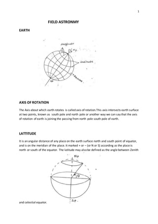
LATTITUDE
It is an angular distance of any place on the earth surface north and south point of equator,
and is on the meridian of the place. It marked + or – (or N or S) according as the place is
north or south of the equator. The latitude may also be defined as the angle between Zenith
and celestial equator.
2. 2
LONGITUDE (Ø)
The longitude of a place is the angle between fixed refrence meridian called the prime
meridian or the fixed meridian and the meridian of the place .The prime meridian
universally adopted is that of Greenwich .the longitude of any place varies between 0 to 180
degree, and is reckoned as ( Ø ) degree east or west of Greenwich.
CELESTIAL SPHERE
The imaginary sphere on which all stars moon , sun , planets etc are considered to be
projected for analysis of position know as celestial sphere.
The millions of stars that we see on the sky on the cloudless night are all at varying distance
from us .Since we concerned with the relative distance rather than their actual distance
from the observer , it is exceedingly convenient to the picture the stars are distributed on
the surface on The imaginary spherical sphere having its centre at the position of the
observer. The imaginary sphere on which stars appears to lie or to be studded is known as
celestial sphere. The radius of the celestial sphere may be of any value from a few thousand
meters to few thousand kilometers . Since the stars are very distance from us, the cenre of
the earth may be taken as the center of the celestial sphere.
CELESTIAL POLE
The Axis of rotation of Earth intersects celestial sphere at two points called pole points of
the celestial sphere , or we can also say that if we increase the line joining in both direction
then it intersects at the the celestial sphere at the two points ,these points are Celestial
poles
CELESTIAL EQUATER
The great circle perpendicular to axis of rotation on Celestial sphere is known as Celestial
Equator in which it is intersected by the plane of terrestrial equator. It is an special case of a
great circle in which great circle makes complete 90 degree angle with the axis of rotation of
Earth having radius equals to the radius of Celestial sphere of the system.
3. 3
GREATCIRCLE
Any circle of celestial sphere, which has center same as celestial center is known as
great circle.
The radius of the great circle is always same as the radius Celestial sphere. In any
celestial sphere there may of of infinite number of great circles.
Celestial sphere is also a type of great circle or we can also say that Celestial sphere is
the subset of set of Great circles.
ZENITH
The Point on celestial sphere vertically above observer’s position on Earth is called
Zenith point.
It may be also can understand as if the line joining the observer position on the Earth
and the the centre of earth cuts the celestial sphere then the upper position of the
observer’s position on the Celestial sphere is Zenith point
4. 4
NADIR
The Point vertically below the observers position on earth and Celestial sphere known as
Nadir point.
It may be also can understand as if the line joining the observer position on the Earth
and the the centre of earth cuts the celestial sphere then the lower position of the
observer’s position on the Celestial sphere is known as Nadir point.
VERTICLE CIRCLE
All those great circles perpendicular to passing through Zenith and Nadir called verticle
circle. They all cut the Celestial horizon at the right angle.
There can be infinity number of Great circles are possible which are passing through Zenith
and Nadir point that means there are infinite number of vertical circle are possible in the
any Celestial system.
5. 5
OBSERVERS MERIDIAN
The Verticle circle passing through pole points along Zenith and Nadir called Observer
meridian. The meridian of any particular point is that circle which passing through zenith
and Nadir of the point as well as through the poles.
Thus Observer meridian is the subset of set of verticle circle having special case when it
passing also through the poles points of celestial sphere.
PRIMEVERTICLE
The Great circle(verticle circle) perpendicular to Observers meridian called prime verticle.
Prime verticle is the subset of the set of verticle circle where the possibility of having prime
verticle in verticle circle is one with respect to number of verticle circles on celestial
sphere.It is also an special case of verticle circle.
6. 6
CELESTIAL HORIZON
The great circle which is perpendicular to zenith and nadir line called celestial horizon. It is
also called as True or rational or Geocentric horizon. It is great circle traced upon the
celestial sphere by that plane which is perpendicular to the Zenith-Nadir line ,and which
passes through the center of the Earth (Great circle is a section of a sphere when the plan
passess through the center of the sphere).
SENSIBLEHORIZON
A circle on celestial sphere parallel to celestial horizon with observer as center is known as
sensible horizon.
It is a circle in which a plane passing through the point of observations and tangential to the
earth surface ( or perpendicular to the Zenith-Nadir Line) intersects with Celestial sphere .
the line of sight of an accurately levelled telescope lies in the plane.
NOTE- The distance between celestial horizon and sensible horizon is always equals to the
radius of the earth.
7. 7
ECLIPTIC
The path traverse by Sun on celestial sphere is known as Ecliptic. It as also can be defined as
the great circle of the heavens which the sun appears to describe on the celestial sphere
with the earth as a center in a course of a year . The plane of the Ecliptic is inclined to the
plane of the Equator at an angle( angle of obliquity) of about 23 degree and 27 minutes , but
is subjected to an diminution of about 5 second in a century.
DIRECTION
HORIZONSYSTEM -
The Intersection of the observer meridian to celestial horizon will give N-S point of the
Horizon system. The Intersection of the prime verticle with Celestial horizon will give E-W
point point of the Horizon system.
EQUITERIAL SYSTEM:-
The Intersection of observer meridian with equator give North-South point of the Equitorial
System and the intersection of prime verticle with Equator gives East-West point.
9. 9
ASTRONOMICAL CO-ORDINATESYSTEM:-
HORIZONSYSTEM:-
ALTITUDE (α):-
The Angle of star measured above or below horizon towards zenith is called altitude
angle. It can also be defined as the altitude angle of celestial or heavily body is its
angular distance above the horizon , measured on the verticle circle passing through the
body.
CO-ALTITUDE(90-α):-
Angle between the observer meridian and great circle passing from the zenith and star
or projection of star is called Azimuth (A).It is also called as Zenith distance.
Note:- At the sunset and the sunrise position, altitude of sun is zero degree (α = 0).
10. 10
EQUTORIAL SYSTEM:-
DECLINATION ANGLE(δ):-
The Angle above and below equator measured along declination circle towards pole is
called the declination angle .It can also be defined as the angular distance from the plane of
Equator, measured along the star’s meridian generally called the declination circle.
It varies between 0 to 90 degree.
CO-DECLINATION ANGLE(90-δ):-
The Angle between the pole and star along the declination circle called co-declinatio also
known as a polar distance.
It can also be define as the angular distance between the heavily body from the nearer pole.
11. 11
HOUR ANGLE(H)
The Angle measured along the equator starting from the South point towards the star
position is called the Hour angle.
It may also be define as the angle between the observer’s meridian and the declination
circle passing through the body. Hour angle always measured westwards.
SPHERICAL TRIANGLE:-
Spherical triangle is that triangle which is formed upon the surface of the sphere of the
sphere by intersections of the three arcs of three Great circles and the angle formed by the
arcs at the vertices of the triangle, is called spherical triangle.
12. 12
SIDES (a,b,c):-
The Angle made at centre of sphere by any two edge is called side of spherical triangle. The
sides of spherical triangle are propotional to the angle substend by them at the centre of
the sphere .
ANGLES (A, B, C):-
The Angle between any two faces is called spherical angle.
NAPIER’S RULE
This rule is valid for the right angle spherical triangle only.
Steps:-
1) Write all parameters in sequence (Either clock wise or anti clock wise)
[ a C b A c ]
Note-Do not consider the angle which is 90 degree.
2) Keep extreme values as it is and write co-value of all other parameters.
13. 13
a C b A C
a (90-C) (90-b) (90-A) C
3) Draw Napier’s circle
4) Now we can write to formula using to given key relations
Example:-
Sin (a) = cos (90-a) x cos (90 –b) = [sin A sin b]
Sin (a) = tan (90-C) x tan c = [cot C tan c]
16. 16
Relations:-
Cos H = Sinα/(Cos θ Cosδ) – Tan θ Tan δ
Cos A = Sin δ/ (Cos θ cosα) - tan θ tan α
Star at transit position:-
(a) upper transit position (M1)
- When a star is crossing observers meridian near zenith it is known as upper transit
position.
b) Lower transit position (M2)
- When a star is crossing observers meridian opposite to zenith known as lower transit
position.
CIRUM POLAR STAR:-
Any star moving around axis of rotation of celestial which never in intersect horizon called
circum polar star.It may also be say as those star which are always above the Horizon ,and
which don’t ,therefore, set. Such a star appear to the observer to describe the circle above
the pole.
18. 18
The distance between two points along the the Earth surface may be considered as the
Great circle distance or the distance between two points on the surface of earth measured
along the sphere , On the sphere there are no straight lines these replaced by the Geodesics
on the sphere. Geodesics are the circles on the sphere of which having center coincide with
center of sphere.
Cos AB = cos a cos b + sin a sin b cos P
Arc distance (AB) = (2πR/360) x (AB )
Direction:-
Tan ((A+B)/2) = [cos ((a-b)/2)] / [cos ((a+b)/2)] x cot (p/2)
Tan ((A-B)/2) = [sin ((a-b)/2)] / [sin ((a+b)/2)] x cot (p/2)
TIME CONCEPT:-
a) TIME:-
- The Change in hour angle of star with respect to standard meridian (fixed meridian)
is called time .
b) SOLAR TIME:-
- Solar time is the calculation of passage of time based on the position of the sun in
sky. The fundamental unit of time is Day.
- There are two types of solar time
1) Mean solar time
2) Apparent solar time
c) APPARENTSOLAR TIME:-
- Time with respect to actual suns movement on celestial sphere is known as apparent
solar time (along ecliptic).
d) Meansolar time.
- According to actual suns movement, perpendicular day ≠ 24 hours exactly. There is a
we consider a fictitious moving along equator with constant rate. According to which
360 degree = 24 hours
19. 19
- A time corresponding to this fictitious sun known as a mean solar time.
e) Equation of time:-
- Difference of apparent and mean solar time is known equation of time.
f) Standard time:-
-In one century, everyone has to follow one time corresponding to the standard
meridian
Example:-
In India we considered a time of standard meridian (passes through Allahabad(82◦ 30’ E)).
g) Local mean time (LMT)
-Local mean time is aform of solar time that correct the variation of local apparent time ,
forming a uniform Time scale at a specified Longitude.
LMT = Standard time ± difference of longitude.
(+) –when place is in east of standard meridian.
(-) – When place is in west of standard meridian.
Conversion
360 degree = 24 hours
Angle Hours/Time
1◦ 1/15 Hrs.
1” 1/15 sec.
1’ 1/15 min.