Download to read offline
![IOSR Journal of Computer Engineering (IOSRJCE)
ISSN: 2278-0661 Volume 4, Issue 6 (Sep.-Oct. 2012), PP 01-05
www.iosrjournals.org
www.iosrjournals.org 1 | P a g e
SD-miner System to Retrieve Probabilistic Neighborhood Points
in Spatial Data Mining
Asst. Prof. S. G. Kulkarni1
, Asst. Prof. Padma D2
, Mr. Manjunath R. H3
1,2,3
Department of Computer Science, Gogte Institute of Technology, Belgaum.
Abstract: In GIS or Geographic Information system technology, a vast volume of spatial data has been
accumulated, thereby incurring the necessity of spatial data mining techniques. Displaying and visualizing such
data items are important aspects. But no RDBMS software is loaded with displaying the spatial result over a
MAP overlay or answer spatial queries like “all the points within” certain Neighborhood.
In this project, we propose a new spatial data mining system named SD-Miner. SD-Miner consists of
three parts: A Graphical User Interface for inputs and outputs, a Data Mining Module that processes spatial
data mining functionalities, a Data Storage Model that stores and manages spatial as well as non-spatial data
by using a DBMS. In particular, the data mining module provides major spatial data mining functionalities such
as spatial clustering, spatial classification, spatial characterization, and spatio-temporal association rule
mining. SD-Miner has its own characteristics:
(1) It supports users to perform non-spatial data mining functionalities as well as spatial data mining
functionalities intuitively and effectively.
(2) It provides users with spatial data mining functions as a form of libraries, thereby making applications
conveniently use those functions.
(3) It inputs parameters for mining as a form of database tables to increase flexibility. Result shows that
significantly reduced and precise data items are displayed through the result of this technique.
I. Introduction
Due to the development of information technology, a vast volume of data is accumulated on many
fields. Since automated methods for filtering/analyzing the data and also explaining the results are required, a
variety of data mining techniques finding new knowledge by discovering hidden rules from vast amount of data
are developed. In the field of geography, due to the development of technology for remote sensing, monitoring,
geographical information systems, and global positioning systems, a vast volume of spatial data is accumulated.
Also, there have been many studies of discovering meaningful knowledge from the spatial data. Since the spatial
data has its own characteristics different from the non-spatial data, direct using of general data mining
techniques incurs many difficulties. So there have been many studies of spatial data mining techniques
considering the characteristics of the spatial data. However, commercial tools for spatial data mining have not
been provided. Currently, many commercial data mining tools are available, but these tools not support the
spatial data mining functionalities. Also, while some academic spatial data mining tools such as Geo-Miner are
available, there are almost no commercial spatial data mining tools. So, for easy using of spatial data mining for
real spatial data applications, developments of spatial data mining tools are needed. In this paper, author
proposes a new spatial data mining system named SD-Miner. SD-Miner supports four important spatial data
mining functionalities: spatial clustering, spatial classification, spatial characterization, and spatio-temporal
association rule mining. We first analyze characteristics of previous spatial data mining techniques and suggest
techniques to improve their efficiency in developing SD-Miner [1].
II. Motivation
Spatial data mining that is, discovery of interesting, implicit knowledge in spatial databases is a highly
demanding field because very large amount of spatial data have been collected in various applications, ranging
from remote sensing, to Geographical Information Systems (GIS), computer cartography, environmental
assessment and planning etc. Spatial data has its own characteristic different from non spatial data. Direct use of
general data mining techniques incur many difficulties, so we need a spatial data mining tool for easy using of
spatial data, for spatial data application, which can be easily done by SD-miner. The SD-miner supports four
important spatial data mining functionalities as spatial clustering, spatial classification, spatial characterization
and spatial temporal association rule mining [1].](https://image.slidesharecdn.com/a0460105-131001012457-phpapp02/85/SD-miner-System-to-Retrieve-Probabilistic-Neighborhood-Points-in-Spatial-Data-Mining-1-320.jpg)
![IOSR Journal of Computer Engineering (IOSRJCE)
ISSN: 2278-0661 Volume 4, Issue 6 (Sep.-Oct. 2012), PP 01-05
www.iosrjournals.org
www.iosrjournals.org 1 | P a g e
SD-miner System to Retrieve Probabilistic Neighborhood Points
in Spatial Data Mining
Asst. Prof. S. G. Kulkarni1
, Asst. Prof. Padma D2
, Mr. Manjunath R. H3
1,2,3
Department of Computer Science, Gogte Institute of Technology, Belgaum.
Abstract: In GIS or Geographic Information system technology, a vast volume of spatial data has been
accumulated, thereby incurring the necessity of spatial data mining techniques. Displaying and visualizing such
data items are important aspects. But no RDBMS software is loaded with displaying the spatial result over a
MAP overlay or answer spatial queries like “all the points within” certain Neighborhood.
In this project, we propose a new spatial data mining system named SD-Miner. SD-Miner consists of
three parts: A Graphical User Interface for inputs and outputs, a Data Mining Module that processes spatial
data mining functionalities, a Data Storage Model that stores and manages spatial as well as non-spatial data
by using a DBMS. In particular, the data mining module provides major spatial data mining functionalities such
as spatial clustering, spatial classification, spatial characterization, and spatio-temporal association rule
mining. SD-Miner has its own characteristics:
(1) It supports users to perform non-spatial data mining functionalities as well as spatial data mining
functionalities intuitively and effectively.
(2) It provides users with spatial data mining functions as a form of libraries, thereby making applications
conveniently use those functions.
(3) It inputs parameters for mining as a form of database tables to increase flexibility. Result shows that
significantly reduced and precise data items are displayed through the result of this technique.
I. Introduction
Due to the development of information technology, a vast volume of data is accumulated on many
fields. Since automated methods for filtering/analyzing the data and also explaining the results are required, a
variety of data mining techniques finding new knowledge by discovering hidden rules from vast amount of data
are developed. In the field of geography, due to the development of technology for remote sensing, monitoring,
geographical information systems, and global positioning systems, a vast volume of spatial data is accumulated.
Also, there have been many studies of discovering meaningful knowledge from the spatial data. Since the spatial
data has its own characteristics different from the non-spatial data, direct using of general data mining
techniques incurs many difficulties. So there have been many studies of spatial data mining techniques
considering the characteristics of the spatial data. However, commercial tools for spatial data mining have not
been provided. Currently, many commercial data mining tools are available, but these tools not support the
spatial data mining functionalities. Also, while some academic spatial data mining tools such as Geo-Miner are
available, there are almost no commercial spatial data mining tools. So, for easy using of spatial data mining for
real spatial data applications, developments of spatial data mining tools are needed. In this paper, author
proposes a new spatial data mining system named SD-Miner. SD-Miner supports four important spatial data
mining functionalities: spatial clustering, spatial classification, spatial characterization, and spatio-temporal
association rule mining. We first analyze characteristics of previous spatial data mining techniques and suggest
techniques to improve their efficiency in developing SD-Miner [1].
II. Motivation
Spatial data mining that is, discovery of interesting, implicit knowledge in spatial databases is a highly
demanding field because very large amount of spatial data have been collected in various applications, ranging
from remote sensing, to Geographical Information Systems (GIS), computer cartography, environmental
assessment and planning etc. Spatial data has its own characteristic different from non spatial data. Direct use of
general data mining techniques incur many difficulties, so we need a spatial data mining tool for easy using of
spatial data, for spatial data application, which can be easily done by SD-miner. The SD-miner supports four
important spatial data mining functionalities as spatial clustering, spatial classification, spatial characterization
and spatial temporal association rule mining [1].](https://image.slidesharecdn.com/a0460105-131001012457-phpapp02/75/SD-miner-System-to-Retrieve-Probabilistic-Neighborhood-Points-in-Spatial-Data-Mining-1-2048.jpg)
![SD-miner System to Retrieve Probabilistic Neighborhood Points in Spatial Data Mining
www.iosrjournals.org 2 | P a g e
III. Proposed Approach
This work attempts to develop a spatial data mining system, the SD-miner which consists of three
parts: A graphical user interface for inputs and outputs, a data mining module that processes spatial data mining
functionalities, a data storage model that stores and manages spatial as well as non spatial data by using a
DBMS.
Fig 1: Architecture of SD-Miner
SD-Miner is composed of three main parts (Figure 1): Graphical User Interface (GUI), SD-Miner
Module, and Data Storage Module (also, called DBMS management module) [1].
Graphical User Interface
A GUI is a type of computer human interface on a computer. It solves the blank screen problem that
confronted early computer users. These early users sat down in front of a computer and faced a blank screen,
with only a prompt. The computer gave the user no indication what the user was to do next. GUI is an attempt to
solve this blank screen problem.
Graphical user interface (GUI), a computer program that enables a person to communicate with a
computer through the use of symbols, visual metaphors, and pointing devices. Best known for its
implementation in Apple Inc.’s Macintosh and Microsoft Corporation’s Windows operating system, the GUI has
replaced the arcane and difficult textual interfaces of earlier computing with a relatively intuitive system that has
made computer operation not only easier to learn but more pleasant and natural. The GUI is now the standard
computer interface, and its components have themselves become unmistakable cultural artifacts.
Snap1- GUI
At a conceptual level, a computer human interface is a means by which “people and computers
communicate with each other". In computer science terms, the GUI is a visual operating display that the monitor
presents on the monitor to the computer operator. More specifically, a GUI is a specification for the look and
feel of the computer system. GUI usually have common characteristic such as windows, icons, menus, and
push-buttons (WIMP). Collectively, WIMP (Windows, Icons, Mouse, Pointer) are pictures that bring forth a
certain action or an action space. The user issues commands via the GUI to computer applications. GUI usually
has three major components. These three components are: a windowing system, an imaging model, and an
application program interface (API). The windowing system builds the windows, menus, and dialog boxes that
appear on the screen. The imaging model defines the fonts and graphics that appear on the screen. WIMP is
products of both the windowing system and imaging model. Finally, the API is the means in which the user
specifies how and what windows and graphics appear on the screen.](https://image.slidesharecdn.com/a0460105-131001012457-phpapp02/85/SD-miner-System-to-Retrieve-Probabilistic-Neighborhood-Points-in-Spatial-Data-Mining-2-320.jpg)
![SD-miner System to Retrieve Probabilistic Neighborhood Points in Spatial Data Mining
www.iosrjournals.org 3 | P a g e
The GUI contains some of the buttons and combo boxes which performs actions like:
1.Fetch tables- Which fetches the tables from the database.
2.View column-Which displays columns according to the query written.
3.Simple select query-which specifies the condition in term of query.
4.Select spatial co-ordinates- this button helps us to select the required longuted and latitude.
5.Select dimensions.
SD-miner Module
The SD-Miner module processes respective data mining functions and transfers the results to the data
storage module. This module provides four data mining functions as shown in fig-1.
Four important characteristics of SD-miner system:
Spatial Clustering
Spatial clustering classifies spatial objects as multiple groups according to its positional or
geographical characteristics. This proposed work uses K means clustering.
K-means is one of the simplest unsupervised learning algorithms that solve the well known clustering problem.
The procedure follows a simple and easy way to classify a given data set through a certain number of clusters
(assume k clusters). The main idea is to define k centroids, one for each cluster [2].
Spatial Classification
Usually, in the spatial classification, the objects are classified with considering of spatial and non-
spatial attributes. The spatial classification also uses the decision tree. A big difference between the spatial
classification and the classification is that the aggregation value of the spatial objects in a near region is used in
the spatial classification.
For making of a decision tree, the technique additionally uses predicates on relationship among spatial
objects as decision criteria. For this, as the first step, the spatial attributes are represented as spatial predicates
and then the possible useful predicates are extracted. For the second step, the decision tree is constructed with
the predicates. The benefits of this technique are as follows. Since the decision tree is constructed after
discarding ineffective predicates, the tree construction cost is greatly reduced. Speedy and correct classification
can be made [3].
Spatial Characterization
Spatial characterization extracts a global outline of data classes for a given spatial region by using the
spatial objects of the region. It gives simple and clear abstract information of the region. Spatial characterization
evaluates whether the characteristics of given spatial objects are expanded to near region. To do this, the objects
are defined as a neighbor of each other with considering of their distance or direction
The neighbor information is managed by using the neighbor table. The region handled by spatial
characterization can be expanded with a spatial expansion algorithm using the neighbor table [4].
Spatio-Temporal Association Rule Mining
By using spatial association rule mining, proposed system can represent topological relationship and
distance relationship of spatial objects via analyzing the relationship among spatial data and between spatial and
non-spatial data. Also, by adding of temporal data analysis, proposed system can use spatio-temporal association
rule mining.SD-Miner uses spatio-temporal association rule mining. In order to use spatial association rule
mining, the spatial relationships between spatial objects must be defined. The relationships are represented as
spatial predicates. The predicates defined by a user are stored as concept hierarchy data in the database of SD-
Miner. If the spatial relationship is defined as the predicates, the predicates can be regarded as non-spatial
attributes. So spatio-temporal association rules can be extracted by using the well-known Apriori algorithm.
Spatial association rule mining can be applied whether the predicates are spatial or non-spatial. So association
rules can be extracted among spatial predicates or among spatial and non-spatial predicates. This technique can
be applied hierarchically by using level-based predicates if exist. So, proposed system can extract detailed as
well as abstracted association rules in this case [5].](https://image.slidesharecdn.com/a0460105-131001012457-phpapp02/85/SD-miner-System-to-Retrieve-Probabilistic-Neighborhood-Points-in-Spatial-Data-Mining-3-320.jpg)
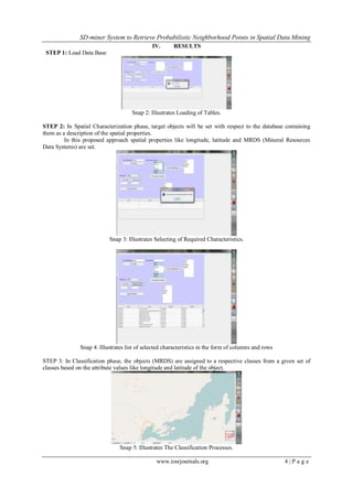
![SD-miner System to Retrieve Probabilistic Neighborhood Points in Spatial Data Mining
www.iosrjournals.org 5 | P a g e
STEP 4: clustering classifies spatial objects (MRDS) as multiple groups according to specified longitude and
latitude.
Table 1: Illustrating number of clusters vs. Range
Graph: Number clusters vs. Range
The above table and graph shows us the variations of clusters according to the given range. As and
when we change the parameters longitude and latitude the number of clusters will change, because it searches
for the specified characteristic in the given range.
V. Conclusion
Spatial data has positional and topological data that do not exist in general data, and its structure is different
according to the kinds of spatial data. Also, the objects on space affect each other and the relationship of objects is also
different according to the kinds of objects. There have been many researches on spatial data mining considering these
characteristics of spatial data.
In this work, author explains the concept of spatial clustering, spatial classification, spatial characterization, and
spatio-temporal association rule mining. We present our experiences in developing a spatial data mining system called SD-
Miner that provides proper spatial data mining techniques with improved effectiveness and efficiency for real applications.
SD-Miner adopts following techniques. For spatial clustering, proposed system adapt NN Superseeding algorithm. For
spatial characterization, proposed system uses a binary decision tree and the RELIEF algorithm for efficiency. For spatial
characterization, we use the neighbor table for spatial extension of the current characterization method. For spatio-temporal
association rule mining, we use temporal data with spatial association rule mining using the spatial concept layer. SD-Miner
uses spatial data mining functions extended from general mining functions. So, it can be applied to both of spatial and non-
spatial data. Without special intervention of a user, it automatically recognizes which type of data is used. All functions are
developed in library style, and the functions can be reused in another system.
References
[1] SD-Miner: A SPATIAL DATA MINING SYSTEM Duck-Ho Bae, Ji-Haeng Baek, Hyun-Kyo Oh, Ju-Won Song, Sang-Wook Kim
[2] J. Sander et al., “Density-Based Clustering in Spatial Databases: The Algorithm GDBSCAN and Its Applications,” Data Mining
and Knowledge Discovery, Vol. 2, No. 2, pp. 169-194, 1998
[3] M. Ester et al., “Algorithms for Characterization and Trend Detection in Spatial Databases,” In Proc. Int'l. Conf. on Knowledge
Discovery and Data Mining, KDD, pp. 44-50, 1998.
[4] K. Koperski, J. Han, and N. Stefanovic, “An Efficient Two-Step Method for Classification of Spatial Data,” In Proc. Int'l. Symp. On
Spatial Data Handling, SDH, pp. 45-54, 1998.
[5] Spatio-Temporal Data Mining On Moving Objects In DBMS Yahaya Bin Abd Rahim GIS Section OTB Research Institute for
Housing, Urban and Mobility Studies Delft University of Technology November 15 2007.
[6] M. Ester et al., “Spatial Data Mining: Database Primitives, Algorithms and Efficient DBMS Support,” Data Mining and Knowledge
Discovery, Vol. 4, pp. 193-216, 2000.
[7] M. Ester, H. Kriegel, and J. Sander, “Algorithms and Applications for Spatial Data Mining,” Geographic Data Mining and
Knowledge discovery, 2001.
[8] J. Han, K. Koperski, and N. Stefanovic, “GeoMiner: A System Prototype for Spatial Data Mining,” In Proc. ACM Int'l. Conf. on
Management of Data, ACM SIGMOD, pp. 553-556, 1997.
[9] W. Lu, J. Han, and B. Ooi, “Discovery of General Knowledge in Large Spatial Databases,” In Proc. Far East Workshop on
Geographic Information Systems, pp. 275-289, 1993.
[10] E. Knorr and R. Ng, “Finding Aggregate Proximity Relationships and Commonalities in Spatial Data Mining,” IEEE Trans. On
Knowledge and Data Engineering, IEEE TKDE, Vol. 8, pp. 884-897, 1996.
Number of
clusters
Range in meters
1 1000
4 2000
8 3000
25 4000
30 5000
38 6000
45 7000
52 8000
65 9000
71 10000](https://image.slidesharecdn.com/a0460105-131001012457-phpapp02/85/SD-miner-System-to-Retrieve-Probabilistic-Neighborhood-Points-in-Spatial-Data-Mining-5-320.jpg)

The document describes a proposed spatial data mining system called SD-Miner. SD-Miner consists of three main parts: a graphical user interface, an SD-Miner module for processing spatial data mining functions, and a data storage module. The SD-Miner module provides four spatial data mining functionalities: spatial clustering, spatial classification, spatial characterization, and spatio-temporal association rule mining. The document presents the architecture of SD-Miner and provides examples of using it to perform spatial clustering, classification, and characterization on spatial data from a database.


![[IJET-V1I3P9] Authors :Velu.S, Baskar.K, Kumaresan.A, Suruthi.K](https://cdn.slidesharecdn.com/ss_thumbnails/ijet-v1i3p9-150603165341-lva1-app6892-thumbnail.jpg?width=640&height=640&fit=bounds)