Download to read offline
![Ms.D.N.Rajeswari et al Int. Journal of Engineering Research and Applications
ISSN : 2248-9622, Vol. 3, Issue 6, Nov-Dec 2013, pp.957-962
RESEARCH ARTICLE
www.ijera.com
OPEN ACCESS
A Novel Approach of Content Based Image Retrieval Improved
Segmentation Algorithm for Satellite Based Images
Ms. D.N.Rajeswari1, Ms.R.Deepthi2
1
2
Andhra Loyola Institute of Engineering and Technology
Andhra Loyola Institute of Engineering and Technology
Abstract
Now a days, satellite images plays a vital role in environmental monitoring, geological survey, and disaster
forecasting and other applications. Due to the demand presence regarding remotely sensed images, many image
based satellites have been launched. Each of the image based satellite produces different set of categorized
images of which we require the image with Complete JPEG or high definition based image format. So as to
process such type of images, we use a technique called image retrieval technique CBIR (content –based image
retrieval) which gives semantic gap between low level features and high level concepts. Regional and semantic
features of this type are combined to produce narrow semantic gap. In order to understand image content by
region, proposal of a region level semantic based image retrieval system approach is used along with improved
segmentation algorithm. Then uniform region based representation for each image is built. Based on region level
features, a probabilitistic relationship among image, region and hidden semantic feature is developed.
Expectation maximization method is used to mine the hidden features. Experimental results for proposed
improved segmentation algorithm give better segmentation and retrieval precision than earlier multiple future
fusion based algorithm.
Keywords-- Satellite based Images, Content Based Image Retrieval (CBIR), Improved Segmentation
Algorithm.
techniques content based image retrieval has become
important tool for image exploration. Content-based
I.
INTRODUCTION
image retrieval, a technique which uses visual
As satellite images are widely used, number
contents to search images from large scale image
of countries operates satellites which collect images
databases according to user’s interests.
of earth for commercial purposes. The term Satellite
In CBIR system low-level features are used
simply refers to a body in orbit around another body.
to represent image content and retrieve image form
Remote sensing is a module which focuses on Earth
database but they cannot easily utilized to describe
observation from airborne or space borne platforms.
users perception of image. The semantic gap is the
Radiation reflected or emitted from earth surface is
lack of coincidence between the information that one
converted to signal .The reflectance from a feature
can extract from the visual data and the interpretation
depends on the atmospheric conditions, seasons, time
that the same data have for a user in a given situation.
of a day, and physical and chemical characteristics of
User seeks semantic similarity, but the database can
the feature. Selection of a remote sensing system is a
only provide similarity by data processing.
compromise between spectral characteristics of
Semantic feature mining is essential and
surface being sensed and spectral characteristics of
performed based upon low level feature extraction
surface being sensed. Remote sensing used in many
and high level semantic feature extraction. Low level
applications like Land-use mapping ,Forest and
feature based on pixel characteristics. Li and
agriculture
applications,
Telecommunication
Narayanan[1] identified ground coverage information
planning, Environmental applications, Hydrology and
based on spectral characteristics using supervised
coastal mapping and Urban planning. Therefore, how
classification and extracted textural features by
to retrieve an useful image fastly and accurately from
characterizing spatial information using wavelet
a huge database becomes a challenge.
coefficients. Pixel level textural information to extract
At the time many researches taken place
global information does not give understanding of
,there are different image query techniques used to
image thus it is often replaced with region level
retrieve images by matching keywords, such as
description of visual information.
geographic location, sensor type, and time of
A group of connected pixels with similar
acquisition but content of image which has more
properties taken as region. For correct interpretation,
priority than attributes such as width, height, number
image must be partitioned into regions that
of frames is not considered in these techniques. So to
correspond to objects or parts of an object.
overcome the difficulties present in traditional
Partitioning into regions done often by using gray
www.ijera.com
957 | P a g e](https://image.slidesharecdn.com/fd36957962-131127003908-phpapp01/75/Fd36957962-1-2048.jpg)
![Ms.D.N.Rajeswari et al Int. Journal of Engineering Research and Applications
ISSN : 2248-9622, Vol. 3, Issue 6, Nov-Dec 2013, pp.957-962
www.ijera.com
values of the image pixels. By far, datcu et al.[2] and
dascheil and datcu[3] ,aksoy et al[5] proposed pixel
based Bayesian framework for narrow the semantic
gap between low level features and high level
concepts. So, to address the limitations in previous
concepts, a novel approach is proposed to achieve
region level semantic feature mining. Here, steps need
to be follow for remotely sensed image retrieval is
performed using region level is, identifying the region
level image content to facilitate users perception then
give a probability relationship among image, region,
and hidden semantic features. Then, Expectation
maximization(EM) method is used to mine the hidden
semantic features.
II.
REGION –LEVEL IMAGE
REPRESENTATION USING JSEG
ALGORITHM
Regional level image representation has
these components: image segmentation, regional
information description and codebook extraction.
Region-based methods mainly rely on the assumption
that the neighboring pixels within one region have
similar value. The common procedure is to compare
one pixel with its neighbors. If a similarity criterion is
satisfied, the pixel can be set belong to the cluster as
one or more of its neighbors. The selection of the
similarity criterion is significant and the results are
influenced by noise in all instances.
Fig 1: Original JSEG algorithm schematic diagram
Image segmentation based on region level
performed by following two segmentation methods:
JSEG and GrabCut.JSEG is based on the concept of
region-growing. But Grab-Cut is interactive
foreground/background segmentation in image. In
this paper, we focused on JSEG algorithm.
The concept of the JSEG algorithm is to
separate the segmentation process into two portions,
color quantization and spatial segmentation. The color
quantization quantizes colors in image into several
representative classes that can differentiate regions in
the image. The process of quantization is
implemented in the color space without considering
the spatial distribution of the colors. The
corresponding color class labels replace the original
pixel values and then create a class-map of the image.
Step 1: Calculate local j values: A color quantization
algorithm is applied to image. Each pixel is assigned
its corresponding color class label.
a) Estimate region by J value: J=(ST –SW)/SW
; Where ST and SW are an variance.
b) Total variance: ST=∑ ||Z-m||2 where z is
coordinate and m is mean of coordinate.
c) Mean of variance of each class SW=∑
Si=∑∑||Z-m||2
where mi is the mean
coordinate of class Zi.
d) Segmented class-map and value J=1/N ∑
M KJ K
Step 2: Seed Determination
a) Compute the average and the standard
deviation of the local J values.
b) Set threshold TJ=µJ + ασJ
www.ijera.com
958 | P a g e](https://image.slidesharecdn.com/fd36957962-131127003908-phpapp01/75/Fd36957962-2-2048.jpg)
![Ms.D.N.Rajeswari et al Int. Journal of Engineering Research and Applications
ISSN : 2248-9622, Vol. 3, Issue 6, Nov-Dec 2013, pp.957-962
c)
Pixels with local J values less than TJ are set
as candidate seed points.
d) Associate candidate seed points as seed area
if its size larger
Tabular representation for finding seed:
Table 1: Finding min. seed and region size
Step 3: Seed Growing
a) Remove “holes” in the seed areas.
b) Compute the average of the local J values in the
remaining un-segmented part of the region.
c) Connect pixels below the average to compose
growing areas.
d) If a growing area is adjacent to one and only one
seed, we merge it into that seed.
e) Compute local J values of the remaining unsegmented pixels at the next smaller scale and repeat
region growing.
f) At the smallest scale, the remaining pixels are
grown one by one.
Step 4: In spatial segmentation step, region growing
method is used to segment image based on J-image,
in which a threshold controls region growing result.
In this, 0.5 is chosen as an empirical value.
III.
PROPOSED SYSTEM
ARCHITECTURE
Fig 2: Flow chart of improved image
segmentation algorithm
www.ijera.com
www.ijera.com
A. Image: sensors present in satellite, measures the
amount of variability of the the light source. It filters
the light coming to it along the path way.What is
actually being measured in sensor systems is spectral
radiance or the radiant energy from the target. .
According to the law of energy conservation, a part of
the radiant energy that arrives to the object is
absorbed. The radiosity represents the light that
leaves a diffuse surface (Forsyth & Ponce, 2002).
This way an image is acquired
B. NDVI Calculation: It is normalized difference
vegetation index, used to measure green biomass
(Tucker, 1979).NDVI is calculated from the visible
and near-infrared light reflected by vegetation.
Healthy vegetation absorbs visible light and reflects a
large portion of the near-IR light. Unhealthy or sparse
vegetation reflects more visible light and less near-IR
light. A typical reflectance spectrum of a vegetation
can be subdivided into 3 parts, visible (0.40 – 0.70
μm), near infrared NIR (0.701 – 1.3 μm) and middleinfrared (1.301 – 2.5 μm). NDVI is calculated using
an equation
(1)
Where VIS, NIR stands for spectral reflectance
acquired in the visible (red) and near infrared region.
For land targets the index ranges from values close to
0 for arid or barren areas to ~ 1 for densely vegetated
areas. Negative values of NDVI usually correspond to
urban areas. The NDVI over water surfaces is very
close to -1 due to their very low reflectance in the
NIR band.
C. NDBI Calculation: Normalized Difference built up
Index used to compare urban areas with built up areas
between satellite images, it can be calculated as
(2)
Where MIR and NIR stands for spectral
reflectance measurements acquired in the middle
infrared and near infrared regions. The middleinfrared region (1.301μm - 2.5μm) contains
information about the absorption of radiation by
water, cellulose and lignin and several other
biochemical constituents.
Texture reflects the local variability of grey level
in the spatial domain and reveals the information
about the object structures in the natural environment
[26]. Grey-Level Co-occurrence Matrix (GLCM),
which is commonly applied in statistical procedure
for interpreting texture. Finally, the pixels in original
image can be represented as Equation
f = {fNDVI, fNDBI, ftexture} ;
(3)
D. GLCM: Texture is used to estimate the boundaries
of objects. Since the repetitive local arrangement of
intensity determines the texture, to analyze
neighborhoods of pixels, to measure texture
959 | P a g e](https://image.slidesharecdn.com/fd36957962-131127003908-phpapp01/75/Fd36957962-3-2048.jpg)
![Ms.D.N.Rajeswari et al Int. Journal of Engineering Research and Applications
ISSN : 2248-9622, Vol. 3, Issue 6, Nov-Dec 2013, pp.957-962
www.ijera.com
Using Bayesian formula ,class conditional probability
P(sk|ri,di)= P(dj|sk)P(ri|sk)P(sk)
p(dj)∑K
K
=1
p(ri|sk)P(sk|dj)
(10)
We have reduced the problem of selecting
the best model to that of selecting the best parameter
and want to select a parameter p which will maximize
the probability that the data was generated from the
model with the parameter p plugged-in. The
parameter p is called the maximum likelihood
estimator. The maximum of the function can be
obtained by setting the derivatives of the function ==0
and solving for p.
Maximum likelihood function: L=log(P(R,D,S))
=∑i=1N∑i=1MP(sk|ri,di) log[P(sk,dj)P(ri|sk)]
Standard procedure for maximum likelihood
estimation depends on E-step which can be
interpreted as mining the relationship between current
estimates of the parameters and the latent variables by
computing posterior probabilities .M-step can be
interpreted as updating parameters based on the so
called expected complete data –likelihood.
P(ri|sk) =
∑Mj=1 n(ri,dj) P(sk|ri,dj)
∑N m=1
P(sk|dj)=
∑M j=1 n(rm,dj)P(sk|rm,dj)
∑N i=1 n(ri,dj)P(sk|ri,dj)
∑N n=1 n(rn,dj)
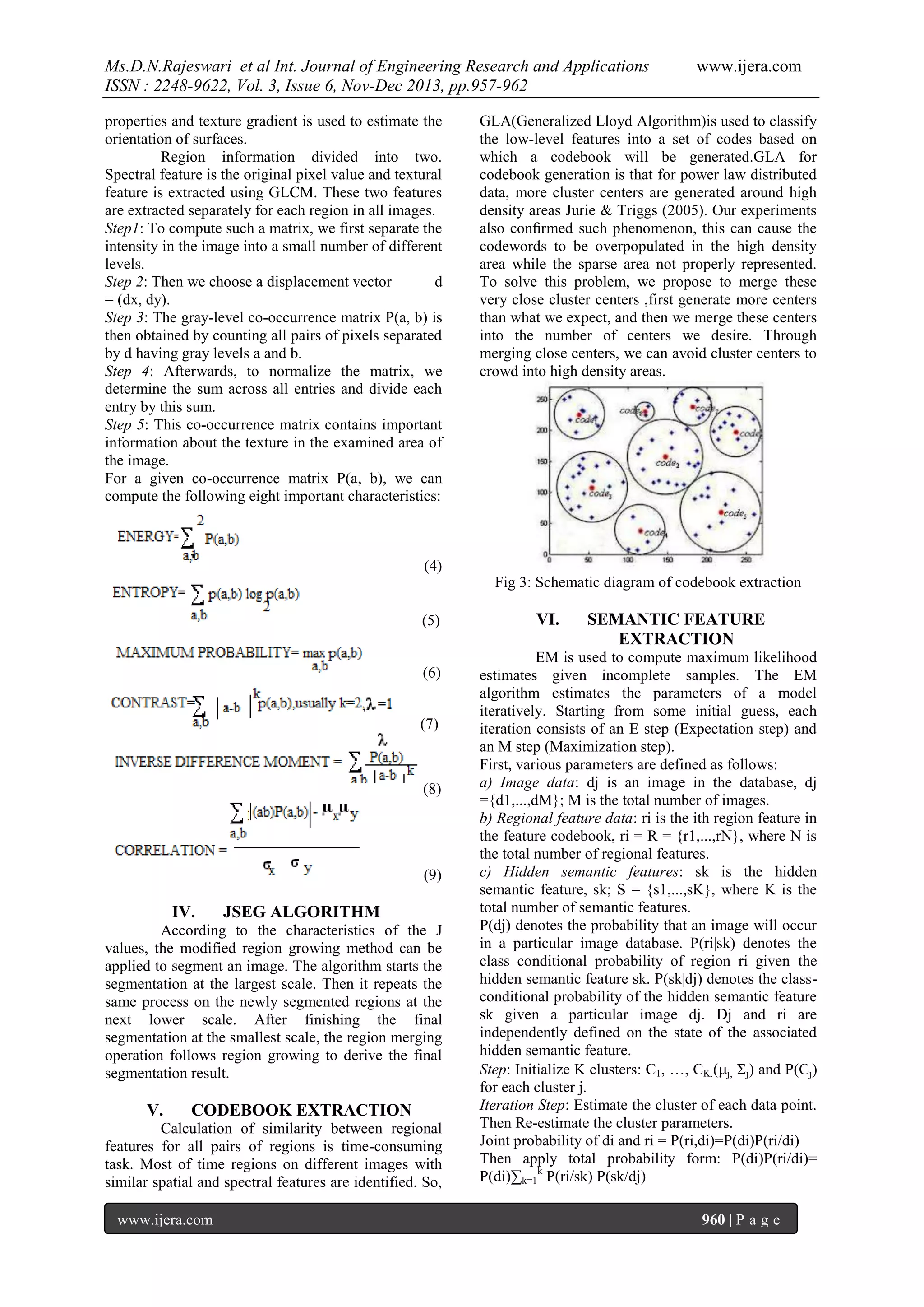
VII.
Fig 4: Images A,B and their segmentation results
using JSEG algorithm
(11)
EXPERIMENTAL RESULTS
Different scenes of TM images are utilized,
Each image is split into small size of 256*256, and
total number of small size images is 2500. After
preprocessing, each image and its features are stores
in the image database. In this image database, each
image is classified into seven concepts: cloud, sea,
river, mountain, urban area, farm land, bare soil.
A. Image segmentation
JSEG: Color quantization threshold - specify values
0-600, leave blank for automatic determination. The
higher the value, the less number of quantized colors
in the image. For color images, try 250. If you are
unsatisfied with the result because two neighboring
regions with similar colors are not getting separated,
please try a smaller value say 150a) Number of scales
- The algorithm automatically determines the starting
scale based on the image size and reduces the scale to
Refine the segmentation results. If you want to
segment a small object in a large-sized image, use
more number of scales. If you want to have a coarse
segmentation, use 1 scale only .Region merge
threshold specify values 0.0-0.7, leave blank for
default value 0.4. If there are two neighboring regions
having identical color, try smaller values to avoid the
merging.
www.ijera.com
Fig 5: Semantic feature extraction
(a)
(b)
Fig 10 : a) image covers mountain and urban area b)
top 20 results.
961 | P a g e](https://image.slidesharecdn.com/fd36957962-131127003908-phpapp01/75/Fd36957962-5-2048.jpg)
![Ms.D.N.Rajeswari et al Int. Journal of Engineering Research and Applications
ISSN : 2248-9622, Vol. 3, Issue 6, Nov-Dec 2013, pp.957-962
VIII.
Where Irrelevant is the total number of
relevant images, and I retrieved is the total number of
retrieved images. When the numbers of total retrieved
images are 10, 20, 30, and 40, respectively. Although
the precision and recall of first experiment are much
higher than those of second experiment.
www.ijera.com
CONCLUSION
Different image query techniques are used to
retrieve images, to overcome the difficulties present
in traditional retrieval techniques content based image
retrieval has become tool for image exploration. In
CBIR system, cannot easily utilized to describe users
perception of image. Semantic gap occur due to the
lack of coincidence between the information that one
can extract from the visual data and the interpretation
that the same data given for a user. Regional and
semantic features are combined to narrow semantic
gap. Improved segmentation algorithm along with
Expectation maximization method gives better
precision results.
REFERENCES
[1]
[2]
[3]
[4]
Fig 11:The precision results for different number of
retrieved images taken above.
[5]
[6]
[7]
[8]
Fig 12: The recall results for different number of
retrieved images taken above.
www.ijera.com
Li J, Narayanan RM: Integrated spectral and
spatial information mining in remote sensing
imagery. IEEE Trans Geosci Remote Sens
2004,42(3):673-685.
Datcu M, Daschiel H, Pelizzari A, Quartulli
M, Galoppo A, Colapicchioni A,Pastori M,
Seidel K, Marchetti PG, D’Elia S:
Information mining in remote sensing image
archives: system concepts. IEEE Trans
Geosci Remote Sens2003, 41(12):29232936.
Daschiel H, Datcu M: Design and evaluation
of human-machine communication for image
information mining. IEEE Trans Multimedia
2005, 7(6):1036-1046.
Deng YN, Manjunath BS: Unsupervised
segmentation of color-texture regions in
images and video. IEEE Trans Pattern Anal
Mach Intell 2001,23(8):800-810.
Aksoy S, Koperski K, Tusk C, Marchisio G,
Tilton JC: Learning Bayesian classifiers for
scene classification with a visual grammar.
IEEE Trans GeosciRemote Sens 2005,
43(3):581-589.
Bimbo AD: Visual Information Retrieval
Morgan 19. Wang ZY, Boesch R: Color- and
texture-based image segmentation for
improved forest delineation. IEEE Trans
Geosci Remote Sens 2007,45(10):30553062.
Chang Y, Lee D, Wang Y: Color-texture
segmentation of medical images based on
local contrast information. Proc IEEE
Symposium on Computational Intelligence
and Bioinformatics and Computational
Biology Honolulu, HI; 2007, 488-493.
Han JW, Ngan KN: Automatic segmentation
of objects of interest in video: a unified
framework. Proceeding of 2004 Intelligent
Signal Processing and Communication
Systems (ISPACS) Seoul, South Korea;
2004, 375-378.
962 | P a g e](https://image.slidesharecdn.com/fd36957962-131127003908-phpapp01/75/Fd36957962-6-2048.jpg)

The document discusses a novel content-based image retrieval (CBIR) approach that utilizes an improved segmentation algorithm for satellite images, focusing on reducing the semantic gap between low-level features and high-level concepts. It outlines the use of region-level image representation and expectation maximization to achieve better segmentation and retrieval precision compared to previous methods. Experimental results indicate that the proposed method performs effectively for various applications, including environmental monitoring and urban planning.


![[IJET-V1I3P9] Authors :Velu.S, Baskar.K, Kumaresan.A, Suruthi.K](https://cdn.slidesharecdn.com/ss_thumbnails/ijet-v1i3p9-150603165341-lva1-app6892-thumbnail.jpg?width=640&height=640&fit=bounds)