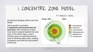
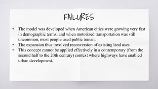
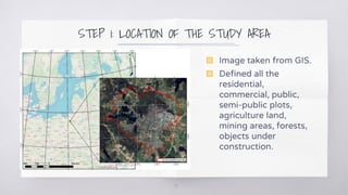
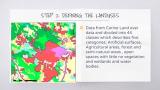
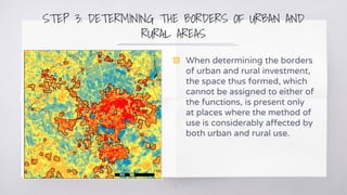
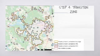
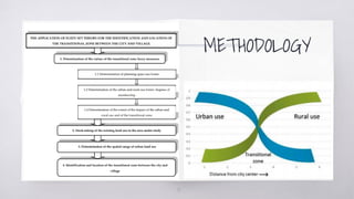
ZONE OF
TRANSITION
TRANSITION ZONE: By some authors
In 1967, Zaremba, defined the transitional zone between rural and urban
area as “off-town areas”, whose characteristic features include: Sparsely
built-up area, intensively used horticultural farms, incomplete communal
infrastructure, sparsely situated industrial and warehousing facilities, and
sports and leisure greenery. These areas are also regarded as temporary
(transitional) form of the land use, preceding the phase of more intense
building development. The transitional zone can also be regarded as the
border zone, which covers a structurally non-uniform area of direct
contact of urban investment and open land, associated with a different
extent and during different periods with the presence of the administrative
border of the town.
2
TRANSITION ZONE: By some authors
According to Słodczyk , there are forms and functions typical of rural and
urban areas that inter-permeate in the transitional zone formed on the
outskirts of a developing town. It is an area situated in the immediate
vicinity of the town, linked with the town in a variety of ways and steadily
transformed as a result of these links.
3
DEFINITION
• Transition areas as the space (not necessarily empty) between areas
with single-family homes and areas with commercial buildings.
• In transition areas, the size and height of buildings generally get
smaller as you move away from commercial areas into neighborhood
residential areas.
• Transition zones are the zoning categories assigned to parcels or lots in
a transition area.
4
HISTORICAL EVOLUTION
OF
TRANSITION ZONES
5
6
According to Burgess Urban Land Use
Model:
Urban growth is a process
of expansion and reconversion of
land uses, with a tendency of each
inner zone to expand towards the outer
zone. In the shown figure, zone II
(Factory zone) is expanding towards
zone IV (Working class zone), creating
a transition zone with the reconversion
of land use.
1. CONCENTRIC ZONE MODEL
BY: BURGESS MODEL
7
• The model was developed when American cities were growing very fast
in demographic terms, and when motorized transportation was still
uncommon, most people used public transit.
• The expansion thus involved reconversion of existing land uses.
• This concept cannot be applied effectively in a contemporary (from the
second half to the 20th century) context where highways have enabled
urban development.
FAILURES
CASE STUDY:
Olsztyn, Poland
8
STEP 1: LOCATION OF THE STUDY AREA
9
▧ Image taken from GIS.
▧ Defined all the
residential,
commercial, public,
semi-public plots,
agriculture land,
mining areas, forests,
objects under
construction.
STEP 2: DEFINING THE LANDUSES
10
▧ Data from Corine Land over
data and divided into 44
classes which describes five
categories: Artificial surfaces,
Agricultural areas, forest and
semi-natural areas , open
spaces with little no vegetation
and wetlands and water
bodies.
STEP 3: DETERMINING THE BORDERS OF URBAN AND
RURAL AREAS
11
▧ When determining the borders
of urban and rural investment,
the space thus formed, which
cannot be assigned to either of
the functions, is present only
at places where the method of
use is considerably affected by
both urban and rural use.
STEP 4: TRANSITION
ZONE
12
METHODOLOGY
13
ELEMENTS OF ZONING:
14
15
▧ Railway Lines
▧ Roads
▧ Public gardens
▧ Parks
▧ Canals/ Rivers/
Playgrounds
▧ Fire station like
essential services
▧ Bus stand
▧ Government offices
& Premises
16
PRINCIPLES OF ZONING:
17
18
▧ Arrangement of zones
▧ Boundaries
▧ Existing towns
▧ Flexibility
▧ New towns
Thanks!
BY: SIMRAN AGGARWAL
MURP-1(2020-22)
FACULTY OF PLANNING, SUPVA
19

Zone of transition

  • 1.
  • 2.
    TRANSITION ZONE: Bysome authors In 1967, Zaremba, defined the transitional zone between rural and urban area as “off-town areas”, whose characteristic features include: Sparsely built-up area, intensively used horticultural farms, incomplete communal infrastructure, sparsely situated industrial and warehousing facilities, and sports and leisure greenery. These areas are also regarded as temporary (transitional) form of the land use, preceding the phase of more intense building development. The transitional zone can also be regarded as the border zone, which covers a structurally non-uniform area of direct contact of urban investment and open land, associated with a different extent and during different periods with the presence of the administrative border of the town. 2
  • 3.
    TRANSITION ZONE: Bysome authors According to Słodczyk , there are forms and functions typical of rural and urban areas that inter-permeate in the transitional zone formed on the outskirts of a developing town. It is an area situated in the immediate vicinity of the town, linked with the town in a variety of ways and steadily transformed as a result of these links. 3
  • 4.
    DEFINITION • Transition areasas the space (not necessarily empty) between areas with single-family homes and areas with commercial buildings. • In transition areas, the size and height of buildings generally get smaller as you move away from commercial areas into neighborhood residential areas. • Transition zones are the zoning categories assigned to parcels or lots in a transition area. 4
  • 5.
  • 6.
    6 According to BurgessUrban Land Use Model: Urban growth is a process of expansion and reconversion of land uses, with a tendency of each inner zone to expand towards the outer zone. In the shown figure, zone II (Factory zone) is expanding towards zone IV (Working class zone), creating a transition zone with the reconversion of land use. 1. CONCENTRIC ZONE MODEL BY: BURGESS MODEL
  • 7.
    7 • The modelwas developed when American cities were growing very fast in demographic terms, and when motorized transportation was still uncommon, most people used public transit. • The expansion thus involved reconversion of existing land uses. • This concept cannot be applied effectively in a contemporary (from the second half to the 20th century) context where highways have enabled urban development. FAILURES
  • 8.
  • 9.
    STEP 1: LOCATIONOF THE STUDY AREA 9 ▧ Image taken from GIS. ▧ Defined all the residential, commercial, public, semi-public plots, agriculture land, mining areas, forests, objects under construction.
  • 10.
    STEP 2: DEFININGTHE LANDUSES 10 ▧ Data from Corine Land over data and divided into 44 classes which describes five categories: Artificial surfaces, Agricultural areas, forest and semi-natural areas , open spaces with little no vegetation and wetlands and water bodies.
  • 11.
    STEP 3: DETERMININGTHE BORDERS OF URBAN AND RURAL AREAS 11 ▧ When determining the borders of urban and rural investment, the space thus formed, which cannot be assigned to either of the functions, is present only at places where the method of use is considerably affected by both urban and rural use.
  • 12.
  • 13.
  • 14.
  • 15.
    15 ▧ Railway Lines ▧Roads ▧ Public gardens ▧ Parks ▧ Canals/ Rivers/ Playgrounds ▧ Fire station like essential services ▧ Bus stand ▧ Government offices & Premises
  • 16.
  • 17.
  • 18.
    18 ▧ Arrangement ofzones ▧ Boundaries ▧ Existing towns ▧ Flexibility ▧ New towns
  • 19.