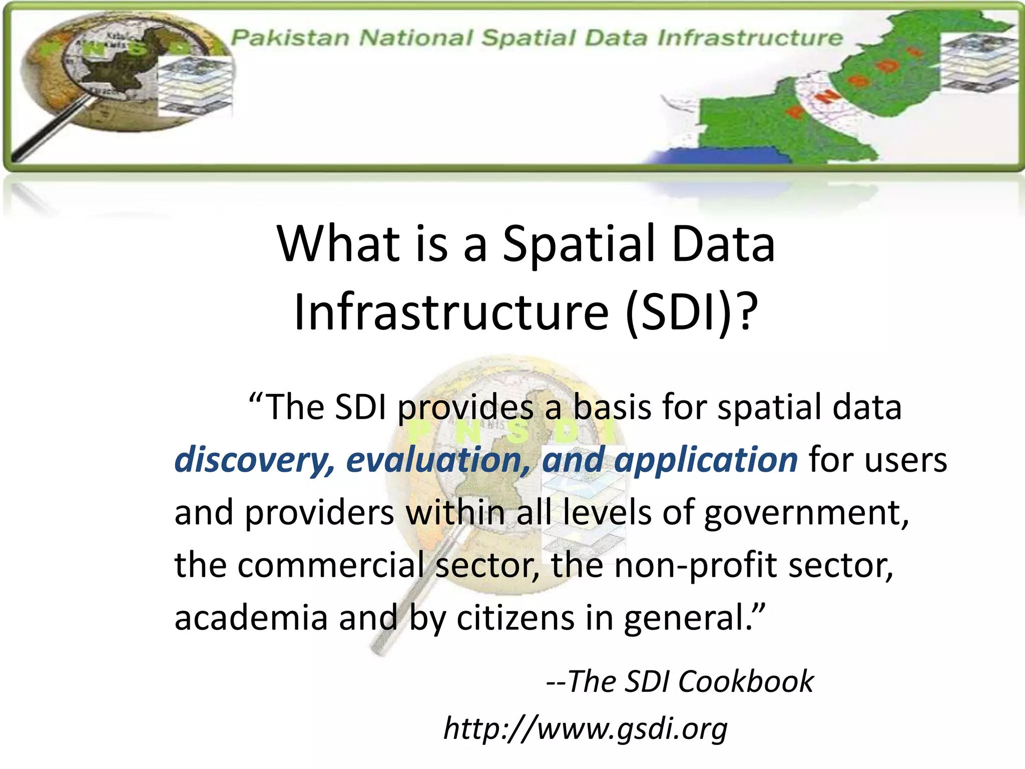
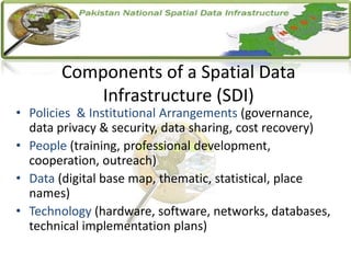
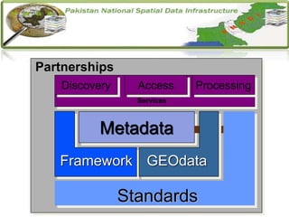
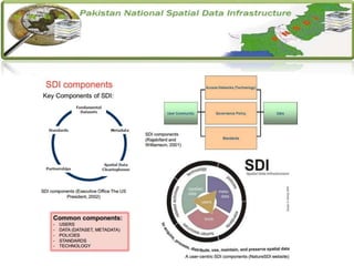
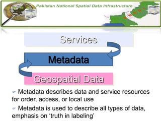
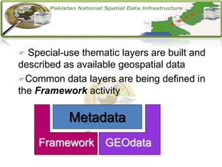
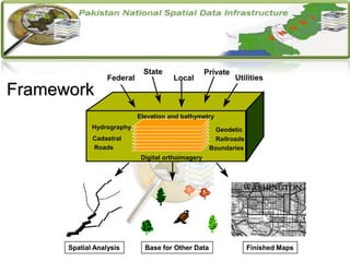
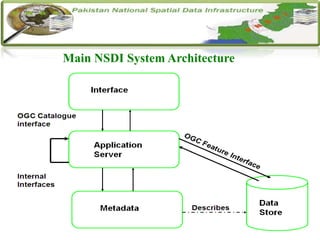
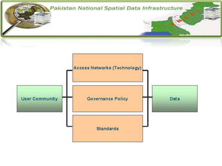
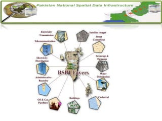
SlideShare a Scribd company logo
1 of 26
What is a Spatial Data
Infrastructure (SDI)?
“The SDI provides a basis for spatial data
discovery, evaluation, and application for users
and providers within all levels of government,
the commercial sector, the non-profit sector,
academia and by citizens in general.”
--The SDI Cookbook
http://www.gsdi.org
Introduction
• National Spatial Data Infrastructure for the availability of and
access to organized spatial data, use of Spatial Data Infrastructure
at Local, State, Regional and National level for sustained
economic growth.
• Convincing the Stakeholders involved Data Collection and
Sharing Standards, Major Institutions and Technical Aspects
involved in the study ensure the successful implementation of
NSDI.
• It is explaining the web base NSDI data management and sharing
among the different enterprises under the specific standards.
Components of a Spatial Data
Infrastructure (SDI)
• Policies & Institutional Arrangements (governance,
data privacy & security, data sharing, cost recovery)
• People (training, professional development,
cooperation, outreach)
• Data (digital base map, thematic, statistical, place
names)
• Technology (hardware, software, networks, databases,
technical implementation plans)
Reasons to Transfer GIS into SDI
As SDI provides access and data sharing,
Interoperability, Local Management, Portability
Reasons are:
• Non-usability of GIS
• Market growth for GI(S) industry
• Government initiatives at all levels
• Economic pressure to recover investments
Scope
Major focus in this project will be on exploring
the available solutions for defining the NSDI
extent and techniques and methods available for
delineating different aspects specifically
Institutional, Technical aspects.
Objective
The main objective of NSDI is development of
spatial data databases and direct transfer of those
data between state institutions, local and regional
self-government, public system and economy
altogether oriented towards user needs.
Components of NSDI
• The components of SDI provides framework of
spatial data, metadata, users and tools that are
interactively connected in order to use spatial data in
an efficient and flexible way.
• Main components are listed below:
Metadata
GEOdata
Clearinghouse (catalog)
Framework
Standards
Partnerships
Metadata
Standards
Partnerships
Discovery Access
Services
Processing
Framework GEOdata
Metadata
 Metadata describes data and service resources
for order, access, or local use
 Metadata is used to describe all types of data,
emphasis on ‘truth in labeling’
Metadata
Geospatial Data
Services
 Special-use thematic layers are built and
described as available geospatial data
Common data layers are being defined in
the Framework activity
Metadata
Framework GEOdata
Digital orthoimagery
Elevation and bathymetry
Boundaries
Railroads
Geodetic
Federal
State
Local
Private
Utilities
Spatial Analysis Base for Other Data Finished Maps
Roads
Cadastral
Hydrography
Spatial Analysis Base for Other Data Finished Maps
Framework
Main NSDI System Architecture
Institutional Frameworks
The framework is a collaborative community based
effort in which these commonly needed data themes
are developed, maintained, and integrated by public
and private organizations within a geographic area
Enterprise under study:
Department of Solid Waste Management.
Department of Education.
Institutional Frameworks
GIS-Based Analysis determined for SWM:
o Proper Allocation and Relocation of waste bins
o New disposal site selection using a Multi-Criteria Decision Analysis.
o Estimation of Municipal waste generation, collection and Determination of Waste
generation.
o GIS-based Transportation Model for Solid Waste disposal.
o Analysis and Monitoring of Waste Flow.
o Selection of Collection Points (Interface between Primary and Secondary Collection)
and their Distribution.
o Cost Effectiveness Analyses against Different Collection Options for different Areas.
o Transfer Station Site Selection for long distances
o Composting, Incinerator and Recycling Site Selection
o Future Forecasting of Solid Waste Generation for Anticipation to deal Consequences
Suggestion for Base Layers for SWM:
 Boundary
 Roads
 Railways Crossings
 Water Bodies
 Landmarks
Capacity Building:
The development of knowledge, skills and attitudes in
individuals and groups of people relevant in design,
development, management and maintenance of institutional
and operational infrastructures and processes that are locally
meaningful
Motivation provided to SWM Department towards NSDI.
Identified their problems and provided solutions under NSDI.
System Implementation
We have designed the PNSDI (Pakistan National
Spatial Data Infrastructure) for the clients to the
better and direct access to the Spatial Data at
National Level, as it includes the Servers of Federal
Enterprises which has all the detail of the
Enterprises.
Prototype for PNSDI
NSDI WEBSITE
Login
Search for
Spatial Data
(NSDI
Metadata
server)
Pre-view
Spatial data
(NSDI Data
Servers)
Download
Spatial data
(NSDI Data
Servers)
Secure access
Gateway
Secure access
Gateway
GIS Applications
PNSDI PROTOTYPE
Define Require
Data
Place Order
for
Download
Prototype for PNSDI
NSDI WEBSITE
Login
Search for
Spatial Data
(NSDI
Metadata
server)
Pre-view
Spatial data
(NSDI Data
Servers)
Download
Spatial data
(NSDI Data
Servers)
Secure access
Gateway
Secure access
Gateway
GIS Applications
PNSDI PROTOTYPE
Define Require
Data
Place Order
for
Download
Main Interface of System
• In our project, we have tried our best to suggest NSDI for Pakistan. This thesis provides the basic
framework and roadmap for the implementation of this system in reality. This provides the open
geospatial platform for any user to access the spatial data related to different enterprise.
• This study provide new horizons for the best access to data we have covered all the aspect related
to server end up to client end based on conceptual and logical designing. The diagrammatic
notations provide the better way to understanding the whole system for the other people.
• We have worked on institutional & technical aspects but up to some extent. In future we can also
work on these following aspects of NSDI:
• Appreciation Aspect
• Institutional Aspect
• Technical Aspect
• Implementation Aspect
• Monitoring and Controlling Aspect
• Legal Aspect
• Economic Aspect
• Educational Aspect
FUTURE DIRECTIONS

More Related Content

What's hot

What's hot (20)

NSDI_ Concepts and Components
NSDI_ Concepts and ComponentsNSDI_ Concepts and Components
NSDI_ Concepts and Components
 
Geographic information system (gis)
Geographic information system (gis)Geographic information system (gis)
Geographic information system (gis)
 
A Journey to the World of GIS
A Journey to the World of GISA Journey to the World of GIS
A Journey to the World of GIS
 
GIS based Decision Support System
GIS based Decision Support SystemGIS based Decision Support System
GIS based Decision Support System
 
Geodatabase: The ArcGIS Mechanism for Data Management
Geodatabase: The ArcGIS Mechanism for Data ManagementGeodatabase: The ArcGIS Mechanism for Data Management
Geodatabase: The ArcGIS Mechanism for Data Management
 
Geoprocessing
GeoprocessingGeoprocessing
Geoprocessing
 
Geodatabases
GeodatabasesGeodatabases
Geodatabases
 
DTM DEM Generation
DTM DEM GenerationDTM DEM Generation
DTM DEM Generation
 
Land use and land cover classification
Land use and land cover classification Land use and land cover classification
Land use and land cover classification
 
Introduction to GIS
Introduction to GISIntroduction to GIS
Introduction to GIS
 
GIS - Project Planning and Implementation
GIS - Project Planning and ImplementationGIS - Project Planning and Implementation
GIS - Project Planning and Implementation
 
Gis georeference
Gis georeferenceGis georeference
Gis georeference
 
Chap1 introduction to geographic information system (gis)
Chap1 introduction to geographic information system (gis)Chap1 introduction to geographic information system (gis)
Chap1 introduction to geographic information system (gis)
 
GIS
GISGIS
GIS
 
GIS data structure
GIS data structureGIS data structure
GIS data structure
 
georeference
georeferencegeoreference
georeference
 
Thermal remote sensing
Thermal remote sensing   Thermal remote sensing
Thermal remote sensing
 
GIS
GISGIS
GIS
 
Introduction To GIS
Introduction To GISIntroduction To GIS
Introduction To GIS
 
Georeferencing
GeoreferencingGeoreferencing
Georeferencing
 

Similar to SDI.ppt

02 -how-will-inspire-influence-local-authorities-and-spatial-planning
02 -how-will-inspire-influence-local-authorities-and-spatial-planning02 -how-will-inspire-influence-local-authorities-and-spatial-planning
02 -how-will-inspire-influence-local-authorities-and-spatial-planningKarel Charvat
 
Geonetwork for Spatial Data
Geonetwork for Spatial DataGeonetwork for Spatial Data
Geonetwork for Spatial DataNizam GIS
 
Meeting today’s dissemination challenges – Implementing International Standar...
Meeting today’s dissemination challenges – Implementing International Standar...Meeting today’s dissemination challenges – Implementing International Standar...
Meeting today’s dissemination challenges – Implementing International Standar...Jonathan Challener
 
Finding Your Ideal Data Architecture: Data Fabric, Data Mesh or Both?
Finding Your Ideal Data Architecture: Data Fabric, Data Mesh or Both?Finding Your Ideal Data Architecture: Data Fabric, Data Mesh or Both?
Finding Your Ideal Data Architecture: Data Fabric, Data Mesh or Both?Denodo
 
Introduction to RAGLD
Introduction to RAGLDIntroduction to RAGLD
Introduction to RAGLDragld
 
Geospatial Ontologies and GeoSPARQL Services
Geospatial Ontologies and GeoSPARQL ServicesGeospatial Ontologies and GeoSPARQL Services
Geospatial Ontologies and GeoSPARQL ServicesStephane Fellah
 
David Coleman presentation at SDI Summit 2014, Calgary, Canada, 17-19 Sept 2014
David Coleman presentation at SDI Summit 2014, Calgary, Canada, 17-19 Sept 2014David Coleman presentation at SDI Summit 2014, Calgary, Canada, 17-19 Sept 2014
David Coleman presentation at SDI Summit 2014, Calgary, Canada, 17-19 Sept 2014GSDI Association
 
Big data analysis model for transformation and effectiveness in the e governa...
Big data analysis model for transformation and effectiveness in the e governa...Big data analysis model for transformation and effectiveness in the e governa...
Big data analysis model for transformation and effectiveness in the e governa...IJARIIT
 
Rethink Your 2021 Data Management Strategy with Data Virtualization (ASEAN)
Rethink Your 2021 Data Management Strategy with Data Virtualization (ASEAN)Rethink Your 2021 Data Management Strategy with Data Virtualization (ASEAN)
Rethink Your 2021 Data Management Strategy with Data Virtualization (ASEAN)Denodo
 
Software-Defined Data Services: Interoperable and Network-Aware Big Data Exec...
Software-Defined Data Services: Interoperable and Network-Aware Big Data Exec...Software-Defined Data Services: Interoperable and Network-Aware Big Data Exec...
Software-Defined Data Services: Interoperable and Network-Aware Big Data Exec...Pradeeban Kathiravelu, Ph.D.
 
Data Virtualization. An Introduction (ASEAN)
Data Virtualization. An Introduction (ASEAN)Data Virtualization. An Introduction (ASEAN)
Data Virtualization. An Introduction (ASEAN)Denodo
 
Dublinked tech workshop_15_dec2011
Dublinked tech workshop_15_dec2011Dublinked tech workshop_15_dec2011
Dublinked tech workshop_15_dec2011Dublinked .
 
Next Generation Open Data Platforms | AWS Public Sector Summit 2016
Next Generation Open Data Platforms | AWS Public Sector Summit 2016Next Generation Open Data Platforms | AWS Public Sector Summit 2016
Next Generation Open Data Platforms | AWS Public Sector Summit 2016Amazon Web Services
 
Mapping presentation THAG big data from space
Mapping presentation THAG big data from spaceMapping presentation THAG big data from space
Mapping presentation THAG big data from spaceBartosz Szkudlarek
 
Data & Analytics Framework: how public sector can profit from its immense ass...
Data & Analytics Framework: how public sector can profit from its immense ass...Data & Analytics Framework: how public sector can profit from its immense ass...
Data & Analytics Framework: how public sector can profit from its immense ass...Data Driven Innovation
 
Experimental transformation of ABS data into Data Cube Vocabulary (DCV) form...
Experimental transformation of  ABS data into Data Cube Vocabulary (DCV) form...Experimental transformation of  ABS data into Data Cube Vocabulary (DCV) form...
Experimental transformation of ABS data into Data Cube Vocabulary (DCV) form...Alistair Hamilton
 
Introduction to the new DAD-IS architecture
Introduction to the new DAD-IS architecture Introduction to the new DAD-IS architecture
Introduction to the new DAD-IS architecture FAO
 
Data Virtualization: An Introduction
Data Virtualization: An IntroductionData Virtualization: An Introduction
Data Virtualization: An IntroductionDenodo
 

Similar to SDI.ppt (20)

02 -how-will-inspire-influence-local-authorities-and-spatial-planning
02 -how-will-inspire-influence-local-authorities-and-spatial-planning02 -how-will-inspire-influence-local-authorities-and-spatial-planning
02 -how-will-inspire-influence-local-authorities-and-spatial-planning
 
Geonetwork for Spatial Data
Geonetwork for Spatial DataGeonetwork for Spatial Data
Geonetwork for Spatial Data
 
Meeting today’s dissemination challenges – Implementing International Standar...
Meeting today’s dissemination challenges – Implementing International Standar...Meeting today’s dissemination challenges – Implementing International Standar...
Meeting today’s dissemination challenges – Implementing International Standar...
 
Finding Your Ideal Data Architecture: Data Fabric, Data Mesh or Both?
Finding Your Ideal Data Architecture: Data Fabric, Data Mesh or Both?Finding Your Ideal Data Architecture: Data Fabric, Data Mesh or Both?
Finding Your Ideal Data Architecture: Data Fabric, Data Mesh or Both?
 
Introduction to RAGLD
Introduction to RAGLDIntroduction to RAGLD
Introduction to RAGLD
 
Geospatial Ontologies and GeoSPARQL Services
Geospatial Ontologies and GeoSPARQL ServicesGeospatial Ontologies and GeoSPARQL Services
Geospatial Ontologies and GeoSPARQL Services
 
David Coleman presentation at SDI Summit 2014, Calgary, Canada, 17-19 Sept 2014
David Coleman presentation at SDI Summit 2014, Calgary, Canada, 17-19 Sept 2014David Coleman presentation at SDI Summit 2014, Calgary, Canada, 17-19 Sept 2014
David Coleman presentation at SDI Summit 2014, Calgary, Canada, 17-19 Sept 2014
 
Big data analysis model for transformation and effectiveness in the e governa...
Big data analysis model for transformation and effectiveness in the e governa...Big data analysis model for transformation and effectiveness in the e governa...
Big data analysis model for transformation and effectiveness in the e governa...
 
Rethink Your 2021 Data Management Strategy with Data Virtualization (ASEAN)
Rethink Your 2021 Data Management Strategy with Data Virtualization (ASEAN)Rethink Your 2021 Data Management Strategy with Data Virtualization (ASEAN)
Rethink Your 2021 Data Management Strategy with Data Virtualization (ASEAN)
 
Ck34520526
Ck34520526Ck34520526
Ck34520526
 
Software-Defined Data Services: Interoperable and Network-Aware Big Data Exec...
Software-Defined Data Services: Interoperable and Network-Aware Big Data Exec...Software-Defined Data Services: Interoperable and Network-Aware Big Data Exec...
Software-Defined Data Services: Interoperable and Network-Aware Big Data Exec...
 
Data Virtualization. An Introduction (ASEAN)
Data Virtualization. An Introduction (ASEAN)Data Virtualization. An Introduction (ASEAN)
Data Virtualization. An Introduction (ASEAN)
 
Dublinked tech workshop_15_dec2011
Dublinked tech workshop_15_dec2011Dublinked tech workshop_15_dec2011
Dublinked tech workshop_15_dec2011
 
Next Generation Open Data Platforms | AWS Public Sector Summit 2016
Next Generation Open Data Platforms | AWS Public Sector Summit 2016Next Generation Open Data Platforms | AWS Public Sector Summit 2016
Next Generation Open Data Platforms | AWS Public Sector Summit 2016
 
Mapping presentation THAG big data from space
Mapping presentation THAG big data from spaceMapping presentation THAG big data from space
Mapping presentation THAG big data from space
 
thesis defense1
thesis defense1thesis defense1
thesis defense1
 
Data & Analytics Framework: how public sector can profit from its immense ass...
Data & Analytics Framework: how public sector can profit from its immense ass...Data & Analytics Framework: how public sector can profit from its immense ass...
Data & Analytics Framework: how public sector can profit from its immense ass...
 
Experimental transformation of ABS data into Data Cube Vocabulary (DCV) form...
Experimental transformation of  ABS data into Data Cube Vocabulary (DCV) form...Experimental transformation of  ABS data into Data Cube Vocabulary (DCV) form...
Experimental transformation of ABS data into Data Cube Vocabulary (DCV) form...
 
Introduction to the new DAD-IS architecture
Introduction to the new DAD-IS architecture Introduction to the new DAD-IS architecture
Introduction to the new DAD-IS architecture
 
Data Virtualization: An Introduction
Data Virtualization: An IntroductionData Virtualization: An Introduction
Data Virtualization: An Introduction
 

Recently uploaded

microwave assisted reaction. General introduction
microwave assisted reaction. General introductionmicrowave assisted reaction. General introduction
microwave assisted reaction. General introductionMaksud Ahmed
 
Q4-W6-Restating Informational Text Grade 3
Q4-W6-Restating Informational Text Grade 3Q4-W6-Restating Informational Text Grade 3
Q4-W6-Restating Informational Text Grade 3JemimahLaneBuaron
 
The Most Excellent Way | 1 Corinthians 13
The Most Excellent Way | 1 Corinthians 13The Most Excellent Way | 1 Corinthians 13
The Most Excellent Way | 1 Corinthians 13Steve Thomason
 
Paris 2024 Olympic Geographies - an activity
Paris 2024 Olympic Geographies - an activityParis 2024 Olympic Geographies - an activity
Paris 2024 Olympic Geographies - an activityGeoBlogs
 
Advanced Views - Calendar View in Odoo 17
Advanced Views - Calendar View in Odoo 17Advanced Views - Calendar View in Odoo 17
Advanced Views - Calendar View in Odoo 17Celine George
 
Nutritional Needs Presentation - HLTH 104
Nutritional Needs Presentation - HLTH 104Nutritional Needs Presentation - HLTH 104
Nutritional Needs Presentation - HLTH 104misteraugie
 
Organic Name Reactions for the students and aspirants of Chemistry12th.pptx
Organic Name Reactions  for the students and aspirants of Chemistry12th.pptxOrganic Name Reactions  for the students and aspirants of Chemistry12th.pptx
Organic Name Reactions for the students and aspirants of Chemistry12th.pptxVS Mahajan Coaching Centre
 
Sports & Fitness Value Added Course FY..
Sports & Fitness Value Added Course FY..Sports & Fitness Value Added Course FY..
Sports & Fitness Value Added Course FY..Disha Kariya
 
Disha NEET Physics Guide for classes 11 and 12.pdf
Disha NEET Physics Guide for classes 11 and 12.pdfDisha NEET Physics Guide for classes 11 and 12.pdf
Disha NEET Physics Guide for classes 11 and 12.pdfchloefrazer622
 
Presentation by Andreas Schleicher Tackling the School Absenteeism Crisis 30 ...
Presentation by Andreas Schleicher Tackling the School Absenteeism Crisis 30 ...Presentation by Andreas Schleicher Tackling the School Absenteeism Crisis 30 ...
Presentation by Andreas Schleicher Tackling the School Absenteeism Crisis 30 ...EduSkills OECD
 
Interactive Powerpoint_How to Master effective communication
Interactive Powerpoint_How to Master effective communicationInteractive Powerpoint_How to Master effective communication
Interactive Powerpoint_How to Master effective communicationnomboosow
 
Russian Call Girls in Andheri Airport Mumbai WhatsApp 9167673311 💞 Full Nigh...
Russian Call Girls in Andheri Airport Mumbai WhatsApp  9167673311 💞 Full Nigh...Russian Call Girls in Andheri Airport Mumbai WhatsApp  9167673311 💞 Full Nigh...
Russian Call Girls in Andheri Airport Mumbai WhatsApp 9167673311 💞 Full Nigh...Pooja Nehwal
 
Ecosystem Interactions Class Discussion Presentation in Blue Green Lined Styl...
Ecosystem Interactions Class Discussion Presentation in Blue Green Lined Styl...Ecosystem Interactions Class Discussion Presentation in Blue Green Lined Styl...
Ecosystem Interactions Class Discussion Presentation in Blue Green Lined Styl...fonyou31
 
APM Welcome, APM North West Network Conference, Synergies Across Sectors
APM Welcome, APM North West Network Conference, Synergies Across SectorsAPM Welcome, APM North West Network Conference, Synergies Across Sectors
APM Welcome, APM North West Network Conference, Synergies Across SectorsAssociation for Project Management
 
The basics of sentences session 2pptx copy.pptx
The basics of sentences session 2pptx copy.pptxThe basics of sentences session 2pptx copy.pptx
The basics of sentences session 2pptx copy.pptxheathfieldcps1
 
Activity 01 - Artificial Culture (1).pdf
Activity 01 - Artificial Culture (1).pdfActivity 01 - Artificial Culture (1).pdf
Activity 01 - Artificial Culture (1).pdfciinovamais
 
social pharmacy d-pharm 1st year by Pragati K. Mahajan
social pharmacy d-pharm 1st year by Pragati K. Mahajansocial pharmacy d-pharm 1st year by Pragati K. Mahajan
social pharmacy d-pharm 1st year by Pragati K. Mahajanpragatimahajan3
 
CARE OF CHILD IN INCUBATOR..........pptx
CARE OF CHILD IN INCUBATOR..........pptxCARE OF CHILD IN INCUBATOR..........pptx
CARE OF CHILD IN INCUBATOR..........pptxGaneshChakor2
 

Recently uploaded (20)

microwave assisted reaction. General introduction
microwave assisted reaction. General introductionmicrowave assisted reaction. General introduction
microwave assisted reaction. General introduction
 
Q4-W6-Restating Informational Text Grade 3
Q4-W6-Restating Informational Text Grade 3Q4-W6-Restating Informational Text Grade 3
Q4-W6-Restating Informational Text Grade 3
 
The Most Excellent Way | 1 Corinthians 13
The Most Excellent Way | 1 Corinthians 13The Most Excellent Way | 1 Corinthians 13
The Most Excellent Way | 1 Corinthians 13
 
Paris 2024 Olympic Geographies - an activity
Paris 2024 Olympic Geographies - an activityParis 2024 Olympic Geographies - an activity
Paris 2024 Olympic Geographies - an activity
 
Advanced Views - Calendar View in Odoo 17
Advanced Views - Calendar View in Odoo 17Advanced Views - Calendar View in Odoo 17
Advanced Views - Calendar View in Odoo 17
 
Nutritional Needs Presentation - HLTH 104
Nutritional Needs Presentation - HLTH 104Nutritional Needs Presentation - HLTH 104
Nutritional Needs Presentation - HLTH 104
 
Organic Name Reactions for the students and aspirants of Chemistry12th.pptx
Organic Name Reactions  for the students and aspirants of Chemistry12th.pptxOrganic Name Reactions  for the students and aspirants of Chemistry12th.pptx
Organic Name Reactions for the students and aspirants of Chemistry12th.pptx
 
Sports & Fitness Value Added Course FY..
Sports & Fitness Value Added Course FY..Sports & Fitness Value Added Course FY..
Sports & Fitness Value Added Course FY..
 
Disha NEET Physics Guide for classes 11 and 12.pdf
Disha NEET Physics Guide for classes 11 and 12.pdfDisha NEET Physics Guide for classes 11 and 12.pdf
Disha NEET Physics Guide for classes 11 and 12.pdf
 
Mattingly "AI & Prompt Design: The Basics of Prompt Design"
Mattingly "AI & Prompt Design: The Basics of Prompt Design"Mattingly "AI & Prompt Design: The Basics of Prompt Design"
Mattingly "AI & Prompt Design: The Basics of Prompt Design"
 
Presentation by Andreas Schleicher Tackling the School Absenteeism Crisis 30 ...
Presentation by Andreas Schleicher Tackling the School Absenteeism Crisis 30 ...Presentation by Andreas Schleicher Tackling the School Absenteeism Crisis 30 ...
Presentation by Andreas Schleicher Tackling the School Absenteeism Crisis 30 ...
 
Interactive Powerpoint_How to Master effective communication
Interactive Powerpoint_How to Master effective communicationInteractive Powerpoint_How to Master effective communication
Interactive Powerpoint_How to Master effective communication
 
Russian Call Girls in Andheri Airport Mumbai WhatsApp 9167673311 💞 Full Nigh...
Russian Call Girls in Andheri Airport Mumbai WhatsApp  9167673311 💞 Full Nigh...Russian Call Girls in Andheri Airport Mumbai WhatsApp  9167673311 💞 Full Nigh...
Russian Call Girls in Andheri Airport Mumbai WhatsApp 9167673311 💞 Full Nigh...
 
Ecosystem Interactions Class Discussion Presentation in Blue Green Lined Styl...
Ecosystem Interactions Class Discussion Presentation in Blue Green Lined Styl...Ecosystem Interactions Class Discussion Presentation in Blue Green Lined Styl...
Ecosystem Interactions Class Discussion Presentation in Blue Green Lined Styl...
 
APM Welcome, APM North West Network Conference, Synergies Across Sectors
APM Welcome, APM North West Network Conference, Synergies Across SectorsAPM Welcome, APM North West Network Conference, Synergies Across Sectors
APM Welcome, APM North West Network Conference, Synergies Across Sectors
 
Mattingly "AI & Prompt Design: Structured Data, Assistants, & RAG"
Mattingly "AI & Prompt Design: Structured Data, Assistants, & RAG"Mattingly "AI & Prompt Design: Structured Data, Assistants, & RAG"
Mattingly "AI & Prompt Design: Structured Data, Assistants, & RAG"
 
The basics of sentences session 2pptx copy.pptx
The basics of sentences session 2pptx copy.pptxThe basics of sentences session 2pptx copy.pptx
The basics of sentences session 2pptx copy.pptx
 
Activity 01 - Artificial Culture (1).pdf
Activity 01 - Artificial Culture (1).pdfActivity 01 - Artificial Culture (1).pdf
Activity 01 - Artificial Culture (1).pdf
 
social pharmacy d-pharm 1st year by Pragati K. Mahajan
social pharmacy d-pharm 1st year by Pragati K. Mahajansocial pharmacy d-pharm 1st year by Pragati K. Mahajan
social pharmacy d-pharm 1st year by Pragati K. Mahajan
 
CARE OF CHILD IN INCUBATOR..........pptx
CARE OF CHILD IN INCUBATOR..........pptxCARE OF CHILD IN INCUBATOR..........pptx
CARE OF CHILD IN INCUBATOR..........pptx
 

SDI.ppt

  • 1. What is a Spatial Data Infrastructure (SDI)? “The SDI provides a basis for spatial data discovery, evaluation, and application for users and providers within all levels of government, the commercial sector, the non-profit sector, academia and by citizens in general.” --The SDI Cookbook http://www.gsdi.org
  • 2. Introduction • National Spatial Data Infrastructure for the availability of and access to organized spatial data, use of Spatial Data Infrastructure at Local, State, Regional and National level for sustained economic growth. • Convincing the Stakeholders involved Data Collection and Sharing Standards, Major Institutions and Technical Aspects involved in the study ensure the successful implementation of NSDI. • It is explaining the web base NSDI data management and sharing among the different enterprises under the specific standards.
  • 3. Components of a Spatial Data Infrastructure (SDI) • Policies & Institutional Arrangements (governance, data privacy & security, data sharing, cost recovery) • People (training, professional development, cooperation, outreach) • Data (digital base map, thematic, statistical, place names) • Technology (hardware, software, networks, databases, technical implementation plans)
  • 4. Reasons to Transfer GIS into SDI As SDI provides access and data sharing, Interoperability, Local Management, Portability Reasons are: • Non-usability of GIS • Market growth for GI(S) industry • Government initiatives at all levels • Economic pressure to recover investments
  • 5.
  • 6. Scope Major focus in this project will be on exploring the available solutions for defining the NSDI extent and techniques and methods available for delineating different aspects specifically Institutional, Technical aspects.
  • 7. Objective The main objective of NSDI is development of spatial data databases and direct transfer of those data between state institutions, local and regional self-government, public system and economy altogether oriented towards user needs.
  • 8. Components of NSDI • The components of SDI provides framework of spatial data, metadata, users and tools that are interactively connected in order to use spatial data in an efficient and flexible way. • Main components are listed below:
  • 10.
  • 12.  Metadata describes data and service resources for order, access, or local use  Metadata is used to describe all types of data, emphasis on ‘truth in labeling’ Metadata Geospatial Data Services
  • 13.  Special-use thematic layers are built and described as available geospatial data Common data layers are being defined in the Framework activity Metadata Framework GEOdata
  • 14. Digital orthoimagery Elevation and bathymetry Boundaries Railroads Geodetic Federal State Local Private Utilities Spatial Analysis Base for Other Data Finished Maps Roads Cadastral Hydrography Spatial Analysis Base for Other Data Finished Maps Framework
  • 15. Main NSDI System Architecture
  • 16.
  • 17. Institutional Frameworks The framework is a collaborative community based effort in which these commonly needed data themes are developed, maintained, and integrated by public and private organizations within a geographic area Enterprise under study: Department of Solid Waste Management. Department of Education.
  • 18.
  • 19. Institutional Frameworks GIS-Based Analysis determined for SWM: o Proper Allocation and Relocation of waste bins o New disposal site selection using a Multi-Criteria Decision Analysis. o Estimation of Municipal waste generation, collection and Determination of Waste generation. o GIS-based Transportation Model for Solid Waste disposal. o Analysis and Monitoring of Waste Flow. o Selection of Collection Points (Interface between Primary and Secondary Collection) and their Distribution. o Cost Effectiveness Analyses against Different Collection Options for different Areas. o Transfer Station Site Selection for long distances o Composting, Incinerator and Recycling Site Selection o Future Forecasting of Solid Waste Generation for Anticipation to deal Consequences
  • 20. Suggestion for Base Layers for SWM:  Boundary  Roads  Railways Crossings  Water Bodies  Landmarks
  • 21. Capacity Building: The development of knowledge, skills and attitudes in individuals and groups of people relevant in design, development, management and maintenance of institutional and operational infrastructures and processes that are locally meaningful Motivation provided to SWM Department towards NSDI. Identified their problems and provided solutions under NSDI.
  • 22. System Implementation We have designed the PNSDI (Pakistan National Spatial Data Infrastructure) for the clients to the better and direct access to the Spatial Data at National Level, as it includes the Servers of Federal Enterprises which has all the detail of the Enterprises.
  • 23. Prototype for PNSDI NSDI WEBSITE Login Search for Spatial Data (NSDI Metadata server) Pre-view Spatial data (NSDI Data Servers) Download Spatial data (NSDI Data Servers) Secure access Gateway Secure access Gateway GIS Applications PNSDI PROTOTYPE Define Require Data Place Order for Download
  • 24. Prototype for PNSDI NSDI WEBSITE Login Search for Spatial Data (NSDI Metadata server) Pre-view Spatial data (NSDI Data Servers) Download Spatial data (NSDI Data Servers) Secure access Gateway Secure access Gateway GIS Applications PNSDI PROTOTYPE Define Require Data Place Order for Download
  • 26. • In our project, we have tried our best to suggest NSDI for Pakistan. This thesis provides the basic framework and roadmap for the implementation of this system in reality. This provides the open geospatial platform for any user to access the spatial data related to different enterprise. • This study provide new horizons for the best access to data we have covered all the aspect related to server end up to client end based on conceptual and logical designing. The diagrammatic notations provide the better way to understanding the whole system for the other people. • We have worked on institutional & technical aspects but up to some extent. In future we can also work on these following aspects of NSDI: • Appreciation Aspect • Institutional Aspect • Technical Aspect • Implementation Aspect • Monitoring and Controlling Aspect • Legal Aspect • Economic Aspect • Educational Aspect FUTURE DIRECTIONS