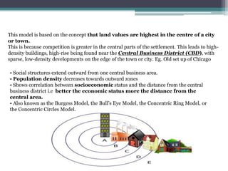
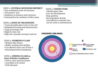
Homer Hoyt proposed the sector model as an update to the concentric zone model. The sector model accounts for major transportation routes radiating out from the central business district. Land uses, such as industrial, commercial, and residential zones, develop along these transportation corridors in wedge-shaped sectors. The model places low-income housing and industry closest to the central business district, with wealthier residential neighborhoods farther out. Examples of cities that generally follow the sector model include Chicago and Calgary.
Concentric Zone Model Theory and Its Limitations. Concentric Zone Model Theory was created by sociologist EW Burgess in 1925. Based on a study of land use patterns and social group in Chicago. City grows outward beginning with the CBD. Similar & functionally related activities will locate at the same distance from CBD.
concentric zone theory paper
concentric zone theory articles
chicago's concentric zone theory
concentric zone model definition
concentric zone theory of crime
concentric zone model example
concentric zone model strengths
concentric zone theory and statistics
The C.B.D or Central Business District is the focal point of a city. It is the commercial, office, retail, and cultural center of the city and usually is the center point for transportation networks.
The multiple nuclei model is an economical model created by Chauncy Harris and Edward Ullman in the 1945 article "The Nature of Cities". The Model. The model describes the layout of a city, based on Chicago. It says that even though a city may have ...
multiple nuclei model example
harris ullman multiple nuclei model
advantages of multiple nuclei model
multiple nuclei model explained
multiple nuclei model example city
los angeles multiple nuclei model
describe the multiple nuclei model of cities
multiple nuclei model strengths
multiple nuclei model example
multiple nuclei model definition
multiple nuclei model example city
multiple nuclei model explained
multiple nuclei model strengths
advantages of multiple nuclei model
nuclei model
multiple nuclei model criticisms
A presentation on "Evolution of town, cities and urban: A world perspective, by Rajendra P Sharma, Social Anthropologist and Planner, Kathmandu, Nepal can be reached at rpsharma@mailcity.com
The sector model, also known as the Hoyt model, is a model of urban land use proposed in 1939 by land economist Homer Hoyt. It is a modification of the concentric zone model of city development. The benefits of the application of this model include the fact it allows for an outward progression of growth.
Impact of renaissance & industrial revolution on city forms & Concepts of utopiaAnoushka Tyagi
The presentation contains principles, and the impacts on city forms with respect to different movements- like the Park movement, linear city concept, Settlement house movement, city beautiful, and the garden city movement.
Review of Mumbai Metropolitan regional development planAnoushka Tyagi
The presentation is a Review of the Mumbai Metropolitan regional development plan with respect to the details of the districts, tehsils, population distribution & density, the content of the regional development plan document, administrative setup in the district, the chronology of earlier plans and the SWOT related to the MMR region.
Appreciation of an Urban Neighbourhood at Dehradun UttarakahndAnoushka Tyagi
The area selected for the study is the area between Prince chowk to Darshan Laal chowk including the Dhamawalla Mohalla & Dalanwala. The Land-use, reasons for site selection, Mapping of physical attributes to understand the exiting planning on the site, urban policies and issues and challenges faced in the urban infrastructure are accessed along with their remedial measures.
The presentation consists of the demographic overview of the blocks and the district of Dehradun, including the population, growth rate, workforce participation, occupation pattern, literacy rate, gender ratio and other statistics.
Case study on the GMCH chandigarh, india
Case study on AIIMS rishikesh, india.
climatic details, grid details, column placement, climatic in influence, site plan, medical college and hospital case study, services
Operation “Blue Star” is the only event in the history of Independent India where the state went into war with its own people. Even after about 40 years it is not clear if it was culmination of states anger over people of the region, a political game of power or start of dictatorial chapter in the democratic setup.
The people of Punjab felt alienated from main stream due to denial of their just demands during a long democratic struggle since independence. As it happen all over the word, it led to militant struggle with great loss of lives of military, police and civilian personnel. Killing of Indira Gandhi and massacre of innocent Sikhs in Delhi and other India cities was also associated with this movement.
How to Create Map Views in the Odoo 17 ERPCeline George
The map views are useful for providing a geographical representation of data. They allow users to visualize and analyze the data in a more intuitive manner.
We all have good and bad thoughts from time to time and situation to situation. We are bombarded daily with spiraling thoughts(both negative and positive) creating all-consuming feel , making us difficult to manage with associated suffering. Good thoughts are like our Mob Signal (Positive thought) amidst noise(negative thought) in the atmosphere. Negative thoughts like noise outweigh positive thoughts. These thoughts often create unwanted confusion, trouble, stress and frustration in our mind as well as chaos in our physical world. Negative thoughts are also known as “distorted thinking”.
Unit 8 - Information and Communication Technology (Paper I).pdfThiyagu K
This slides describes the basic concepts of ICT, basics of Email, Emerging Technology and Digital Initiatives in Education. This presentations aligns with the UGC Paper I syllabus.
This is a presentation by Dada Robert in a Your Skill Boost masterclass organised by the Excellence Foundation for South Sudan (EFSS) on Saturday, the 25th and Sunday, the 26th of May 2024.
He discussed the concept of quality improvement, emphasizing its applicability to various aspects of life, including personal, project, and program improvements. He defined quality as doing the right thing at the right time in the right way to achieve the best possible results and discussed the concept of the "gap" between what we know and what we do, and how this gap represents the areas we need to improve. He explained the scientific approach to quality improvement, which involves systematic performance analysis, testing and learning, and implementing change ideas. He also highlighted the importance of client focus and a team approach to quality improvement.
Palestine last event orientationfvgnh .pptxRaedMohamed3
An EFL lesson about the current events in Palestine. It is intended to be for intermediate students who wish to increase their listening skills through a short lesson in power point.
2. INTRODUCTION
CONCENTRIC ZONE THEOREY
CHICAGO AS CONCENTRIC ZONE THEORY
LIMITATIONS AND CRITICISMS OF CONCENTRIC ZONE MODEL
SECTOR MODEL
COMPONENTS OF SECTOR MODEL
CHICAGO AS SECTOR MODEL
ADVANTAGES OF THE SECTOR MODEL
LIMITATIONS OF SECTOR MODEL
SIMILARITY BETWEEN CONCENTRIC AND SECTOR MODEL
CONTENTS
3. INTRODUCTION
• With time, a number of models have been created based on studies to identify patterns of land use to overcome the
• complexity of land uses found throughout a city. Land use models are theories which attempt to explain the
layout of urban areas.
• The forces underlying the pattern of land use, process of urban growth and accessibility within and
outward of a city can be generalized by means of a number of theories.
The commonly referred models of city structure or theories explaining urban morphology are
✓ CONCENTRIC
✓ SECTORAL
• THE MULTIPLE NUCLEI:
Multiple nuclei model of 1945 by C.D. Harris and Edward L. Ullman is based on the argument that
the cities have multiple growth points or “nuclei” around which growth take place.
SOURCE:
https://pranilblogs.wordpress.com/2016/10/08/sector-model-a-brief-analysis/
https://planningtank.com/settlement-geography/hoyt-model-sector-model-land-use-1939-homer-hoyt
4. CONCENTRIC ZONE THEORY (1925)
Ernest Burgess
• Ernest Burgess gave a model to define how different social groups are located in a
metropolitan area.
• Social groups based on the socio-economic status of households and distance
from central area or downtown. This model is known as the concentric zone model.
EARNEST W BURGESS
• Ernest Watson Burgess (May 16, 1886 – December 27, 1966) was a Canadian-
American urban sociologist born in Tilbury, Ontario.
• Educated at Kingfisher College in Oklahoma and continued
graduate studies in sociology at the University of Chicago.
• In 1916, he returned to the University of Chicago, as a faculty
member. Burgess was hired as an urban sociologist at the
University of Chicago.
• Burgess also served as the 24th President of the American
Sociological Association (ASA).
SOURCE:
https://pranilblogs.wordpress.com/2016/10/08/sector-model-a-brief-analysis/
https://planningtank.com/settlement-geography/hoyt-model-sector-model-land-use-1939-homer-hoyt
5. This model is based on the concept that land values are highest in the centre of a city
or town.
This is because competition is greater in the central parts of the settlement. This leads to high-
density buildings, high-rise being found near the Central Business District (CBD), with
sparse, low-density developments on the edge of the town or city. Eg. Old set up of Chicago
• Social structures extend outward from one central business area.
• Population density decreases towards outward zones
• Shows correlation between socioeconomic status and the distance from the central
business district i.e better the economic status more the distance from the
central area.
• Also known as the Burgess Model, the Bull’s Eye Model, the Concentric Ring Model, or
the Concentric Circles Model.
6. ZONE 1: CENTRAL BUSINESS DISTRICT
• Non-residential center for business.
• “Downtown” area
• Emphasis on business and commerce
• Commuted to by residents of other zones
ZONE 2: ZONE OF TRANSITION
• “Least desirable place to live in the city”
• Dilapidated housing and infrastructure
• Large percentage rent
• Highest crime rate
• High rate of people moving in and out
ZONE 3: WORKING CLASS
• Modest older homes
• Stable, working class families
• Can afford to move out of Zone 2
• Second generation immigrants
ZONE 4: MIDDLE CLASS or
Zone of better residences
• Newer, more spacious homes
• Less likely to be rented
• Well educated
ZONE 5: COMMUTERS
• Mostly upper class
•Low rise development
•large gardens,
•less population density
• Can afford to commute into
city for work or entertainment
7. CHICAGO
•Many of the original and innovative
contributions to the field of urban
sociology came out of the University of
Chicago in the early 20th Century. Two of
the major proponents of urban ecology
were
•Ernest Burgess and
•Robert E. Park,
professors at the University of Chicago,
they proposed a model for the spatial
organization of cities called concentric
zone theory which along with
Hoyt’s sector model and Harris and
Ullman’s multiple nuclei model is
considered a classic model of urban land
use.
•Chicago, a city in the U.S. state of
Illinois, is the third most populous city in
the United States and the most populous
city in the American Midwest with
approximately 2.7 million residents. Its
metropolitan area is very large
CASE STUDY
8. The principle structural regions of Burgess’ Chicago are:
1. Loop (CBD), the business centre and the region of greatest mobility. Hotels are located
here and the residents are primarily transients. This area empties at night and fills in the
morning.
2. Transition zone: occupied by slums. This was the former suburbs of the old city and was
taken over by businesses expanding from the CBD. Apartments here are flats, furnished
rooms and are deteriorated and occupied primarily by childless people.
3. Workingmen’s homes: roomers (on the edge of the slums) where factory workers and
shop workers with families dwell and unsettled young people – the ‘respectable’ working
class.
4. Zone of better residences: apartments, small families and shops. Here the middle
class
residents dwell and this area is served by local subsidiary shopping centres.
5. The commuter’s zone: duplex apartments (houses converted into double flats), single
dwellings, house owners and families.
Further out we can identify two more concentric zones:
6: the agricultural district and zone 7: the hinterland.
9. LIMITATIONS AND CRITICISMS OF CONCENTRIC ZONE MODEL
Concentric zone model is one of the simplest model available. This model accounts for the
economic forces which drive development and the study of patterns present at the time of the
study. But with the evolution and passage of time urban areas grew more complex and this
model cannot define the development of existing cities. Some of the limitations and criticism
include:
•Although widely appreciated in the United States Burgess model is not applicable outside
the US. This is so, as the pattern of growth is different because of various circumstances.
•The relevance of this model decreased over time. With the advancement in the mode of
transportation, mass transit vehicles, motor vehicles, cars changed the way people commute.
Accordingly, their preference for living in a particular zone changed.
•It does not take into account the effect of political forces and the restrictions imposed by
the government for the improvement of living conditions.
•In reality, no distinct zones and boundaries exist as overlapping of areas is possible in
every town. The preference of people changes over time depending on the importance they
associate for a particular benefit.
•This model is not applicable to polycentric cities as many CDB exists in such towns.
Moreover, every city is different, and the factors influencing the growth of a city are diverse.
10. HOYT’S SECTOR MODEL
Homer Hoyt (1895–1984) was a land economist, a real estate
appraiser, and a real estate consultant.
In his long and accomplished life,
•he conducted path-breaking research on land economics,
•developed an influential approach to the analysis of neighborhoods and
housing markets,
•refined local area economic analysis, and
• was a major figure in the development of suburban shopping centers in the
decades after World War II.
•His sector model of land use remains one of his most well-known contributions
to urban scholarship.
• The sector model is an updated version of the concentric zone
model.
•As the city grows, activities within it grow outward in a wedge
shape from the Central Business District (CBD).
•Hoyt modified the concentric zone model to account for major
transportation routes.
•Most major cities evolved around the nexus of several important
transport facilities such as sea ports, railroads, and trolley lines that
radiated from the city’s centre.
•It is a mono centric representation of urban areas.
11. COMPONENTS OF HOYT’S SECTOR MODEL
The Central Business District (CBD)
is the area of the city where retail and office activities are clustered, and is the centre of the city,
economically and geographically.
Low Class Residential
•The low income residential tend to be close to railroad lines, and commercial foundations
along the business areas.
•mainly occupied by the poorer people who usually work in the factories, so they have to live close
to the industry to save transportation costs.
•less desirable for living, due to traffic, noise, and smells and pollution emitted from the
industries,
SOURCE:https://www.livingston.org/cms/lib4/NJ01000562/Centricity/Domain/813/Compare%20and%20Contrast%
20Urban%20Land%20Use%20Models.pdf
12. Industry and Transportation
•The industry sectors are predominantly set up along transportation lines such as water
canals and rail lines.
•provides an income for the low income people of the society and the needs for the
people.
Middle Income Residential
•The middle income residential are further away from manufacturing and industrial sectors
•more desirable to live in than low income residential.
•It joins the CBD for working middle income people for easy access to work.
•These housings have trees and are much more spacious.
High class residential
•The high income residential are the most expensive housing and have the greatest distance from industrial
sectors,
•cleaner environment with less traffic jams, cleaner air and sounds.
13. Chicago today is closer to this model than the original concentric zone model. Calgary in
Canada is also another example of a sector model city.
With the 20th century public transport became
an important part of city planning. Now along
with private vehicles , and also increasing
demography public transport was important to
include in the model. Now places with transport
and accessibility the land value started
increasing . So now roads were planned and the
expansion was along the road and the sectors
such formed took a wedge shape.
Legend-
Loop- CBD
Lakeview centre, lincoln park old town-
Highly populated residential area
Hayde park(green area)- Ports of chiacgo
Uptown- Commercial area, high rise
Image source:http://libertaddeeleccion.org/chicago-l-train-map/chicago-l-train-mapphotographic-gallerychicago-l-
subway/
14. Advantages of the Sector Model:
•It looks at the effect of transport and communication links.
•Numerous cities do seem to have followed this model. If turned 90 degrees anti-clockwise,
the Hoyt model fits the city of Newcastle upon Tyne reasonably accurately.
•Pie shaped wedges made by Hoyt compensated for the drawbacks of the Ring model.
•Though not perfect it takes into account the lines of growth.
•It allows for an outward progression of growth.
Limitations of sector model:
•There is no reference to the physical environment.
•The theory is based on nineteenth century transport and does not make allowances for private
cars which allow commuting from outside city boundaries where land is much cheaper.
•The growth of a sector can be stopped with land use radiating out of the inner city.
•It does not consider the new concepts of edge cities and boom burbs, which came up in
the 1980s, after the creation of the model. Since its creation, the traditional CBD has diminished
in importance as numerous office and retail buildings have moved into the suburbs.
•Like all models of urban form its validity is limited.
SOURCE:
https://www.livingston.org/cms/lib4/NJ01000562/Centricity/Domain/813/Compare%20and%20Contrast%20U
rban%20Land%20Use%20Models.pdf
15. SIMILARITY BETWEEN CONCENTRIC AND SECTOR MODEL:
1) Both models focus on importance of accessibility. The centrally located C.B.D. is
the most accessible and its land value or rent-bid is the highest.
2) Distance decay theory (is a geographical term which describes the effect
of distance on cultural or spatial interactions)The distance decay effect states that the
interaction between two locales declines as the distance between them increases. is
applicable in both models. Land value and population density decline with distance from
the central places.
3) There are clear-cut and abrupt boundaries between the land-use zones.
4) Both concern the study of ground-floor functions instead of the three-dimensional study
as height of buildings is neglected
5) Residential segregation
SOURCE:
https://www.livingston.org/cms/lib4/NJ01000562/Centricity/Domain/813/Compare%20and%20Contrast%20U
rban%20Land%20Use%20Models.pdf
16. CONCENTRIC MODEL:
1) concentric model with circular
pattern of land use zones; while sector
model with sectoral pattern of land use
zones.
2) concentric model never mentioned
the transport development .
3) but concentric model concerns the
invasion, succession forces on the pattern
of the land use.
SECTOR MODEL:
1)while sector model with sectoral
pattern of land use zones
2) land use zones in sector model
developed along transport routes
radiating out from CBD
3) sector model emphasizes the repelling
forces of land uses.
DIFFERENCES BETWEEN CONCENTRIC AND SECTOR MODEL
SOURCE:
https://www.livingston.org/cms/lib4/NJ01000562/Centricity/Domain/813/Compare%20and%20Contrast%20U
rban%20Land%20Use%20Models.pdf