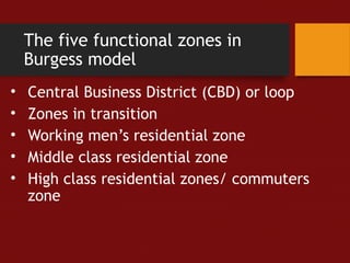
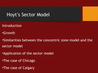
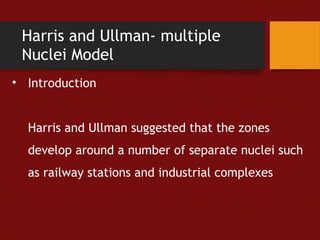
Spatial patterns in urban
landscape
• Definition of Urban Morphology
- Urban morphology refers to the physical
arrangement or structure of towns and
cities. It involves the mapping and
description of patterns of internal land use,
and includes street patterns, individual
buildings ,building blocks, densities and the
different functions of the town or city
Factors Influencing Urban
Morphology
• Site factors
• Historical and cultural factors
• Functional factors
• Government influence
• Social values
• Economic forces
~ economic circulation
~ economic accessibility / urban land rents
Bid Rent Theory
Bid rent theory
The Urban Land Rent Concept
and Distance Decay Mechanism
• 1. Areas of high accessibility
~ Centre of the city
~ Major traffic routes
~ Major traffic intersections
• Land values and uses in a city
~ The central Business district
~ Industrial land use
~ Residential land use
Bid rent
• Bid rent is the value of the land for different
purposes, such as commercial, manufacturing
residential purposes. Land at the centre of a city is
most expensive: it is the most accessible land to
public transport, and there is only a small amount
available.
• Prices decrease away from the central rea, although
there are secondary peaks at the intersections of
main roads and ring roads. Change in levels of
accessibility, due to private transport as opposed to
public transport explains why areas on the edge of
town are often now more accessible than inner areas.
Models of urban structure
Introduction
Most western cities exhibit areal specialization in
their internal land use patterns. That means “
functional areas” or “ functional zones”
The growth of cities in the 19th
century and early 20th
centuries produced a from that was easily
recognizable. It included a commercial area a
surrounding industrial zone with densely packed
housing, and out zones of suburban expansion and
development.
Every model is a simplification. Not evey city will fit
these models perfectly.
Stages of urban growth
• Infantile stage
• Juvenile stage
• Adolescent stage
• Early mature stage
• Fully mature stage
Urban Land Use Models
Burgess:
Concentric Zone
Hoyt:
Sector
Harris, Ullman:
Multiple Nuclei
Burgess’ Concentric Zone Model
1. Burgess’ concentric zone model is an
inductive model based on the case study of
Chicago in the 1920s. It is one of the
earliest attempts to provide some insight
into urban structure
2. Burgess used ecological factors to explain
the spatial variations within the city
Concentric Zone Model
• Competition
• Dominance
• Invasion
• Succession
Implicit assumptions
• The population throughout the city is evenly
distributed
• Movement is equally easy in all directions
• The whole city is considered an isotropic plain and
values decline regularly from a common central
point in the city
• Economic rent is highest near city centre and
decreases progressively away from the core
• Low income families are forced to live in high
density apartments or tenements close to the city
core
The five functional zones in
Burgess model
• Central Business District (CBD) or loop
• Zones in transition
• Working men’s residential zone
• Middle class residential zone
• High class residential zones/ commuters
zone
Advantages of the Burgess
Model
The model has the advantage that it is simple and
comprehensive and significant land uses and their
relationship are pinpointed in a generalized form.
Moreover, since it is an inductive model, taking real
examples from American cities in the 1920s, it represents
a way to interpret the process of city growth during that
particular period for some existing towns and cities
Criticisms of Burgess Model
Critics of the model
Pointed out even though portions of each zone did
exist, rarely were they linked to totally surround the
city
Burgess countered there were distinct barriers, such
as old industrial centers, preventing the completion
of the arc.
Others felt Burgess, as a sociologist, overemphasized
residential patterns and did not give proper credit to
other land uses
Criticisms of Burgess model
• Zonal Boundaries
• Internal heterogeneity of zones
• Outdated model
• Lack of universality
• Distortions
• Building heights
Conclusion
• The zonal model is based on an empirical study
• The model is normative and inductive and is therefore
limited historically and culturally.
• It emphasizes clear cut boundaries which cannot be
justified by gradient study.
• Nevertheless, it remains useful as a first approximation
of urban land use and has stimulated many other studies
Hoyt’s Sector Model
Introduction
•Growth
•Similarities between the concentric zone model and the
sector model
•Application of the sector model
•The case of Chicago
•The case of Calgary
Hoyt’s Sector Model
Criticisms of Hoyt’s model
Hoyt’s model is generally considered to be better
than the burgess model as both the distance and
direction from the city centre are considered
Weakness:
Narrow focus
Height of building
Mixed land use zones
Modern developments
Harris and Ullman- multiple
Nuclei Model
• Introduction
Harris and Ullman suggested that the zones
develop around a number of separate nuclei such
as railway stations and industrial complexes
Multiple Nuclei
Zones in the multiple nuclei
model
• Specialized requirement of certain activities
• Grouping of similar activities
• Repulsion of some activities by others
• Ability of activities to pay rents and rates
Advantages of the multiple nuclei
model
• Improved transportation
• Hierarchical order of land use
• Functional zones
• Agglomeration
• Suburbanization and decentralization
• Accommodation of irregularities
• Time dimension
• Flexibility
Criticism of the multiple nuclei
model
• Height of the building
• Rigidity
Delimiting the CBD
Central Business Index
The Central Business Height Index(CBHI)
CBHI= total floor area of all CBD functions/
total ground floor area
The Central Business Intensity Index (CBII)
CBII= total floor area of all CBD functions *100%
/ Total floor area
The Central Business Index
CBI= CBHI of 1+ CBII OF 50%
Urban Population Densities
1. Distribution of population density within a
city
2. Change over time in a density-decay curves
Residential Mobility
Factors responsible for responsible for residential mobility
•Improved living environment
•Establishment of a new family
•Land rent mechanism and land supply
•Job or employment opportunities
•Improved communications
•Government policy
Residential mobility in Hong Kong
• forced moves
• voluntary moves
The morphology of Asian Cities
Distinct city types in Asia
•The indigenous city
•Centres of western penetration
•The colonial city
Problems of Urbanisation
Problems in foreign countries
Primate Cities: a large city 2ce as large as the next largest
city, usually with a large proportion of the national city
population, e.g. Mexico City, Lagos (Nigeria), Bangkok
(Thailand), Paris (France), London (England), etc.
Cities usually become ‘primate’ (large) because too much
attention is given to that particular city at the expense of
others. Therefore it grows at the expense of other towns, and
ends up drawing more immigrants from the countryside who
are looking for work. This then leads to problems shown on
next slide, especially in developing countries.

Urban models

  • 1.
    Spatial patterns inurban landscape • Definition of Urban Morphology - Urban morphology refers to the physical arrangement or structure of towns and cities. It involves the mapping and description of patterns of internal land use, and includes street patterns, individual buildings ,building blocks, densities and the different functions of the town or city
  • 3.
    Factors Influencing Urban Morphology •Site factors • Historical and cultural factors • Functional factors • Government influence • Social values • Economic forces ~ economic circulation ~ economic accessibility / urban land rents
  • 4.
  • 5.
  • 6.
    The Urban LandRent Concept and Distance Decay Mechanism • 1. Areas of high accessibility ~ Centre of the city ~ Major traffic routes ~ Major traffic intersections • Land values and uses in a city ~ The central Business district ~ Industrial land use ~ Residential land use
  • 7.
    Bid rent • Bidrent is the value of the land for different purposes, such as commercial, manufacturing residential purposes. Land at the centre of a city is most expensive: it is the most accessible land to public transport, and there is only a small amount available. • Prices decrease away from the central rea, although there are secondary peaks at the intersections of main roads and ring roads. Change in levels of accessibility, due to private transport as opposed to public transport explains why areas on the edge of town are often now more accessible than inner areas.
  • 8.
    Models of urbanstructure Introduction Most western cities exhibit areal specialization in their internal land use patterns. That means “ functional areas” or “ functional zones” The growth of cities in the 19th century and early 20th centuries produced a from that was easily recognizable. It included a commercial area a surrounding industrial zone with densely packed housing, and out zones of suburban expansion and development. Every model is a simplification. Not evey city will fit these models perfectly.
  • 9.
    Stages of urbangrowth • Infantile stage • Juvenile stage • Adolescent stage • Early mature stage • Fully mature stage
  • 10.
    Urban Land UseModels Burgess: Concentric Zone Hoyt: Sector Harris, Ullman: Multiple Nuclei
  • 11.
    Burgess’ Concentric ZoneModel 1. Burgess’ concentric zone model is an inductive model based on the case study of Chicago in the 1920s. It is one of the earliest attempts to provide some insight into urban structure 2. Burgess used ecological factors to explain the spatial variations within the city
  • 12.
  • 13.
    • Competition • Dominance •Invasion • Succession
  • 14.
    Implicit assumptions • Thepopulation throughout the city is evenly distributed • Movement is equally easy in all directions • The whole city is considered an isotropic plain and values decline regularly from a common central point in the city • Economic rent is highest near city centre and decreases progressively away from the core • Low income families are forced to live in high density apartments or tenements close to the city core
  • 15.
    The five functionalzones in Burgess model • Central Business District (CBD) or loop • Zones in transition • Working men’s residential zone • Middle class residential zone • High class residential zones/ commuters zone
  • 16.
    Advantages of theBurgess Model The model has the advantage that it is simple and comprehensive and significant land uses and their relationship are pinpointed in a generalized form. Moreover, since it is an inductive model, taking real examples from American cities in the 1920s, it represents a way to interpret the process of city growth during that particular period for some existing towns and cities
  • 17.
    Criticisms of BurgessModel Critics of the model Pointed out even though portions of each zone did exist, rarely were they linked to totally surround the city Burgess countered there were distinct barriers, such as old industrial centers, preventing the completion of the arc. Others felt Burgess, as a sociologist, overemphasized residential patterns and did not give proper credit to other land uses
  • 18.
    Criticisms of Burgessmodel • Zonal Boundaries • Internal heterogeneity of zones • Outdated model • Lack of universality • Distortions • Building heights
  • 19.
    Conclusion • The zonalmodel is based on an empirical study • The model is normative and inductive and is therefore limited historically and culturally. • It emphasizes clear cut boundaries which cannot be justified by gradient study. • Nevertheless, it remains useful as a first approximation of urban land use and has stimulated many other studies
  • 20.
    Hoyt’s Sector Model Introduction •Growth •Similaritiesbetween the concentric zone model and the sector model •Application of the sector model •The case of Chicago •The case of Calgary
  • 21.
  • 22.
    Criticisms of Hoyt’smodel Hoyt’s model is generally considered to be better than the burgess model as both the distance and direction from the city centre are considered Weakness: Narrow focus Height of building Mixed land use zones Modern developments
  • 23.
    Harris and Ullman-multiple Nuclei Model • Introduction Harris and Ullman suggested that the zones develop around a number of separate nuclei such as railway stations and industrial complexes
  • 24.
  • 25.
    Zones in themultiple nuclei model • Specialized requirement of certain activities • Grouping of similar activities • Repulsion of some activities by others • Ability of activities to pay rents and rates
  • 26.
    Advantages of themultiple nuclei model • Improved transportation • Hierarchical order of land use • Functional zones • Agglomeration • Suburbanization and decentralization • Accommodation of irregularities • Time dimension • Flexibility
  • 27.
    Criticism of themultiple nuclei model • Height of the building • Rigidity
  • 28.
    Delimiting the CBD CentralBusiness Index The Central Business Height Index(CBHI) CBHI= total floor area of all CBD functions/ total ground floor area The Central Business Intensity Index (CBII) CBII= total floor area of all CBD functions *100% / Total floor area
  • 29.
    The Central BusinessIndex CBI= CBHI of 1+ CBII OF 50%
  • 30.
    Urban Population Densities 1.Distribution of population density within a city 2. Change over time in a density-decay curves
  • 31.
    Residential Mobility Factors responsiblefor responsible for residential mobility •Improved living environment •Establishment of a new family •Land rent mechanism and land supply •Job or employment opportunities •Improved communications •Government policy
  • 32.
    Residential mobility inHong Kong • forced moves • voluntary moves
  • 33.
    The morphology ofAsian Cities Distinct city types in Asia •The indigenous city •Centres of western penetration •The colonial city
  • 34.
    Problems of Urbanisation Problemsin foreign countries Primate Cities: a large city 2ce as large as the next largest city, usually with a large proportion of the national city population, e.g. Mexico City, Lagos (Nigeria), Bangkok (Thailand), Paris (France), London (England), etc. Cities usually become ‘primate’ (large) because too much attention is given to that particular city at the expense of others. Therefore it grows at the expense of other towns, and ends up drawing more immigrants from the countryside who are looking for work. This then leads to problems shown on next slide, especially in developing countries.