Downloaded 445 times


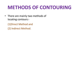
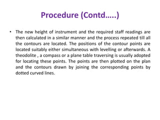
![1] Direct Method:
• In this method, the contours to be
located are directly traced out in
the field by locating and marking a
number of points on each contour.
These points are then surveyed
and plotted on plan and the
contours drawn through them.
• This method is most accurate but
very slow and tedious as a lot of
time is wasted in searching points
of the same elevation for a
contour.
• This is suitable for small area and
where great accuracy is required
50
48
B.M.
DIRECT METHOD OF
CONTOURING](https://image.slidesharecdn.com/anandcontour-150823092823-lva1-app6891/85/surveying-contouring-7-320.jpg)


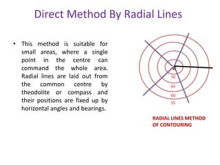
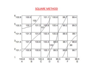
![• This method is commonly employed in all kinds of surveys as this is
cheaper, quicker and less tedious as compared to direct method.
There are mainly three method of contouring in indirect method:
• (I) BY SQUARES [SQUARE METHOD]:- In this method, the whole
area is divided into number of squares, the side of which may vary
from 5m to 30m depending upon the nature of the ground and the
contour interval. The square need not be of the same size
throughout.
• The corners of the squares are pegged out and the reduced levels
of these points are determined with a level.](https://image.slidesharecdn.com/anandcontour-150823092823-lva1-app6891/85/surveying-contouring-14-320.jpg)


Contour lines on a map connect points of equal elevation above sea level. They show the shape and features of the land. There are two main methods for creating contour maps - direct and indirect. The direct method precisely traces contours in the field but is slow. The indirect method takes spot elevations across an area and interpolates the contour lines, making it faster but less precise. Common indirect techniques include surveying on a grid, along cross-sections, or using a tacheometer along radial lines. Contour maps provide topographic information for engineering projects.


