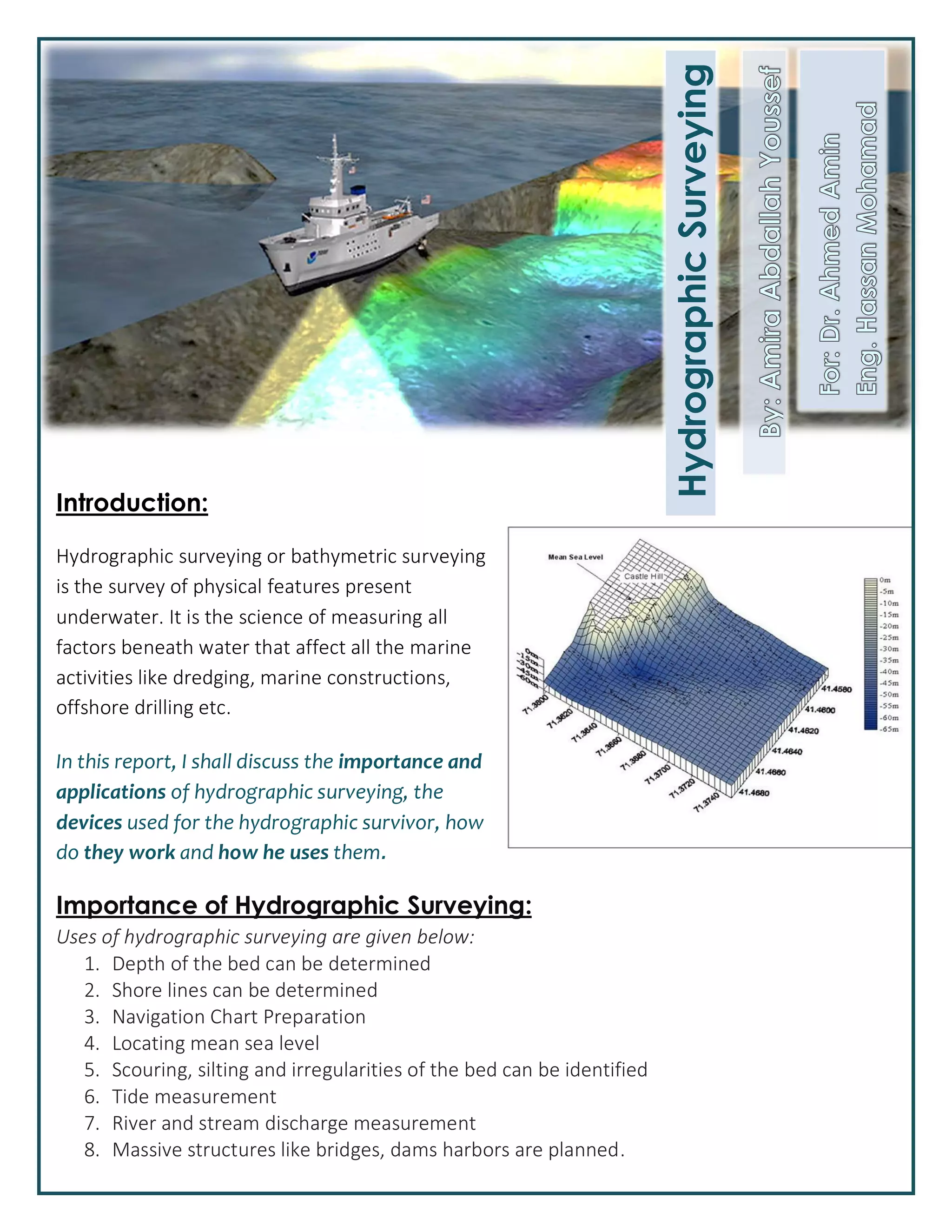
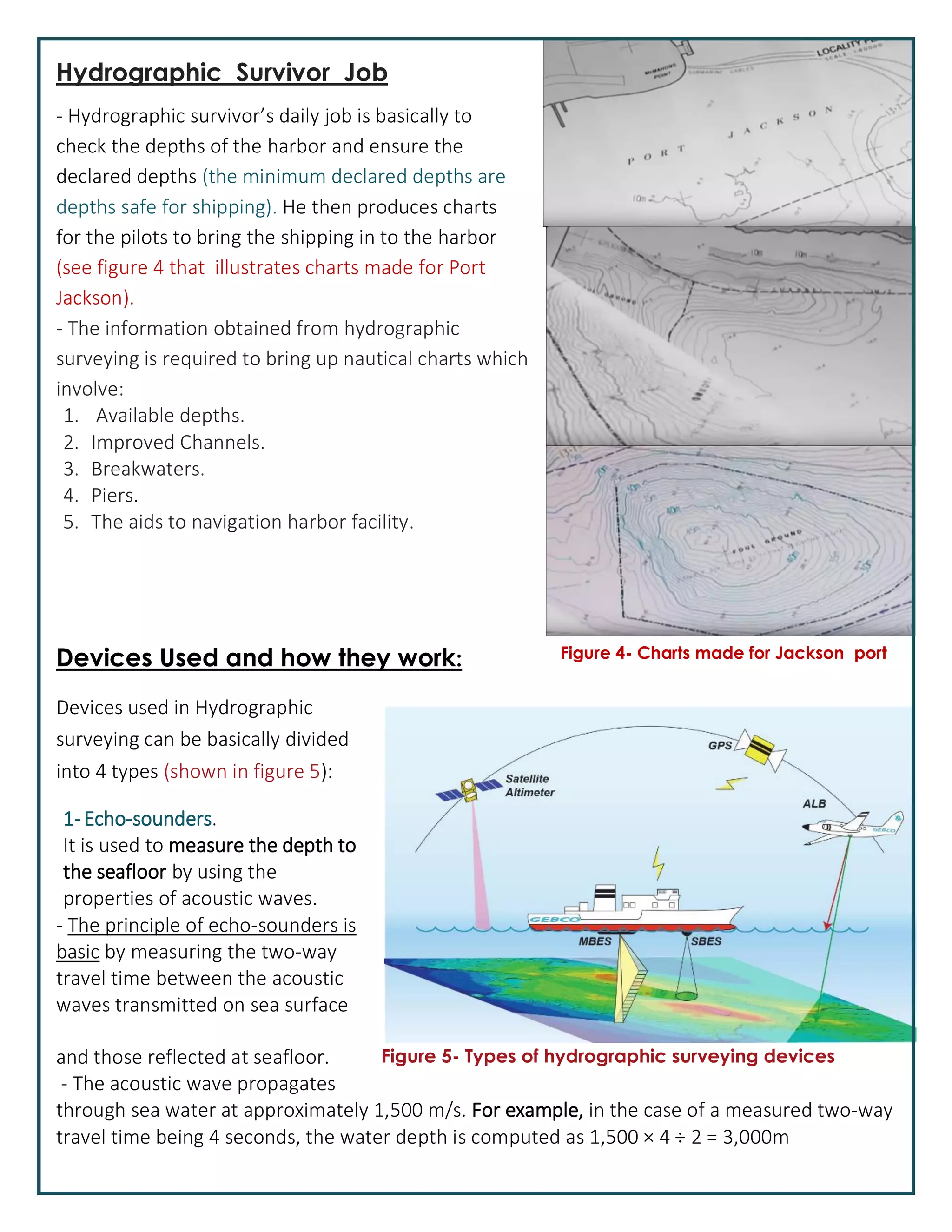
SlideShare a Scribd company logo
1 of 5
Download to read offline
Introduction:
Hydrographic surveying or bathymetric surveying
is the survey of physical features present
underwater. It is the science of measuring all
factors beneath water that affect all the marine
activities like dredging, marine constructions,
offshore drilling etc.
In this report, I shall discuss the importance and
applications of hydrographic surveying, the
devices used for the hydrographic survivor, how
do they work and how he uses them.
Importance of Hydrographic Surveying:
Uses of hydrographic surveying are given below:
1. Depth of the bed can be determined
2. Shore lines can be determined
3. Navigation Chart Preparation
4. Locating mean sea level
5. Scouring, silting and irregularities of the bed can be identified
6. Tide measurement
7. River and stream discharge measurement
8. Massive structures like bridges, dams harbors are planned.
HydrographicSurveying
The applications of hydrographic surveying:
1. Dock and Harbor Engineering
2. Irrigation
3. River Works
4. Land reclamation
5. Water Power
6. Flood Control
7. Sewage Disposal
Methods of Hydrographic Surveying over History:
Lead lines, sounding poles, and single-beam echosounders methods1. (figure 1)
2. Wire-drag surveying. (figure 2)
3. Modern Surveying (which is discussed in this report – )figure 3
Figure 1- old method Figure 2 - Wire drag method
Figure 3 - Modern method
Hydrographic Survivor Job
- Hydrographic survivor’s daily job is basically to
check the depths of the harbor and ensure the
declared depths (the minimum declared depths are
He then produces chartsdepths safe for shipping).
for the pilots to bring the shipping in to the harbor
(see figure 4 that illustrates charts made for Port
Jackson).
- The information obtained from hydrographic
surveying is required to bring up nautical charts which
involve:
1. Available depths.
2. Improved Channels.
3. Breakwaters.
4. Piers.
5. The aids to navigation harbor facility.
Devices Used and how they work:
Devices used in Hydrographic
surveying can be basically divided
into 4 types ):(shown in figure 5
.1-Echo-sounders
It is used to measure the depth to
the seafloor by using the
properties of acoustic waves.
- The principle of echo-sounders is
basic by measuring the two-way
travel time between the acoustic
waves transmitted on sea surface
and those reflected at seafloor.
- The acoustic wave propagates
through sea water at approximately 1,500 m/s. For example, in the case of a measured two-way
travel time being 4 seconds, the water depth is computed as 1,500 Ă— 4 Ă· 2 = 3,000m
Figure 4- Charts made for Jackson port
Figure 5- Types of hydrographic surveying devices
Echo-sounders are
classified into two types,
Single-beam Echosounder
(SBES) which can measure
only one point per
acoustic echo wave (echo)
emitted and Multibeam
Echosounder (MBES)
which is capable of
measuring many points of depth over a wide swath area at the same time.
which estimate information about ocean bathymetry.2- Satellite Altimetry
- The principle of the satellite-altimetry bathymetry is to accurately measure
the distance between the satellite and sea-surface height, where this sea-
surface height is argued to approximately represent the geoid surface. If the
height of the satellite is known in the geocentric coordinate system, then
the sea-surface height, which is the distance between earth ellipsoid and sea
surface, can be computed.
to measure water depth by aircraft equipped with laser3- Airborne Lidar bathymetry (ALB)
ranging system instead of survey vessel with systems that produce acoustic waves.
The ALB principle is to generally transmit two types of lasers, a green laser-
and an infrared laser. The green laser can measure the distance between the
aircraft and the sea bottom, while the infrared laser, which is absorbed by
water, measures the distance between the aircraft and sea surface.
- The merits of ALB is that they are quick and safer surveys in shallow-water
areas, when compared with surveying by vessels. Shallow-water areas
measured using traditional echo-sounder methods take much longer,
because the shallower the water, the smaller the ensonified area becomes
and as a result it takes a long time to survey.
4- Global Positioning System (GPS)
The principle behind GPS positioning is similar to that of radio navigation.
- GPS satellites are equipped with very accurate clocks and the signal
transmitter, and GPS receivers on ship can receive the signal transmitted
from GPS satellites.
The distance between a GPS satellite and a receiver can be determine by-
timing the difference between transmitted and receive times.
The receiver position can also be determined by computing the geometric-
relation among the multiple GPS satellites and the receiver at the same
time.
Hydrographic Surveying

More Related Content

What's hot

CE203 -Hydrographic survey.pptx
CE203 -Hydrographic survey.pptxCE203 -Hydrographic survey.pptx
CE203 -Hydrographic survey.pptxAbdulQHannan
 
Hydrography Midterm Reviewer
Hydrography Midterm ReviewerHydrography Midterm Reviewer
Hydrography Midterm Reviewersorbi
 
Total station
Total stationTotal station
Total stationabhi08121994
 
Triangulation and Trilateration
Triangulation and TrilaterationTriangulation and Trilateration
Triangulation and TrilaterationPramesh Hada
 
Electronic distance measurement (EDM)
Electronic distance measurement (EDM)Electronic distance measurement (EDM)
Electronic distance measurement (EDM)Bathla Tuition Centre
 
Total station
Total station Total station
Total station Shanmugaraj M
 
3.2 Sounding methods.pptx
3.2 Sounding methods.pptx3.2 Sounding methods.pptx
3.2 Sounding methods.pptxYogeshwaranV4
 
Total Station surveying
Total Station surveyingTotal Station surveying
Total Station surveyingRAMPRASAD KUMAWAT
 
Reconnaissance for Hydrographic Survey Project
Reconnaissance for Hydrographic  Survey ProjectReconnaissance for Hydrographic  Survey Project
Reconnaissance for Hydrographic Survey ProjectNzar Braim
 
surveying.ppt
surveying.pptsurveying.ppt
surveying.pptUjasPandya1
 
Tacheometric surveying
Tacheometric surveying Tacheometric surveying
Tacheometric surveying Krish Bhavsar
 
Triangulation survey
Triangulation surveyTriangulation survey
Triangulation surveyHastarajPandey
 
Tacheometry ppt
Tacheometry pptTacheometry ppt
Tacheometry pptVilas Nikam
 
Total station Surveying
Total station SurveyingTotal station Surveying
Total station SurveyingKiran M
 
9. MORDAN SURVEYING INSTRUMENTS (SUR) 3140601 GTU
9. MORDAN SURVEYING INSTRUMENTS (SUR) 3140601 GTU9. MORDAN SURVEYING INSTRUMENTS (SUR) 3140601 GTU
9. MORDAN SURVEYING INSTRUMENTS (SUR) 3140601 GTUVATSAL PATEL
 

What's hot (20)

CE203 -Hydrographic survey.pptx
CE203 -Hydrographic survey.pptxCE203 -Hydrographic survey.pptx
CE203 -Hydrographic survey.pptx
 
Hydrography Midterm Reviewer
Hydrography Midterm ReviewerHydrography Midterm Reviewer
Hydrography Midterm Reviewer
 
Total station
Total stationTotal station
Total station
 
Triangulation and Trilateration
Triangulation and TrilaterationTriangulation and Trilateration
Triangulation and Trilateration
 
Electronic distance measurement (EDM)
Electronic distance measurement (EDM)Electronic distance measurement (EDM)
Electronic distance measurement (EDM)
 
Total station
Total station Total station
Total station
 
3.2 Sounding methods.pptx
3.2 Sounding methods.pptx3.2 Sounding methods.pptx
3.2 Sounding methods.pptx
 
Total Station surveying
Total Station surveyingTotal Station surveying
Total Station surveying
 
Reconnaissance for Hydrographic Survey Project
Reconnaissance for Hydrographic  Survey ProjectReconnaissance for Hydrographic  Survey Project
Reconnaissance for Hydrographic Survey Project
 
surveying.ppt
surveying.pptsurveying.ppt
surveying.ppt
 
Tacheometric surveying
Tacheometric surveying Tacheometric surveying
Tacheometric surveying
 
Triangulation survey
Triangulation surveyTriangulation survey
Triangulation survey
 
Topographical Survey
Topographical SurveyTopographical Survey
Topographical Survey
 
Total station
Total stationTotal station
Total station
 
Control surveying
Control surveyingControl surveying
Control surveying
 
Tacheometry ppt
Tacheometry pptTacheometry ppt
Tacheometry ppt
 
Total station
Total stationTotal station
Total station
 
multibeam
multibeammultibeam
multibeam
 
Total station Surveying
Total station SurveyingTotal station Surveying
Total station Surveying
 
9. MORDAN SURVEYING INSTRUMENTS (SUR) 3140601 GTU
9. MORDAN SURVEYING INSTRUMENTS (SUR) 3140601 GTU9. MORDAN SURVEYING INSTRUMENTS (SUR) 3140601 GTU
9. MORDAN SURVEYING INSTRUMENTS (SUR) 3140601 GTU
 

Similar to Hydrographic Surveying

4- Hydrographic Surveying.pdf
4- Hydrographic Surveying.pdf4- Hydrographic Surveying.pdf
4- Hydrographic Surveying.pdffankarworld
 
Hydrography is the branch of applied science which deals with the measurement...
Hydrography is the branch of applied science which deals with the measurement...Hydrography is the branch of applied science which deals with the measurement...
Hydrography is the branch of applied science which deals with the measurement...Hafez Ahmad
 
Coastal processes wave measurements usage of buoys
Coastal processes wave measurements usage of buoysCoastal processes wave measurements usage of buoys
Coastal processes wave measurements usage of buoysSoumyaranjan Jena
 
Underwater imaging
Underwater imagingUnderwater imaging
Underwater imagingAndrewJBaker
 
Beneath the Surface: Navigating the Depths with Hydrographic Surveys
Beneath the Surface: Navigating the Depths with Hydrographic SurveysBeneath the Surface: Navigating the Depths with Hydrographic Surveys
Beneath the Surface: Navigating the Depths with Hydrographic Surveysfalconsurveyme
 
Hydrography :Sounding Instrument
Hydrography :Sounding InstrumentHydrography :Sounding Instrument
Hydrography :Sounding Instrumentpmevada
 
Hydrography : Tools & Techniques
Hydrography : Tools & TechniquesHydrography : Tools & Techniques
Hydrography : Tools & TechniquesAbdul Alim Kamran
 
Methods of Shore Observations for Horizontal position Fixing
Methods of Shore Observations for Horizontal position FixingMethods of Shore Observations for Horizontal position Fixing
Methods of Shore Observations for Horizontal position FixingNzar Braim
 
W7b Side Scan Sonar 2018-19.pdf
W7b  Side Scan Sonar 2018-19.pdfW7b  Side Scan Sonar 2018-19.pdf
W7b Side Scan Sonar 2018-19.pdfAzryHafize
 
C OMPREHENSIVE S TUDY OF A COUSTIC C HANNEL M ODELS FOR U NDERWATER W I...
C OMPREHENSIVE  S TUDY OF  A COUSTIC  C HANNEL  M ODELS FOR  U NDERWATER  W I...C OMPREHENSIVE  S TUDY OF  A COUSTIC  C HANNEL  M ODELS FOR  U NDERWATER  W I...
C OMPREHENSIVE S TUDY OF A COUSTIC C HANNEL M ODELS FOR U NDERWATER W I...IJCI JOURNAL
 
Hydrographic survey.pptx
Hydrographic survey.pptxHydrographic survey.pptx
Hydrographic survey.pptxPrabinShrestha97
 
sonar
sonarsonar
sonarjhcid
 
Remote sensing
Remote sensingRemote sensing
Remote sensingGomathi Gomu
 
The Nippon foundation -GEBCO seabed 2030
The Nippon foundation -GEBCO seabed 2030The Nippon foundation -GEBCO seabed 2030
The Nippon foundation -GEBCO seabed 2030Abdul Saleem K
 
SEISMIC METHOD
SEISMIC METHODSEISMIC METHOD
SEISMIC METHODShah Naseer
 
Hydrographic Surveying1.pptx
Hydrographic Surveying1.pptxHydrographic Surveying1.pptx
Hydrographic Surveying1.pptxDr. Prasit Agnihotri
 
Surveying II - Hydrographic surveying Unit -5
Surveying II - Hydrographic surveying Unit -5Surveying II - Hydrographic surveying Unit -5
Surveying II - Hydrographic surveying Unit -5JaganNathan555342
 
Ship Speed Estimation using Wireless Sensor Networks: Three and Five Sensors ...
Ship Speed Estimation using Wireless Sensor Networks: Three and Five Sensors ...Ship Speed Estimation using Wireless Sensor Networks: Three and Five Sensors ...
Ship Speed Estimation using Wireless Sensor Networks: Three and Five Sensors ...TELKOMNIKA JOURNAL
 
Archaeological and groundwater investigations
Archaeological and groundwater investigationsArchaeological and groundwater investigations
Archaeological and groundwater investigationsZaidoon Taha
 
Bathymetric Lidar and its uses.pdf
Bathymetric Lidar and its uses.pdfBathymetric Lidar and its uses.pdf
Bathymetric Lidar and its uses.pdfDidoGraphic
 

Similar to Hydrographic Surveying (20)

4- Hydrographic Surveying.pdf
4- Hydrographic Surveying.pdf4- Hydrographic Surveying.pdf
4- Hydrographic Surveying.pdf
 
Hydrography is the branch of applied science which deals with the measurement...
Hydrography is the branch of applied science which deals with the measurement...Hydrography is the branch of applied science which deals with the measurement...
Hydrography is the branch of applied science which deals with the measurement...
 
Coastal processes wave measurements usage of buoys
Coastal processes wave measurements usage of buoysCoastal processes wave measurements usage of buoys
Coastal processes wave measurements usage of buoys
 
Underwater imaging
Underwater imagingUnderwater imaging
Underwater imaging
 
Beneath the Surface: Navigating the Depths with Hydrographic Surveys
Beneath the Surface: Navigating the Depths with Hydrographic SurveysBeneath the Surface: Navigating the Depths with Hydrographic Surveys
Beneath the Surface: Navigating the Depths with Hydrographic Surveys
 
Hydrography :Sounding Instrument
Hydrography :Sounding InstrumentHydrography :Sounding Instrument
Hydrography :Sounding Instrument
 
Hydrography : Tools & Techniques
Hydrography : Tools & TechniquesHydrography : Tools & Techniques
Hydrography : Tools & Techniques
 
Methods of Shore Observations for Horizontal position Fixing
Methods of Shore Observations for Horizontal position FixingMethods of Shore Observations for Horizontal position Fixing
Methods of Shore Observations for Horizontal position Fixing
 
W7b Side Scan Sonar 2018-19.pdf
W7b  Side Scan Sonar 2018-19.pdfW7b  Side Scan Sonar 2018-19.pdf
W7b Side Scan Sonar 2018-19.pdf
 
C OMPREHENSIVE S TUDY OF A COUSTIC C HANNEL M ODELS FOR U NDERWATER W I...
C OMPREHENSIVE  S TUDY OF  A COUSTIC  C HANNEL  M ODELS FOR  U NDERWATER  W I...C OMPREHENSIVE  S TUDY OF  A COUSTIC  C HANNEL  M ODELS FOR  U NDERWATER  W I...
C OMPREHENSIVE S TUDY OF A COUSTIC C HANNEL M ODELS FOR U NDERWATER W I...
 
Hydrographic survey.pptx
Hydrographic survey.pptxHydrographic survey.pptx
Hydrographic survey.pptx
 
sonar
sonarsonar
sonar
 
Remote sensing
Remote sensingRemote sensing
Remote sensing
 
The Nippon foundation -GEBCO seabed 2030
The Nippon foundation -GEBCO seabed 2030The Nippon foundation -GEBCO seabed 2030
The Nippon foundation -GEBCO seabed 2030
 
SEISMIC METHOD
SEISMIC METHODSEISMIC METHOD
SEISMIC METHOD
 
Hydrographic Surveying1.pptx
Hydrographic Surveying1.pptxHydrographic Surveying1.pptx
Hydrographic Surveying1.pptx
 
Surveying II - Hydrographic surveying Unit -5
Surveying II - Hydrographic surveying Unit -5Surveying II - Hydrographic surveying Unit -5
Surveying II - Hydrographic surveying Unit -5
 
Ship Speed Estimation using Wireless Sensor Networks: Three and Five Sensors ...
Ship Speed Estimation using Wireless Sensor Networks: Three and Five Sensors ...Ship Speed Estimation using Wireless Sensor Networks: Three and Five Sensors ...
Ship Speed Estimation using Wireless Sensor Networks: Three and Five Sensors ...
 
Archaeological and groundwater investigations
Archaeological and groundwater investigationsArchaeological and groundwater investigations
Archaeological and groundwater investigations
 
Bathymetric Lidar and its uses.pdf
Bathymetric Lidar and its uses.pdfBathymetric Lidar and its uses.pdf
Bathymetric Lidar and its uses.pdf
 

More from Amira Abdallah

Plasco Building Collapse by fire
Plasco Building Collapse by firePlasco Building Collapse by fire
Plasco Building Collapse by fireAmira Abdallah
 
The dome of the rock (Qubbat Al-sakhra) structural system and load transfer
The dome of the rock (Qubbat Al-sakhra) structural system and load transferThe dome of the rock (Qubbat Al-sakhra) structural system and load transfer
The dome of the rock (Qubbat Al-sakhra) structural system and load transferAmira Abdallah
 
Natural rocks in Civil engineering
Natural rocks in Civil engineeringNatural rocks in Civil engineering
Natural rocks in Civil engineeringAmira Abdallah
 
Methods of population studies
Methods of population studiesMethods of population studies
Methods of population studiesAmira Abdallah
 
Centrifugal & Reciprocating Pumps
Centrifugal & Reciprocating Pumps Centrifugal & Reciprocating Pumps
Centrifugal & Reciprocating Pumps Amira Abdallah
 
Photogrammetry & Remote Sensing applications in Engineering
Photogrammetry & Remote Sensing applications in EngineeringPhotogrammetry & Remote Sensing applications in Engineering
Photogrammetry & Remote Sensing applications in EngineeringAmira Abdallah
 
Paintings (Exterior & Interior) and wall papers
Paintings (Exterior & Interior) and wall papersPaintings (Exterior & Interior) and wall papers
Paintings (Exterior & Interior) and wall papersAmira Abdallah
 
Geology - clay minerals and geotechnical problems
Geology - clay minerals and geotechnical problemsGeology - clay minerals and geotechnical problems
Geology - clay minerals and geotechnical problemsAmira Abdallah
 
Permeability and durability of concrete
Permeability and durability of concretePermeability and durability of concrete
Permeability and durability of concreteAmira Abdallah
 

More from Amira Abdallah (9)

Plasco Building Collapse by fire
Plasco Building Collapse by firePlasco Building Collapse by fire
Plasco Building Collapse by fire
 
The dome of the rock (Qubbat Al-sakhra) structural system and load transfer
The dome of the rock (Qubbat Al-sakhra) structural system and load transferThe dome of the rock (Qubbat Al-sakhra) structural system and load transfer
The dome of the rock (Qubbat Al-sakhra) structural system and load transfer
 
Natural rocks in Civil engineering
Natural rocks in Civil engineeringNatural rocks in Civil engineering
Natural rocks in Civil engineering
 
Methods of population studies
Methods of population studiesMethods of population studies
Methods of population studies
 
Centrifugal & Reciprocating Pumps
Centrifugal & Reciprocating Pumps Centrifugal & Reciprocating Pumps
Centrifugal & Reciprocating Pumps
 
Photogrammetry & Remote Sensing applications in Engineering
Photogrammetry & Remote Sensing applications in EngineeringPhotogrammetry & Remote Sensing applications in Engineering
Photogrammetry & Remote Sensing applications in Engineering
 
Paintings (Exterior & Interior) and wall papers
Paintings (Exterior & Interior) and wall papersPaintings (Exterior & Interior) and wall papers
Paintings (Exterior & Interior) and wall papers
 
Geology - clay minerals and geotechnical problems
Geology - clay minerals and geotechnical problemsGeology - clay minerals and geotechnical problems
Geology - clay minerals and geotechnical problems
 
Permeability and durability of concrete
Permeability and durability of concretePermeability and durability of concrete
Permeability and durability of concrete
 

Recently uploaded

Internship report on mechanical engineering
Internship report on mechanical engineeringInternship report on mechanical engineering
Internship report on mechanical engineeringmalavadedarshan25
 
VICTOR MAESTRE RAMIREZ - Planetary Defender on NASA's Double Asteroid Redirec...
VICTOR MAESTRE RAMIREZ - Planetary Defender on NASA's Double Asteroid Redirec...VICTOR MAESTRE RAMIREZ - Planetary Defender on NASA's Double Asteroid Redirec...
VICTOR MAESTRE RAMIREZ - Planetary Defender on NASA's Double Asteroid Redirec...VICTOR MAESTRE RAMIREZ
 
Application of Residue Theorem to evaluate real integrations.pptx
Application of Residue Theorem to evaluate real integrations.pptxApplication of Residue Theorem to evaluate real integrations.pptx
Application of Residue Theorem to evaluate real integrations.pptx959SahilShah
 
Software and Systems Engineering Standards: Verification and Validation of Sy...
Software and Systems Engineering Standards: Verification and Validation of Sy...Software and Systems Engineering Standards: Verification and Validation of Sy...
Software and Systems Engineering Standards: Verification and Validation of Sy...VICTOR MAESTRE RAMIREZ
 
Study on Air-Water & Water-Water Heat Exchange in a Finned Tube Exchanger
Study on Air-Water & Water-Water Heat Exchange in a Finned Tube ExchangerStudy on Air-Water & Water-Water Heat Exchange in a Finned Tube Exchanger
Study on Air-Water & Water-Water Heat Exchange in a Finned Tube ExchangerAnamika Sarkar
 
IVE Industry Focused Event - Defence Sector 2024
IVE Industry Focused Event - Defence Sector 2024IVE Industry Focused Event - Defence Sector 2024
IVE Industry Focused Event - Defence Sector 2024Mark Billinghurst
 
Architect Hassan Khalil Portfolio for 2024
Architect Hassan Khalil Portfolio for 2024Architect Hassan Khalil Portfolio for 2024
Architect Hassan Khalil Portfolio for 2024hassan khalil
 
INFLUENCE OF NANOSILICA ON THE PROPERTIES OF CONCRETE
INFLUENCE OF NANOSILICA ON THE PROPERTIES OF CONCRETEINFLUENCE OF NANOSILICA ON THE PROPERTIES OF CONCRETE
INFLUENCE OF NANOSILICA ON THE PROPERTIES OF CONCRETEroselinkalist12
 
Decoding Kotlin - Your guide to solving the mysterious in Kotlin.pptx
Decoding Kotlin - Your guide to solving the mysterious in Kotlin.pptxDecoding Kotlin - Your guide to solving the mysterious in Kotlin.pptx
Decoding Kotlin - Your guide to solving the mysterious in Kotlin.pptxJoĂŁo Esperancinha
 
Heart Disease Prediction using machine learning.pptx
Heart Disease Prediction using machine learning.pptxHeart Disease Prediction using machine learning.pptx
Heart Disease Prediction using machine learning.pptxPoojaBan
 
Gurgaon ✡️9711147426✨Call In girls Gurgaon Sector 51 escort service
Gurgaon ✡️9711147426✨Call In girls Gurgaon Sector 51 escort serviceGurgaon ✡️9711147426✨Call In girls Gurgaon Sector 51 escort service
Gurgaon ✡️9711147426✨Call In girls Gurgaon Sector 51 escort servicejennyeacort
 
Gfe Mayur Vihar Call Girls Service WhatsApp -> 9999965857 Available 24x7 ^ De...
Gfe Mayur Vihar Call Girls Service WhatsApp -> 9999965857 Available 24x7 ^ De...Gfe Mayur Vihar Call Girls Service WhatsApp -> 9999965857 Available 24x7 ^ De...
Gfe Mayur Vihar Call Girls Service WhatsApp -> 9999965857 Available 24x7 ^ De...srsj9000
 
Risk Assessment For Installation of Drainage Pipes.pdf
Risk Assessment For Installation of Drainage Pipes.pdfRisk Assessment For Installation of Drainage Pipes.pdf
Risk Assessment For Installation of Drainage Pipes.pdfROCENODodongVILLACER
 
DATA ANALYTICS PPT definition usage example
DATA ANALYTICS PPT definition usage exampleDATA ANALYTICS PPT definition usage example
DATA ANALYTICS PPT definition usage examplePragyanshuParadkar1
 
complete construction, environmental and economics information of biomass com...
complete construction, environmental and economics information of biomass com...complete construction, environmental and economics information of biomass com...
complete construction, environmental and economics information of biomass com...asadnawaz62
 

Recently uploaded (20)

Internship report on mechanical engineering
Internship report on mechanical engineeringInternship report on mechanical engineering
Internship report on mechanical engineering
 
Call Us -/9953056974- Call Girls In Vikaspuri-/- Delhi NCR
Call Us -/9953056974- Call Girls In Vikaspuri-/- Delhi NCRCall Us -/9953056974- Call Girls In Vikaspuri-/- Delhi NCR
Call Us -/9953056974- Call Girls In Vikaspuri-/- Delhi NCR
 
young call girls in Green Park🔝 9953056974 🔝 escort Service
young call girls in Green Park🔝 9953056974 🔝 escort Serviceyoung call girls in Green Park🔝 9953056974 🔝 escort Service
young call girls in Green Park🔝 9953056974 🔝 escort Service
 
VICTOR MAESTRE RAMIREZ - Planetary Defender on NASA's Double Asteroid Redirec...
VICTOR MAESTRE RAMIREZ - Planetary Defender on NASA's Double Asteroid Redirec...VICTOR MAESTRE RAMIREZ - Planetary Defender on NASA's Double Asteroid Redirec...
VICTOR MAESTRE RAMIREZ - Planetary Defender on NASA's Double Asteroid Redirec...
 
Application of Residue Theorem to evaluate real integrations.pptx
Application of Residue Theorem to evaluate real integrations.pptxApplication of Residue Theorem to evaluate real integrations.pptx
Application of Residue Theorem to evaluate real integrations.pptx
 
Software and Systems Engineering Standards: Verification and Validation of Sy...
Software and Systems Engineering Standards: Verification and Validation of Sy...Software and Systems Engineering Standards: Verification and Validation of Sy...
Software and Systems Engineering Standards: Verification and Validation of Sy...
 
Study on Air-Water & Water-Water Heat Exchange in a Finned Tube Exchanger
Study on Air-Water & Water-Water Heat Exchange in a Finned Tube ExchangerStudy on Air-Water & Water-Water Heat Exchange in a Finned Tube Exchanger
Study on Air-Water & Water-Water Heat Exchange in a Finned Tube Exchanger
 
IVE Industry Focused Event - Defence Sector 2024
IVE Industry Focused Event - Defence Sector 2024IVE Industry Focused Event - Defence Sector 2024
IVE Industry Focused Event - Defence Sector 2024
 
Architect Hassan Khalil Portfolio for 2024
Architect Hassan Khalil Portfolio for 2024Architect Hassan Khalil Portfolio for 2024
Architect Hassan Khalil Portfolio for 2024
 
INFLUENCE OF NANOSILICA ON THE PROPERTIES OF CONCRETE
INFLUENCE OF NANOSILICA ON THE PROPERTIES OF CONCRETEINFLUENCE OF NANOSILICA ON THE PROPERTIES OF CONCRETE
INFLUENCE OF NANOSILICA ON THE PROPERTIES OF CONCRETE
 
Decoding Kotlin - Your guide to solving the mysterious in Kotlin.pptx
Decoding Kotlin - Your guide to solving the mysterious in Kotlin.pptxDecoding Kotlin - Your guide to solving the mysterious in Kotlin.pptx
Decoding Kotlin - Your guide to solving the mysterious in Kotlin.pptx
 
Design and analysis of solar grass cutter.pdf
Design and analysis of solar grass cutter.pdfDesign and analysis of solar grass cutter.pdf
Design and analysis of solar grass cutter.pdf
 
Heart Disease Prediction using machine learning.pptx
Heart Disease Prediction using machine learning.pptxHeart Disease Prediction using machine learning.pptx
Heart Disease Prediction using machine learning.pptx
 
POWER SYSTEMS-1 Complete notes examples
POWER SYSTEMS-1 Complete notes  examplesPOWER SYSTEMS-1 Complete notes  examples
POWER SYSTEMS-1 Complete notes examples
 
Gurgaon ✡️9711147426✨Call In girls Gurgaon Sector 51 escort service
Gurgaon ✡️9711147426✨Call In girls Gurgaon Sector 51 escort serviceGurgaon ✡️9711147426✨Call In girls Gurgaon Sector 51 escort service
Gurgaon ✡️9711147426✨Call In girls Gurgaon Sector 51 escort service
 
Gfe Mayur Vihar Call Girls Service WhatsApp -> 9999965857 Available 24x7 ^ De...
Gfe Mayur Vihar Call Girls Service WhatsApp -> 9999965857 Available 24x7 ^ De...Gfe Mayur Vihar Call Girls Service WhatsApp -> 9999965857 Available 24x7 ^ De...
Gfe Mayur Vihar Call Girls Service WhatsApp -> 9999965857 Available 24x7 ^ De...
 
Risk Assessment For Installation of Drainage Pipes.pdf
Risk Assessment For Installation of Drainage Pipes.pdfRisk Assessment For Installation of Drainage Pipes.pdf
Risk Assessment For Installation of Drainage Pipes.pdf
 
DATA ANALYTICS PPT definition usage example
DATA ANALYTICS PPT definition usage exampleDATA ANALYTICS PPT definition usage example
DATA ANALYTICS PPT definition usage example
 
young call girls in Rajiv Chowk🔝 9953056974 🔝 Delhi escort Service
young call girls in Rajiv Chowk🔝 9953056974 🔝 Delhi escort Serviceyoung call girls in Rajiv Chowk🔝 9953056974 🔝 Delhi escort Service
young call girls in Rajiv Chowk🔝 9953056974 🔝 Delhi escort Service
 
complete construction, environmental and economics information of biomass com...
complete construction, environmental and economics information of biomass com...complete construction, environmental and economics information of biomass com...
complete construction, environmental and economics information of biomass com...
 

Hydrographic Surveying

  • 1. Introduction: Hydrographic surveying or bathymetric surveying is the survey of physical features present underwater. It is the science of measuring all factors beneath water that affect all the marine activities like dredging, marine constructions, offshore drilling etc. In this report, I shall discuss the importance and applications of hydrographic surveying, the devices used for the hydrographic survivor, how do they work and how he uses them. Importance of Hydrographic Surveying: Uses of hydrographic surveying are given below: 1. Depth of the bed can be determined 2. Shore lines can be determined 3. Navigation Chart Preparation 4. Locating mean sea level 5. Scouring, silting and irregularities of the bed can be identified 6. Tide measurement 7. River and stream discharge measurement 8. Massive structures like bridges, dams harbors are planned. HydrographicSurveying
  • 2. The applications of hydrographic surveying: 1. Dock and Harbor Engineering 2. Irrigation 3. River Works 4. Land reclamation 5. Water Power 6. Flood Control 7. Sewage Disposal Methods of Hydrographic Surveying over History: Lead lines, sounding poles, and single-beam echosounders methods1. (figure 1) 2. Wire-drag surveying. (figure 2) 3. Modern Surveying (which is discussed in this report – )figure 3 Figure 1- old method Figure 2 - Wire drag method Figure 3 - Modern method
  • 3. Hydrographic Survivor Job - Hydrographic survivor’s daily job is basically to check the depths of the harbor and ensure the declared depths (the minimum declared depths are He then produces chartsdepths safe for shipping). for the pilots to bring the shipping in to the harbor (see figure 4 that illustrates charts made for Port Jackson). - The information obtained from hydrographic surveying is required to bring up nautical charts which involve: 1. Available depths. 2. Improved Channels. 3. Breakwaters. 4. Piers. 5. The aids to navigation harbor facility. Devices Used and how they work: Devices used in Hydrographic surveying can be basically divided into 4 types ):(shown in figure 5 .1-Echo-sounders It is used to measure the depth to the seafloor by using the properties of acoustic waves. - The principle of echo-sounders is basic by measuring the two-way travel time between the acoustic waves transmitted on sea surface and those reflected at seafloor. - The acoustic wave propagates through sea water at approximately 1,500 m/s. For example, in the case of a measured two-way travel time being 4 seconds, the water depth is computed as 1,500 Ă— 4 Ă· 2 = 3,000m Figure 4- Charts made for Jackson port Figure 5- Types of hydrographic surveying devices
  • 4. Echo-sounders are classified into two types, Single-beam Echosounder (SBES) which can measure only one point per acoustic echo wave (echo) emitted and Multibeam Echosounder (MBES) which is capable of measuring many points of depth over a wide swath area at the same time. which estimate information about ocean bathymetry.2- Satellite Altimetry - The principle of the satellite-altimetry bathymetry is to accurately measure the distance between the satellite and sea-surface height, where this sea- surface height is argued to approximately represent the geoid surface. If the height of the satellite is known in the geocentric coordinate system, then the sea-surface height, which is the distance between earth ellipsoid and sea surface, can be computed. to measure water depth by aircraft equipped with laser3- Airborne Lidar bathymetry (ALB) ranging system instead of survey vessel with systems that produce acoustic waves. The ALB principle is to generally transmit two types of lasers, a green laser- and an infrared laser. The green laser can measure the distance between the aircraft and the sea bottom, while the infrared laser, which is absorbed by water, measures the distance between the aircraft and sea surface. - The merits of ALB is that they are quick and safer surveys in shallow-water areas, when compared with surveying by vessels. Shallow-water areas measured using traditional echo-sounder methods take much longer, because the shallower the water, the smaller the ensonified area becomes and as a result it takes a long time to survey. 4- Global Positioning System (GPS) The principle behind GPS positioning is similar to that of radio navigation. - GPS satellites are equipped with very accurate clocks and the signal transmitter, and GPS receivers on ship can receive the signal transmitted from GPS satellites. The distance between a GPS satellite and a receiver can be determine by- timing the difference between transmitted and receive times. The receiver position can also be determined by computing the geometric- relation among the multiple GPS satellites and the receiver at the same time.