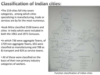
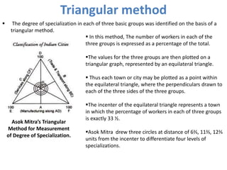
I’m professional presentation maker . These presentations are for sale for 20$ each, if required you can contact me on my gmail id bestpptmaker@gmail.com and you can also suggest me topics for your required presentations
City region is a term in use since about 1950 by urbanists, economists and urban planners to mean a metropolitan area and hinterland, often having a shared administration. Typically, it denotes a city, conurbation or urban zone with multiple administrative districts, but sharing resources like a central business district , labour market and transport network such that it functions as a single unit.
the concept of city regions
stages of urban development
kcro dmh kansas city mo
liverpool city region
global city region
sheffield city region
cardiff city website
urban development models
gayathrysatheesanslieshare
ciity region ppt
Geographic Regions: by definition There three types of regions Formal regions are areas where a certain characteristic is found throughout. Functional regions consist of a central place and the surrounding places affected by it. Perceptual regions are defined by people’s attitudes and feelings about areas. 4.
Definition,meaning, scope,approach, and aim of urban-geographyKamrul Islam Karim
What is Urban Geography?
It can be considered a sub-discipline of the larger field of human geography with overlaps of content with that of Cultural Geography
Definition of Urban Geography.
Urban geography is the study of urban places with reference to their geographical environment.
Urban geography is the sub discipline of geography which concentrates on those parts of the Earth's surface that have a high concentration of buildings and infrastructure
.
It is that branch of science, which deals with the study of urban areas, in terms of concentration, infrastructure, economy, and environmental impacts.
Griffith Taylor- Urban Geography includes the site revolution pattern and classification of towns.
Dudley Stamp- Urban Geography is infecting the intensive study of town and their development in all their geographical aspects.
Meaning of an Urban Place
UN Demographic Year Book concludes: “There is no point in the continuum from large agglomerations to small clusters or scattered dwellings where urbanity disappears and rurality begins the division between urban and rural populations is necessarily arbitrary.”
A review of the problems of rural and urban centres as revealed by the Census Reports of various countries identifies a few bases for reckoning a place as urban.
Difference between rural and urban depends upon their nature of work – the former being engaged in agricultural operations and the latter in non-agricultural activities.
Criteria of an Urban Place
(1) A place designated by administrative status;
(2) A minimum population;
(3) A minimum population density;
(4) A concept of contiguity to include or exclude under suburban area or loosely scattered settlement;
(5) A proportion engaged in non-agricultural occupations; and
(6) A functional character.
Attributes of Urban Geography
Scope/nature/theme of Urban Geography
Methods or Approaches of Urban Places
Aim of urban geography
This slide discusses about the core-periphery model given by John Friedmann. This model is basically a model of regional Development. You will able to learn about the core-periphery model very easily by this slide.
The primary aim of studying settlement geography is to acquaint with the spatial and structural characteristics of human settlements under varied environmental conditions.
Levels, Patterns and Trends of Urbanization (World)ShreemoyeeSaha1
1. What is Urbanization?
2. Levels of Urbanization in the World
3. Patterns of Urbanization in the World : Demographic Changes, Economic Development, Consumption Pattern, Urban Footprint.
4. Patterns of Urbanization in Asia.
5. Trends of Urbanization in the World : Past, Recent and Future Trends.
6. Timeline of Urbanization in the World (1950- 2050)
7. Projected Urban and Rural Population.
8. Urbanization and Sustainability.
Von thunen’s model of agricultural land useThe Urban Unit
This presentation is based on a agricultural land use model around the city. This is the theory of urban Geography it describe the agricultural pattern and how should the agricultural activities perform around the city. basically this Model was put forwarded before industrialization and when there was no roads networks and this Model is not applicable in real word but is gives great ideas for developing new towns and cities.
Concentric Zone Model Theory and Its Limitations. Concentric Zone Model Theory was created by sociologist EW Burgess in 1925. Based on a study of land use patterns and social group in Chicago. City grows outward beginning with the CBD. Similar & functionally related activities will locate at the same distance from CBD.
concentric zone theory paper
concentric zone theory articles
chicago's concentric zone theory
concentric zone model definition
concentric zone theory of crime
concentric zone model example
concentric zone model strengths
concentric zone theory and statistics
Region: A territorial area of similar characteristics, which is bigger than local area and smaller than the country / nation,
Regions in India, city region & linkages like economic, functional and transportation,
Rural-Urban Linkage,
Rural-Urban Fringe,
Urban periphery settlements: Urban Village and Unauthorised colony/ illegal-land sub-division,
Land Ceiling Repeal Act 1999
The concept of growth foci is one of the indispensable strategies for the regional development, which can be applied for the transformation of socio-economic activities of rural and urban settlements.
The growth foci have been identified with the help of certain indicators of administration, communication, education, health, finance, recreation, market and others.
Planning Chicago: An Historical Perspective on our Present-Day ProblemsTom Tresser
Presented by Prof. Brad Hunt, Roosevelt University, at the CivicLab, February 24, 2014. The CivicLab is America's only co-working space dedicated to collaboration, education and innovation for civic engagement. http://www.civiclab.us.
Settlement pattern of town (Varanasi) brief history of city evolve , settlement of institution and residents, concepts of the main ghats , master plan of Varanasi
Learn how ten million people in Mexico City came together to fight environmental damage, improve traffic congestion, improve air quality, open streets to bikes and pedestrians, and improve public health and civic pride.
URBAN FUNCTIONAL AND OCCUPATIONAL STRUCTURE IN NORTH 24 PARGANAS DISTRICT, WE...paperpublications3
Abstract: Function and occupation of towns are the crucial factor for urbanization and development .The paper analyzes functional classification of towns and occupational structure of towns in North 24 parganas district, by using Ashok Mitra functional classification method and occupational classification by census report 2011, on the basis of census data in 1971, 1991 and 2011. According to census data in 1971 and 1991 there are nine fold functional classifications and in 2011 only four fold occupational structures have been analyzed. Occupational structure also influences the socioeconomic development of any area.
Keywords: Urban function, urban occupation, urbanization, urban development.
Title: URBAN FUNCTIONAL AND OCCUPATIONAL STRUCTURE IN NORTH 24 PARGANAS DISTRICT, WEST BENGAL
Author: Chandan Sarkar
International Journal of Recent Research in Social Sciences and Humanities (IJRRSSH)
ISSN 2349-7831
Paper Publications
Indian History and Culture Delhi University's FYUP Foundation Course PowerPoi...Parth Nagpal
PowerPoint Presentation created for Delhi University's FYUP Foundation Course Indian History And Culture on the this topic-
On a map, plot ten towns which have now became big cities and discuss reasons for the same for two of those.
Urban Sprawl and its Impact on Urban EnvironmentIOSR Journals
This Paper an attempt has been made to examine the urban sprawl of Gorakhpur City through the land sat Images . Remote sensing and GIS to analyze the urban sprawl mapping and detect changes of urban sprawl of Gorakhpur city through different year. Satellite data are found to be useful in mapping and quantifying the extent of urban area in different time periods. New urban region development growing largely towards north, north-west and south-west direction along the main transport route of the city. New urban development occurs mainly on vegetation and agricultural land. This study provides a methodology for better estimation of urban growth and population using various land sat images with time. Geographical information system(GIS) and satellite images have been used in this study to provide spatial inputs and test the statistical model describing growth. This is useful for the urban planning in Developing Countries where land use data is not available regularly. GIS and Rescan help a lot in monitoring urban sprawl compared to Conventional technique
2024.06.01 Introducing a competency framework for languag learning materials ...Sandy Millin
http://sandymillin.wordpress.com/iateflwebinar2024
Published classroom materials form the basis of syllabuses, drive teacher professional development, and have a potentially huge influence on learners, teachers and education systems. All teachers also create their own materials, whether a few sentences on a blackboard, a highly-structured fully-realised online course, or anything in between. Despite this, the knowledge and skills needed to create effective language learning materials are rarely part of teacher training, and are mostly learnt by trial and error.
Knowledge and skills frameworks, generally called competency frameworks, for ELT teachers, trainers and managers have existed for a few years now. However, until I created one for my MA dissertation, there wasn’t one drawing together what we need to know and do to be able to effectively produce language learning materials.
This webinar will introduce you to my framework, highlighting the key competencies I identified from my research. It will also show how anybody involved in language teaching (any language, not just English!), teacher training, managing schools or developing language learning materials can benefit from using the framework.
The Roman Empire A Historical Colossus.pdfkaushalkr1407
The Roman Empire, a vast and enduring power, stands as one of history's most remarkable civilizations, leaving an indelible imprint on the world. It emerged from the Roman Republic, transitioning into an imperial powerhouse under the leadership of Augustus Caesar in 27 BCE. This transformation marked the beginning of an era defined by unprecedented territorial expansion, architectural marvels, and profound cultural influence.
The empire's roots lie in the city of Rome, founded, according to legend, by Romulus in 753 BCE. Over centuries, Rome evolved from a small settlement to a formidable republic, characterized by a complex political system with elected officials and checks on power. However, internal strife, class conflicts, and military ambitions paved the way for the end of the Republic. Julius Caesar’s dictatorship and subsequent assassination in 44 BCE created a power vacuum, leading to a civil war. Octavian, later Augustus, emerged victorious, heralding the Roman Empire’s birth.
Under Augustus, the empire experienced the Pax Romana, a 200-year period of relative peace and stability. Augustus reformed the military, established efficient administrative systems, and initiated grand construction projects. The empire's borders expanded, encompassing territories from Britain to Egypt and from Spain to the Euphrates. Roman legions, renowned for their discipline and engineering prowess, secured and maintained these vast territories, building roads, fortifications, and cities that facilitated control and integration.
The Roman Empire’s society was hierarchical, with a rigid class system. At the top were the patricians, wealthy elites who held significant political power. Below them were the plebeians, free citizens with limited political influence, and the vast numbers of slaves who formed the backbone of the economy. The family unit was central, governed by the paterfamilias, the male head who held absolute authority.
Culturally, the Romans were eclectic, absorbing and adapting elements from the civilizations they encountered, particularly the Greeks. Roman art, literature, and philosophy reflected this synthesis, creating a rich cultural tapestry. Latin, the Roman language, became the lingua franca of the Western world, influencing numerous modern languages.
Roman architecture and engineering achievements were monumental. They perfected the arch, vault, and dome, constructing enduring structures like the Colosseum, Pantheon, and aqueducts. These engineering marvels not only showcased Roman ingenuity but also served practical purposes, from public entertainment to water supply.
Operation “Blue Star” is the only event in the history of Independent India where the state went into war with its own people. Even after about 40 years it is not clear if it was culmination of states anger over people of the region, a political game of power or start of dictatorial chapter in the democratic setup.
The people of Punjab felt alienated from main stream due to denial of their just demands during a long democratic struggle since independence. As it happen all over the word, it led to militant struggle with great loss of lives of military, police and civilian personnel. Killing of Indira Gandhi and massacre of innocent Sikhs in Delhi and other India cities was also associated with this movement.
Unit 8 - Information and Communication Technology (Paper I).pdfThiyagu K
This slides describes the basic concepts of ICT, basics of Email, Emerging Technology and Digital Initiatives in Education. This presentations aligns with the UGC Paper I syllabus.
How to Make a Field invisible in Odoo 17Celine George
It is possible to hide or invisible some fields in odoo. Commonly using “invisible” attribute in the field definition to invisible the fields. This slide will show how to make a field invisible in odoo 17.
Biological screening of herbal drugs: Introduction and Need for
Phyto-Pharmacological Screening, New Strategies for evaluating
Natural Products, In vitro evaluation techniques for Antioxidants, Antimicrobial and Anticancer drugs. In vivo evaluation techniques
for Anti-inflammatory, Antiulcer, Anticancer, Wound healing, Antidiabetic, Hepatoprotective, Cardio protective, Diuretics and
Antifertility, Toxicity studies as per OECD guidelines
Macroeconomics- Movie Location
This will be used as part of your Personal Professional Portfolio once graded.
Objective:
Prepare a presentation or a paper using research, basic comparative analysis, data organization and application of economic information. You will make an informed assessment of an economic climate outside of the United States to accomplish an entertainment industry objective.
The French Revolution, which began in 1789, was a period of radical social and political upheaval in France. It marked the decline of absolute monarchies, the rise of secular and democratic republics, and the eventual rise of Napoleon Bonaparte. This revolutionary period is crucial in understanding the transition from feudalism to modernity in Europe.
For more information, visit-www.vavaclasses.com
Read| The latest issue of The Challenger is here! We are thrilled to announce that our school paper has qualified for the NATIONAL SCHOOLS PRESS CONFERENCE (NSPC) 2024. Thank you for your unwavering support and trust. Dive into the stories that made us stand out!
1. DEMOGRAPHY & URBANIZATION
FUNCTIONAL CLASSIFICATION OF
URBAN CENTERS
DEPARTMENT OF URBAN & REGIONAL PLANNING
School Of Planning & Architecture
JNAFAU
T.S.GURURAJA
14011BA030
B.TECH PLANNING
2ND SEMESTER
SUBMITTED TO:
Mrs. TUHINA SINHA
SUBMITTTED BY:
2. •Cities may be classified on the basis of the types of economic activity carried on within
the city. Certain economic activities have acquired greater significance than others.
•The presence of an iron and steel industry and textile industry lends a certain name
and character to the city. Some cities are known for their administrative status as state
or district capitals.
•The range of economic activities in a city covers the entire spectrum of primary,
secondary and tertiary activities.
•In the Indian context, primary activities are very much apart of the urban scene, as
nearly a third of India’s urban places have agriculture as relatively the most dominant
economic activity.
•The classification of cities based on the relative importance of primary, secondary and
tertiary activities.
•Cities show a remarkable degree of specialization in one or more specific activities,
such as trade, transport, house hold industry, modern industry, public administration
and so on.
3. According to the 1961 &1971 censuses, all towns and cities are provided for 9
industrial categories of workers.
• The categories are:
1.Cultivation
2.Agricultural labour
3.Forestry,fishing,plantation,mining,etc.
4.House hold industry
5.Manufacturing other than house hold industry
6.Costruction
7.Trade and commerce
8.Transport, storage and communication
9.Services
This classification of workers closely corresponds to the Standard Industrial Classification of
workers at the first digit level.
Primary sector
Secondary sector
Tertiary sector
• Primary and secondary sector related to agriculture, which is not considered as an urban
economic activity. The third sector has a mix of urban and non urban activities.
• Urban areas , however, have a larger proportion of workers in the secondary and tertiary
sectors. It is this aspect that is relevant to the economic classification of India’s urban places.
4. • The census industrial categories form the basis for a functional classification of
urban places. The term ‘function 'in a fact refers to an economic activity in town,
weather at the primary, secondary or tertiary level.
• The definition of ‘function’ will be used, wherein the primary and secondary sectors
are totally excluded, while only a restricted range of tertiary activities are included.
• For purpose of city classification such a restricted interpretation of the term is not
desirable.
• In the early 1950s, it was considered appropriate to classify urban places on the
basis of their dominant function. Further, The number of workers is not always the
best measure of the importance's of the an economic activity .
• The functional classification of cities has been replaced by the multiple function
approach.
• India’s cities were first classified in terms of functional categories by Amrit Lal using
the 1951 census data.
5. • The classification, how ever, suffer from a number of methodological deficiencies,
and infact does not even list the one lakh of 67cities according to the functional
groups in to which they have been divided .
• Ashok mitra has attempted a classification of all towns and cities common to the
1961 and 1971 censuses.
• The factor analytical method and various grouping procedures were also adopted
by Qazi Ahmad for classifying the one lakh cities of India in 1961.
• Of the two methods employed by Mitra , the earlier method is more satisfactory
and the second classification employs quantitative procedure of factor and cluster
analysis.
• Quazi Ahmad used to many variable with no selectivity while Asoka mitra used
too few variables representing only the economic or functional aspect.
6. •The 219 cities fall into seven
categories, among which cities
specializing in manufacturing, trade or
services are by far the most numerous.
•Asok Mitra classified 2528 towns and
cities in India which were included in
both the 1961 and 1971 Censuses.
•In which 736 were aggregate Towns, of
1729 non-aggregate Towns, 655 were
classified as manufacturing and 708 as
& transport and 429 as service towns.
• All of these were classified on the
basis of their non primary industry
categories of workers.
Function classification of indian cities
7. Functional Classification by Asok Mitra
A through classification of all urban places in India was attempted by Asok Mitra. He
grouped the seven industrial categories of workers into three broad groups to derive
three major functional types:
A. Manufacturing town: where the percentage of workers in the industrial
categories of 3,4,5&6 put together than the percentage of workers in categories
7&8 put together or percentage of workers in category 9.
B. Trade and transport town: where the percentage of workers in categories 7&8
together is greater than in category 9 or in categories 3,4,5 and 6 put together.
C. Service town: Where the percentage of workers in category 9 is greater than the
total percentage of workers in categories 7&8.
The manufacturing towns and trade and transport towns were further sub classified as
follows: 1.Miningand quarrying, livestock, forestry. fishing or plantation town
2.Artisan town
3.Manufacturing town
4.Construction town
5.Trade town
6.Transport town
8. Triangular method
The degree of specialization in each of three basic groups was identified on the basis of a
triangular method.
Asok Mitra’s Triangular
Method for Measurement
of Degree of Specialization.
In this method, The number of workers in each of the
three groups is expressed as a percentage of the total.
The values for the three groups are then plotted on a
triangular graph, represented by an equilateral triangle.
Thus each town or city may be plotted as a point within
the equilateral triangle, where the perpendiculars drawn to
each of the three sides of the three groups.
The incenter of the equilateral triangle represents a town
in which the percentage of workers in each of three groups
is exactly 33 ½.
Asok Mitra drew three circles at distance of 6⅔, 11⅔, 12⅔
units from the incenter to differentiate four levels of
specializations.
9. He designed degrees of specialization as follows:
Degree of Specialization Code Location in circle
1.Predominant Function PEHA Outside the outer circle (3rd circle).
2.Predominant Function Accentuated PFA Between the 2nd & 3rd circle.
3. Functions Moderately Diversified FMD Between the 1st & 2nd circles.
4.Functions Highly Diversified FHD With in the first circle.
Functional Classification of Indian cities (By Asok Mitra)
City type Code Degrees of Specialization Total no. of cities
FHD FMD PFA PEHA
1. Manufacturing MMT 17 28 9 26 80
2.Artisan MA 2 2 2 2 8
3.Mining MMg - - 1 1 2
4.Plantation Mp - - - 1 1
5.Trading TTg 22 35 18 3 78
6.Transport TTt - 1 3 5 9
7.Services SS 8 15 12 6 41
Total 49 81 45 44 219
10. Classification of cities:
The one-lakh cities, classified by asok mitra along with the smaller
towns, are easier to examine in terms of the range of specialization &
spatial patterns.
The 219 cities (1981) fall into even categories, among which cities
specializing in manufacturing, trade or service are by far the most
numerous.
There are 80 manufacturing cities, 78 trading cities & 41 service cities.
Only 3 trading cities & 6 service cities how such a high level of
specialization.
The leading manufacturing cities which show clear which show clear
specialization are Ahmadabad, surat, Jamshedpur, Ulhasnagar, Ludhiana,
Salem, Sholapur.
11. Manufacturing cities are distributed widely all over the country-from Tamil Nadu in
the south to Bihar & Uttar Pradesh in the north & Maharashtra & Gujarat in the west.
The three cities which have a high degree of specialization in trade are Vijayawada in
Andhra Pradesh, siliguri in west Bengal and katihar in Bihar
The artisan cities are few in number, eight in all. Of thee, Kancheepuram in Tamil
Nadu & sagar in Madhya Pradesh have a high degree of specialization. Other cities in
this category are Varanasi, Bhagalpur, nagarcoil, imphal, sambal gondia.
Transportation I a major specialization of the cities of the cities in the coal mining
area, namely, dhanbad, asansol, nodal.
The railway cities kharagpur & bhusawal also have a high degree of specialization in
transportation.
Valparaiso in the anamalai hills of Tamil nadu is the only city with a specialization in
the plantation (tea) industry, while kolar gold fields in Karnataka & bermo in Bihar have
specialization in mining activities.
12. ASHOK MITRA’S classification, on the whole, does bring out the major categories on the basis of
their broad economic activities.
In particular, it succeeds in differentiating the manufacturing, trading and service cities.
The vast majority of India cities, however, have no clear specialization in any one economic
activity and infact have a diversified economic base. Specialization appears, on the whole, as the
expectation rather the rule. Nevertheless, manufacturing cities do appear as a major subtype
among Indian cities, and stand in contrast to the general run of diversified cities.
Specialization in trade, service, mining or transport occurs only in a handful of cities. Though
these are the important deviant or exceptional cases, their numbers are too significant.
The diversified city with the multiple functions including manufacturing, trade and service
constitutes the most common and representative type of city. The Indian urban system is indeed
basically a system of diversified cities.
13. Any descriptive classification suffers the drawback of not having a sufficient theoretical base
which might enable it a wider application. This was later rectified by the use of statistical
techniques to determine which was really the dominant function so as to help create a proper
scale of reference for classification.
Problems in urban classification arise mainly when the level of measurement of urban
characteristics is raised to the interval scale. Here urban places are differentiated on the basis of
single or multiple criteria or variables.
Towns and cities may be classified on the basis of their site characteristics as sea front, river
front, flat land or hilly cities.
They may be classified on the basis of their social attributes as Hindu cities, Muslim cities,
Christian cities.
Ex: Urban places may be classified on the basis of their administrative status as national capital,
state capitals, district head quarters.
The factor analytical method used for classification of India’s urban places by Qazi Ahmed and
Asok Mitra, have generated more doubts and ambiguities.
The utility and meaningfulness of the outcome is the only criterion for judging the value of a
classification.
14. THANK YOU
Urbanization and Urban Systems in India
-By R.Ramachandran
Urbanization Migration & Economic Development
-By M.Koteswara Rao
Introduction to Settlement Geography
-Sumita Ghosh
References: