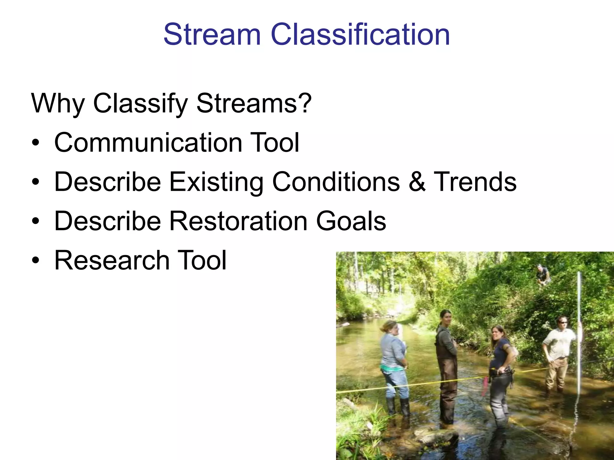
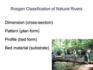
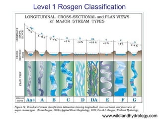
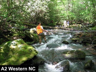
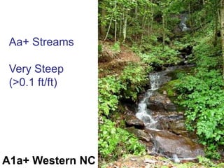
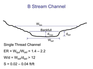
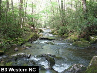
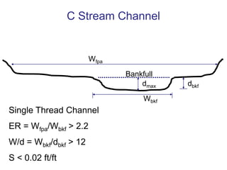
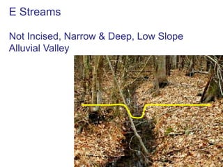
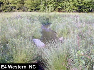
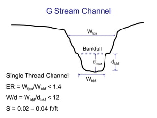
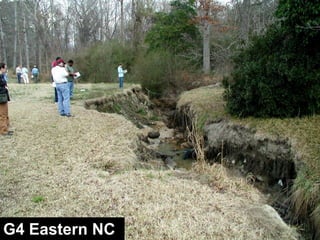
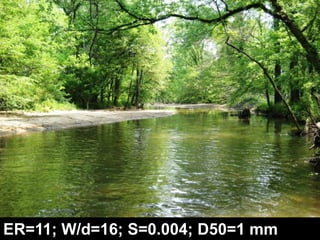
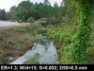
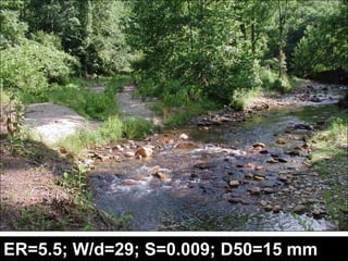
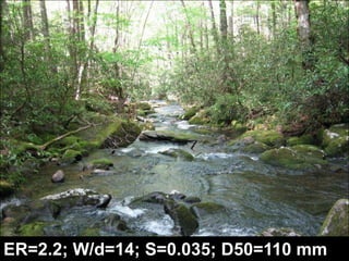
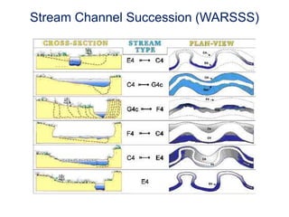
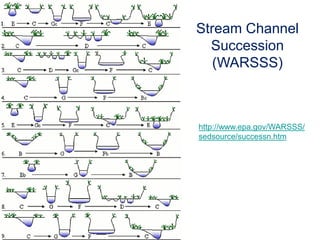
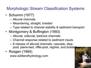
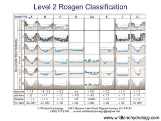
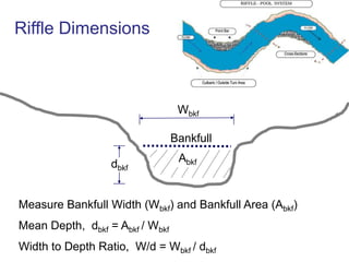
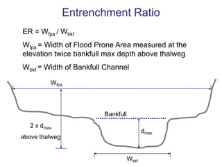
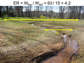
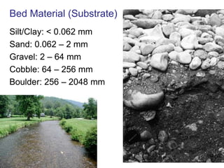
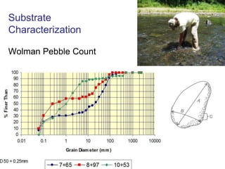
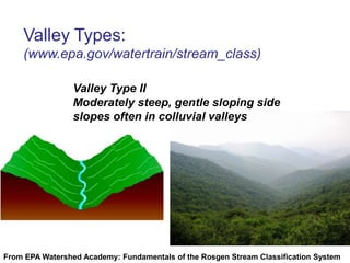
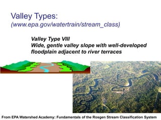
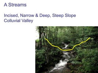
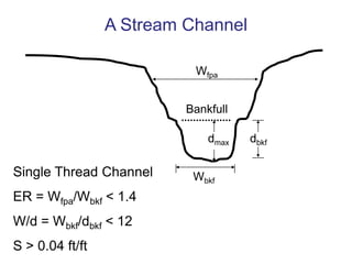
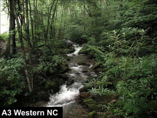
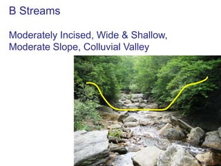
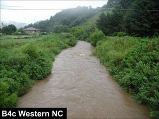
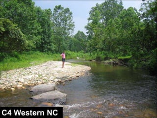
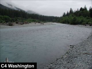
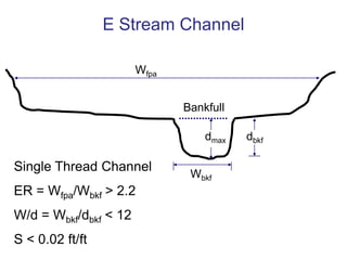
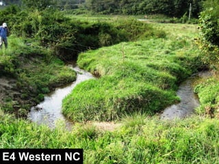
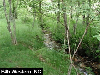
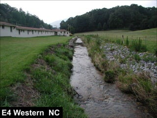
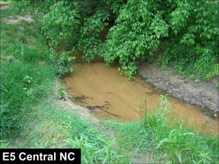
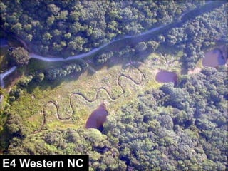
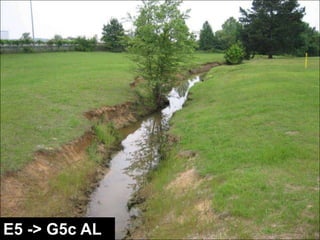
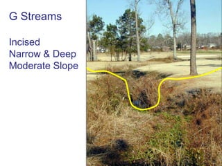
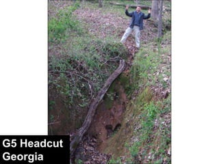
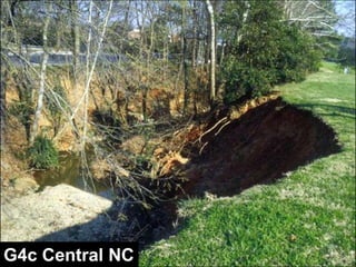
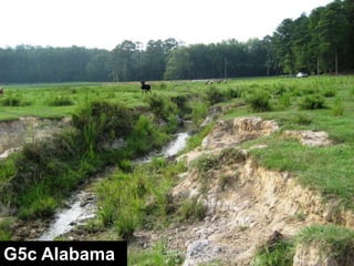
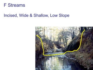
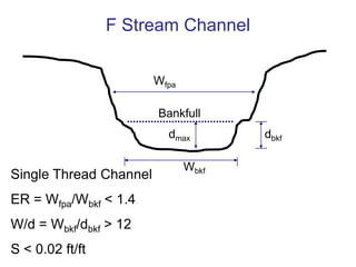
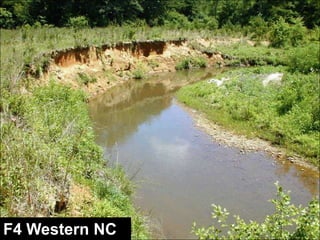
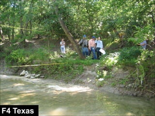
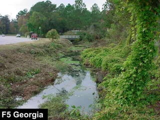
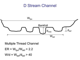
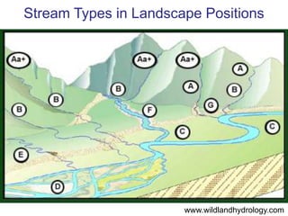
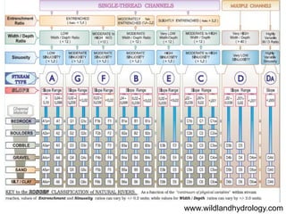
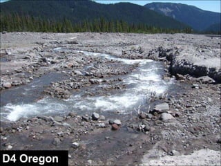
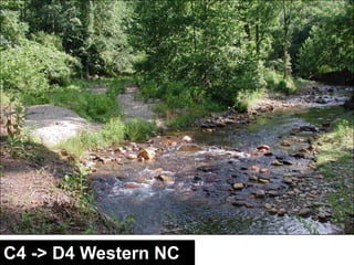
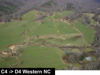
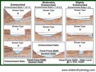
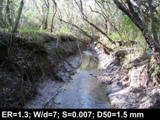
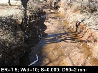
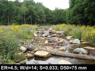
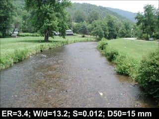
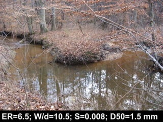
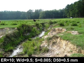
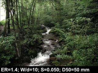
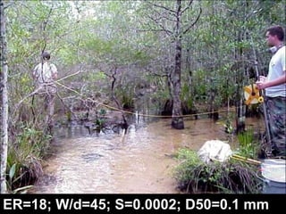
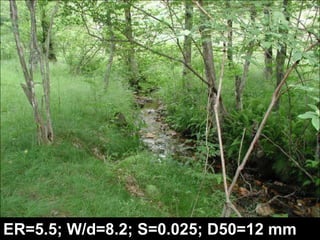
Stream ClassificationWhy Classify Streams?Communication Tool
Describe Existing Conditions & Trends
Describe Restoration Goals
Research ToolMorphologic Stream Classification SystemsSchumm (1977)Alluvial channelsMeandering, straight, braidedType related to channel stability & sediment transportMontgomery & Buffington (1993)Alluvial, colluvial, bedrock channelsChannel response related to sediment inputs6 classes of alluvial channels: cascade, step-pool, plane-bed, riffle-pool, regime, and braidedRosgen (1994)www.wildlandhydrology.com
Rosgen Classification of Natural RiversBased on physical characteristics (empirical)Requires field measurementsRequires bankfull dimensionswww.wildlandhydrology.com
What factors affect stream morphology?Width
Depth
Slope
Velocity
Discharge
Flow resistance
Sediment size
Sediment loadLeopold et al (1964)
Rosgen Classification of Natural RiversDimension (cross-section)Pattern (plan form)Profile (bed form)Bed material (substrate)
Level 1 Rosgen Classificationwww.wildlandhydrology.comwww.wildlandhydrology.com
Level 2 Rosgen Classificationwww.wildlandhydrology.comwww.wildlandhydrology.com
www.wildlandhydrology.com
Stream Types in Landscape Positionswww.wildlandhydrology.com
A StreamsIncised, Narrow & Deep, Steep SlopeColluvial Valley
A Stream ChannelWfpaBankfulldbkfdmaxSingle Thread ChannelER = Wfpa/Wbkf < 1.4W/d = Wbkf/dbkf < 12S > 0.04 ft/ftWbkf
A2 Western NC
Aa+ StreamsVery Steep(>0.1 ft/ft)A1a+ Western NC
B StreamsModerately Incised, Wide & Shallow, Moderate Slope, Colluvial Valley
B Stream ChannelWfpaBankfulldbkfdmaxWbkfSingle Thread ChannelER = Wfpa/Wbkf = 1.4 – 2.2W/d = Wbkf/dbkf > 12S = 0.02 – 0.04 ft/ft
www.wildlandhydrology.com
B3 Western NC
C StreamsNot Incised, Wide & Shallow, Low SlopeAlluvial Valley
C Stream ChannelWfpaBankfulldbkfdmaxWbkfSingle Thread ChannelER = Wfpa/Wbkf > 2.2W/d = Wbkf/dbkf > 12S < 0.02 ft/ft
www.wildlandhydrology.com
C4 New Zealand
C4 Utah
E StreamsNot Incised, Narrow & Deep, Low SlopeAlluvial Valley
E Stream ChannelWfpaBankfulldbkfdmaxSingle Thread ChannelER = Wfpa/Wbkf > 2.2W/d = Wbkf/dbkf < 12S < 0.02 ft/ftWbkf
www.wildlandhydrology.com
E4 Western NC
E4 Central NC
E4b Western  NC
E4 Western NC
E4 Western  NC
G StreamsIncisedNarrow & DeepModerate Slope
G Stream ChannelWfpaBankfulldbkfdmaxSingle Thread ChannelER = Wfpa/Wbkf < 1.4W/d = Wbkf/dbkf < 12S = 0.02 – 0.04 ft/ftWbkf
www.wildlandhydrology.com
G4 Western NC
G4 Eastern NC
G4c Central NC
G5c Alabama
G4
F StreamsIncised, Wide & Shallow, Low Slope
F Stream ChannelWfpaBankfulldbkfdmaxWbkfSingle Thread ChannelER = Wfpa/Wbkf < 1.4W/d = Wbkf/dbkf > 12S < 0.02 ft/ft
Stream Types in Landscape Positionswww.wildlandhydrology.com
www.wildlandhydrology.com
F4 Texas
F4 Alabama
F5 South Carolina
Ugg Texas
D & DA StreamsMultiple Channels, Wide & Shallow, Low SlopeD4 Virginia
D Stream ChannelWfpaBankfulldbkfdmaxWbkfMultiple Thread ChannelER = Wfpa/Wbkf > 2.2W/d = Wbkf/dbkf > 40
Stream Types in Landscape Positionswww.wildlandhydrology.com
www.wildlandhydrology.com
D4 New Zealand
D4 Pennsylvania
C4 -> D4 Western NC
ER=11; W/d=16; S=0.004; D50=1 mm
ER=1.3; W/d=7; S=0.007; D50=1.5 mm
ER=2.2; W/d=14; S=0.024; D50=75 mm
ER=6.5; W/d=10.5; S=0.008; D50=1.5 mm
ER=1.5; W/d=10; S=0.009; D50=2 mm
ER=1.4; W/d=10; S=0.050; D50=50 mm
ER=1.3; W/d=15; S=0.002; D50=0.5 mm
ER=1.3; W/d=7; S=0.007; D50=1.5 mm
ER=5.5; W/d=29; S=0.009; D50=15 mm
ER=2.2; W/d=14; S=0.035; D50=110 mm
ER=5.5; W/d=8.2; S=0.025; D50=12 mm
ER=2.1; W/d=15; S=0.065; D50=120 mm
ER=2.2; W/d=14; S=0.024; D50=75 mm
Stream Channel Succession (WARSSS)
Stream Channel Succession (WARSSS)http://www.epa.gov/WARSSS/sedsource/successn.htm
Bank ErosionMonitoring
Bank Erosion Hazard Index (BEHI)
Stream ClassificationWhy Classify Streams?Communication Tool
Describe Existing Conditions & Trends
Describe Restoration Goals
Research ToolMorphologic Stream Classification SystemsSchumm (1977)Alluvial channelsMeandering, straight, braidedType related to channel stability & sediment transportMontgomery & Buffington (1993)Alluvial, colluvial, bedrock channelsChannel response related to sediment inputs6 classes of alluvial channels: cascade, step-pool, plane-bed, riffle-pool, regime, and braidedRosgen (1994)www.wildlandhydrology.com
Rosgen Classification of Natural RiversBased on physical characteristics (empirical)Requires field measurementsRequires bankfull dimensionswww.wildlandhydrology.com
What factors affect stream morphology?Width
Depth
Slope
Velocity
Discharge
Flow resistance
Sediment size
Sediment loadLeopold et al (1964)
Rosgen Classification of Natural RiversDimension (cross-section)Pattern (plan form)Profile (bed form)Bed material (substrate)
Level 1 Rosgen Classificationwww.wildlandhydrology.comwww.wildlandhydrology.com
Level 2 Rosgen Classificationwww.wildlandhydrology.comwww.wildlandhydrology.com
Riffle DimensionsWbkfBankfullAbkfdbkfMeasure Bankfull Width (Wbkf) and Bankfull Area (Abkf)Mean Depth,  dbkf = Abkf / WbkfWidth to Depth Ratio,  W/d = Wbkf / dbkf
W/d = 9.3 / 1.5 = 6.2 WbkfdbkfAbkf
Entrenchment RatioER = Wfpa / WbkfWfpa = Width of Flood Prone Area measured at the elevation twice bankfull max depth above thalwegWbkf = Width of Bankfull ChannelWfpaBankfull2 x dmaxabove thalwegdmaxWbkf
ER = Wfpa / Wbkf = 63/ 15 = 4.2 WfpaWbkf
Bed Material (Substrate)Silt/Clay: < 0.062 mmSand: 0.062 – 2 mmGravel: 2 – 64 mmCobble: 64 – 256 mmBoulder: 256 – 2048 mm
Substrate CharacterizationWolman Pebble Count
www.wildlandhydrology.com
Valley Types:  (www.epa.gov/watertrain/stream_class)Valley Type II Moderately steep, gentle sloping side slopes often in colluvial valleysFrom EPA Watershed Academy: Fundamentals of the Rosgen Stream Classification System
Valley Types:  (www.epa.gov/watertrain/stream_class)Valley Type VIII Wide, gentle valley slope with well-developed floodplain adjacent to river terracesFrom EPA Watershed Academy: Fundamentals of the Rosgen Stream Classification System
Stream Types in Landscape Positionswww.wildlandhydrology.com
A StreamsIncised, Narrow & Deep, Steep SlopeColluvial Valley
www.wildlandhydrology.com
A Stream ChannelWfpaBankfulldbkfdmaxSingle Thread ChannelER = Wfpa/Wbkf < 1.4W/d = Wbkf/dbkf < 12S > 0.04 ft/ftWbkf
A2 Western NC
A2 Montana
A3 Western NC
Aa+ StreamsVery Steep(>0.1 ft/ft)A1a+ Western NC
A1a+ Western NC
A1a+ Tennessee
B StreamsModerately Incised, Wide & Shallow, Moderate Slope, Colluvial Valley
B Stream ChannelWfpaBankfulldbkfdmaxWbkfSingle Thread ChannelER = Wfpa/Wbkf = 1.4 – 2.2W/d = Wbkf/dbkf > 12S = 0.02 – 0.04 ft/ft
Stream Types in Landscape Positionswww.wildlandhydrology.com
www.wildlandhydrology.com
B3 Western NC
B3 Western NC
B3 Western NC
B4 Tennessee
B3 Western NC
B4 Western NC
B4c Western NC
C StreamsNot Incised, Wide & Shallow, Low SlopeAlluvial Valley
C Stream ChannelWfpaBankfulldbkfdmaxWbkfSingle Thread ChannelER = Wfpa/Wbkf > 2.2W/d = Wbkf/dbkf > 12S < 0.02 ft/ft
Stream Types in Landscape Positionswww.wildlandhydrology.com
www.wildlandhydrology.com
C4 Western NC
C4 Western NC
C4 Washington
C4 New Zealand
C4 Western NC
C5 Alabama
C4 Utah
C4 Western NC
E StreamsNot Incised, Narrow & Deep, Low SlopeAlluvial Valley
E Stream ChannelWfpaBankfulldbkfdmaxSingle Thread ChannelER = Wfpa/Wbkf > 2.2W/d = Wbkf/dbkf < 12S < 0.02 ft/ftWbkf
Stream Types in Landscape Positionswww.wildlandhydrology.com
www.wildlandhydrology.com
E4 Western NC
E4 Central NC
E4 Central NC
E4 Western NC
E4 Western NC
E4b Western  NC
E4 Western  NC
E5 Central NC
E4 Central NC
E4 Western NC
E4 Western  NC
E5 -> G5c AL
G StreamsIncisedNarrow & DeepModerate Slope
G Stream ChannelWfpaBankfulldbkfdmaxSingle Thread ChannelER = Wfpa/Wbkf < 1.4W/d = Wbkf/dbkf < 12S = 0.02 – 0.04 ft/ftWbkf
Stream Types in Landscape Positionswww.wildlandhydrology.com
www.wildlandhydrology.com
G4 Western NC
G4 Eastern NC
G5 Headcut Georgia
G5 Headcut Georgia
G4c Central NC
G4c Alabama
G4c Alabama
G5c Eastern NC
G5c Alabama
G5c Florida
G4
2000200120032003
F StreamsIncised, Wide & Shallow, Low Slope
F Stream ChannelWfpaBankfulldbkfdmaxWbkfSingle Thread ChannelER = Wfpa/Wbkf < 1.4W/d = Wbkf/dbkf > 12S < 0.02 ft/ft
Stream Types in Landscape Positionswww.wildlandhydrology.com
www.wildlandhydrology.com
F1 Asheville
F2 New Zealand
F2 New Zealand
F3 New Zealand
F4 Western NC
F4 Texas
F4 Texas
F4 Alabama
F5 Georgia
F5 South Carolina
Ugg Texas
D & DA StreamsMultiple Channels, Wide & Shallow, Low SlopeD4 Virginia
D Stream ChannelWfpaBankfulldbkfdmaxWbkfMultiple Thread ChannelER = Wfpa/Wbkf > 2.2W/d = Wbkf/dbkf > 40
Stream Types in Landscape Positionswww.wildlandhydrology.com
www.wildlandhydrology.com
D4 Georgia
D4 New Zealand
D4 Oregon
D4 Pennsylvania
C4 -> D4 Western NC
C4 -> D4 Western NC
DA5 Florida
www.wildlandhydrology.com
ER=11; W/d=16; S=0.004; D50=1 mm

Rc101 day2