
More Related Content
Viewers also liked
Viewers also liked (20)
Similar to POLITICAL MAPS, SPANISH INSTITUTIONS/CULTURE
Similar to POLITICAL MAPS, SPANISH INSTITUTIONS/CULTURE (20)
Recently uploaded
Recently uploaded (20)
POLITICAL MAPS, SPANISH INSTITUTIONS/CULTURE
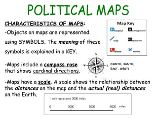
- 1. CHARACTERISTICS OF MAPS: -Objects on maps are represented using SYMBOLS. The meaning of these symbols is explained in a KEY. -Maps include a compass rose that shows cardinal directions. -Maps have a scale. A scale shows the relationship between the distances on the map and the actual (real) distances on the Earth. (NORTH, SOUTH, EAST, WEST)
- 3. POLITICAL MAPS: they show countries, their borders and capital cities. COUNTRIES BORDERS CAPITAL CITY
- 4. GEOGRAPHIC COORDINATES: To describe geographical locations on Earth, we use a system of imaginary lines called parallels and meridians. Parallels are circular lines that go around the Earth from East to West. The longest parallel, the Equator, divides the Earth into the northern hemisphere and the southern hemisphere. LATITUDE is the distance in degrees from the Equator (0º). Meridians are circular lines that go from North to South and pass throuth the poles. Meridians are the same lenght. The Prime Meridian, also called the Greenwich Meridian, divides the Earth into the eastern hemisphere and the western hemisphere. LONGITUDE is the distance in degrees from the Prime Meridian (0º).
- 6. GLOBES AND WORLD MAPS: GLOBES are more accurate than MAPS for representing the Earth, because they are three-dimensional like the Earth itself. Once you try to reproduce the surface of the Earth on a flat map, the sizes and shapes get distorted. Some countries appear larger than they really are. GLOBES WORLD MAP
- 7. The CONSTITUTION is the most important law in Spain. It was approved on 6 DECEMBER 1978. It defines: -The organisation of the Spanish TERRITORY. -The organisation of the GOVERNMENT. And, -The Rights and Responsibilities of the citizens. The Constitution also establishes: -The FLAG: three horizontal stripes (red, yellow and red).
- 8. -The NATIONAL ANTHEM: it’s called the “Marcha Real” (Royal March) and it has no official lyrics. -The COAT OF ARMS. It usually appears on the flag of Spain. The Constitution establishes Spain as a PARLIAMENTARY MONARCHY. This means that the king or queen is the Head of State BUT Parliament is responsible for making and approving new laws. Felipe VI is the Head of State. He represents Spain in international relations. The Crown of Spain is hereditary.
- 9. The Constitution establishes THREE POWERS: 1) LEGISLATIVE POWER. The main function is to make or develop laws. Parliament (Las Cortes Generales) is made up of two parts: 1-The Congress of Deputies and 2-The Senate. Citizens of Spain who are 18 years old or over, vote for members of Parliament in general elections every four years. 2) EXECUTIVE POWER. After the general elections, the political party with the most votes forms the Government. The Prime Minister is the head of the Government. The ministers are appointed by the Prime Minister. They work in different areas (education, healthcare, defence, economy).
- 10. 3) JUDICIAL POWER. It belongs to courts and tribunals, composed by judges and magistrates. They make sure that the laws are obeyed. The judicial bodies in Spain are: + The Supreme Court: it’s the highest court. + The Constitutional Court: it decides if laws introduced by Parliament are in accordance with the Constitution. AUTONOMOUS COMMUNITIES Spain is divided into 17 Autonomous Communities and two Autonomous Cities: Ceuta and Melilla. Autonomous Communities are made up of one or more PROVINCES. Each province is divided into MUNICIPALITIES.
- 11. Spain’s unique culture is a result of its location, as well as the influence from different civilisations such as Celts, Visigoths, Romans and Muslims. Spanish cuisine is extremely diverse and uses a variety of different ingredients and techniques. Each region has its own unique cuisine. However, there are some dishes which are considered national dishes such as Spanish omelette, cured ham and cured pork sausage to name just a few.
- 12. Spain’s official language is Spanish, also called Castilian. Spanish is not the only language spoken in Spain. Languages such as Catalan, Basque and Galician have co- official status. There are also a number of unofficial languages or dialects that are spoken in certain places.