1) Earthquakes regularly occur at plate boundaries in the oceans, such as at subduction zones where one tectonic plate slides under another.
2) Major earthquakes can generate destructive tsunamis by displacing large volumes of water very quickly. These tsunami waves travel across the ocean and grow in height as they reach shorelines.
3) Studying areas like the Nankai Trough off Japan, where great earthquakes repeatedly occur, can provide insights into why and how these quakes happen, and help determine areas at risk for future seismic events.
Earth and Life Science
Earth Materials and Processes: Deformation of the Crust
The learners shall be able to:
1) explain how the seafloor spreads (S11/12ESId-23);
2) describe the structure and evolution of ocean basins (S11/12ES-Id-24); and
3) explain how the movement of plates leads to the formation of folds and faults (S11/12ES-Id-22).
Specific Learning Outcomes
At the end of the lesson, the learners will be able to:
1. Discuss the history behind the Theory of Continental Drift;
2. Describe the Continental Drift Theory;
3. Enumerate and explain the evidence used to support the idea of drifting continents;
4. Identify major physiographic features of ocean basins
5. Describe the process of seafloor spreading
What is Plate tectonics? In this presentation, you will be able to learn about Plate Tectonic Theory, the Plate Boundaries, as well as the Evidences of Plate Movement.
What is Plate tectonics? In this presentation, you will be able to learn about Plate Tectonic Theory, the Plate Boundaries, as well as the Evidences of Plate Movement.
Here is an easy to read information about our Oceans and what controls them and how mankind affects it. It includes visuals to help understand the different processes that make the motion. This includes currents, garbage patch, El Nino, ocean features and human impact. This was a school report so includes some other materials.
RUNNING HEAD Rough Draft-Peer reviewPage 1PEER REVIEW.docxtoltonkendal
RUNNING HEAD: Rough Draft-Peer review Page 1
PEER REVIEW Page 7
ROUGH DRAFT
A few minutes of intense shaking, followed by a devastating tsunami, producing widespread destruction. FEMA's best-case scenario, 13,000 people will lose their lives, (Schultz, 2015). The question is not if it's going to happen, it's when. The countdown to catastrophe is on for the Pacific Northwest. We're talking about the Cascadia Subduction Zone. Throughout this paper, I will discuss the who, what, where, when, and how this overdue megaquake will strike.
The Cascadia subduction zone is a 620-mile-long crack in the earth's crust. It is in the pacific northwest where the North American tectonic plate meets the Juan de Fuca plate, (Tarbuck, Lutgens, Tasa, 2017). Tectonic plates are pieces of crust that move across the earth's surface over millions of years, (Oskin, 2015). The subduction zone is where two tectonic plates meet. One eventually bends underneath the other, which is what we see in the North Pacific. The Juan de Fuca plate is sliding under the weaker, North American plate. Eventually, the North American plate will buckle, result in a devastating earthquake, followed by massive Tsunami.
Subduction zones are found all along the edge of the Pacific in what is called, "The ring of fire." Off the coasts of Washington, Canada, Alaska, Russia, and Indonesia birthed the most devastating earthquakes, tsunamis and volcanic eruptions in history, (Oskin, 2015). The bigger the subduction zone, the higher magnitude of the earthquake. A subduction zone earthquake with a magnitude of 7.5 or greater will likely produce a tsunami. The Cascadia subduction zone is a big one. It runs 620 miles long and 62 miles wide. It has all the ingredients necessary to produce massive devastation.
So how do we know that the Pacific Northwest is in danger? Tsunamis are a direct result of an earthquake, volcanic eruption or a massive landslide. The once dubbed, "Orphan Tsunami," hit the eastern coast of Japan on January 27th, 1700, (Atwater et al., 2015). The year 1700 in the Pacific Northwest was considered prehistory, meaning there were no written records of events. Japan, on the other hand, have produced numerous ancient writings of stories that told of flooded fields, wrecked houses, fire, a shipwreck, and evacuations. The Japanese knew that tsunamis were a result of an earthquake, and because they didn't feel any shaking prior, they called the event a high tide. At the time, it wasn't known that tsunamis could occur from earthquakes that happened from faraway lands. Outsiders of Northwestern North America scarcely knew of its existence. At that time, leading European geographers left that part of the map blank. So, for this mystery, the Japanese didn't even know the Pacific Northwest existed, much less that it had produced the earthquake that generated the tsunami, (Atwater et al., 2015).
The Chilean earthquake that struck on May 22, 1960, generated a tsunami that surged a ...
The topic of plate tectonics is largely based on Alfred Wegner's theory of continental drift, which became accepted with the discovery of seafloor spreading in the Atlantic Ocean, and after fossil, flora, and geological studies in Africa and South America. In this lesson, students will learn about Earth’s structure, differences between various types of tectonic plate boundaries, their outcomes, and their connection to locations of volcanoes and earthquake activity.
that is associated with broad upwarping of the overlying litho.docxmattinsonjanel
that is associated with broad upwarping of the overlying lithosphere (figure 5.1 iA). As a result, the lithosphere is stretched, causing the brittle crustal rocks to break into large slabs. As the tectonic forces continue to pull the crust apart, these crustal fragments sink, generating an elongated depression called a continental rift (figure 5.1 ib).
A modern example of an active continental rift is the East African Rift (figure s. i 2). Whether this rift will eventually result in the breakup of Africa is a topic of continued research. Nevertheless, the East African Rift is an excellent model of the initial stage in the breakup of a continent. Here, tensional forces have stretched and thinned the crust, allowing molten rock to ascend from the mantle. Evidence for recent volcanic activity includes several large volcanic mountains including Mount Kilimanjaro and Mount Kenya, the tallest peaks in Africa. Research suggests that if rifting continues, the rift valley will lengthen and deepen, eventually extending out to the margin of the landmass (r;<;ur.E 5.1 ic). At this point, the rift will become a narrow sea with an outlet to the ocean. The Red Sea, which formed when the Arabian Peninsula split from Africa, is a modern example of such a feature. Consequently, the Red Sea provides us with a view of how the Atlantic Ocean may have looked in its infancy (figure 5.1 id).
QEOD^
Forces Within sSWHBe Plate Tectonics
New lithosphere is constantly being produced at the oceanic ridges; however, our planet is not growing larger—its total surface area remains constant. A balance is maintained because older, denser portions of oceanic lithosphere descend into the mantle at a rate equal to seafloor production. This activity occurs along convergent (con = together, vergere = to move) boundaries, where two plates move toward each other and the leading edge of one is bent downward, as it slides beneath the other.
Convergent boundaries are also called subduction zones, because they are sites where lithosphere is descending (being subducted) into the mantle. Subduction occurs because the density of the descending tectonic plate is greater than the density of the underlying asthenosphere. In general, oceanic lithosphere is more dense than the asthenosphere, whereas continental lithosphere is
(
Upwarping
figure 5.11
Continental rifting and the formation of a new ocean basin.
A.
The initial stage of con tinental rifting tends to include upwelling in the mantle that is associated with broad doming of the lith-osphere.Tensional forces and buoyant uplifting of the heated lithosphere cause the crust to be broken into large slabs.
b.
A
s the crust is pulled apart, large slabs of rock sink, generating a rift valley.
C.
Further spreading generates a narrow sea, similar to the present-day Red Sea.
D.
Eventually, an expansive ocean basin and ridge system are created.
)less dense and resists subduction. As a consequence, only oceanic lithosphere will subd ...
The Indian economy is classified into different sectors to simplify the analysis and understanding of economic activities. For Class 10, it's essential to grasp the sectors of the Indian economy, understand their characteristics, and recognize their importance. This guide will provide detailed notes on the Sectors of the Indian Economy Class 10, using specific long-tail keywords to enhance comprehension.
For more information, visit-www.vavaclasses.com
Operation “Blue Star” is the only event in the history of Independent India where the state went into war with its own people. Even after about 40 years it is not clear if it was culmination of states anger over people of the region, a political game of power or start of dictatorial chapter in the democratic setup.
The people of Punjab felt alienated from main stream due to denial of their just demands during a long democratic struggle since independence. As it happen all over the word, it led to militant struggle with great loss of lives of military, police and civilian personnel. Killing of Indira Gandhi and massacre of innocent Sikhs in Delhi and other India cities was also associated with this movement.
Read| The latest issue of The Challenger is here! We are thrilled to announce that our school paper has qualified for the NATIONAL SCHOOLS PRESS CONFERENCE (NSPC) 2024. Thank you for your unwavering support and trust. Dive into the stories that made us stand out!
The Art Pastor's Guide to Sabbath | Steve ThomasonSteve Thomason
What is the purpose of the Sabbath Law in the Torah. It is interesting to compare how the context of the law shifts from Exodus to Deuteronomy. Who gets to rest, and why?
How to Split Bills in the Odoo 17 POS ModuleCeline George
Bills have a main role in point of sale procedure. It will help to track sales, handling payments and giving receipts to customers. Bill splitting also has an important role in POS. For example, If some friends come together for dinner and if they want to divide the bill then it is possible by POS bill splitting. This slide will show how to split bills in odoo 17 POS.
Students, digital devices and success - Andreas Schleicher - 27 May 2024..pptxEduSkills OECD
Andreas Schleicher presents at the OECD webinar ‘Digital devices in schools: detrimental distraction or secret to success?’ on 27 May 2024. The presentation was based on findings from PISA 2022 results and the webinar helped launch the PISA in Focus ‘Managing screen time: How to protect and equip students against distraction’ https://www.oecd-ilibrary.org/education/managing-screen-time_7c225af4-en and the OECD Education Policy Perspective ‘Students, digital devices and success’ can be found here - https://oe.cd/il/5yV
Welcome to TechSoup New Member Orientation and Q&A (May 2024).pdfTechSoup
In this webinar you will learn how your organization can access TechSoup's wide variety of product discount and donation programs. From hardware to software, we'll give you a tour of the tools available to help your nonprofit with productivity, collaboration, financial management, donor tracking, security, and more.
We all have good and bad thoughts from time to time and situation to situation. We are bombarded daily with spiraling thoughts(both negative and positive) creating all-consuming feel , making us difficult to manage with associated suffering. Good thoughts are like our Mob Signal (Positive thought) amidst noise(negative thought) in the atmosphere. Negative thoughts like noise outweigh positive thoughts. These thoughts often create unwanted confusion, trouble, stress and frustration in our mind as well as chaos in our physical world. Negative thoughts are also known as “distorted thinking”.
The French Revolution, which began in 1789, was a period of radical social and political upheaval in France. It marked the decline of absolute monarchies, the rise of secular and democratic republics, and the eventual rise of Napoleon Bonaparte. This revolutionary period is crucial in understanding the transition from feudalism to modernity in Europe.
For more information, visit-www.vavaclasses.com
Instructions for Submissions thorugh G- Classroom.pptxJheel Barad
This presentation provides a briefing on how to upload submissions and documents in Google Classroom. It was prepared as part of an orientation for new Sainik School in-service teacher trainees. As a training officer, my goal is to ensure that you are comfortable and proficient with this essential tool for managing assignments and fostering student engagement.
Instructions for Submissions thorugh G- Classroom.pptx
Plate tectonic activity with maps
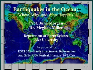
1. Earthquakes in the Ocean: Where, Why, and What Happens? As prepared for ESCI 323 - Earth Structure & Deformation And Sally Ride Festival , Houston (10/25/06) Prof. Julia Morgan Dr. Meghan Miller Department of Earth Science Rice University
31. Toe of Muroto Transect Decollement 1 km Proto-decollement Deformation front Proto- thrusts Frontal thrusts NANKAI TROUGH NANKAI PRISM PROTO-THRUST ZONE Depth (m) Trench Fill turbidites Shikoku Basin Strata hemipelagic sediments Ocean Crust
32.
33.
34.
35.
Editor's Notes
Add JOI and ODP logos, and Rice logo. And thanks for JOI,USSSP, etc.
The fourth, and perhaps the richest of the data maps, shows the topography and bathymetry of the Earth. This is the elevation of the land surface and the depth of the oceans. The map uses color to indicate varying elevation and depth and simulates sun shading to add a sense of 3-dimensionality to the map. The scale bar on the right shows how colors on the map correspond to elevation in meters.
An exercise based on observing, describing, and classifying data must be built on some rich and well displayed data. I use 4 data maps that contain an amazing amount of information about large scale plate tectonic processes on the Earth. These data have been acquired over many years by many scientists. When examined together, most of the basic tenets of plate tectonics are laid bare and seem irrefutable. Scientists developing the key ideas of plate tectonics over the past 40 years had only fragments of these data to work with as they tried to describe, classify, and interpret what they saw. In Discovering Plate Boundaries, you will be asking your students to walk the same path, but with the advantage of more complete, although not perfect, data. The first map shows earthquake locations and depths. The location of each earthquake is indicated by a small dot and its depth is indicated by the color of the dot. Red dots indicate earthquakes having depths between zero and 33 km. We refer to these as shallow earthquakes. The yellow or orange dots indicate earthquakes having depths between 33 and 70 km. We call these intermediate depth earthquakes. The green dots indicate earthquakes having depths between 70 and 300 km We call these deep earthquakes. The blue dots indicate earthquakes having depths between 300 and 700 km. We call these ultra-deep earthquakes.
The second map shows the locations of recent volcanic or thermal features on the Earth. In this dataset, recent refers to the past 10,000 years. The dots represent volcanoes, geysers, hot springs, and similar features. In these slides, the maps are not shown in a way that you can see all the detail. The second part of the Teachers Guide, called A Tour of the Maps, shows the maps in much more detail. It is also possible to download the maps in several high resolution formats from the DPB website so that you can see the details.
The third map shows the age of the oceanic crust under most of the world’s oceans. This map really highlights divergent plate boundaries, also known as mid-ocean ridges or spreading centers. The scale bar on the right shows how the colors correspond to age of the seafloor in millions of years. Red signifies the youngest crust. Blue signifies the oldest known oceanic crust. An important feature of the maps used in this exercise is that they are all displayed at the same scale and projection, and use the same coastline data. Uniformity of the map base makes it easy for students to compare data from map to map. This is an important aspect of the exercise. It is possible to obtain excellent maps (better than mine!) of each of these data from other sources, but they are unlikely to be displayed in the same way. I have found inconsistent display to be a source of frustration for students.
The fourth, and perhaps the richest of the data maps, shows the topography and bathymetry of the Earth. This is the elevation of the land surface and the depth of the oceans. The map uses color to indicate varying elevation and depth and simulates sun shading to add a sense of 3-dimensionality to the map. The scale bar on the right shows how colors on the map correspond to elevation in meters.
When the students arrive for the first period of the class, I hand out the Student Instruction sheet, and a plate boundary map. I use 11 by 17 in black and white maps that I make on a copying machine. They are displayed at the same projection and base as the data maps, although to a smaller scale. I also hand each student a slip of paper with a Scientific specialty (Seismology, Geochronology, Volcanology, or Geography) and a Plate Name (Pacific Plate, North American Plate, African Plate, and etc.). My goal is to have each student have a different combination of specialty and plate, and for all four scientific specialties to be covered for each plate used in the exercise. Therefore, if you have 24 students, I would use 6 plates and have all four specialties for each. Numbers that are not multiples of four can be handled by having 1-3 plates with only 3 specialties. If I have to do this, I drop a different specialty from each, but never Seismology. I bet you can guess that I am a Seismologist! I mix the specialties and plates up randomly among students because I think this exercise works best if they are not self arranged into their usual social groupings.
The fourth, and perhaps the richest of the data maps, shows the topography and bathymetry of the Earth. This is the elevation of the land surface and the depth of the oceans. The map uses color to indicate varying elevation and depth and simulates sun shading to add a sense of 3-dimensionality to the map. The scale bar on the right shows how colors on the map correspond to elevation in meters.
![Dale Sawyer’s Discovering Plate Boundaries Exercise (http://terra.rice.edu/plateboundary) ,[object Object],[object Object],[object Object],[object Object],An aside:](data:image/gif;base64,R0lGODlhAQABAIAAAAAAAP///yH5BAEAAAAALAAAAAABAAEAAAIBRAA7)