Download to read offline

![ Extensive iron deposits formed in shallow Proterozoic
seas, indicating there was enough free oxygen to
precipitate iron oxide minerals (for example,
hematite [Fe 2O 3]) from the iron in the water. The
increase in the amount of free oxygen is thought to
be a result of photosynthetic action by primitive life
forms in the sea. The fossil record has preserved
layered algal mounds called stromatolites, an
abundance of microscopic species, and trails and
burrows from wormlike organisms.](https://image.slidesharecdn.com/aaaearthquakeengineering-150715145759-lva1-app6892/85/Aaa-earthquake-engineering2-13-320.jpg)


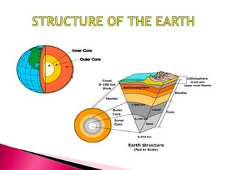
The document summarizes key information about the structure and composition of the Earth. It describes the three main layers - the core, mantle, and crust. The core has a solid inner core and liquid outer core made of iron and nickel. The mantle is the largest layer and mainly composed of silicate minerals. It is divided into the rigid lithosphere and soft asthenosphere. The crust is the thin outer layer composed of different rock types and containing all life.


