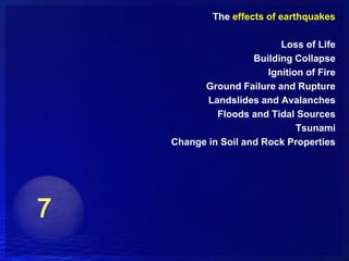
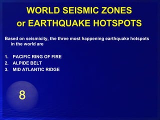
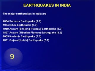
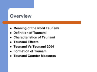
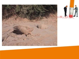
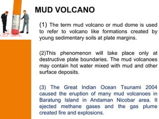
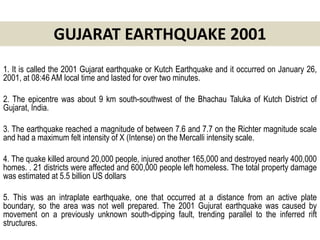
This document provides an overview of seismicity and earthquakes. It discusses seismic waves, earthquakes and faults, measures of earthquakes including magnitude and intensity, ground damage from earthquakes, tsunamis caused by earthquakes, and earthquake resistant construction. Specific topics covered include the 2001 Gujarat earthquake in India and the devastating 2004 Indian Ocean tsunami. The document aims to introduce students to key concepts regarding seismicity and earthquakes.
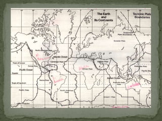
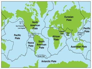
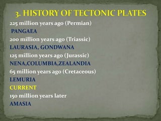
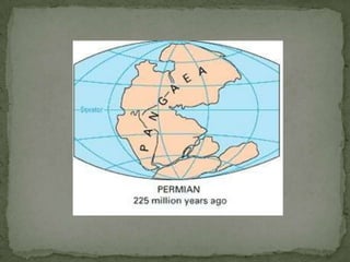
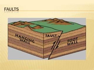
This document discusses various seismic hazards caused by earthquakes, including primary hazards like ground shaking and secondary hazards like fires. It describes how ground conditions can amplify or attenuate ground shaking. It also discusses liquefaction and landslides that earthquakes can trigger. The document covers challenges with earthquake forecasting given limitations in historical earthquake data, and explains the concept of seismic gaps.
There are many different means of investigating the landslide-prone areas. Two types of landslide hazard evaluation methods are available. One is the direct observation and the other one is the use of technological tools. One of the guiding principles of geology is that the past is the key to the future. In evaluating landslide hazards, the future slope failures could occur as a result of the same geologic, geomorphic, and hydrologic situations that led to past and present failures. Based on this assumption, it is possible to estimate the types, frequency of occurrence, extent, and consequences of slope failures that may occur in the future. A landslide susceptibility map goes beyond an inventory map and depicts areas that have the potential for landsliding.
UNIT-V Slope Stability - Land Slides.pptmythili spd
This document provides information on landslides, slope stability, retaining structures, and major disasters in India. It defines landslides as permanent downward and outward movements of soil and rock under gravitational forces. Slope stability is analyzed using factors of safety to determine if a slope is safe or unstable. Methods to stabilize slopes include regrading, drainage, incorporating structures, and loading the toe. Retaining structures help ensure slope stability but are difficult to construct on moving slopes. Major disasters in India include earthquakes, floods, droughts, and cyclones that have caused thousands of deaths and widespread damage.
MICRO-ZONING AND RISK MAPPING FOR DISASTER PREPAREDNESSEminent Planners
This document discusses disaster risk assessment and micro-zoning for preparedness. It defines key terms like risk, vulnerability, mitigation and preparedness. It describes how mitigation includes long-term measures to reduce risk, while preparedness consists of short-term activities. The document outlines the process of risk mapping, which involves combining hazard, exposure and vulnerability maps. It discusses approaches for mapping event intensity, exposure, and risk, as well as challenges in seismic hazard evaluation.
This document discusses the syllabus for a course on disaster management. It covers 5 units: definitions and types of disasters; case studies of important disasters; mitigation and management; safety processes; and planning and response. Unit 4 discusses coping strategies for disasters, changing concepts in disaster management, and industrial safety plans. It notes the importance of coping mechanisms, community involvement, and a developmental rather than emergency response approach to disasters. Industrial safety risks include fire, explosion, and toxic chemical releases.
Risk Analysis of Geological Hazards and Disaster ManagementClaudio Ferreira
This document discusses risk analysis of geological hazards and disaster management. It defines risk as the probability of hazard occurring multiplied by vulnerability and damage. Hazards are defined as the probability of a potentially damaging phenomenon occurring within an area and time period. The document outlines approaches to risk mapping including analytical and synthetic methods and the role of GIS systems. It also briefly mentions disaster management.
1. Mass wasting refers to the downslope movement of rock and soil due to gravity. It occurs on all slopes and can range from very slow to sudden movements.
2. The stability of a slope depends on a balance between the downward force of gravity and friction/shear strength resisting movement. Steeper slopes and saturated soils or rock are more prone to failures.
3. Common landslide types include rotational slumps and translational slides, which move along concave and planar surfaces, respectively. Earthquakes and rapid addition of water can also trigger landslides.
India is a country of Disasters. We are looking into Disaster Management as a basic problem of India. Our own work in the field of Earthquakes is also discussed.
1) The document summarizes the steps taken to perform a seismic hazard assessment of Khyber Pakhtunkhwa (KPK) province in Pakistan. These steps include compiling an earthquake catalog from various sources, homogenizing the magnitudes, de-clustering the catalog, performing completeness analysis, defining seismic zones, and developing Gutenberg-Richter recurrence models.
2) Shallow seismic zones were defined based on clustering of shallow earthquakes in the de-clustered catalog. Deep seismic zones were also identified based on deep earthquake locations.
3) Gutenberg-Richter recurrence models were developed for each seismic zone to obtain cumulative frequency of earthquakes per year needed for probabilistic seismic hazard analysis.
A description on the petroleum system of BangladeshShahadat Saimon
This document provides an overview of the petroleum system of the Bengal Basin, which covers Bangladesh and parts of India. It discusses the basin's geological setting, stratigraphy, tectonic evolution, and three petroleum provinces - the Eastern Fold Belt, Central Foredeep, and Northwestern Stable Shelf/Platform. The key points are:
- The Bengal Basin was formed during the breakup of Gondwanaland in the Cretaceous period.
- It has over 20km of sedimentary deposits and multiple petroleum systems in Miocene sands.
- The Eastern Fold Belt contains the majority of Bangladesh's gas fields in structures like anticlines.
- The Central Foredeep is also
This presentation discusses electrical resistivity methods for geophysical surveying. It describes how resistivity utilizes differences in electric potential to image the subsurface. Key concepts covered include Ohm's law, electrode configurations like Wenner and Schlumberger arrays, methods like vertical electrical sounding and electric profiling, and instrumentation used including current sources, resistivity meters, and electrode types. Applications mentioned are groundwater detection, mineral exploration, and waste exploration.
This document discusses different approaches to human ecology and their relation to disasters. It describes three main approaches: ecosystem approach, landscape approach, and perception approach.
The ecosystem approach focuses on biological organization and interactions between organisms and their environment. It recognizes humans as integral parts of ecosystems. The landscape approach takes an interdisciplinary view of both natural and human-built features, stakeholders, and external forces affecting an area. It facilitates inclusive risk assessment and planning.
The perception approach involves three stages - selection of information, organization of selected information into patterns based on proximity, similarity, or difference, and interpretation of organized information based on internal and external factors like personality, experience, and environmental cues.
The document provides an introduction to various coastal structures used for coastal protection. It describes sea dikes, sea walls, revetments, emergency protection, bulkheads, groynes, jetties, breakwaters, and detached breakwaters. Each coastal structure is defined and its applicability is discussed. The document categorizes coastal protection structures as coastal protection, shore protection, beach construction, management solutions, and sea defense. It aims to give an overview of different types of structures used to protect coasts from erosion, flooding, and damage from waves and currents.
This document discusses the role of remote sensing and GIS in disaster management. It begins with an introduction to disaster management cycles and then describes how remote sensing is used across different stages of disasters like cyclones, earthquakes, and floods for tasks such as early warning, damage assessment, and recovery planning. It provides examples of various satellites used for monitoring different disasters. The document emphasizes that while hazards cannot be prevented, remote sensing can play a key role in minimizing loss of life through preparedness, response, and rebuilding efforts after disasters strike.
Scientists aim to predict, protect from, and prepare for earthquakes by monitoring seismic activity, animal behavior, and structural changes. Effective preparation includes developing early warning systems, coordinating emergency response plans, and educating the public on safety precautions. Engineers design earthquake-resistant buildings using techniques like base isolation, bracing, and damping to minimize structural damage and risks to occupants.
This document provides an overview of glaciers, including their formation, movement, and important terminology. It describes the key parts of a glacier, including the accumulation and ablation zones. The document also discusses different types of glaciers and their varying speeds of movement. Finally, it covers the erosional and depositional landforms created by glaciers, such as moraines, eskers, and drumlins.
Seismic waves are energy propagated through the earth by earthquakes or artificial sources. There are two types of body waves (P and S waves) that travel through the earth and surface waves (Rayleigh and Love waves) that travel along the earth's surface. Seismic wave velocities depend on the elastic properties and density of the earth materials and are used to determine subsurface layering and structures. Analysis of travel times and slopes of seismic wave arrivals on record sections allows calculation of subsurface velocities and reflection/refraction of waves at interfaces between subsurface layers.
It superficially discusses the impact that urbanisation have on quality, quantity, recharge, and discharge of, water from subsurface aquifers, groundwater.
Microzonation of seismic hazards and their applicationArghya Chowdhury
What is Microzonation? How is Microzonation helpful in mitigating Seismic hazards and in civil engineering? Find out all about it in this Presentation.
The document discusses the lowstand systems tract (LST), defining it as deposits that accumulate after the onset of relative sea-level rise during a period of early rise and normal regression. The LST includes fluvial, coastal, shallow marine, and deep marine deposits characterized by progradation or retrogradation. Key points covered include the depositional processes and products of each environment within the LST, as well as the economic potential of LST deposits for reservoirs and placer deposits.
Introduction to natural hazard and disaster management Jahangir Alam
The document discusses natural hazards and disasters. It notes that the Earth experiences approximately 2,000 earth tremors and 2 earthquakes strong enough to cause damage daily. There are also around 1,800 active thunderstorms globally at any given time and 4-5 tornadoes per day. The document provides definitions of key terms like hazards, disasters, risk, and vulnerability. It explains that disasters occur at the intersection of hazards, vulnerability, and insufficient risk reduction measures. Disaster risk management aims to reduce risks through prevention, mitigation, preparedness, response, recovery and rehabilitation efforts.
The document discusses vulnerability in disaster management. Vulnerability is defined as characteristics determined by physical, social, economic and environmental factors that increase susceptibility to hazards. Vulnerability is affected by many factors and is a key part of understanding disaster risk. These factors include physical conditions, social and economic issues, and environmental influences. Assessing vulnerability involves understanding the underlying causes and people's ability to cope with and recover from disasters. Reducing vulnerability can be achieved through measures like building codes, insurance, economic diversity, and preparedness.
Glacial processes and their land forms.Pramoda Raj
Glaciers are masses of ice that move due to gravity. They erode the landscape through abrasion and plucking, and transport material large distances. Glaciers deposit this material as till or outwash. Glacial processes form characteristic landforms such as cirques, arêtes, and u-shaped valleys through erosion and landforms like moraines and eskers through deposition. Glacial lakes are also left behind when a glacier melts.
This document discusses sedimentary basins, including their definition, formation, and analysis. Key points:
- Sedimentary basins form in low areas of the crust where sediments accumulate due to tectonic activity that creates relief. They range in size from hundreds of meters to ocean basins.
- Tectonics is the primary control on sedimentation, affecting factors like sediment supply and depositional environment. Sedimentation also influences tectonics by increasing lithospheric loading.
- Basins can be formed by processes including faulting, thermal subsidence of extended lithosphere, and flexural subsidence caused by loading of the lithosphere.
- Analyzing features of sedimentary
The document summarizes a study that characterized the soil conditions at a residential development site in Istanbul, Turkey using engineering seismology techniques. Seismic refraction and reflection surveys were conducted to determine P-wave and S-wave velocity profiles down to 30 meters depth. Three sections with different soil properties were identified. Parameters for geotechnical earthquake engineering were estimated for each section, including maximum soil amplification, natural period of soil column, maximum surface to bedrock acceleration ratio, depth of significant acceleration, maximum soil-rock response, and design spectrum periods. These parameters will be used by engineers for soil classification and structural design.
Vs30 measurements for Seismic Site ClassificationAli Osman Öncel
This document summarizes standard penetration testing (SPT) and shear wave velocity profiling, which are important geotechnical investigation techniques for seismic design. SPT involves driving a split spoon sampler into the ground using a hammer and measuring penetration resistance. Shear wave velocity profiling uses borehole, suspension, and surface wave methods to directly measure in-situ shear wave velocities, which are used to classify seismic soil sites according to building codes. Proper site characterization that includes SPT and shear wave velocity data is essential for evaluating soil properties and predicting earthquake ground motions at a site.
The 2005 Kashmir earthquake occurred on October 8, 2005 near Muzaffarabad, Pakistan. It registered a magnitude of 7.6 and caused widespread destruction, killing over 86,000 people. The hardest hit areas were Pakistan-administered Kashmir, Khyber-Pakhtunkhwa, and parts of Indian-administered Kashmir. International aid poured into the region to assist relief efforts.
This document discusses how landforms are changed by movements of the Earth's crust. It introduces key concepts like tectonic plates, earthquakes, volcanoes, and different types of mountains. It explains that earthquakes occur when plates move and energy is released. Volcanoes form when magma is pushed up from below the surface and flows out, becoming lava. Different types of faults can cause mountains to form by crumpling and pushing up the crust. The document provides vocabulary related to these topics and models how volcanic eruptions and earthquakes change the shape of the land over time.
Architecture in kashmir rural & urban Hakim Danish
Kashmir has a humid climate with severe winters and mild summers. Rural buildings in Kashmir are constructed traditionally using local materials like stone, mud, bricks and wood. These vernacular buildings reflect the local culture and are optimized for the climate. They use thick stone and mud walls for insulation and pitched timber roofs to prevent snow accumulation. Urban areas have denser development with multi-story structures using timber frame construction like dhajji or brick masonry with timber bands called taaq. Traditional heating and cooking methods use efficient wood-burning stoves and water heaters built into walls.
The document discusses earthquakes and techniques for improving earthquake resistance in buildings. It defines earthquakes and describes how they occur due to movement in the earth's crust. It then covers types of earthquakes, causes and effects, seismic waves, and performance and design considerations for improving earthquake resistance. Specific techniques discussed include using shear walls, base isolation methods, energy dissipation devices, and keeping buildings in compression. The conclusion emphasizes following construction standards and periodic training to help assure earthquake-resistant buildings.
The presentation aiding the lecture Structure of Earth and its Composition for the course CE 8392 Engineering Geology handled by Prof. Rathnavel Pon for Akshaya College of Engineering and Technology, Coimbatore
Earth is composed of four main layers - crust, mantle, outer core, and inner core. The crust is the outermost layer and is made up of either continental or oceanic crust. Below the crust is the mantle, which is divided into lithosphere, asthenosphere, upper mantle, and lower mantle. The outer core is a liquid layer made of nickel and iron that generates Earth's magnetic field. The inner core is made of solid iron deep within Earth. Overall, Earth's composition is approximately 34.6% iron, 29.5% oxygen, and 15.2% silicon.
This document provides an overview of the internal structure of the Earth. It describes the three main layers - crust, mantle, and core. The crust is the outermost layer and is divided into continental and oceanic crust. Beneath the crust is the mantle, which makes up most of the Earth's volume. The core is at the center and has a solid inner core and liquid outer core. Seismic waves and magnetic reversals provide evidence about the composition and movement of materials in the Earth's interior.
This document provides an introduction to seismology. It discusses how seismology studies earthquakes and the propagation of energy through the Earth's crust. It then describes the formation of the Earth and its layers, including the crust, mantle, outer core, and inner core. It explains what causes earthquakes, such as the movement of tectonic plates and the rupture of rocks along faults. Finally, it discusses evidence that supported Alfred Wegener's theory of continental drift and how plate tectonics helps explain the distribution of earthquakes and volcanic activity at plate boundaries.
The document discusses the structure and layers of the Earth. It is composed of four main layers from outermost to innermost:
1) The crust, which is the thin solid outer layer people live on made of rocks and minerals. It is divided into thicker continental crust and thinner oceanic crust.
2) The hot, dense mantle that behaves like a solid but can flow very slowly over geologic timescales. Its convection currents influence plate tectonics at the surface.
3) The liquid outer core that is composed of melted nickel and iron due to extreme heat and pressure.
4) The inner solid core formed from compressed metals vibrating in place like a solid.
This document provides an overview of continental margins. It begins with introducing the objectives of understanding the importance and characteristics of continental margins in the context of earth and oceanographic studies. It then discusses various topics relevant to continental margins, including the earth's crust, plate tectonics, sea floor spreading, types of plate boundaries and movement, and features of convergent and divergent plate boundaries. The key aspects of continental margins are that they are the submerged zones separating thick continental crust from thin oceanic crust, and form the outer edges of continents.
The document discusses the structure and evolution of the Earth. It describes the Earth's interior as being composed of a crust, mantle, and core. The crust and upper mantle form tectonic plates that move over Earth's surface. Evidence for plate tectonics includes matching continental margins and the distribution of fossils, rocks, and glacial deposits across continents. The Earth formed over 4.6 billion years ago from a solar nebula. Life evolved around 3.8 billion years ago and photosynthesis emerged 2.5-3 billion years ago. The atmosphere and climate have changed over geological eras from the Archean to present day.
The document provides an overview of the structure and composition of the Earth's layers, including the crust, mantle, and core. It then discusses plate tectonics and evidence that supports the theory of continental drift, such as matching geological formations and fossil distributions between continents before they drifted apart. The development of the modern theory of plate tectonics to explain continental movement is also outlined.
Ophiolites provide evidence for the composition and structure of oceanic crust and the upper mantle. They represent sections of oceanic crust and upper mantle that have been obducted or thrust onto continental margins. Studying ophiolites like the Samail ophiolite in Oman has helped scientists understand the layered sequence of rocks that make up oceanic crust, including extrusive basalts, dikes, and intrusive gabbros.
This document provides information about plate tectonics and is designed to meet South Carolina science standards. It discusses the layers of the Earth, tectonic plates and their movement, and the three types of plate boundaries - convergent where plates collide, divergent where they separate, and transform where they slide past each other. Specific examples are given for each boundary type, including discussions of sea floor spreading at mid-ocean ridges, subduction zones creating volcanoes and trenches, and the San Andreas Fault as a transform boundary.
- The document discusses models of Earth's structure, including the static (geochemical) model and dynamic (geodynamic) model. The static model divides Earth into layers based on chemical composition, while the dynamic model considers physical state and mechanical properties.
- Plate tectonics theory holds that Earth's lithosphere is divided into plates that move over the asthenosphere. Plates can converge at boundaries, causing one to subduct under the other, or diverge such as at mid-ocean ridges.
- Evidence for continental drift includes matching continental margins, matching geological formations and fossil distributions across continents, and paleoclimate and paleontological indicators matching when the continents were joined in the past.
Geological oceanography involves the study of the structure and history of the ocean floor through various investigations. It examines features such as the continental shelf, trenches, and ridges on the ocean floor and surrounding coastal areas. The physiography of the Bay of Bengal is also described, noting its triangular shape, surrounding countries, and various underwater topographic features like ridges and trenches. Brief histories of marine geology and the development of the geologic time scale are also provided.
WHAT IS A PLATE? MAJOR PLATES. Types of Earth’s Crust. Plate BoundaryUday Kumar Shil
The document discusses plate tectonics and the key concepts of plate tectonic theory. It describes how the lithosphere is broken into large plates that move over Earth's surface, driven by convection currents in the underlying mantle. It outlines the three main types of plate boundaries - divergent boundaries where new crust forms, transform boundaries where plates slide past each other, and convergent boundaries where plates collide and one slides under the other. It also discusses the evidence that supported the development of plate tectonic theory, such as seafloor spreading and magnetic reversals recorded in oceanic crust.
The document discusses the causes and types of earthquakes. It begins by noting that records of earthquakes date back thousands of years in some areas. It then explains that earthquakes are caused by the sudden movement of tectonic plates deep below the earth's surface. The major types of plate boundaries are divergent boundaries where new crust forms, convergent boundaries where plates collide and crust is destroyed, and transform boundaries where plates slide past each other. Specific examples like the Mariana Trench and San Andreas Fault are also described.
The document summarizes information about the Earth, including its interior structure, tectonic plates, continents, and earthquakes and volcanoes. It describes the lithosphere and two types of crust. It explains tectonic plates and lists the seven major plates. It discusses continental drift and the movement of continents over time. It provides brief descriptions of volcanoes and earthquakes, including what causes them and examples of volcanic eruptions and earthquake damage.
2013 updated plate tectonics new one use this oneharvey09
The document summarizes plate tectonics and the development of the theory. It describes how early scientists like Wegener proposed continental drift but lacked evidence. Later, mapping of the ocean floor revealed patterns of magnetic stripes and rock ages indicating the seafloor spreads from mid-ocean ridges. This led scientists in the 1960s to develop the modern theory of plate tectonics, which proposes that Earth's crust is divided into plates that move due to convection currents in the mantle.
The document provides information about studying the Earth's interior. It discusses the different layers of the Earth (crust, mantle, outer core, inner core) and their compositions. Key points include:
- Seismic waves like P waves and S waves are used to determine the layers and their properties by measuring how fast they travel.
- Discontinuities like the Mohorovičić discontinuity and Gutenberg discontinuity indicate changes in density between layers.
- The outer core is liquid while the inner core is solid based on how seismic waves propagate.
The document summarizes key aspects of the Earth's formation and structure. It describes how the Earth formed from meteorites millions of years ago. It then details the development of the moon through a collision with Mars. It also outlines the Earth's rotation, which causes day and night, and its revolution around the sun, which causes seasons. Finally, it provides an overview of the Earth's layered structure, including the inner and outer core, mantle, crust, and how tectonic plates shape the continents.
This is the entire CSEC geography syllabus (some things might be missing). The information was collected from various websites and textbooks. The topics are:
- Internal forces
-External forces
-Rivers
-Limestone
-Coasts
-Coral reefs and Mangroves
-Weather and Climate
- Ecosystems (vegetation and soils)
-Natural hazards
- Urbanization
-Economic activity
-Environmental degradation
The presentation aiding the lecture Fundamentals of Geology for the course CE 8392 Engineering Geology handled by Prof. Rathnavel Pon for Akshaya College of Engineering and Technology, Coimbatore
This document provides an overview of smart cities in India and Coimbatore's participation in the Smart Cities Mission. It defines urban development in India, outlines past urban development programs like JNNURM and AMRUT, and describes the goals and components of a smart city. It then details India's Smart Cities Mission, including the selection process for cities and financing mechanisms. The document concludes by outlining Coimbatore's selected projects worth over Rs. 1000 crores to improve infrastructure like roads, housing, energy access and lake development, as well as deploy smart solutions for lighting, surveillance and more.
Sustainable concrete uses less energy and produces fewer carbon emissions than regular concrete. It incorporates waste and recycled materials like fly ash and slag to replace portions of cement. Using these supplementary cementitious materials can increase sustainability by reducing embodied energy and carbon in the concrete. Sustainable strategies also include minimizing water use, using local and recycled aggregates, and designing for durability to lessen environmental impacts over the concrete's lifetime. The presentation outlined various approaches to sustainable concrete and its advantages in promoting greener construction.
This document discusses the importance of teamwork. It is divided into sections about building an effective team, the different types of team members, stages of team development, and qualities that make teams successful. Examples are provided to illustrate key points, such as the importance of shared goals and roles, overcoming challenges together, and pride in team accomplishments. The document emphasizes that teamwork allows a group of people to achieve more together than any individual could alone.
The document provides an introduction to the Rotaractors club of GRD CAS, outlining what a Rotaractors club is, the benefits of joining, and the types of activities and services they are involved in including club services, community services, professional and vocational services, and international services. It also describes the structure of the club including board members, annual planning and budgeting, district and international involvement, and support available from the district Rotaract council and partner Rotary club.
The document contains a series of lines with names of people followed by short descriptors. However, the names and descriptors are random and do not seem to be meaningfully connected to each other. It is difficult to extract any clear overall meaning or to summarize the content in just a few sentences as the document appears to be nonsense text.
The document provides an overview of fundamentals of engineering graphics including drawing instruments, drawing sheets, computer aided drafting and modelling, and drawing processes. It discusses various methods of technical drawing including freehand sketching, manual drafting, and computer aided drafting. Key aspects covered are drawing instruments, types of drawing sheets, software and hardware used for computer aided drafting and modelling, and common drawing processes such as layout, line types, lettering, dimensioning, and scale.
This document provides an overview of astronomical surveying concepts. It discusses the celestial sphere model used to depict celestial objects, important astronomical terms like right ascension and declination, and the motions of celestial bodies like the Sun, stars, and planets. It also covers different coordinate systems used in astronomy like the altitude-azimuth and equatorial systems. Finally, it briefly introduces various time systems used, such as sidereal, mean, and standard times.
The document discusses tectonic plates and plate tectonics. It defines tectonic plates as large slabs or blocks of the lithosphere that are divided into major and minor plates. The major plates include the African, Antarctic, Eurasian, Indo-Australian, North American, Pacific, and South American plates. The document provides examples of divergent, convergent and transform plate boundaries and their associated geological features. It also summarizes the evidence for continental drift and the past configurations of the continents over geologic time.
The document discusses earthquakes, including their causes, measurement, effects, and zones of risk. Some key points:
- Earthquakes are caused by movement of tectonic plates and faults in rocks. Their magnitude is measured on the Richter Scale and their intensity by the Mercalli scale.
- Seismic waves transmit earthquake energy and are used to locate epicenters. The major earthquake zones are the Pacific Ring of Fire, Alpide Belt, and Mid-Atlantic Ridge.
- India has five seismic zones of risk. Zone V including Kashmir and Northeast India faces the highest risk, while Zone I including parts of central India faces the lowest risk.
Faults are cracks or fractures in the Earth's crust caused by stresses that induce brittle deformation of rocks. There are three main types of faults: dip-slip faults which involve vertical motion, strike-slip faults with horizontal motion, and oblique-slip faults with an oblique motion. Normal faults occur during extension while reverse faults are caused by compression. The elastic rebound theory explains that tectonic plates accumulate energy during periods of stress until a sudden slip occurs along the fault, releasing energy in the form of seismic waves and causing earthquakes.
The first class where the students and teacher got to know about each other. It really broke a lot of ice and set the tone for a cordial classroom climate
This document outlines an introductory geology course for civil engineering students. It introduces geology and explains why it is important for students to learn. The document then outlines the course syllabus which covers 5 units on topics like mineralogy, petrology, structural geology, and geological investigations for civil engineering projects. It also provides the lesson plan, names course captains, and describes the evaluation scheme which includes internal and external assessments.
The document discusses various types of curves that are important in engineering applications. It covers conic sections like ellipses, parabolas and hyperbolas. It also discusses roulettes like cycloids and trochoids that are generated by a point on a moving circle. Involutes, which are curves traced by a point unwinding from a circle, are also covered. Examples are provided of how these curves are used in civil, mechanical and electrical engineering applications.
How to Add Chatter in the odoo 17 ERP ModuleCeline George
In Odoo, the chatter is like a chat tool that helps you work together on records. You can leave notes and track things, making it easier to talk with your team and partners. Inside chatter, all communication history, activity, and changes will be displayed.
it describes the bony anatomy including the femoral head , acetabulum, labrum . also discusses the capsule , ligaments . muscle that act on the hip joint and the range of motion are outlined. factors affecting hip joint stability and weight transmission through the joint are summarized.
বাংলাদেশের অর্থনৈতিক সমীক্ষা ২০২৪ [Bangladesh Economic Review 2024 Bangla.pdf] কম্পিউটার , ট্যাব ও স্মার্ট ফোন ভার্সন সহ সম্পূর্ণ বাংলা ই-বুক বা pdf বই " সুচিপত্র ...বুকমার্ক মেনু 🔖 ও হাইপার লিংক মেনু 📝👆 যুক্ত ..
আমাদের সবার জন্য খুব খুব গুরুত্বপূর্ণ একটি বই ..বিসিএস, ব্যাংক, ইউনিভার্সিটি ভর্তি ও যে কোন প্রতিযোগিতা মূলক পরীক্ষার জন্য এর খুব ইম্পরট্যান্ট একটি বিষয় ...তাছাড়া বাংলাদেশের সাম্প্রতিক যে কোন ডাটা বা তথ্য এই বইতে পাবেন ...
তাই একজন নাগরিক হিসাবে এই তথ্য গুলো আপনার জানা প্রয়োজন ...।
বিসিএস ও ব্যাংক এর লিখিত পরীক্ষা ...+এছাড়া মাধ্যমিক ও উচ্চমাধ্যমিকের স্টুডেন্টদের জন্য অনেক কাজে আসবে ...
Biological screening of herbal drugs: Introduction and Need for
Phyto-Pharmacological Screening, New Strategies for evaluating
Natural Products, In vitro evaluation techniques for Antioxidants, Antimicrobial and Anticancer drugs. In vivo evaluation techniques
for Anti-inflammatory, Antiulcer, Anticancer, Wound healing, Antidiabetic, Hepatoprotective, Cardio protective, Diuretics and
Antifertility, Toxicity studies as per OECD guidelines
Executive Directors Chat Leveraging AI for Diversity, Equity, and InclusionTechSoup
Let’s explore the intersection of technology and equity in the final session of our DEI series. Discover how AI tools, like ChatGPT, can be used to support and enhance your nonprofit's DEI initiatives. Participants will gain insights into practical AI applications and get tips for leveraging technology to advance their DEI goals.
Exploiting Artificial Intelligence for Empowering Researchers and Faculty, In...Dr. Vinod Kumar Kanvaria
Exploiting Artificial Intelligence for Empowering Researchers and Faculty,
International FDP on Fundamentals of Research in Social Sciences
at Integral University, Lucknow, 06.06.2024
By Dr. Vinod Kumar Kanvaria
Main Java[All of the Base Concepts}.docxadhitya5119
This is part 1 of my Java Learning Journey. This Contains Custom methods, classes, constructors, packages, multithreading , try- catch block, finally block and more.
A Strategic Approach: GenAI in EducationPeter Windle
Artificial Intelligence (AI) technologies such as Generative AI, Image Generators and Large Language Models have had a dramatic impact on teaching, learning and assessment over the past 18 months. The most immediate threat AI posed was to Academic Integrity with Higher Education Institutes (HEIs) focusing their efforts on combating the use of GenAI in assessment. Guidelines were developed for staff and students, policies put in place too. Innovative educators have forged paths in the use of Generative AI for teaching, learning and assessments leading to pockets of transformation springing up across HEIs, often with little or no top-down guidance, support or direction.
This Gasta posits a strategic approach to integrating AI into HEIs to prepare staff, students and the curriculum for an evolving world and workplace. We will highlight the advantages of working with these technologies beyond the realm of teaching, learning and assessment by considering prompt engineering skills, industry impact, curriculum changes, and the need for staff upskilling. In contrast, not engaging strategically with Generative AI poses risks, including falling behind peers, missed opportunities and failing to ensure our graduates remain employable. The rapid evolution of AI technologies necessitates a proactive and strategic approach if we are to remain relevant.
Introduction to AI for Nonprofits with Tapp NetworkTechSoup
Dive into the world of AI! Experts Jon Hill and Tareq Monaur will guide you through AI's role in enhancing nonprofit websites and basic marketing strategies, making it easy to understand and apply.
1. UNIT FIVE: SEISMICITY
As per the Syllabus According to our Omnibus
Seismic waves Introduction to Earth
Earthquakes and faults Tectonic Plates
Measures of an earthquake - Faults
magnitude & intensity Fundamentals of Earthquakes
Ground damage Earthquakes and Tsunamis
Tsunamis and earthquakes Ground Damage and Failure
Earthquake Resistant Design and
Construction
The Great Indian Ocean Tsunami, 2004
Gujarat Earthquake, 2001
3. SOME FACTS ABOUT THE EARTH
Earth is the only planet to be named in English. The
word ‘Earth’ is Old English word for "land“
Earth belongs to the Milky Way Galaxy, Local Group
Cluster and Virgo Super Cluster
Earth is the only planet to sustain life
Earth is believed to be existent for 450 million years
& evidences are from 225 million years
5. SOME FACTS ABOUT THE EARTH
Earth is the third planet from the sun
Earth is the fifth largest planet in the universe
The distance of the earth from the sun is 149,600,000 km
The diameter of the sun is 100 times the diameter of the
earth
The mass of the earth is 5.972 x 1024 kg
The Surface area of earth is 510,072,000 km²
6. SOME FACTS ABOUT THE EARTH
Before 500 BC, people thought that earth was flat. But
thanks to scientists like Aristotle and Pythagoras, people
know that the shape of the earth is spherical. However Sir
Isaac Newton showed that the earth was not a perfect
sphere, but a compressed spheroid.
The correct technical term to use will be oblate spheroid, a
type of ellipsoid solid formed when an ellipse is rotated
about its minor axis.
The study of size and shape of earth is called geodesy.
The diameter of earth at poles is 12715 km (minor axis)
The diameter of earth at equator is 12763 km (major axis)
7. STRUCTURE OF EARTH
The structure of earth (also
referred as cross–section) is
divided into mainly four layers
namely Crust, Mantle, Inner
Core and Outer Core.
9. STRUCTURE OF EARTH
CRUST
The outermost layer of the Earth is the crust. It is also the surface of the earth.
This comprises the continents and ocean basins and therefore it has been
classified into continental crust and oceanic crust.
The oceanic crust extends up to a distance of 0-10 kms (5-12 taken as
average) whereas the continental crust would extend up to 0-75 kms (20-70
taken as average).
The oceanic crust is mainly composed of basaltic igneous rocks, mainly of
silica and magnesium and therefore also called SIMA layer.
The continental crust is composed of crystalline and granitic rocks mainly of
silica and aluminum and therefore also called SIAL layer.
10. STRUCTURE OF EARTH
MANTLE
The next layer is the mantle, which is composed mainly of iron and
magnesium silicates. It is been referred as FeMa layer.
Mantle is also where most of the internal heat of the Earth is located. It is
about 2900 km thick.
It can be subdivided into four layers namely
(1) Lithosphere (70 – 100 kms)
(2) Asthenosphere (100 - 350 kms)
(3) Upper Mantle (350 – 670 kms)
(4) Lower Mantle (670 – 2900 kms)
Mohorovičić discontinuity, usually referred to as the Moho is the transition
boundary between the Earth's crust and the mantle.
11. STRUCTURE OF EARTH
MANTLE
The lithosphere is the outermost part of the mantle immediately below the
Mohorovičić discontinuity. It has a part of the tectonic plates that cover
surface of Earth.
Asthenosphere is a low seismic velocity zone where rocks are at or near
melting point. It also has a part of tectonic plates.
The lower mantle is probably mostly silicon, magnesium and oxygen
with some iron, calcium and aluminum.
The upper mantle is made up of mostly olivine and pyroxene
(iron/magnesium silicates), calcium and aluminum
12. STRUCTURE OF EARTH
OUTER CORE
The third layer is outer core. The outer core is a hot and liquid layer
comprising mainly of Nickel and (liquid) Iron. Therefore it is referred as NiFe
Layer.
The outer core may also contain lighter elements such as Si, S, C, or O.
The outer core ranges from 2900 kms to 5150 kms and is 2300 km thick.
The Earth's magnetic field is believed to be controlled by the liquid outer
core. It is also believed to be the responsible force of earth’s rotation and
electric currents.
The transition space between outer core and mantle is called Gutenberg
discontinuity
13. STRUCTURE OF EARTH
INNER CORE
The fourth layer is inner core.
This layer stretches from 5150km to 6370 km and is nearly 1200 km
thick.
The inner core is mostly made of solid iron and has little amounts of
nickel.
It is unattached to the mantle and is suspended in the molten outer core.
The inner core is believed to have the extreme temperature and pressure
conditions.
The transition region between outer core and inner core is called Lehmann
discontinuity
14.
15. What is tectonic plates?
What are the different tectonic plates?
What is the history of tectonic plates?
Do the tectonic plates move?
Briefly explain the movement of plates?
What is continental drift?
What is the evidence of tectonic plate movement?
How do tectonic plates cause earthquakes?
What are intraplate and interplate earthquakes?
16. The lithosphere is divided into several slabs or
blocks or plates. These plates are supported from
below by Asthenosphere. These plates are called
Lithosphere plates or Tectonic Plates.
Some of these plates encompass continents, some
of these plates encompass oceans and some of the
plates encompass both oceans and continents.
17.
18. The plates are divided into three categories
Primary Plates
Secondary Plates
Tertiary Plates
The primary plates and secondary plates are together
called major plates.
The tertiary plates are sub divisions of Primary and
Secondary Plates
19. Primary
African Plate
Antarctic Plate
Eurasian Plate
Indo-Australian Plate (sometimes Indian and Australian)
North American Plate
Pacific Plate
South American Plate
Secondary
Arabian Plate
Caribbean Plate
Cocos Plate
Juan de Fuca Plate
Nazca Plate
Philippine Sea Plate
Scotia Plate
20.
21.
22.
23. 225 million years ago (Permian)
PANGAEA
200 million years ago (Triassic)
LAURASIA, GONDWANA
125 million years ago (Jurassic)
NENA,COLUMBIA,ZEALANDIA
65 million years ago (Cretaceous)
LEMURIA
CURRENT
150 million years later
AMASIA
31. The movement of tectonic plates is believed to be induced
by the asthenosphere which induces heat and convection
currents.
The plates are capable of drifting with respect to each other
along their plate boundaries.
Based on the plate movement, there are 3 principal type of
boundaries namely
Diverging Boundaries
Converging Boundaries
Transform Boundaries
36. EXAMPLES
Divergent Boundaries
North American Plate & Eurasian Plate
Convergent Boundaries
South American Plate & Nazca Plate
Transform Boundaries
North American Plate & Pacific Plate near the JDF Plate
37.
38. PLEASE NOTE
When two continental plates diverge, a rift is created.
Eg. East African Rift
When two oceanic plates diverge, a ridge is created. Sea
Floor Spreading is said to occur.
Eg. Mid Atlantic Ridge
When two oceanic plates converge, an island arc and
trench are created.
When an oceanic and convergent plate converge, a volcano
and trench are created.
When two continental plates converge, a mountain range is
formed.
39. PLEASE NOTE
When two continental plates or oceanic plates or
continental/oceanic plates transform, EARTHQUAKE
HAPPENS
If one plate is trying to move past
the other, they will be locked until
sufficient stress builds up to cause
the plates to slip relative to each
other. The slipping process creates
an earthquake .
40. 6. WHAT IS CONTINENTAL DRIFT?
The movement of earth’s continents with respect to each
other due to the movement of tectonic plates is called
continental drift.
41. 7. EVIDENCES FOR
TECTONIC PLATE MOVEMENT
SIMILAR PLANT & ANIMAL FOSSILS IN CONTINENTS
SIMILAR LIVING ORGANISMS
SIMILAR ROCK TYPES ON CONTINENTS
COMPLEMENTARY ARRANGEMENT OF FACING SIDES OF SOUTH
AMERICA & AFRICA
SEAFLOOR SPREADING DATA
42. 8. INTRAPLATE & INTERPLATE EARTHQUAKES
1. An intraplate earthquake is an earthquake that occurs in the
interior of a tectonic plate, whereas an interplate earthquake is one
that occurs at a plate boundary or a plate margin.
2. Intraplate earthquakes are very rare whereas interplate
earthquakes are quite normal. The recurrence interval of intraplate
earthquake is 10 – 30 years while that of interplate earthquakes is
100 – 1000 years.
3. The effect (magnitude and intensity) of intraplate earthquakes is
less when compared with interplate earthquakes.
4. Notable examples of damaging intraplate earthquakes are the
devastating Gujarat earthquake in 2001 while that for interplate
earthquakes are Chile 1960 Earthquake and
44. THE TWO MOST IMPORTANT REASONS FOR
EARTHQUAKES
1. TECTONIC PLATES
2. FAULTS
45. FAULTS
FAULTS ARE ONE OF THE STRUCTURAL
FEATURES OF ROCKS
WHILE ROCKS AT OR NEAR THE
SURFACE OF THE EARTH ARE COOL &
BRITTLE, ROCKS BELOW THE SURFACE
OF THE EARTH ARE HOT AND TEND TO
MOVE
46. FAULTS
A LOT OF EXTERNAL FORCES ACT UPON
THE ROCKS AND CAUSE STRESS ON THEM
DUE TO THIS STRESSES, ROCKS EITHER
UNDERGO DUCTILE DEFORMATION(BEND)
OR BRITTLE DEFORMATION(BREAK)
IF THEY UNDERGO DUCTILE
DEFORMATION, ROCKS DEVELOP FOLDS.
IF THEY UNDERGO BRITTLE
DEFORMATION, THEY DEVELOP FAULTS.
48. FAULTS
FAULT IS DEFINED AS A SPLIT OR CRACK
OR FRACRTURE IN THE ROCK PRESENT IN
EARTH’S CRUST CHARACTERISED BY
RELATIVE DISPLACEMENT OF ONE SIDE
OVER THE OTHER.
The two sides of a non-vertical fault are known
as the hanging wall and footwall. By definition,
the hanging wall occurs above the fault plane
and the footwall occurs below the fault
54. DIP SLIP FAULTS
A fault where the relative movement on the
fault plane is approximately vertical is known
as a dip-slip fault.
Dip Slip Faults are divided into
Normal Faults (Extension)
Reverse Faults/Thrust Faults (Compression)
57. DIP SLIP FAULTS
When the hanging wall moves down with
respect to the footwall, it is called a normal
fault.
When the hanging wall moves up relative to
the footwall, it is called a reverse fault
58. STRIKE SLIP FAULTS
A fault where the relative movement on the
fault plane is approximately vertical is known
as a strike-slip fault.
Strike Slip Faults are divided into
Left Lateral Faults (Sinistral Faults)
Right Lateral (Dextral Faults)
61. STRIKE SLIP FAULTS
If you stand on one side of a fault and the other
side slips to the right, then it is called a right-
lateral fault.
In a left-lateral fault, the movement occurs to
your left.
65. FAULTS & EARTHQUAKES
FAULTS CAN CAUSE TREMENDOUS
EARTHQUAKES
STRIKE SLIP FAULTS CAUSE MAJOR
EARTHQUAKES WHILE OBLIQUE SLIP
FAULTS AND DIP SLIP FAULTS CAUSE
MINOR EARTHQUAKES.
THE OCCURRENCE OF EARTHQUAKES
DUE TO FAULTS IS EXPLAINED BY ELASTIC
REBOUND THEORY.
68. ELASTIC REBOUND THEORY
The elastic rebound theory is an explanation
for how energy is spread during earthquakes.
As plates on opposite sides of a fault are
subjected to force and shift, they accumulate
energy and slowly deform until their internal
strength is exceeded. At that time, a sudden
movement occurs along the fault, releasing
the accumulated energy, and the rocks snap
back to their original undeformed shape.
70. CONTENTS
1. DEFINITION OF AN EARTHQUAKE
2. EARTHQUAKES & SEISMICS
3. CENTRES AND SHOCKS
4. INTENSITY AND MAGNITUDE OF EARTHQUAKES
5. CAUSES OF EARTHQUAKE
6. SEISMIC WAVES
7. EFFECT OF EARTHQUAKES
8. WORLD SEISMIC ZONES
9. SEISMIC ZONES OF INDIA
71. Earthquake may simply expressed as a momentary
shock experienced by the earth at a particular location
and time.
Earthquake may be technically defined as the vibrations
induced in the earth’s crust due to internal or external
causes that give a shock to a part of the crust and all
things existing on it
72. The greek word for earthquake is
Seism and therefore the term seismic
is associated with earthquakes.
The science dealing with the study of
earthquakes is called seismology
The word seismic is used to qualify
anything related to earthquake such
as seismic intensity, seismic zoning,
seismic waves etc.
73. FOCUS OR HYPOCENTRE
The point of origin of an earthquake below the surface of earth.
EPICENTRE
The point on the surface directly above the focus where the vibrations
are felt.
74. SHOCKS
A large earthquake is generally preceded and followed by
many smaller shocks.
The largest earthquake is called the main shock. The
smaller ones that occur before the main shock are called
foreshocks and the shocks that occur after the main shock
are called aftershocks.
75. INTENSITY MAGNITUDE
Intensity is a term used to Magnitude is a term used
measure the impact of to establish the size of an
earthquake. earthquake.
Intensity measures the It is a measure of the
strength of shaking amplitude of a seismic
produced by the wave and is related to the
earthquake at a certain amount of energy released
location. during an earthquake.
Intensity is determined Magnitude is the total
from effects on energy released by an
people, human earthquake at its focus.
structures, and the natural
environment. The Richter Scale is most
famous to express the
Mercalli Scale was used magnitude of an
to predict intensity. earthquake.
76. INTENSITY AND MAGNITUDE
Magnitude and Intensity measure different
characteristics of earthquakes. Magnitude is quantitative
and measured using instrument called seismograph.
Intensity is qualitative and can be measured using
assessment of the damages.
78. MAGNITUDE
Magnitude is the logarithm to base 10 of maximum
amplitude traced on the seismogram by an instrument
placed at 100 km from the epicenter.
It can be generally calculated by the formula
M = log (A∆/Ao∆) where
M is Richter magnitude
∆ is epicentral distance
A is amplitude of the point to be measured
Ao is the maximum amplitude of zero earthquake
79. INTENSITY
Intensity is a space dependent descriptive rating of
changes observed to the ground surface in terms of
damaging effects. The damaging effects are ground
damage, damage to built environment and to the
humans. These effects are incorporated in a descriptive
intensity scale by a group of experts and denoted by
Roman numbers. Maximum intensity is usually close to
the epicenter and it reduces as the epicentral distance
increases. The lines of same intensity are plotted in a
contour map called isoseismal map which is a very
important data for earthquake analysis.
80. Nowadays intensity of earthquakes are not measured.
They have been replaced by magnitude.
Top 5 Earthquakes by Magnitude
S. Date Place Magnitude
No.
1 22 May 1960 Valdivia, Chile 9.5
2 27 March 1964 Alaska, USA 9.2
3 26 December Sumatra, Indonesia 9.1
2004
4 13 August 1862 Arica,Chile 9.0
5 26 January 1700 Cascadia, USA- 9.0
Canada
81. An earthquake may be caused by the following natural and artificial
sources.
NATURAL SOURCES
Tectonic Plates Movement 90%
Faults in Rocks (Elastic Rebound Theory) 6%
Volcanic Explosions 1%
ARTIFICIAL SOURCES
Explosion 1%
Mine Collapse 1%
Reservoir Failure 1%
82. SEISMIC WAVES
The energy released during earthquake travels to the
earth in form of waves.
The waves are called as
P-Waves
S-Waves
L-Waves (Rayleigh Waves & Love Waves)
P-Waves & S-Waves are called as body waves.
L- Waves are also called as surface waves.
83. The seismic waves are very useful as follows
They were used to establish the internal structure of the earth.
They are used to calculate the magnitude of earthquake. Richter
Scale is based upon the amplitude of the seismic waves.
They are also used to locate the epicenter of earthquakes.
They are also used for groundwater and other explorations.
84.
85. Primary, or P waves are the first waves felt during
an earthquake and they are the fastest.
They move in a compressional, "push-pull"
manner similar to a spring
They are longitudinal in character. They move
only in the direction of prorogation.
They temporarily change the volume of the
material they're moving through.
They can travel through liquid, solid and gaseous
matter.
Their velocity increases with depth and decreases
after the Gutenberg Discontinuity.
86. Secondary, or S waves, are felt next to P
waves.
These waves move in an
oscillatory/distortional manner similar
to shaking a rope.
They are transverse in character. They
move perpendicular to the direction of
prorogation.
They temporarily change the shape of
the material they're traveling through
They can travel through solids only.
Their velocity increases with depth and
they are absent beyond mantle.
87. L Waves or Long Waves or Surface
Waves are finally felt, are felt next
to S waves.
They are of two types namely – Love
Waves and Rayleigh Waves
Rayleigh Waves move in a complex
manner. They partly move in
direction of propagation and
partly perpendicular to the
direction of prorogation.
Love Waves move in the direction of
propagation horizontally but in
sideways.
It is only the Surface Waves cause
damage to the building.
88.
89.
90.
91. The effects of earthquakes
Loss of Life
Building Collapse
Ignition of Fire
Ground Failure and Rupture
Landslides and Avalanches
Floods and Tidal Sources
Tsunami
Change in Soil and Rock Properties
92. WORLD SEISMIC ZONES
or EARTHQUAKE HOTSPOTS
Based on seismicity, the three most happening earthquake hotspots
in the world are
1. PACIFIC RING OF FIRE
2. ALPIDE BELT
3. MID ATLANTIC RIDGE
93.
94.
95.
96. EARTHQUAKES IN INDIA
The major earthquakes in India are
2004 Sumatra Earthquake (9.1)
1934 Bihar Earthquake (8.7)
1950 Assam (Shillong Plateau) Earthquake (8.7)
1897 Assam (Tibetian Plateau) Earthquake (8.5)
2005 Kashmir Earthquake (7.6)
2001 Gujarat(Kutch) Earthquake (7.1)
98. EARTHQUAKE ZONES IN INDIA
There are five seismic zones named as I to V based on Modified Mercalli
Scale (MM Scale) as details given below:
Zone V: Covers the areas liable to seismic intensity IX and above on MM
Scale. This is the most severe seismic zone and is referred here as Very
High Damage Risk Zone.
Zone IV: Gives the area liable to MM VIII. This, zone is second in severity to
zone V. This is referred here as High Damage Risk Zone.
Zone III: The associated intensity is MM VII. This is termed here as
Moderate Damage Risk Zone.
Zone II: The probable intensity is MM VI. This zone is referred to as Low
Damage Risk Zone.
Zone I: Here the maximum intensity is estimated as MM V or less. This zone
is termed here as Very Low Damage Risk Zone.
99.
100.
101. EARTHQUAKE ZONES IN INDIA
Zone V: Kashmir, Punjab, the western and Central Himalayas, the North-
East Indian region and the Rann of Kutch fall in this zone.
Zone IV: Indo-Gangetic basin and the capital of the country(Delhi, Jammu)
and Bihar fall in Zone 4.
Zone III: The Andaman and Nicobar Islands, parts of Kashmir, Western
Himalayas, Western Ghats fall under this zone
Zone II: Other parts of India namely Hyderabad, Lakshadweep, Orissa etc.
Zone I : No
102. EARTHQUAKE ZONES IN INDIA
Cities and Zones
• Zone III :- Ahemdabad, Vadodara, Rajkot, Bhavnagar, Surat,Mumbai,
Agra, Bhiwandi, Nashik, Kanpur Pune, Bhubneshwar, Cuttack, Asansol,
Kochi, Kolkata, Varanasi, Bareilly, Lucknow, Indore, Jabalpur, Vijaywada,
Dhanwad, Chennai, Coimbatore, Manglore, Kozhikode ,Trivandrum.
• Zone IV :- Dehradun, New Delhi, Jamunanagar, Patna, Meerut, Jammu,
Amristar,Jalandhar.
• Zone V:- Guwahati and Srinagar.
104. Overview
Meaning of the word Tsunami
Definition of Tsunami
Characteristics of Tsunami
Tsunami Effects
Tsunami Vs Tsunami 2004
Formation of Tsunami
Tsunami Counter Measures
106. Tsunami- Definition
TSUNAMI IS DEFINED AS SERIES OF
GIGANTIC WAVES TRIGGERED IN A
LARGE BODY OF WATER BY A
DISTURBANCE (LIKE
EARTHQUAKE, VOLCANO, LANDSLI
DE, METEORITE ETC) THAT
DISPLACES WATER VERTICALLY.
TSUNAMI HAS SERIOUS EFFECTS IN
LOW LYING COASTAL AREAS. IT IS
MOSTLY CAUSED BY SUBMARINE
EARTHQUAKES
107. Tsunami- Characteristics
A TSUNAMI IS CAUSED BY AN EARTHQUAKE WHICH HAS ITS
FOCUS LESS THAN 50 km
A TSUNAMI IS CAUSED BY AN EARTHQUAKE WHOSE
MAGNITUDE IS NORMALLY MORE THAN 9.5
THE WAVELENGTH OF A TSUNAMI CAN BE IN THE ORDER OF
100 – 200 KM
THE AMPLITUDE OF TSUNAMI WILL BE BETWEEN 0.3m and
0.6m
TSUNAMI CAN OCCUR FOR A PERIOD AS LOW AS 5 MINUTES
TO AS LONG AS ONE HOUR
THE VELOCTITY OF TSUNAMI IS ABOUT 200 m/s or 720 km/hr.
108. Tsunami- Characteristics
THE WAVELENGTH, PERIOD ,AMPLITUDE AND VELOCITY OF A
TSUNAMI ARE DEPENDENT ON THE DIMENSIONS OF THE
EARTHQUAKE AND THE DEPTH OF WATER.
A TSUNAMI OFTEN COMES IN A SERIES OF WAVES , MAY
THREE TO FIVE MAJOR OSCILLATIONS SEPERATED BY SMALL
INTERVALS OF HALF AN HOUR OR SO.
THE TSUNAMI WAVES CAN STRIKE AS HIGH AS 20 – 40 m (60 ft
– 140 ft)
109. Tsunami- Characteristics
THE TSUNAMI WAVES ARE CHARACTERISED BY
APPROACH(COMING IN) AND RETREAT(RECEDING OUT).
APPROACH AND RETREAT CAN BE EQUALLY DANGEROUS.
THE VELOCITY OF TSUNAMI CAN BE CALCULATED BY
FORMULA V2 = (gD) where
V = velcity of waves in m/s
g = acceleration due to gravity in m/s2
D = depth of water in m
110. Tsunami- Effects
EXTENSIVE INUNDATION OF COASTAL AREAS
EXTENSIVE RUN UP OF COASTAL AREAS
DAMAGE TO COASTAL STRUCTURES
LOSS OF BUILT ENVIRONMENT
LOSS OF HUMAN LIFE
LOSS OF FLORA AND FAUNA
CHANGES IN WATER QUALITY AND QUANTITY
111. Tsunami 2004 - Comparison of Stats
TSUNAMI TSUNAMI 2004
Earthquake Depth < 50 30 m
Earthquake Magnitude > 7.5 9.1
Wavelength 100 – 200 km 180 km
Velocity 600 – 800 km/hr 750 km/hr
Amplitude 0.3m to 0.6m 0.5m
Period 5 min to 1 hour 45 minutes
Height of Waves 20m to 40m 35m
112. Tsunami Formation
Tsunamis can be generated when the sea floor suddenly
displaces the overlying water vertically.
When they occur beneath the sea, the water above the
deformed area is displaced from its equilibrium position.
Waves are formed as the displaced water mass, acting under
the force of gravity, tries to regain equilibrium.
When large areas of the sea floor elevate or subside, a tsunami
can be created.
113. Tsunami Formation
As a tsunami leaves the deep ocean and travels toward the
shallow coast, it transforms.
A tsunami moves at a speed related to the water depth,
therefore the tsunami slows as the water depth decreases.
The tsunami's energy flux, being dependent on both its wave
speed and wave height, remains nearly constant.
As a result, the tsunami's speed decreases as it travels into
shallower water, and its height increases.
When it reaches the coast, it may appear as a rapidly rising or
a series of breaking waves.
114. Tsunami Formation
As a tsunami reaches the shore, it begins to lose energy .
It slows down and height increases when approaching shallow
coast
Tsunamis reach the coast with tremendous amounts of energy.
Destructive power is due to speed and force with which they
strike the coastal area.
Tsunamis are stronger and retain height longer than waves
generated by wind.
115. Tsunami – Counter Measures
Coastal Protection Structures (Structural)
(Sea Walls, Bulk Heads , Revetments , Dikes and Leeves, Breakwaters,
Groynes , Jetties and Piers)
Coastal Protection Structures (Non Structural)
(Vegetation Planting, Groundwater Drainage, Beach Nourishment, Sand
Bypassing and Flood Proofing)
Tsunami Early Warning Systems
(Sensor Networks and Communication Infrastructure)
(International and Regional Warning Systems)
Coastal Regulations
(Avoiding Low Lying Coastal Areas for developmental works)
Evacuation Plan
116. GROUND DAMAGE
AND FAILURE
Surface Distortions
Liquefaction
Fissures
Earthquake Fountain
Sand Boils & Mud Flows
Mud Volcano
Landslides & Avalanches
Changes in Surface & Ground Water
117. GROUND DAMAGE
Due to an earthquake, as a result of
passing of seismic waves, the ground or
the surface may be damaged in several
ways.
Fault can cause earthquakes. In turn
earthquakes will also lead to faults. Apart
from these faults, earthquakes are
associated with eight distinct damages to
the ground
119. SURFACE DISTORTIONS
(1) After occurrence of some earthquakes, large
scale changes in topography take place and the
ground surfaces are distorted.
(2) This is most dangerous when it occurs along
the coastlines. When surface distortions happen
at coastlines, there are two possible ways of
damage.
1. Submergence/Subsidence of Coastline
2. Uplift of Coastline
120. SURFACE DISTORTIONS
(3) When coastlines subside or submerge, it is
accompanied by transgression of the sea. In case
they uplift, it is accompanied by regression of the
sea.
(4) Eg. - Due to the Great Indian Ocean Tsunami
of 2004, the Andaman and Nicobar Islands
showed a large amount of subsidence in the
southern islands and equal amount of uplift in the
northern islands. Car Nicobar and Indira Point
subsided by an amount of 3m leading to water
inundating for 3 km while Austen Bridge was
uplifted by 1.5 m and new shallow coral beaches
emerged.
121.
122. LIQUEFACTION
(1) Liquefaction is a phenomenon in which the
strength and stiffness of soil is reduced due to the
ground shaking done by the earthquake.
(2) This takes place when there is water table or
water bearing formations (aquifers) at 10m or less
from the ground surface
(3) Due to liquefaction, the ability of soil to support
the foundation may decrease and may lead to
collapse of structures built on the soil.
123. LIQUEFACTION
(4) Liquefaction of soil tends to cause settlement
of ground. It can also lead to sand boils and mud
flows.
(5) Due to the Great Bihar – Nepal earthquake of
1934, a 200 km long and 60 km wide liquefaction
belt was formed and was named as Slump Belt.
Within the belt, many buildings tilted and many
buildings settled leading to damage of floors and
foundations.
124.
125. FISSURES
(1) After many earthquakes, the grounds show a
long narrow opening due to the process of
splitting or separating of land mass. This is called
fissures.
(2) The fissures can easily develop in alluvial soils
and can tend to be long, wide and deep in such
soils.
(3) The fissures can disturb the underlying soil
and drainage systems. Some fissures have
sprouted water and sand like fountains.
126. FISSURES
(4) If fissures are found in abundance, then it may
lead to other effects like liquefaction, sand boils,
mud flows etc.
(5) Due to the great Indian Ocean Tsunami of
2004, fissures were evident in Andaman Trunk
Road (ATR). The fissures ranged for nearly 200
kilometres in this 300 km long road and was
observed in areas of Baratang, Port Blair and
Mayabunder.
127.
128. EARTHQUAKE FOUNTAINS
(1) When earthquake occurs in areas with plenty
of shallow water, the shaking of ground produces
fountains, sprouts or geysers. This phenomenon
is termed as earthquake fountains.
(2) The earthquake fountains may contain water,
sand, clay, silt and even debris.
(3) The existence of faults in the area or
development of fissures in the area may lead to
earthquake fountains.
129. EARTHQUAKE FOUNTAINS
(4) Due to the Gujarat Earthquake of 2001,
earthquake fountains full of water and soils were
observed in the areas of Bhachau and Amardi.
The fountains rose up to 3m height and emerged
mainly from fissures. The fountains were found in
adjacent locations in a linear stretch for 4 kms.
130.
131. SAND BOILS & MUD FLOWS
(1) Due to an earthquake, when Sand is brought
up into the land and deposited around the
sprouted area, it resembles a crater. This
phenomenon is called sand boils. The sand boils
may lead to local flooding and silt deposition.
When the sand boils are full of mud, they are also
referred to as mud flows.
(2) Due to the Gujarat Earthquake of 2001, sand
boils and mud flows were predominant in the
areas adjoining the Rukmavati river.
132.
133. MUD VOLCANO
(1) The term mud volcano or mud dome is used
to refer to volcano like formations created by
young sedimentary soils at plate margins.
(2)This phenomenon will take place only at
destructive plate boundaries. The mud volcanoes
may contain hot water mixed with mud and other
surface deposits.
(3) The Great Indian Ocean Tsunami 2004
caused the eruption of many mud volcanoes in
Baratung Island in Andaman Nicobar area. It
ejected methane gases and the gas plume
created fire and explosions.
134.
135. LANDSLIDES & AVALANCHES
(1) While landslides and avalanches trigger
earthquakes, earthquakes may also induce
landslides and avalanches.
(2)The term landslide describe to a wide variety of
processes that result in downward movement of
slope forming materials with a distinct zone of
weakness. While landslides are formed from solid
rock or soil, Avalanches are formed from snow
and ice.
(3) Lanslides may either be rotational landslides
or translational landslides, based on the
movement of the failure surface.
136. LANDSLIDES & AVALANCHES
(4) The Kashmir earthquake of 2005 had sparked
a rotational landslide in Baramulla and Uri
regions. The same earthquake had sparked a
gigantic translational landslide at Sadhna Pass
(5) In September 2010, an earthquake at
Christchurch, New Zealand triggered more than
12 avalanches at the famous Mountain Hutt.
137.
138. CHANGES IN WATER QUALITY
(1) The severe ground shaking associated with
any earthquake can disturb the ground water and
surface water in a very large area.
(2)The changes in water quality can be noticed by
changes in colour, odour, turbidity, hardness,
oxygen content etc of surface waters. The
groundwaters get filled with clay and silt and
cannot be used for any purpose.
(3) Apart from changing the water quality,
earthquakes reduce the quantity of water through
diversion of surface waters and water level
changes in groundwater,
139. CHANGES IN WATER QUALITY
(4) Due to the Gujarat Earthquake of 2001, the
groundwater wells of Lodai and Tehsil and the
surface waters of Rann of Kutch were heavily
affected and it took more than 5 years to provide
remediation.
140.
141. LAST BUT NOT THE LEAST
The implication of ground damage to built
environment is very huge.
If buildings and structures are built on
damaged grounds, it poses high
vulnerability.
In such cases, the structures should be
avoided or used only after sufficient
ground improvement is done.
142.
143. As a part of mitigation measures, it becomes
necessary to reduce our vulnerability to the most
common natural disaster – earthquakes
Experience in past earthquakes has shown that
many common buildings and public structures
lack basic resistance to earthquake forces.
With improved design and construction, it is
possible to provide more resistance to
seismic/earthquake forces and thereby prevent
damage to structures and thereby to human life.
144. When a new structure is planned, designed
and constructed to withstand earthquakes,
the process is called earthquake resistant
design or aseismic design of structures.
Seismic Retrofitting is the modification of
existing structures to make them more
resistant to seismic activity, ground motion,
or soil failure due to earthquakes
145. Ten simple steps for earthquake resistant design and
constructions are presented in this lecture. Before
that here are the basic things to do during an
earthquake
1. STAY CALM
2. INSIDE: STAND IN A DOORWAY, OR CROUCH
UNDER A DESK OR TABLE, AWAY FROM
WINDOWS OR GLASS DIVIDERS
3. OUTSIDE: STAND AWAY FROM BUILDINGS,
TREES TELEPHONE AND ELECTRIC LINES
4. ON THE ROAD: DRIVE AWAY FROM
UNDERPASSES/OVERPASSES: STOP IN SAFE AREA
AND STAY IN A VEHICLE.
146. 1. Symmetry and No Eccentricity
While planning and designing a building/structure, great care should be
ensured for the symmetry of loads and structures. If there is eccentricity
in design (when loads do not coincide with centre of mass), then the
earthquake risks are large.
2. As per the Code
The design and construction of the building should be as per the BIS
(Bureau of Indian Standards) codal provision for earthquake resistant
design as given under the code book - IS 1893:1984 Criteria for
Earthquake Resistant Design of Structures
147. 3. SOLVE THE SOIL
The soil on which the proposed building/structure would rest upon should
be thoroughly checked for its shear strength, soil liquefaction, presence
of water bodies etc. The design for the building should be keeping in with
the parameters of the soil
4. GET THE BEST MATERIALS
For the structure, select quality materials – be it concrete, stones, brick,
steel etc. Especially steel having an elongation of above 14% and yield
strength of 415N/mm^2 should be used.
148. 1. Symmetry and No Eccentricity
While planning and designing a building/structure, great care should be
ensured for the symmetry of loads and structures. If there is eccentricity
in design (when loads do not coincide with centre of mass), then the
earthquake risks are large.
2. As per the Code
The design and construction of the building should be as per the BIS
(Bureau of Indian Standards) codal provision for earthquake resistant
design as given under the code book - IS 1893:1984 Criteria for
Earthquake Resistant Design of Structures
149. 5. STOREY IS THE STORY
While planning and designing a building/structure, do avoid weak storeys.
Avoid soft storeys in ground floor, especially at car parks. In a frame, care
should be taken to avoid weak column and strong beam design
6. ENFORCE REINFORCE
The reinforcement design of columns and beams should be done with
clear intention to resist lateral forces. A strong reinforcement design
would go a long way in ensuring stability against seismic forces
150. 7. JUNCTION AND BRACINGS
In the junction of columns and beams, the placement of shear walls
symmetrically in both directions of the buildings must be done.
Alternatively, the provision of cross bracings would also make the
structure stable against earthquakes.
8. POST TENSIONING
This refers to the provision of unbonded post-tensioning high strength
steel tendons to achieve a moment-resisting system that has self-
centering capacity against lateral loads like earthquakes.
151. 9. BASE ISOLATION
Base isolation is a collection of structural elements of a building that
should substantially decouple the building's structure from the shaking
ground thus protecting the building's integrity and enhancing its seismic
performance
10. DAMPING
During earthquake, certain amount of energy is transferred to the
building and the building will dissipate energy either by undergoing large
scale movement or sustaining increased internal strains in elements such
as the building's columns and beams. Both of these eventually result in
varying degrees of damage. So, by equipping a building with additional
devices which have high damping capacity, we can greatly decrease the
seismic energy entering the building, and thus decrease building damage
152. GUJARAT EARTHQUAKE 2001
1. It is called the 2001 Gujarat earthquake or Kutch Earthquake and it occurred on January 26,
2001, at 08:46 AM local time and lasted for over two minutes.
2. The epicentre was about 9 km south-southwest of the Bhachau Taluka of Kutch District of
Gujarat, India.
3. The earthquake reached a magnitude of between 7.6 and 7.7 on the Richter magnitude scale
and had a maximum felt intensity of X (Intense) on the Mercalli intensity scale.
4. The quake killed around 20,000 people, injured another 165,000 and destroyed nearly 400,000
homes. . 21 districts were affected and 600,000 people left homeless. The total property damage
was estimated at 5.5 billion US dollars
5. This was an intraplate earthquake, one that occurred at a distance from an active plate
boundary, so the area was not well prepared. The 2001 Gujurat earthquake was caused by
movement on a previously unknown south-dipping fault, trending parallel to the inferred rift
structures.
153. THE GREAT INDIAN OCEAN TSUNAMI 2004
The 2004 Indian Ocean Tsunami also known as Indonesian tsunami, Sumatra Tsunami or
Boxing Day tsunami. was a tsunami triggered by undersea earthquake that occurred at 04:10
AM(IST) on Sunday, 26 December 2004.
The epicentre of the earthquake was the west coast of Sumatra, Indonesia. The earthquake was
caused by subduction of tectonic plates. With a magnitude of 9.1–9.3, it is the third largest
earthquake ever recorded on a seismograph. The earthquake had the longest duration ever
observed, between 8.3 and 10 minutes
The Tsunami accounted for a killing of over 230,000 people in fourteen countries, and is one of
the deadliest natural disasters in recorded history. Indonesia was the hardest-hit country, followed
by Sri Lanka, India, and Thailand. The total economic damages were evaluated at more than 20
billion US dollars
The risk of famine and epidemic diseases was extremely high immediately following the tsunami
and it posed the biggest ever disaster management challenge.
The entire world came together to offer rehabilitation for the victims affected by the Tsunami.
They were involved in rebuilding homes, children protection, setting up community
centres, providing infrastructure, and establishing means of education and livelihood.