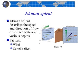
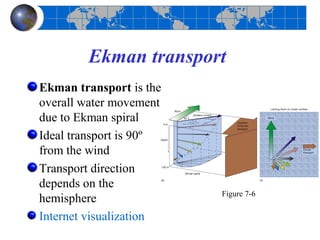
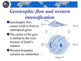
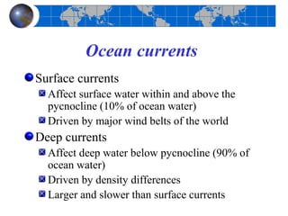
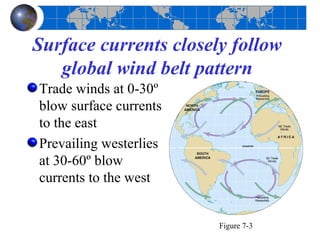
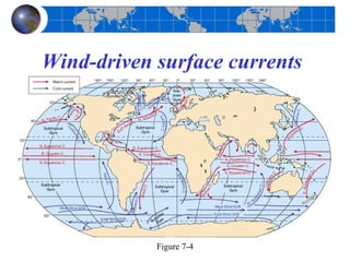
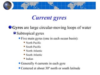
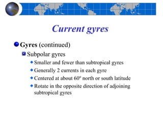
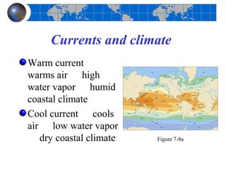
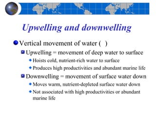
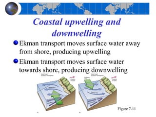
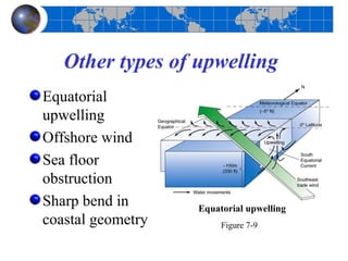
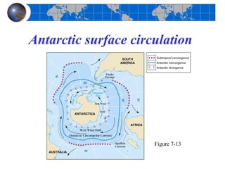
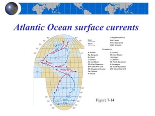
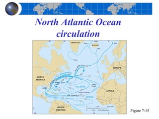
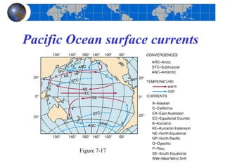
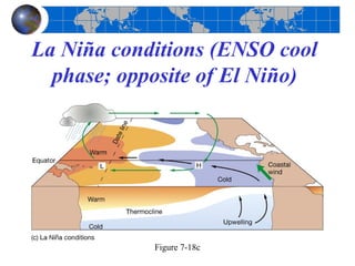
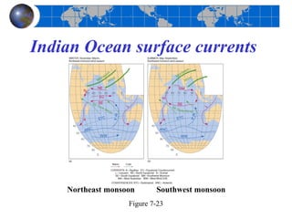
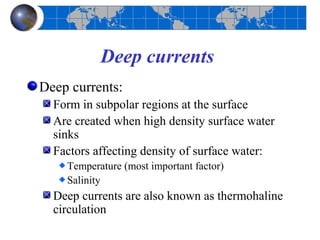
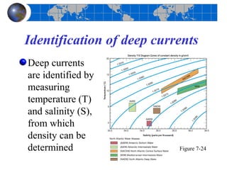
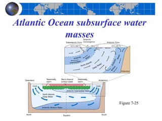
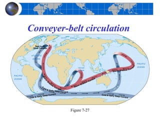
Chapter 7
 Ocean Circulation

Essentials of Oceanography
         7th Edition
Ocean currents
Surface currents
  Affect surface water within and above the
  pycnocline (10% of ocean water)
  Driven by major wind belts of the world
Deep currents
  Affect deep water below pycnocline (90% of
  ocean water)
  Driven by density differences
  Larger and slower than surface currents
Measuring surface currents
Direct methods
  Float meters
     Intentional
     Inadvertent
  Propeller meters
Indirect methods
  Pressure gradients
  Satellites
  Doppler flow meters   Figure 7B
Surface currents closely follow
   global wind belt pattern
Trade winds at 0-30º
blow surface currents
to the east
Prevailing westerlies
at 30-60º blow
currents to the west


                        Figure 7-3
Wind-driven surface currents


            Figure 7-4
Current gyres
Gyres are large circular-moving loops of water
  Subtropical gyres
     Five main gyres (one in each ocean basin):
       North  Pacific
       South Pacific
       North Atlantic
       South Atlantic
       Indian

     Generally 4 currents in each gyre
     Centered at about 30º north or south latitude
Current gyres
Gyres (continued)
  Subpolar gyres
    Smaller and fewer than subtropical gyres
    Generally 2 currents in each gyre
    Centered at about 60º north or south latitude
    Rotate in the opposite direction of adjoining
    subtropical gyres
Ekman spiral
Ekman spiral
describes the speed
and direction of flow
of surface waters at
various depths
Factors:
  Wind
                           Figure 7-6
  Coriolis effect
Ekman transport
Ekman transport is the
overall water movement
due to Ekman spiral
Ideal transport is 90º
from the wind
Transport direction
depends on the
                         Figure 7-6
hemisphere
Internet visualization
Geostrophic flow and western
       intensification
Geostrophic flow
causes a hill to form in
subtropical gyres
The center of the gyre
is shifted to the west
because of Earth’s
rotation
Western boundary
currents are intensified
                           Figure 7-7
Western intensification of
     subtropical gyres
The western boundary currents of all
subtropical gyres are:
  Fast
  Narrow
  Deep
Western boundary currents are also warm
Eastern boundary currents of subtropical
gyres have opposite characteristics
Currents and climate
Warm current
warms air high
water vapor humid
coastal climate
Cool current cools
air low water vapor
   dry coastal climate   Figure 7-8a
Upwelling and downwelling
Vertical movement of water ( )
  Upwelling = movement of deep water to surface
    Hoists cold, nutrient-rich water to surface
    Produces high productivities and abundant marine life
  Downwelling = movement of surface water down
    Moves warm, nutrient-depleted surface water down
    Not associated with high productivities or abundant
    marine life
Coastal upwelling and
        downwelling
Ekman transport moves surface water away
from shore, producing upwelling
Ekman transport moves surface water
towards shore, producing downwelling


                                Figure 7-11
Other types of upwelling
Equatorial
upwelling
Offshore wind
Sea floor
obstruction
Sharp bend in      Equatorial upwelling
coastal geometry        Figure 7-9
Antarctic surface circulation


                      Figure 7-13
Atlantic Ocean surface currents


                    Figure 7-14
North Atlantic Ocean
     circulation


                       Figure 7-15
The Gulf Stream and sea
   surface temperatures
The Gulf Stream is
a warm, western
intensified current
Meanders as it
moves into the
North Atlantic
Creates warm and
cold core rings
                      Figure 7-16
Pacific Ocean surface currents


         Figure 7-17
El Niño-Southern Oscillation
          (ENSO)
El Niño = warm surface current in
equatorial eastern Pacific that occurs
periodically around Christmastime
Southern Oscillation = change in
atmospheric pressure over Pacific Ocean
accompanying El Niño
ENSO describes a combined oceanic-
atmospheric disturbance
Normal conditions in the Pacific
           Ocean


             Figure 7-18a
El Niño conditions (ENSO
      warm phase)


         Figure 7-18b
La Niña conditions (ENSO cool
  phase; opposite of El Niño)


            Figure 7-18c
The 1997-98 El Niño
Sea surface
temperature anomaly
map shows warming
during severe 1997-98
El Niño
Internet site for El Ni
ño visualizations
Current state of the tropical Pacific
                                   Figure 7-19a
El Niño recurrence interval
Typical recurrence interval for El Niños =
2-12 years
Pacific has alternated between El Niño and
La Niña events since 1950


                                        Figure 7-20
Effects of severe El Niños


          Figure 7-21
Indian Ocean surface currents


    Northeast monsoon      Southwest monsoon
                   Figure 7-23
Deep currents
Deep currents:
  Form in subpolar regions at the surface
  Are created when high density surface water
  sinks
  Factors affecting density of surface water:
    Temperature (most important factor)
    Salinity
  Deep currents are also known as thermohaline
  circulation
Deep ocean characteristics
Conditions of the deep ocean:
  Cold
  Still
  Dark
  Essentially no productivity
  Sparse life
  Extremely high pressure
Identification of deep currents
Deep currents
are identified by
measuring
temperature (T)
and salinity (S),
from which
density can be
determined                 Figure 7-24
Atlantic Ocean subsurface water
            masses


                        Figure 7-25
Conveyer-belt circulation


          Figure 7-27
End of Chapter 7


Essentials of Oceanography
         7th Edition

Chapter 7 Ocean Circulation

  • 1.
    Chapter 7 OceanCirculation Essentials of Oceanography 7th Edition
  • 2.
    Ocean currents Surface currents Affect surface water within and above the pycnocline (10% of ocean water) Driven by major wind belts of the world Deep currents Affect deep water below pycnocline (90% of ocean water) Driven by density differences Larger and slower than surface currents
  • 3.
    Measuring surface currents Directmethods Float meters Intentional Inadvertent Propeller meters Indirect methods Pressure gradients Satellites Doppler flow meters Figure 7B
  • 4.
    Surface currents closelyfollow global wind belt pattern Trade winds at 0-30º blow surface currents to the east Prevailing westerlies at 30-60º blow currents to the west Figure 7-3
  • 5.
  • 6.
    Current gyres Gyres arelarge circular-moving loops of water Subtropical gyres Five main gyres (one in each ocean basin):  North Pacific  South Pacific  North Atlantic  South Atlantic  Indian Generally 4 currents in each gyre Centered at about 30º north or south latitude
  • 7.
    Current gyres Gyres (continued) Subpolar gyres Smaller and fewer than subtropical gyres Generally 2 currents in each gyre Centered at about 60º north or south latitude Rotate in the opposite direction of adjoining subtropical gyres
  • 8.
    Ekman spiral Ekman spiral describesthe speed and direction of flow of surface waters at various depths Factors: Wind Figure 7-6 Coriolis effect
  • 9.
    Ekman transport Ekman transportis the overall water movement due to Ekman spiral Ideal transport is 90º from the wind Transport direction depends on the Figure 7-6 hemisphere Internet visualization
  • 10.
    Geostrophic flow andwestern intensification Geostrophic flow causes a hill to form in subtropical gyres The center of the gyre is shifted to the west because of Earth’s rotation Western boundary currents are intensified Figure 7-7
  • 11.
    Western intensification of subtropical gyres The western boundary currents of all subtropical gyres are: Fast Narrow Deep Western boundary currents are also warm Eastern boundary currents of subtropical gyres have opposite characteristics
  • 12.
    Currents and climate Warmcurrent warms air high water vapor humid coastal climate Cool current cools air low water vapor dry coastal climate Figure 7-8a
  • 13.
    Upwelling and downwelling Verticalmovement of water ( ) Upwelling = movement of deep water to surface Hoists cold, nutrient-rich water to surface Produces high productivities and abundant marine life Downwelling = movement of surface water down Moves warm, nutrient-depleted surface water down Not associated with high productivities or abundant marine life
  • 14.
    Coastal upwelling and downwelling Ekman transport moves surface water away from shore, producing upwelling Ekman transport moves surface water towards shore, producing downwelling Figure 7-11
  • 15.
    Other types ofupwelling Equatorial upwelling Offshore wind Sea floor obstruction Sharp bend in Equatorial upwelling coastal geometry Figure 7-9
  • 16.
  • 17.
    Atlantic Ocean surfacecurrents Figure 7-14
  • 18.
    North Atlantic Ocean circulation Figure 7-15
  • 19.
    The Gulf Streamand sea surface temperatures The Gulf Stream is a warm, western intensified current Meanders as it moves into the North Atlantic Creates warm and cold core rings Figure 7-16
  • 20.
    Pacific Ocean surfacecurrents Figure 7-17
  • 21.
    El Niño-Southern Oscillation (ENSO) El Niño = warm surface current in equatorial eastern Pacific that occurs periodically around Christmastime Southern Oscillation = change in atmospheric pressure over Pacific Ocean accompanying El Niño ENSO describes a combined oceanic- atmospheric disturbance
  • 22.
    Normal conditions inthe Pacific Ocean Figure 7-18a
  • 23.
    El Niño conditions(ENSO warm phase) Figure 7-18b
  • 24.
    La Niña conditions(ENSO cool phase; opposite of El Niño) Figure 7-18c
  • 25.
    The 1997-98 ElNiño Sea surface temperature anomaly map shows warming during severe 1997-98 El Niño Internet site for El Ni ño visualizations Current state of the tropical Pacific Figure 7-19a
  • 26.
    El Niño recurrenceinterval Typical recurrence interval for El Niños = 2-12 years Pacific has alternated between El Niño and La Niña events since 1950 Figure 7-20
  • 27.
    Effects of severeEl Niños Figure 7-21
  • 28.
    Indian Ocean surfacecurrents Northeast monsoon Southwest monsoon Figure 7-23
  • 29.
    Deep currents Deep currents: Form in subpolar regions at the surface Are created when high density surface water sinks Factors affecting density of surface water: Temperature (most important factor) Salinity Deep currents are also known as thermohaline circulation
  • 30.
    Deep ocean characteristics Conditionsof the deep ocean: Cold Still Dark Essentially no productivity Sparse life Extremely high pressure
  • 31.
    Identification of deepcurrents Deep currents are identified by measuring temperature (T) and salinity (S), from which density can be determined Figure 7-24
  • 32.
    Atlantic Ocean subsurfacewater masses Figure 7-25
  • 33.
  • 34.
    End of Chapter7 Essentials of Oceanography 7th Edition