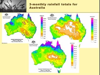
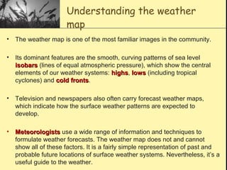
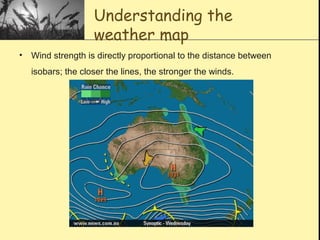
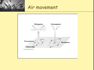
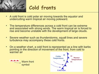
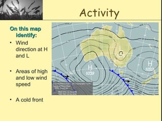
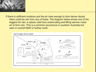
2. Why is the weather
important?
• Impacts on the timing of operations such
as crop spraying or hay cutting
• Can determine seasonal decisions like
sowing or lambing
• Climate can also have a long term impact
on vegetation and soil resources, which
affect farmers financially
6. Understanding the weather
map
• The weather map is one of the most familiar images in the community.
• Its dominant features are the smooth, curving patterns of sea level
isobarsisobars (lines of equal atmospheric pressure), which show the central
elements of our weather systems: highshighs, lowslows (including tropical
cyclones) and cold frontscold fronts.
• Television and newspapers also often carry forecast weather maps,
which indicate how the surface weather patterns are expected to
develop.
• MeteorologistsMeteorologists use a wide range of information and techniques to
formulate weather forecasts. The weather map does not and cannot
show all of these factors. It is a fairly simple representation of past and
probable future locations of surface weather systems. Nevertheless, it’s a
useful guide to the weather.
7. Understanding the
weather map
• Wind strength is directly proportional to the distance between
isobars; the closer the lines, the stronger the winds.
8. High Pressure Systems
• The air spirals anti-clockwise in a high pressure
system.
• The air associated with a high pressure system
sinks down from above and warms as it does so
and is very stable.
• A high pressure system (anticyclone), is a system
of closed isobars surrounding a region of relatively
high pressure. When compared with low pressure
systems, highs tend to cover a greater area, move
more slowly and have a longer life.
• When the high pressure system is located over land
the weather will be typically dry and free of cloud.
9. Low pressure systems
• The air spirals clockwise in a low pressure system.
• A low pressure system (cyclone) develops where
relatively warm air ascends from the Earth's surface.
• These are systems of closed isobars surrounding a
region of relatively low pressure. As the rising air cools,
clouds will begin to form. The instability of the air will
produce clouds with associated rain showers.
• An elongated extension of isobars away from a low
pressure centre is known as a trough of low pressure.
This trough usually contains one or more cold fronts.
11. Cold fronts
• A cold front is cold polar air moving towards the equator and
undercutting warm tropical air moving poleward.
• The temperature differences across a cold front can be extreme
and associated with strong winds. The warm tropical air is forced to
rise and become unstable with the development of large clouds.
• Severe weather such as thunderstorms, squall lines and severe
turbulence may accompany these cold fronts.
• On a weather chart, a cold front is represented as a line with barbs
pointing in the direction of movement of the front, from cold to
warmer air
Warm front
symbol
12. Activity
On this mapOn this map
identify:identify:
• Wind
direction at H
and L
• Areas of high
and low wind
speed
• A cold front
13. What makes it rain?
• To create rain you need MoistureMoisture and a
TriggerTrigger
i.e. Moisture x Trigger = raini.e. Moisture x Trigger = rain
(these are independent of each other)(these are independent of each other)
• Evaporation from warmer ocean waters
provides the main source of moisture. Cooler air
originating from the Southern Ocean will have
less moisture available for precipitation,
although good falls will still occur in these
systems from time to time.
15. What are the mechanisms
to trigger rainfall?
For rain to fall, moist air needs to cool, resulting in
condensation of vapour. This is commonly achieved by
something which forces the air to rise.
Air rises because of:
• hills and mountains (orographic lift)
• irregularities on the earth surface, causing mechanical or
frictional turbulence
• air pressure systems colliding, such as cold fronts
undercutting warmer air
• low pressure systems, in which there is a general area of
upward movement
• Sunset – the heating is removed allowing the air to cool
• A trough of low pressure where the air expands,
spreading the heat and cooling slightly.
16. If there is sufficient moisture and the air rises enough to form dense clouds
there could be rain from any of these. The diagram below shows one of the
triggers for rain, a classic cold front undercutting and lifting warmer moist
air to form rain. This is a common occurrence in southern Australia but
rarer in central NSW or further north.
17. Do clouds mean rain?
• The clouds from which rain fall are just
the visible sign of condensation activity.
• All the water in a cloud 1km high would
only be 1mm deep on the ground.
• To get rainfall in amounts useful to
agriculture require inflow of moist air fro
some time and for the conditions inducing
condensation to remain in force.