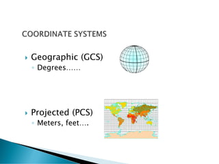
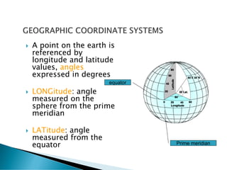
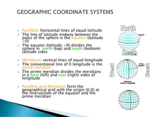
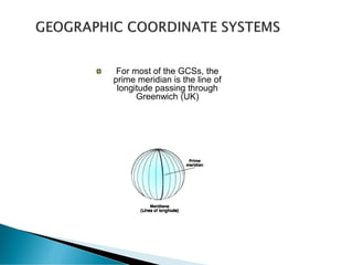
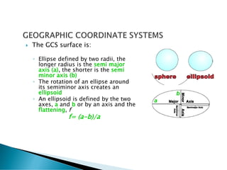
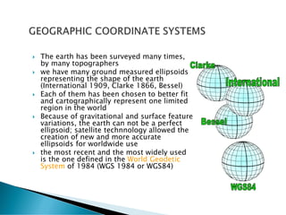
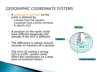
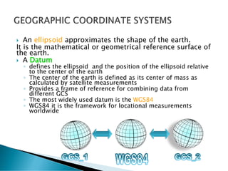
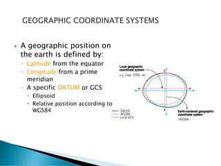
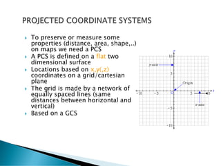
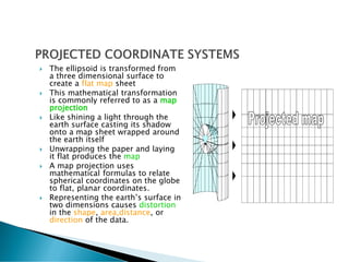
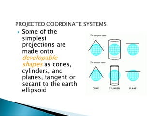
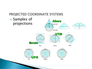
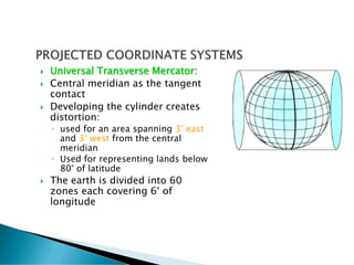
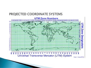
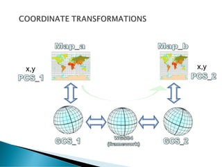
Coordinate System
&
Geo-Referencing
 Geographic (GCS)
◦ Degrees……
 Projected (PCS)
◦ Meters, feet….
 A GCS is a three dimensional
“spherical” surface used to
define a location on the
earth by:
◦ Equator
◦ Prime meridian
 A point on the earth is
referenced by
longitude and latitude
values, angles
expressed in degrees
 LONGitude: angle
measured on the
sphere from the prime
meridian
 LATitude: angle
measured from the
equator
equator
Prime meridian
 Parallels: horizontal lines of equal latitude
 The line of latitude midway between the
poles of the sphere is the equator (latitude
=0)
 The equator (latitude =0) divides the
sphere in north (top) and south (bottom)
latitude sides
 Meridians: vertical lines of equal longitude
 The conventional line of 0 longitude is the
prime meridian
 The prime meridian divides the meridians
in a west (left) and east (right) sides of
longitude
 Parallels and Meridians form the
geographical grid with the origin (0,0) at
the intersection of the equator and the
prime meridian
For most of the GCSs, the
prime meridian is the line of
longitude passing through
Greenwich (UK)
 Latitude and longitude are
measured in degrees, minutes
and seconds (DMS) or decimal
degrees (DD)
 Longitude ranges between -180°
(or 180 west) and +180° (or 180
east)
 Latitude ranges between -90° (or
90° south) and +90° (or 90°
north)
 Above and below the equator the
latitude lines (circles) gradually
become smaller
 Only along the equator one
degree of latitude represents the
111.12 Kilometers)
 The GCS surface is:
◦ Ellipse defined by two radii, the
longer radius is the semi major
axis (a), the shorter is the semi
minor axis (b)
◦ The rotation of an ellipse around
its semiminor axis creates an
ellipsoid
◦ An ellipsoid is defined by the two
axes, a and b or by an axis and the
flattening, f
f= (a-b)/a
a
b
 The earth has been surveyed many times,
by many topographers
 we have many ground measured ellipsoids
representing the shape of the earth
(International 1909, Clarke 1866, Bessel)
 Each of them has been chosen to better fit
and cartographically represent one limited
region in the world
 Because of gravitational and surface feature
variations, the earth can not be a perfect
ellipsoid; satellite technnology allowed the
creation of new and more accurate
ellipsoids for worldwide use
 the most recent and the most widely used
is the one defined in the World Geodetic
System of 1984 (WGS 1984 or WGS84)
 A geographic position on the
earth is defined by:
◦ Latitude from the equator
◦ Longitude from a prime meridian
◦ A specific GCS
 A position on the earth could
have different longitude and
latitude if the GCS is different
 The difference is always around
seconds or fractions of a second
 The error of setting a wrong
GCS in a GPS system could
affect the coordinates on a map
even of hundred meters
equator
Prime meridian
 An ellipsoid approximates the shape of the earth.
It is the mathematical or geometrical reference surface of
the earth.
 A Datum
◦ defines the ellipsoid and the position of the ellipsoid relative
to the center of the earth
◦ The center of the earth is defined as its center of mass as
calculated by satellite measurements
◦ Provides a frame of reference for combining data from
different GCS
◦ The most widely used datum is the WGS84
◦ WGS84 it is the framework for locational measurements
worldwide
 A geographic position on
the earth is defined by:
◦ Latitude from the equator
◦ Longitude from a prime
meridian
◦ A specific DATUM or GCS
 Ellipsoid
 Relative position according to
WGS84
 To preserve or measure some
properties (distance, area, shape,..)
on maps we need a PCS
 A PCS is defined on a flat two
dimensional surface
 Locations based on x,y(,z)
coordinates on a grid/cartesian
plane
 The grid is made by a network of
equally spaced lines (same
distances between horizontal and
vertical)
 Based on a GCS
 The ellipsoid is transformed from
a three dimensional surface to
create a flat map sheet
 This mathematical transformation
is commonly referred to as a map
projection
 Like shining a light through the
earth surface casting its shadow
onto a map sheet wrapped around
the earth itself
 Unwrapping the paper and laying
it flat produces the map
 A map projection uses
mathematical formulas to relate
spherical coordinates on the globe
to flat, planar coordinates.
 Representing the earth’s surface in
two dimensions causes distortion
in the shape, area,distance, or
direction of the data.
 Different projections cause different
distortions
 Projections could be:
◦ Conformal
 Preserve local shapes, mantaining angles
 Meridians and parallels intersect at 90° angles
◦ Equal area
 Preserve the area
 Meridians and parallels may not intersect at right angles
◦ Equidistant
 Preserve distances betweeen certain points
 No projection is equidistant for all points in the map
 Some of the
simplest
projections are
made onto
developable
shapes as cones,
cylinders, and
planes, tangent or
secant to the earth
ellipsoid
 Samples of
projections
 Universal Transverse Mercator:
 Central meridian as the tangent
contact
 Developing the cylinder creates
distortion:
◦ used for an area spanning 3° east
and 3° west from the central
meridian
◦ Used for representing lands below
80° of latitude
 The earth is divided into 60
zones each covering 6° of
longitude
 a
x,y x,y
 Why considering coordinate systems, projections
and transformations?
◦ Locating correctly a GPS point onto a map
◦ Overlaying different map data sources (a vegetation map, a
soil map, etc. )
◦ Performing spatial analysis
◦ Deriving coordinates using a topographic map in the field
◦ Specifying coordinates without errors
 equipotential surface of the Earth
gravitational field that most closely
approximates the mean sea surface
 The geoid surface is described by geoid
heights that refer to a suitable Earth
reference ellipsoid
 Geoid heights are relative small, the
minimum of some -106 meters is located at
the Indian Ocean, the maximum geoid
height is about 85 meters.
 Elevation/altitude is measured above mean
sea level (AMSL)
global map with geoid heights of the EGM96 gravity field model,
computed relative to the GRS80 ellipsoid

Coordinate System.pdf

  • 1.
  • 2.
     Geographic (GCS) ◦Degrees……  Projected (PCS) ◦ Meters, feet….
  • 3.
     A GCSis a three dimensional “spherical” surface used to define a location on the earth by: ◦ Equator ◦ Prime meridian
  • 4.
     A pointon the earth is referenced by longitude and latitude values, angles expressed in degrees  LONGitude: angle measured on the sphere from the prime meridian  LATitude: angle measured from the equator equator Prime meridian
  • 5.
     Parallels: horizontallines of equal latitude  The line of latitude midway between the poles of the sphere is the equator (latitude =0)  The equator (latitude =0) divides the sphere in north (top) and south (bottom) latitude sides  Meridians: vertical lines of equal longitude  The conventional line of 0 longitude is the prime meridian  The prime meridian divides the meridians in a west (left) and east (right) sides of longitude  Parallels and Meridians form the geographical grid with the origin (0,0) at the intersection of the equator and the prime meridian
  • 6.
    For most ofthe GCSs, the prime meridian is the line of longitude passing through Greenwich (UK)
  • 7.
     Latitude andlongitude are measured in degrees, minutes and seconds (DMS) or decimal degrees (DD)  Longitude ranges between -180° (or 180 west) and +180° (or 180 east)  Latitude ranges between -90° (or 90° south) and +90° (or 90° north)  Above and below the equator the latitude lines (circles) gradually become smaller  Only along the equator one degree of latitude represents the 111.12 Kilometers)
  • 8.
     The GCSsurface is: ◦ Ellipse defined by two radii, the longer radius is the semi major axis (a), the shorter is the semi minor axis (b) ◦ The rotation of an ellipse around its semiminor axis creates an ellipsoid ◦ An ellipsoid is defined by the two axes, a and b or by an axis and the flattening, f f= (a-b)/a a b
  • 9.
     The earthhas been surveyed many times, by many topographers  we have many ground measured ellipsoids representing the shape of the earth (International 1909, Clarke 1866, Bessel)  Each of them has been chosen to better fit and cartographically represent one limited region in the world  Because of gravitational and surface feature variations, the earth can not be a perfect ellipsoid; satellite technnology allowed the creation of new and more accurate ellipsoids for worldwide use  the most recent and the most widely used is the one defined in the World Geodetic System of 1984 (WGS 1984 or WGS84)
  • 10.
     A geographicposition on the earth is defined by: ◦ Latitude from the equator ◦ Longitude from a prime meridian ◦ A specific GCS  A position on the earth could have different longitude and latitude if the GCS is different  The difference is always around seconds or fractions of a second  The error of setting a wrong GCS in a GPS system could affect the coordinates on a map even of hundred meters equator Prime meridian
  • 11.
     An ellipsoidapproximates the shape of the earth. It is the mathematical or geometrical reference surface of the earth.  A Datum ◦ defines the ellipsoid and the position of the ellipsoid relative to the center of the earth ◦ The center of the earth is defined as its center of mass as calculated by satellite measurements ◦ Provides a frame of reference for combining data from different GCS ◦ The most widely used datum is the WGS84 ◦ WGS84 it is the framework for locational measurements worldwide
  • 12.
     A geographicposition on the earth is defined by: ◦ Latitude from the equator ◦ Longitude from a prime meridian ◦ A specific DATUM or GCS  Ellipsoid  Relative position according to WGS84
  • 13.
     To preserveor measure some properties (distance, area, shape,..) on maps we need a PCS  A PCS is defined on a flat two dimensional surface  Locations based on x,y(,z) coordinates on a grid/cartesian plane  The grid is made by a network of equally spaced lines (same distances between horizontal and vertical)  Based on a GCS
  • 14.
     The ellipsoidis transformed from a three dimensional surface to create a flat map sheet  This mathematical transformation is commonly referred to as a map projection  Like shining a light through the earth surface casting its shadow onto a map sheet wrapped around the earth itself  Unwrapping the paper and laying it flat produces the map  A map projection uses mathematical formulas to relate spherical coordinates on the globe to flat, planar coordinates.  Representing the earth’s surface in two dimensions causes distortion in the shape, area,distance, or direction of the data.
  • 15.
     Different projectionscause different distortions  Projections could be: ◦ Conformal  Preserve local shapes, mantaining angles  Meridians and parallels intersect at 90° angles ◦ Equal area  Preserve the area  Meridians and parallels may not intersect at right angles ◦ Equidistant  Preserve distances betweeen certain points  No projection is equidistant for all points in the map
  • 16.
     Some ofthe simplest projections are made onto developable shapes as cones, cylinders, and planes, tangent or secant to the earth ellipsoid
  • 17.
  • 18.
     Universal TransverseMercator:  Central meridian as the tangent contact  Developing the cylinder creates distortion: ◦ used for an area spanning 3° east and 3° west from the central meridian ◦ Used for representing lands below 80° of latitude  The earth is divided into 60 zones each covering 6° of longitude
  • 19.
  • 20.
  • 21.
     Why consideringcoordinate systems, projections and transformations? ◦ Locating correctly a GPS point onto a map ◦ Overlaying different map data sources (a vegetation map, a soil map, etc. ) ◦ Performing spatial analysis ◦ Deriving coordinates using a topographic map in the field ◦ Specifying coordinates without errors
  • 22.
     equipotential surfaceof the Earth gravitational field that most closely approximates the mean sea surface  The geoid surface is described by geoid heights that refer to a suitable Earth reference ellipsoid  Geoid heights are relative small, the minimum of some -106 meters is located at the Indian Ocean, the maximum geoid height is about 85 meters.  Elevation/altitude is measured above mean sea level (AMSL)
  • 25.
    global map withgeoid heights of the EGM96 gravity field model, computed relative to the GRS80 ellipsoid