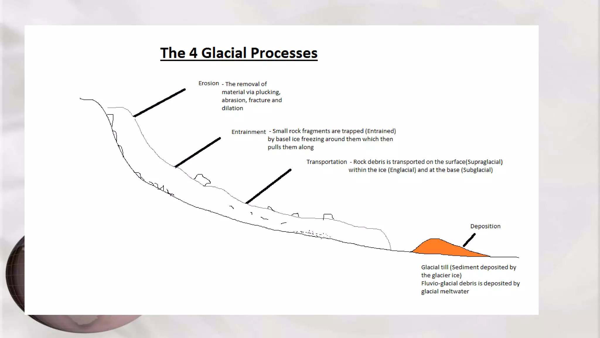
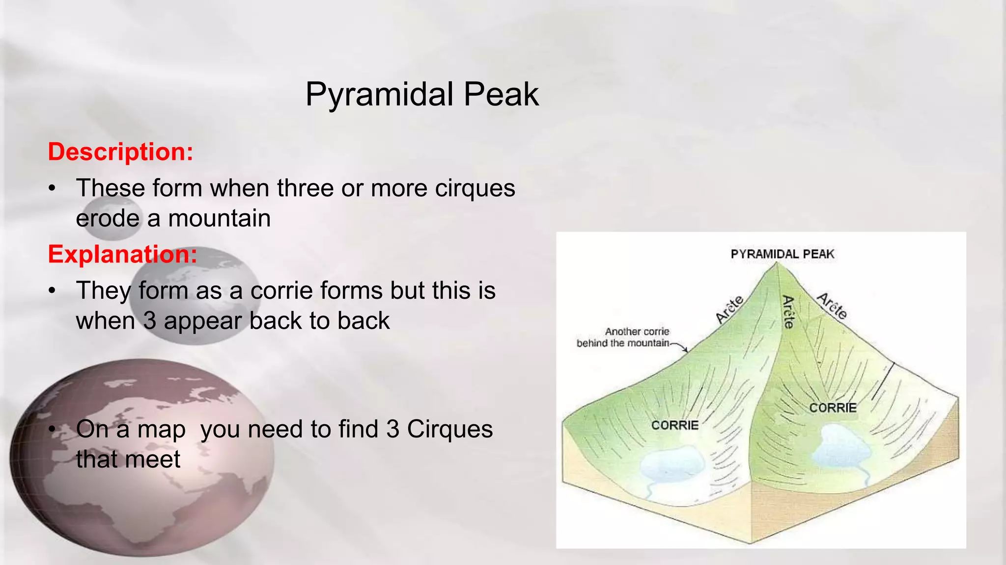
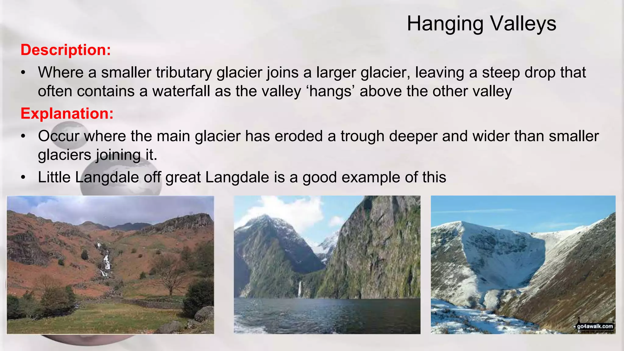
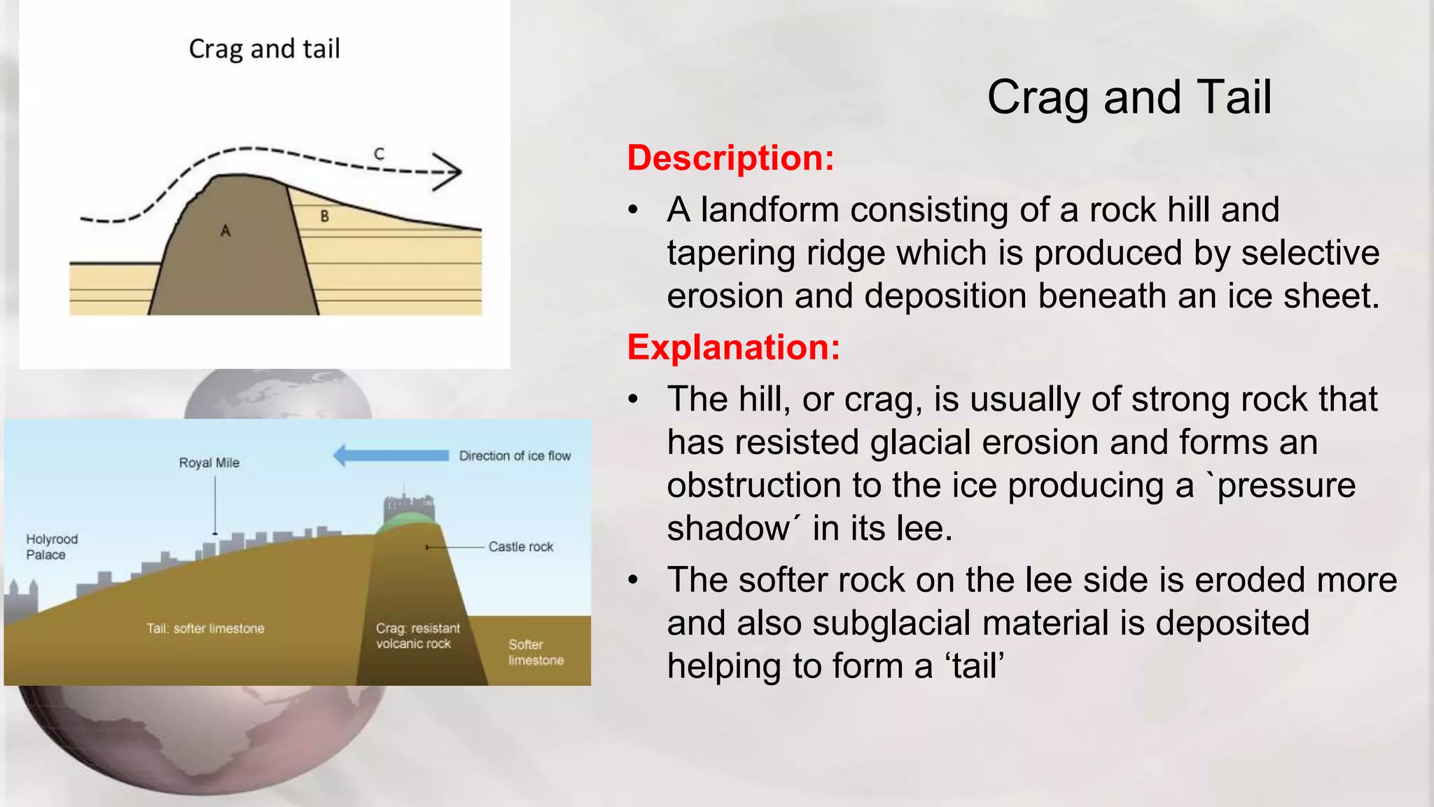
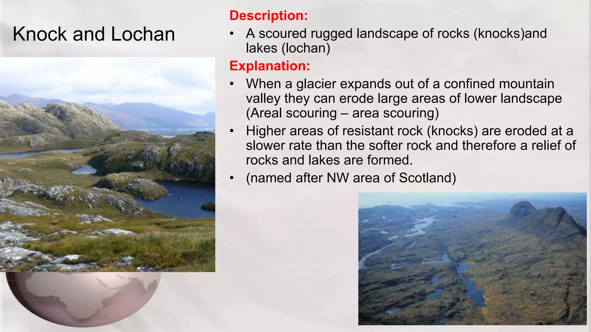
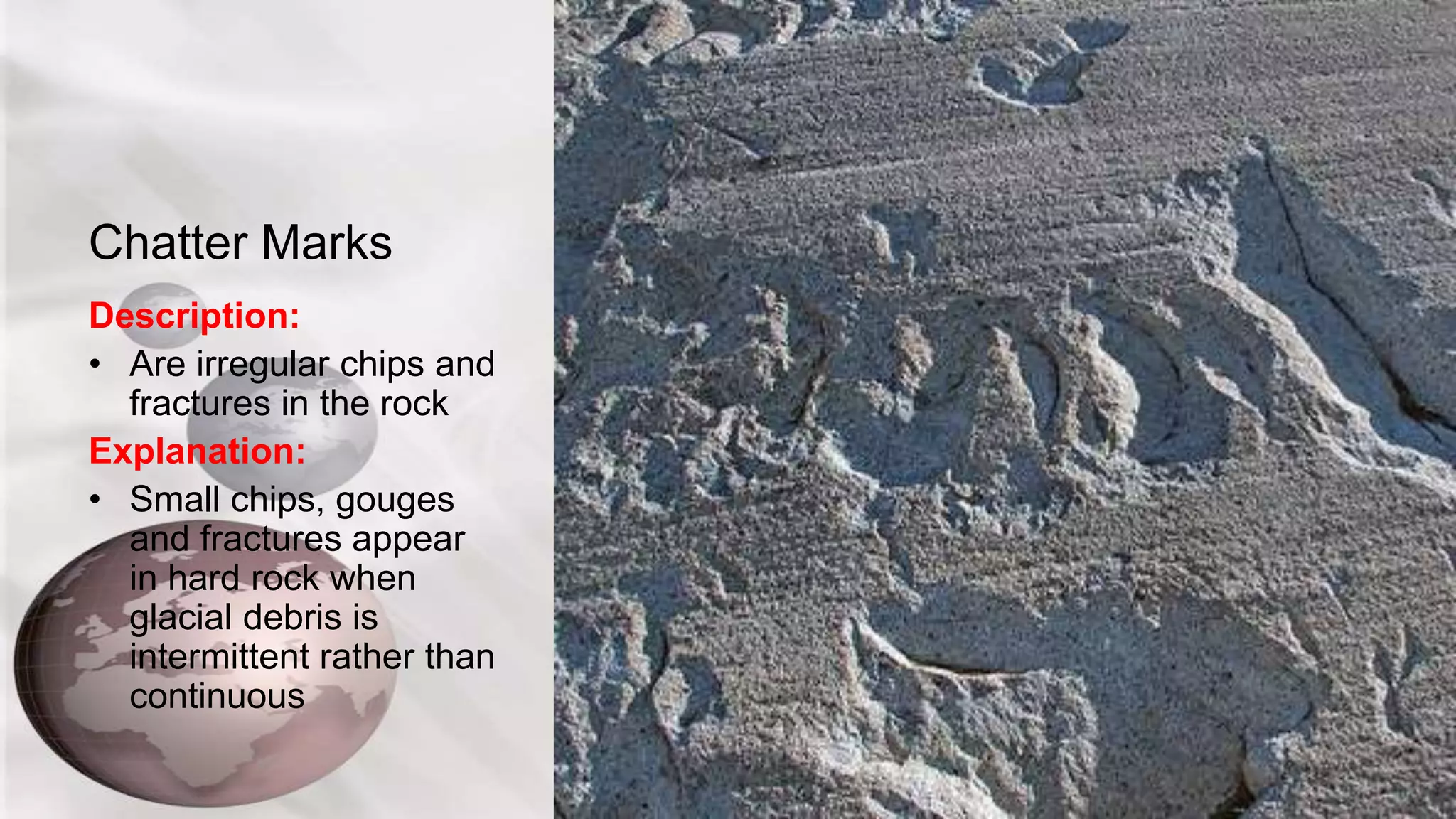
Glacial Processes and Landforms
Lower Sixth
In this lecture
• We will investigate the factors that impact upon glacial
erosion rates
• Appreciate the size and scale and variety of different
landforms in highland glaciation
• Examine the landscapes formed by glacial scouring
• Begin to investigate the landforms and landscapes of
glacial deposition
The factors affecting the rates of Glacial
Erosion
Consider these and in pairs try to think why these might affect the
rates of glacial erosion
Factors
controlling the
rate of glacier
movement
ICE THICKNESS
PRECIPITATION
LEVELS
RATES OF
ABLATION
BEDROCK
PERMEABILITY
ICE AND SLOPE
GRADIENT
ICE TEMPERATURE
ICE THICKNESS
• When 50m
thick plastic
flow begins
• Greater
Thickness
greater
pressure
causing
increased
movement
PRECIPITATION
LEVELS
• Higher
snowfall =
greater
accumulation
and more
weight so
increase rate
of movement
RATES OF
ABALATION
• The more
meltwater =
increase in
basal sliding
therefore
increase in
movement
BEDROCK
PERMEABILITY
• If bedrock is
permeable then
then meltwater
can percolate
away which can
slow the
movement of
the glacier
• Movement over
a softer rock
can increase
movement
ICE AND SLOPE
GRADIENT
• The steeper
the angle of
slope the
faster the
movement
ICE
TEMPERATURE
• Colder ice
moves slower
than warmer ice
as it does not
deform as easily
and sticks to the
bedrock
From these factors we can make several
assumptions
• Explain why erosion rates tend to be higher in warm based glaciers because (4)
• Explain why slope gradient and angle can have a large influence on erosion (4)
• Explain why Alpine glaciers tend to move faster due to rates of ablation (4)
• Remember:
• All of the 6 factors can play a role and they work at different rates on different
glaciers
Can you rank the 6 factors as to which is the most important and be ready to explain
why
• Explain the conditions needed for high rates of glacial erosion (6)
Glacier landforms and landscapes
• Glaciers we know alter landscapes
• The landforms they create vary in scale
The 4 glacial processes
GLACIALPROCESSES
EROSION
The removal of material via plucking, abrasion, fracture and dilation
ENTRAINMENT
Small rock fragments are trapped (Entrained) by basel ice freezing
around them which then pulls them along
TRANSPORT
Rock debris is transported on the surface(Supraglacial) within the ice
(Englacial) and at the base (Subglacial)
DEPOSITION
Glacial till (Sediment deposited by the glacier ice)
Fluvio-glacial debris is deposited by glacial meltwater
Complexity
• Present day landforms can exist from
several glacial periods and not just the last
one
• They are the product of many successive
advances during ice-house conditions and
retreats during green-house conditions
• These are known as polycyclic or
polygenetic
The glacial features! – Macro-scale
• All the macro features listed here need to be known,
explained and identified by picture or map.
MACRO FEATURES – All above 1km or greater in size
Cirque/ Corrie/ cwn Truncated Spur
Arête Hanging Valley
Pyramidal Peak Trough (U-shaped Valley)
Cirque/ Corrie/ cwn
• These words refer to the same thing
• There are three stages to their creation
Description:
• Is an amphitheatre-like valley formed by glacial erosion
Explanation:
1. The process of nivation creates and enlarges a hollow (This is a positive
feedback)
2. The headwall is steepened by freeze-thaw and plucking
3. The hollow is deepened by glacial abrasion
Using the maps provided
Arête
Description:
Is a sharp knife like ridge that separates two cirques on a mountain.
Explanation:
• They are formed when two corries are created back to back
Pyramidal Peak
Description:
• These form when three or more cirques
erode a mountain
Explanation:
• They form as a corrie forms but this is
when 3 appear back to back
• On a map you need to find 3 Cirques
that meet
In Welsh a Cirque is called a ‘cwm’
Truncated Spur
Description:
• These were spurs from the pre-glacial meandering of a river.
Explanation:
The spurs have been gradually cut away (‘truncated’) by the glacier as it moves down
the valley because glaciers can not easily move around obstacles like a river and so cut
through.
Locating on a map
• First you’ll need to identify a U shaped valley and then
‘scree’ like black markings parallel to the sides of the
valley should help indicate truncated spurs
U Shaped Valley
Description:
• Deep sided steep valleys that
are generally U shaped with a
misfit stream found at the bottom
Explanation:
These occur where the glacier has
carved through a mountain valley,
straightening, widening and
deepening it as it goes
Glacial troughs often have ribbon
lakes within them such as
Windermere in the Lake District
Hanging Valleys
Description:
• Where a smaller tributary glacier joins a larger glacier, leaving a steep drop that
often contains a waterfall as the valley ‘hangs’ above the other valley
Explanation:
• Occur where the main glacier has eroded a trough deeper and wider than smaller
glaciers joining it.
• Little Langdale off great Langdale is a good example of this
Ribbon Lakes
Description:
• Long narrow which can form along the base of glacial troughs
Explanation:
• Glacier erodes softer rock at the bottom of the glacial trough and can be dammed by
moraine material at one end then as ice melts it creates a lake that dependant on
geology will remain or disappear over time
Meso-scale Features
• Meso features are mainly found within a macro feature
good examples of these are found in Yosemite National
Park and include
• Whalebacks
• Roches Moutonnées
• Crag and Tail
• Meso features are between 10m and 1km in length
Whalebacks
Description:
• These are streamlined bedrock feature.
Explanation:
• where a glacier moves over resistant bedrock
(rocky knoll) and abrading it on all sides
causing it to be smoothed and rounded on all
sides
• The shape becomes blunted at the up glacier
side and tapers on the down glacier side
• Whalebacks do not have a steep ‘plucked’
side
• OFTEN REFERRED TO A STREAMLINED
HILLS
Roches Moutonnées
Description:
• Smooth shaped rocky knoll with one steeped side which is rough and plucked.
Explanation:
• Formed by plucking and abrasion. The abrasion smooths the up glacier side
called the ‘STOSS’ side whilst plucking and freeze thaw has made the ‘LEE’ side
more jagged and craggy.
• They can often form in groups
Crag and Tail
Description:
• A landform consisting of a rock hill and
tapering ridge which is produced by selective
erosion and deposition beneath an ice sheet.
Explanation:
• The hill, or crag, is usually of strong rock that
has resisted glacial erosion and forms an
obstruction to the ice producing a `pressure
shadow´ in its lee.
• The softer rock on the lee side is eroded more
and also subglacial material is deposited
helping to form a ‘tail’
Knock and Lochan
Description:
• A scoured rugged landscape of rocks (knocks)and
lakes (lochan)
Explanation:
• When a glacier expands out of a confined mountain
valley they can erode large areas of lower landscape
(Areal scouring – area scouring)
• Higher areas of resistant rock (knocks) are eroded at a
slower rate than the softer rock and therefore a relief of
rocks and lakes are formed.
• (named after NW area of Scotland)
Micro-Scale Features
• These are a few metres or less in size
• Striations
• Chatter marks
• Crescentic Gouges
• Striations are scratches in the bedrock caused by the
ice dragging debris across the surface
Striations
Description:
• Long thin scratches on the visible rock
Explanation:
• Formed as glacial debris is dragged along the
surface by the ice (abrasion). They therefore
orientate parallel to the direction of ice flow, usually
only a few mm deep but can vary in length
Chatter Marks
Description:
• Are irregular chips and
fractures in the rock
Explanation:
• Small chips, gouges
and fractures appear
in hard rock when
glacial debris is
intermittent rather than
continuous
Crescentic Gouges
Description:
• More regular patterned
gouges and usually concave
up glacier
Explanation:
• Crescentic gouges form
when blocks are pushed
down with great force by ice
into the underlying brittle rock
surface, creating a conical
fracture.
The importance of Micro features
• They help glaciologists understand the directions of
movement of ice and where it came from (Provenance)
• But also in determining the maximum altitude of glacial
erosion
• Where there are no meso features we can see the extent
of where glacial erosion occurred

Lesson 5 glacial features

  • 1.
    Glacial Processes andLandforms Lower Sixth
  • 2.
    In this lecture •We will investigate the factors that impact upon glacial erosion rates • Appreciate the size and scale and variety of different landforms in highland glaciation • Examine the landscapes formed by glacial scouring • Begin to investigate the landforms and landscapes of glacial deposition
  • 3.
    The factors affectingthe rates of Glacial Erosion Consider these and in pairs try to think why these might affect the rates of glacial erosion Factors controlling the rate of glacier movement ICE THICKNESS PRECIPITATION LEVELS RATES OF ABLATION BEDROCK PERMEABILITY ICE AND SLOPE GRADIENT ICE TEMPERATURE
  • 4.
    ICE THICKNESS • When50m thick plastic flow begins • Greater Thickness greater pressure causing increased movement PRECIPITATION LEVELS • Higher snowfall = greater accumulation and more weight so increase rate of movement RATES OF ABALATION • The more meltwater = increase in basal sliding therefore increase in movement BEDROCK PERMEABILITY • If bedrock is permeable then then meltwater can percolate away which can slow the movement of the glacier • Movement over a softer rock can increase movement ICE AND SLOPE GRADIENT • The steeper the angle of slope the faster the movement ICE TEMPERATURE • Colder ice moves slower than warmer ice as it does not deform as easily and sticks to the bedrock
  • 5.
    From these factorswe can make several assumptions • Explain why erosion rates tend to be higher in warm based glaciers because (4) • Explain why slope gradient and angle can have a large influence on erosion (4) • Explain why Alpine glaciers tend to move faster due to rates of ablation (4) • Remember: • All of the 6 factors can play a role and they work at different rates on different glaciers Can you rank the 6 factors as to which is the most important and be ready to explain why • Explain the conditions needed for high rates of glacial erosion (6)
  • 6.
    Glacier landforms andlandscapes • Glaciers we know alter landscapes • The landforms they create vary in scale
  • 7.
    The 4 glacialprocesses GLACIALPROCESSES EROSION The removal of material via plucking, abrasion, fracture and dilation ENTRAINMENT Small rock fragments are trapped (Entrained) by basel ice freezing around them which then pulls them along TRANSPORT Rock debris is transported on the surface(Supraglacial) within the ice (Englacial) and at the base (Subglacial) DEPOSITION Glacial till (Sediment deposited by the glacier ice) Fluvio-glacial debris is deposited by glacial meltwater
  • 9.
    Complexity • Present daylandforms can exist from several glacial periods and not just the last one • They are the product of many successive advances during ice-house conditions and retreats during green-house conditions • These are known as polycyclic or polygenetic
  • 10.
    The glacial features!– Macro-scale • All the macro features listed here need to be known, explained and identified by picture or map. MACRO FEATURES – All above 1km or greater in size Cirque/ Corrie/ cwn Truncated Spur Arête Hanging Valley Pyramidal Peak Trough (U-shaped Valley)
  • 11.
    Cirque/ Corrie/ cwn •These words refer to the same thing • There are three stages to their creation
  • 12.
    Description: • Is anamphitheatre-like valley formed by glacial erosion Explanation: 1. The process of nivation creates and enlarges a hollow (This is a positive feedback) 2. The headwall is steepened by freeze-thaw and plucking 3. The hollow is deepened by glacial abrasion
  • 13.
  • 14.
    Arête Description: Is a sharpknife like ridge that separates two cirques on a mountain. Explanation: • They are formed when two corries are created back to back
  • 15.
    Pyramidal Peak Description: • Theseform when three or more cirques erode a mountain Explanation: • They form as a corrie forms but this is when 3 appear back to back • On a map you need to find 3 Cirques that meet
  • 16.
    In Welsh aCirque is called a ‘cwm’
  • 17.
    Truncated Spur Description: • Thesewere spurs from the pre-glacial meandering of a river. Explanation: The spurs have been gradually cut away (‘truncated’) by the glacier as it moves down the valley because glaciers can not easily move around obstacles like a river and so cut through.
  • 18.
    Locating on amap • First you’ll need to identify a U shaped valley and then ‘scree’ like black markings parallel to the sides of the valley should help indicate truncated spurs
  • 19.
    U Shaped Valley Description: •Deep sided steep valleys that are generally U shaped with a misfit stream found at the bottom Explanation: These occur where the glacier has carved through a mountain valley, straightening, widening and deepening it as it goes Glacial troughs often have ribbon lakes within them such as Windermere in the Lake District
  • 20.
    Hanging Valleys Description: • Wherea smaller tributary glacier joins a larger glacier, leaving a steep drop that often contains a waterfall as the valley ‘hangs’ above the other valley Explanation: • Occur where the main glacier has eroded a trough deeper and wider than smaller glaciers joining it. • Little Langdale off great Langdale is a good example of this
  • 21.
    Ribbon Lakes Description: • Longnarrow which can form along the base of glacial troughs Explanation: • Glacier erodes softer rock at the bottom of the glacial trough and can be dammed by moraine material at one end then as ice melts it creates a lake that dependant on geology will remain or disappear over time
  • 22.
    Meso-scale Features • Mesofeatures are mainly found within a macro feature good examples of these are found in Yosemite National Park and include • Whalebacks • Roches Moutonnées • Crag and Tail • Meso features are between 10m and 1km in length
  • 23.
    Whalebacks Description: • These arestreamlined bedrock feature. Explanation: • where a glacier moves over resistant bedrock (rocky knoll) and abrading it on all sides causing it to be smoothed and rounded on all sides • The shape becomes blunted at the up glacier side and tapers on the down glacier side • Whalebacks do not have a steep ‘plucked’ side • OFTEN REFERRED TO A STREAMLINED HILLS
  • 24.
    Roches Moutonnées Description: • Smoothshaped rocky knoll with one steeped side which is rough and plucked. Explanation: • Formed by plucking and abrasion. The abrasion smooths the up glacier side called the ‘STOSS’ side whilst plucking and freeze thaw has made the ‘LEE’ side more jagged and craggy. • They can often form in groups
  • 25.
    Crag and Tail Description: •A landform consisting of a rock hill and tapering ridge which is produced by selective erosion and deposition beneath an ice sheet. Explanation: • The hill, or crag, is usually of strong rock that has resisted glacial erosion and forms an obstruction to the ice producing a `pressure shadow´ in its lee. • The softer rock on the lee side is eroded more and also subglacial material is deposited helping to form a ‘tail’
  • 26.
    Knock and Lochan Description: •A scoured rugged landscape of rocks (knocks)and lakes (lochan) Explanation: • When a glacier expands out of a confined mountain valley they can erode large areas of lower landscape (Areal scouring – area scouring) • Higher areas of resistant rock (knocks) are eroded at a slower rate than the softer rock and therefore a relief of rocks and lakes are formed. • (named after NW area of Scotland)
  • 27.
    Micro-Scale Features • Theseare a few metres or less in size • Striations • Chatter marks • Crescentic Gouges • Striations are scratches in the bedrock caused by the ice dragging debris across the surface
  • 28.
    Striations Description: • Long thinscratches on the visible rock Explanation: • Formed as glacial debris is dragged along the surface by the ice (abrasion). They therefore orientate parallel to the direction of ice flow, usually only a few mm deep but can vary in length
  • 29.
    Chatter Marks Description: • Areirregular chips and fractures in the rock Explanation: • Small chips, gouges and fractures appear in hard rock when glacial debris is intermittent rather than continuous
  • 30.
    Crescentic Gouges Description: • Moreregular patterned gouges and usually concave up glacier Explanation: • Crescentic gouges form when blocks are pushed down with great force by ice into the underlying brittle rock surface, creating a conical fracture.
  • 31.
    The importance ofMicro features • They help glaciologists understand the directions of movement of ice and where it came from (Provenance) • But also in determining the maximum altitude of glacial erosion • Where there are no meso features we can see the extent of where glacial erosion occurred