
Recommended
More Related Content
What's hot
What's hot (20)
Similar to Item # 8 & 9 - Katherine Court - rezone
Similar to Item # 8 & 9 - Katherine Court - rezone (20)
More from ahcitycouncil
More from ahcitycouncil (20)
Recently uploaded
Recently uploaded (20)
Item # 8 & 9 - Katherine Court - rezone
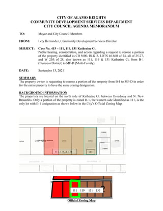
- 1. CITY OF ALAMO HEIGHTS COMMUNITY DEVELOPMENT SERVICES DEPARTMENT CITY COUNCIL AGENDA MEMORANDUM TO: Mayor and City Council Members FROM: Lety Hernandez, Community Development Services Director SUBJECT: Case No. 415 – 111, 119, 131 Katherine Ct. Public hearing, consideration, and action regarding a request to rezone a portion of the property identified as CB 5600, BLK 2, LOTS 46.66ft of 24, all of 25-27, and W 25ft of 28, also known as 111, 119 & 131 Katherine Ct, from B-1 (Business District) to MF-D (Multi-Family). DATE: September 13, 2021 SUMMARY The property owner is requesting to rezone a portion of the property from B-1 to MF-D in order for the entire property to have the same zoning designation. BACKGROUND INFORMATION The properties are located on the north side of Katherine Ct. between Broadway and N. New Braunfels. Only a portion of the property is zoned B-1, the western side identified as 111, is the only lot with B-1 designation as shown below in the City’s Official Zoning Map. Official Zoning Map 111, 119, & 131 135
- 2. POLICY ANALYSIS The proposed zoning change to MF-D would be more restrictive that the current B-1 zoning designation and would be in keeping with surrounding properties. The zoning change would not have an impact on the surrounding properties. On September 07, 2021, the Planning & Zoning Commission considered the request and voted unanimously to recommend approval of the rezone as requested. FISCAL IMPACT No projected fiscal impact from this project has been calculated. ATTACHMENTS Attachment A – Web Packet Attachment B – Postcard Responses ______________________ Lety Hernandez Director ______________________ Buddy Kuhn City Manager
- 3. CITY OF ALAMO HEIGHTS COMMUNITY DEVELOPMENT SERVICES DEPARTMENT 6116 BROADWAY SAN ANTONIO, TX 78209 210-826-0516 Planning & Zoning Commission Tuesday, September 07, 2021 – 5:30 P.M. In accordance with order of the Office of the Governor issued March 16, 2020, where he temporary suspended certain provisions of the Texas Open Meetings Act, take notice that a regular meeting scheduled at 5:30 p.m. on Tuesday, September 07, 2021 will be conducted by telephone conference in order to advance the public health goal of limiting face-to-face meetings (also called “social distancing”), to slow the spread of the Coronavirus (COVID-19), to consider and act upon any lawful subjects which may come before it. Per Governor’s Order GQ-36, attendees are not required to wear facial covering (mask) but they are encouraged. The City will continue to practice social distancing, and seating will be limited. INSTRUCTIONS FOR TELECONFERENCE: The public toll-free dial-in number to participate in the telephonic meeting is 346-248-7799 and enter the access number 89047228116#. Public hearing, consideration, and action will take place on Tuesday, September 07, 2021 at 5:30pm in the Council Chambers of the City of Alamo Heights located at 6116 Broadway St, San Antonio, TX regarding a request to rezone a portion of the property identified as CB 5600, BLK 2, LOTS 46.66ft of 24, all of 25-27, and W 25ft of 28, also known as 111, 119 & 131 Katherine Ct, from B-1 (Business District) to MF-D (Multi-Family). The City Council of the City of Alamo Heights will conduct a public hearing on Monday, September 27, 2021 at 5:30pm in the Council Chambers of the City of Alamo Heights located at 6116 Broadway St, San Antonio, TX relating to the recommendations of the Planning and Zoning Commission regarding the same issues. Attachment A
- 4. Attachment A
- 5. CASTANO AVE 1961 ELLWOOD 998 1141 1757 1968 1462 1635 1642 1965 1755 1001 BROADWAY CASTANO AVE EVANS AVE TUXEDO AVE OGDEN LN CORONA AVE ARGO AVE ARGYLE COLLEGE BLVD LAMONT AVE N NEW BRAUNFELS AVE ABISO AVE PRIMROSE CLAYWELL COLUMBINE ST M O R T O N S T ALTA AVE A U S T I N H W Y PATTERSON AVE E N C IN O A V E NORMANDY AVE NACOGDOCHES RD JOLIET CIRUELA ST ARBUTUS ST WILDROSE AVE ROSEMARY AVE ALBANY ST J O N E S M A L T S B E R G E R R D REDWOOD ST T O R C I D O D R VANDERHOEVEN LOVETA ST CLOVERLEAF AVE A C A C I A CARDINAL AVE MONTCLAIR AVE ELLWOOD E OAKVIEW PLACE WESTOVER RD V IE S C A A V E A S H C R O F T ROUTT ST M O R SE BLUE BONNET BLVD GRANT AVE E O L M O S D R ESTES AVE INSLEE AVE WOODW AY LN BUTTERCUP DR T O W N S E N D A V E WINTERGREEN DR ST DENNIS AVE WILLIM A L L E N S T TERRELL RD GROVE PLACE CLEVELAND CT HARRIGAN CT GREELY ST BARILLA PLACE RETAMA PLACE ARCADIA PLACE B R O N S O N A V E KATHERINE CT DEVINE RD H U B B A R D ST E ELMVIEW PLACE HALCYON PLACE IMLAY ST MARY D AVE LAGOS LN PENNY LN M A Y F L O W E R CANYON E FAIR OAKS PLACE W FAIR OAKS PLACE CRESCENT AVE E EDGEWOOD PLACE EATON ST W ELMVIEW PLACE ST LUKES LN HARRISON AVE ALAM O HEIG HTS BLVD C I R C L E S T AUSWAY LN POCO ST HENDERSON ST C L A I B O R N E W A Y F E N I M O R E K E N N E D Y A V E L A F A Y E T T E J E S S A M I N E S T W EDGEWOOD PLACE W OAKVIEW PLACE ROCKRIDGE LN ALBERTINA LN A L A M O H E I G H T S B L V D IMLAY ST C L E V E L A N D C T E EDGEWOOD PLACE E ELMVIEW PLACE WOODWAY LN L A J A R A B L V D GREELY ST ALTA AVE E FAIR OAKS PLACE C H E S T E R S T ELIZABETH PLACE K A M P M A N N A V E GRANDVIEW PLACE CHICHESTER PLACE MARCIA PLACE KENNEDY AVE CAMBRIDGE OVAL C L E V E L A N D C T HARRISON AVE 0 0 17 9 1 0 12 8 6 156 4 6 3 50 8 11 7 2 197 9 2 8 5 2 9 12 3 3 9 4 3 32 4 9 6 7 21 3 5 22 48 6 1 2 3 7 5 7 2 3 8 73 4 5 1 10 16 15 1 11 52 5 304 11 53 11 21 1 2 12 10 129 10 44 60 43 58 20 40 126 33 13 1 1 29 59 14 192 10 1 27 14 153 17 16 28 16 159 121 17 1 19 200 199 71 191 13 161 13 3 26 146 15 15 14 175 76 11 154 11 7 195 9 61 18 174 117 118 160 19 54 119 19 10 132 134 150 131 12 138 13 125 170 49 12 148 124 136 147 149 203 3 130 193 179 133 151 165 182 137 10 176 172 139 49 169 135 76 77 196 109 115 123 46 155 164 177 7 180 84 47 142 143 201 82 4 77 157 31 122 22 29 20 157 140 23 20 78 66 162 25 78 166 111 167 27 35 110 202 23 84 305 144 152 69 114 178 1 31 68 1 45 24 74 1 168 20 20 22 72 65 116 42 63 57 19 69 79 81 19 11 46 74 65 20 157 70 120 194 163 70 63 80 55 181 1 5 28 55 82 4 75 171 82 42 79 75 74 1 66 81 112 81 72 80 64 85 197 64 145 197 199 56 75 75 2 85 2 64 2 27 199 11 72 15 15 6 174 68 67 64 78 78 174 4 66 66 27 113 121 13 13 71 304 14 13 82 NEW BRAUNFELS AVE £ ¤ 281 CITY OF ALAMO HEIGHTS . 0 0.5 0.25 Miles LEGEND Alamo Heights City Limits Active Specific Use Permit (SUP) & Ordinance # Alamo Heights Zoning Districts 2F-C - Two Family B-1 - Business District B-2 - Business District B-3 - Business District MF-D - Multi-Family O-1 - Office District P - Parking SF-A - Single Family SF-B - Single Family Attachment A Lot 24A to be rezoned to MF-D
- 6. Attachment B
- 7. Attachment B
- 8. Attachment B
- 9. Attachment B
- 10. Attachment B
- 11. Attachment B
- 12. Attachment B
- 13. Attachment B
- 14. Attachment B
- 15. Attachment B
- 16. Attachment B
- 17. Attachment B
- 18. Attachment B
- 19. Attachment B
- 20. Attachment B
- 21. Attachment B
- 22. Attachment B
- 23. Attachment B
- 24. Attachment B