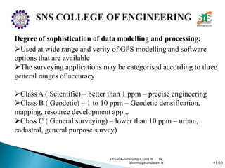
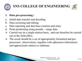
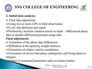
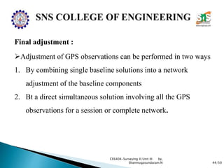
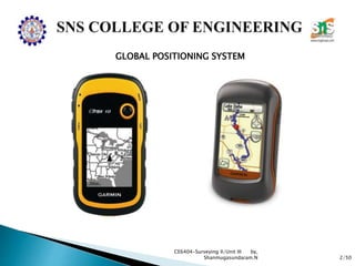
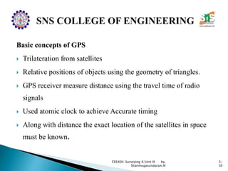
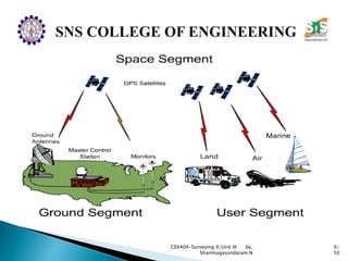
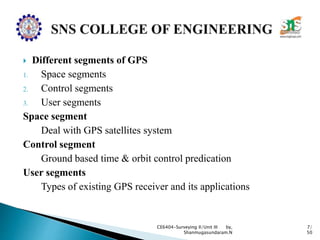
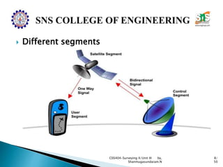
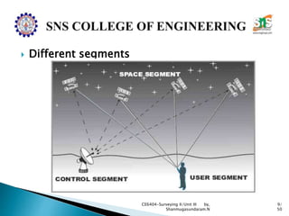
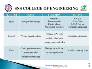
The document discusses the Global Positioning System (GPS). It describes how GPS is a worldwide radio navigation system formed from 24 satellites and their ground stations. It explains the three main segments of GPS: the space segment consisting of the GPS satellites, the control segment which monitors and controls the satellites, and the user segment comprising GPS receivers. It provides details on topics like satellite orbits, signal structure, orbit determination, and different types of GPS receivers.
Edm is a surveying instrument used to measure the distance electronically. This Surveying Instrument is used in triangulation to measure the length of Base line because more accuracy is required to measure the length of base line.
The Global Positioning System is a satellite-based radio navigation system for determination of precise position and time, using radio signals from the satellites, in real-time or in post-processing mode.
Surveying is considered as one of the oldest field of Civil Engineering. As days passes we can see lot of improvements in technology. In this ppt we can able to see latest instruments used for surveying
Global positioning system_Surveying, Civil EngineeringA Makwana
(GPS) technology is a great boon to anyone who has the need to navigate either great or small distances.
The Global Positioning System (GPS) is a burgeoning technology, which provides unequalled accuracy and flexibility of positioning for navigation, surveying and GIS data capture.
GPS World wide navigation and tracking systemarafyghazali
completer description about the historu and invention,developmental stages,architecture,working,advantages,errors,signals,functionality,aims,advancements and future prospects and remedies of solution about global positioning system.GPS
Trajectory estimation studies for long coasting phase of mars missioneSAT Journals
Abstract At Sriharikota range, configuration of down range tracking network, Real-time tracking and trajectory estimation play a critical role during a satellite launch for flight safety as well as mission monitoring. Criticality is more when the mission parameters vary during the launch window to meet the mission requirements. PSLV-C25, the 320 T XL version is intended to inject the 1337.24 Kg MARS Orbiter into 250 Km * 23500 Km * 19.2 deg Sub-GTO orbit. MARS Orbiter Mission [MOM] is the first Indian interplanetary mission to orbit a spacecraft around MARS in an elliptical orbit of 360km * 80000 km. This paper deals with the trajectory estimation and prediction methodologies studied and established at Sriharikota Range for this launch. The major challenge in the Mars orbiter mission is to configure the Down range network of Telemetry stations in view of large variation in the Argument of Perigee (AOP) requirement ranging from 2760 to 2890 during injection over the period of launch window. Requisite AOP facilitates transit of the Spacecraft from Earth to Mars using minimum energy Hohmann transfer. The change in the requirement of AOP each day in turn demanded a new trajectory with its characteristic changes in long coasting duration, fourth stage ignition time and subsequent MARS Orbiter injection time into sub-GTO. It is mandatory to capture the Telemetry data during those critical events to assess the success of the mission. The flight duration was around 3000s and the coasting duration was 1600s before the ignition of the PS4 stage. Study of configuration of mobile Telemetry stations on Ship-borne terminals is carried out to cater to visibility requirements of critical events such as fourth stage ignition time and subsequent MARS Orbiter injection. State vector accuracy studies are carried out for the Ship-borne radar data of the vehicle during long coasting using Linear Kalman filter. Also a trajectory extrapolation algorithm is designed and studied to provide extrapolated trajectory during the long coasting period after 3rd stage burn out which in turn is used to compute and display trajectory parameters to mission executives and provide antenna-pointing information to the ship-borne terminals. This paper presents the trajectory estimation methodology proposed, extrapolation techniques adopted and accuracies achieved for the long coast duration. Keywords: Mars Orbiter Mission (MOM), Flight Safety, Trajectory estimation, Network simulations, Argument of Perigee (AOP).
Global Positioning System (GPS) is the only system today able to show one’s own position on the earth any time in any weather, anywhere. This paper addresses this satellite based navigation system at length. The different segments of GPS viz. space segment, control segment, user segment are discussed. In addition, how this amazing system GPS works, is clearly described. The various errors that degrade the performance of GPS are also included. DIFFERENTIAL GPS, which is used to improve the accuracy of measurements, is also studied. The need, working and implementation of DGPS are discussed at length. Finally, the paper ends with advanced application of GPS.
Strength and durability of concrete - Repair and rehabilitation of structures...Shanmugasundaram N
Quality assurance for concrete – Strength, Durability and Thermal properties, of concrete - Cracks, different types, causes – Effects due to climate, temperature, Sustained elevated temperature, Corrosion - Effects of cover thickness.
Repair, rehabilitation and retrofitting of structures - RRSShanmugasundaram N
Strengthening of Structural elements, Repair of structures distressed due to corrosion, fire, Leakage, earthquake – DEMOLITION TECHNIQUES - Engineered demolition methods - Case studies.
Maintenance and repair strategies - Repair and rehabilitation of structures(RRS)Shanmugasundaram N
Maintenance, Repair and Rehabilitation, Facets of Maintenance, importance of Maintenance, Various aspects of Inspection, Assessment procedure for evaluating a damaged structure, causes of deterioration.
Valuation - Estimation, Costing and Valuation EngineeringShanmugasundaram N
Definitions – Various types of valuations – Valuation methods - Necessity – Capitalised value – Depreciation – Escalation – Valuation of land – Buildings – Calculation of Standard rent – Mortgage – Lease
Contracts - Estimation, Costing and Valuation EngineeringShanmugasundaram N
Contract – Types of contracts – Formation of contract – Contract conditions – Contract for labour, material, design, construction – Drafting of contract documents based on IBRD / MORTH Standard bidding documents – Construction contracts – Contract problems – Arbitration and legal requirements.
Rate analysis and costing - Estimation, Costing and Valuation EngineeringShanmugasundaram N
Standard Data – Observed Data – Schedule of rates – Market rates – Standard Data for Man Hours and Machineries for common civil works – Rate Analysis for all Building works, canals, and Roads– Cost Estimates
Sachpazis:Terzaghi Bearing Capacity Estimation in simple terms with Calculati...Dr.Costas Sachpazis
Terzaghi's soil bearing capacity theory, developed by Karl Terzaghi, is a fundamental principle in geotechnical engineering used to determine the bearing capacity of shallow foundations. This theory provides a method to calculate the ultimate bearing capacity of soil, which is the maximum load per unit area that the soil can support without undergoing shear failure. The Calculation HTML Code included.
Final project report on grocery store management system..pdfKamal Acharya
In today’s fast-changing business environment, it’s extremely important to be able to respond to client needs in the most effective and timely manner. If your customers wish to see your business online and have instant access to your products or services.
Online Grocery Store is an e-commerce website, which retails various grocery products. This project allows viewing various products available enables registered users to purchase desired products instantly using Paytm, UPI payment processor (Instant Pay) and also can place order by using Cash on Delivery (Pay Later) option. This project provides an easy access to Administrators and Managers to view orders placed using Pay Later and Instant Pay options.
In order to develop an e-commerce website, a number of Technologies must be studied and understood. These include multi-tiered architecture, server and client-side scripting techniques, implementation technologies, programming language (such as PHP, HTML, CSS, JavaScript) and MySQL relational databases. This is a project with the objective to develop a basic website where a consumer is provided with a shopping cart website and also to know about the technologies used to develop such a website.
This document will discuss each of the underlying technologies to create and implement an e- commerce website.
Hybrid optimization of pumped hydro system and solar- Engr. Abdul-Azeez.pdffxintegritypublishin
Advancements in technology unveil a myriad of electrical and electronic breakthroughs geared towards efficiently harnessing limited resources to meet human energy demands. The optimization of hybrid solar PV panels and pumped hydro energy supply systems plays a pivotal role in utilizing natural resources effectively. This initiative not only benefits humanity but also fosters environmental sustainability. The study investigated the design optimization of these hybrid systems, focusing on understanding solar radiation patterns, identifying geographical influences on solar radiation, formulating a mathematical model for system optimization, and determining the optimal configuration of PV panels and pumped hydro storage. Through a comparative analysis approach and eight weeks of data collection, the study addressed key research questions related to solar radiation patterns and optimal system design. The findings highlighted regions with heightened solar radiation levels, showcasing substantial potential for power generation and emphasizing the system's efficiency. Optimizing system design significantly boosted power generation, promoted renewable energy utilization, and enhanced energy storage capacity. The study underscored the benefits of optimizing hybrid solar PV panels and pumped hydro energy supply systems for sustainable energy usage. Optimizing the design of solar PV panels and pumped hydro energy supply systems as examined across diverse climatic conditions in a developing country, not only enhances power generation but also improves the integration of renewable energy sources and boosts energy storage capacities, particularly beneficial for less economically prosperous regions. Additionally, the study provides valuable insights for advancing energy research in economically viable areas. Recommendations included conducting site-specific assessments, utilizing advanced modeling tools, implementing regular maintenance protocols, and enhancing communication among system components.
Welcome to WIPAC Monthly the magazine brought to you by the LinkedIn Group Water Industry Process Automation & Control.
In this month's edition, along with this month's industry news to celebrate the 13 years since the group was created we have articles including
A case study of the used of Advanced Process Control at the Wastewater Treatment works at Lleida in Spain
A look back on an article on smart wastewater networks in order to see how the industry has measured up in the interim around the adoption of Digital Transformation in the Water Industry.
Water scarcity is the lack of fresh water resources to meet the standard water demand. There are two type of water scarcity. One is physical. The other is economic water scarcity.
Industrial Training at Shahjalal Fertilizer Company Limited (SFCL)MdTanvirMahtab2
This presentation is about the working procedure of Shahjalal Fertilizer Company Limited (SFCL). A Govt. owned Company of Bangladesh Chemical Industries Corporation under Ministry of Industries.
3. 3/50
CE6404-Surveying II/Unit III by,
Shanmugasundaram.N
GLOBAL POITIONING SYSTEM
World wide radio navigation system
Formed from a constellation of 24 satellites and their ground
stations.
GPS uses satellites as reference point to calculate positions in
meters and also CM
GPS plays a vital in cars, boats, planes, construction equipments,
movie making gears, farm machinery, even laptop computers,
phones etc.....
5. Basic concepts of GPS
Trilateration from satellites
Relative positions of objects using the geometry of triangles.
GPS receiver measure distance using the travel time of radio
signals
Used atomic clock to achieve Accurate timing
Along with distance the exact location of the satellites in space
must be known.
CE6404-Surveying II/Unit III by,
Shanmugasundaram.N
5/
50
7. Different segments of GPS
1. Space segments
2. Control segments
3. User segments
Space segment
Deal with GPS satellites system
Control segment
Ground based time & orbit control predication
User segments
Types of existing GPS receiver and its applications
CE6404-Surveying II/Unit III by,
Shanmugasundaram.N
7/
50
10. SEGMENT INPUT FUNCTION OUTPUT
Space Navigation message
Generate
Transmit code
Carrier phase
Navigation message
P-Code
C/A-Code
L1,L2 Carrier
Navigation message
Control P-Code operation time
Produce GPS time
predict Ephemer is
manage space vehicles
Navigation message
User
Code operation carrier
phase operation
navigation message
Navigation solution
surveying solution
Position velocity time
CE6404-Surveying II/Unit III by,
Shanmugasundaram.N
10
/5
0
11. 11/50
CE6404-Surveying II/Unit III by,
Shanmugasundaram.N
SPACE SEGMENT
Consists of 21 GPS Satellites with an addition of 3 active
spares
Placed in almost 6 circular orbits with an inclination of
55 degree
Orbit height 20200km corresponding to about 26600km
from the semi major axis.
Normal orbit period is 12Hrs.
12. 12/50
CE6404-Surveying II/Unit III by,
Shanmugasundaram.N
SPACE SEGMENT
24 hours global navigation and time determination capacity
Each satellite send a full description of its own orbit and an
approximate guide to orbits of other satellites
Location of a satellites are established by their own orbit
data
Transmitted also health of satellites, parameter for
propagation, error correction Etc,...
13. 13/50
CE6404-Surveying II/Unit III by,
Shanmugasundaram.N
SPACE SEGMENT
GPS satellites divided into 3 types
1. Block 1 – 1 to 11 – 1978 to 1985 – 5 years- development
purpose
2. Block 11 – 28 – 1989 – 5 to 7 years- production satellite
3. Block 11R – 20 satellites – Spare
14. 14/50
CE6404-Surveying II/Unit III by,
Shanmugasundaram.N
CONTROL SEGMENT
Vital link in GPS technology.
Monitoring and controlling the satellite system continuously
Determine GPS system time
Predict the satellite ephemeris and behaviour of each satellite
clock
Update periodically the navigation message for each particular
satellite
15. 15/50
CE6404-Surveying II/Unit III by,
Shanmugasundaram.N
CONTROL SEGMENT
Its consists of
1. Master control station (MCS)
2. Several monitor station (MS)
3. Ground antennas (GA) (All our world)
4. Operation control segments (OCS)
16. 16/50
CE6404-Surveying II/Unit III by,
Shanmugasundaram.N
CONTROL SEGMENT
MCA located in Colorado (USA)
3 MS and GA – Kwajalein, Ascension and Diego Garcia
2 MS in Colorado and Hawaii
Monitor station receives all visible satellite signals by using
antennas.
Antennas are contact to satellite at least 3times per day
automatically.
17. 17/50
CE6404-Surveying II/Unit III by,
Shanmugasundaram.N
USER SEGMENT
Ground station equipments consists of an antenna and a
receiver for surveying purpose.
In small unit(work) using poles and large unit using tripod
over a control station
Transmitted signals are received by the antenna, processed
electronically and passed by the cable to the receiver where
microprocessor reduces the data.
18. 18/50
CE6404-Surveying II/Unit III by,
Shanmugasundaram.N
USER SEGMENT
Method of establish the distance b/n the satellite and receiver
1. Psuedo-range
2. Carrier phase measurement method.
Psuedo-range method
Distance measurement is depends upon accurate time
measurement and precise synchronization of clock in both
satellite and receivers
Its almost impossible to achieve the technique is known as
Psuedo-range.
Satellite continuously transmits its code at every milliseconds
19. 19/50
CE6404-Surveying II/Unit III by,
Shanmugasundaram.N
Psuedo-range method
Due to the travel of signal the receiver received the code
delay and its converted into a distance by multiplying by the
speed of lights
Due to the atmosphere the error will be occurred in speed of
light
Carrier phase measurement method.
Similar to the operational of EDM
Problem creating by two clock
To prevent this problem by taking two reading satellite by
simultaneously and operation by single satellite by two
station.
20. 20/50
CE6404-Surveying II/Unit III by,
Shanmugasundaram.N
Types of GPS
1. Absolute positioning
Single receiver station -50 to 100m accuracy
2. Differential or Relative positioning (DGPS)
Two receiver station – 0.5 to 5m accuracy
3. Real-time kinetic float (RTK float)
More precise-Dual receiver-20cm to 1m accuracy
4. Real-time kinematic fixed (RTK fixed)
Dual receiver- 7 to 5cm-very accuracy
21. 21/50
CE6404-Surveying II/Unit III by,
Shanmugasundaram.N
Signal structure:
One way ranging system
distance is calculated through the knowledge of signal
propagation velocity
clock readings at transmitted and receiver antennas are
compared
Two clocks are not strictly synchronized
The observed signal travel time is biased with systematic
synchronization error.
22. 22/50
CE6404-Surveying II/Unit III by,
Shanmugasundaram.N
Signal structure:
Biased ranges are known as pseudoranges
Need four pseudoranges are necessary to determine X,Y and Z
coordinates of user antenna and clock bias.
Used two different codes p and C/A
P means precision C/A means Clear/acquisition
Satellite have highly precise oscillators with a fundamental
frequency of 10.23 MHz. Its consists of 3 components
23. 23/50
CE6404-Surveying II/Unit III by,
Shanmugasundaram.N
Three components
1. Two micro wave L-band (carrier) waves
L1 carrier : 1574.42 MHz
L2 carrier : 1227.60 MHz
2. Ranging codes modulated on the carrier waves
C/A code modulated at 1.023MHz
degraded code for civilian users modulated on L1
P (Y) code modulated at 10.23 MHz
Authorized military users used both L1 and L2
24. 24/50
CE6404-Surveying II/Unit III by,
Shanmugasundaram.N
3. Navigation message:
Modulated on both L1 and L2 and contains satellite positions
and constants
26. 26/50
CE6404-Surveying II/Unit III by,
Shanmugasundaram.N
Orbit determination (OD) :
process of estimate the position and velocity of a satellite at a
specific epoch based on models of forces acting on the satellite,
integration of satellite orbital motion equations and measurements
to the satellites
1. Preliminary orbit determination (improved as
simplified orbit determination (SOD))
2. Precise orbit determination (POD)
27. 27/50
CE6404-Surveying II/Unit III by,
Shanmugasundaram.N
1.Preliminary orbit determination:
Geometry method to estimate orbit elements from a
minimum set of observations before the orbit is known
from the traditional source.
A. Gaussian orbit determination
Determining the orbital parameters for three sets of
widely spaced direction observations
B. Laplacian orbit determination
To drive the initial velocity at a time instant from
different combination of observation.
Used to find the orbit from different position
28. 28/50
CE6404-Surveying II/Unit III by,
Shanmugasundaram.N
2. Precise orbit determination:
Dynamic or combined geometric and dynamic method, a
process completed with two distinct procedures
Orbit integration
Orbit improvement
Orbit representation:
Representing a satellite orbit as a continuous trajectory
with discrete observation data at the time of interest
Keplerian elements method is simplest orbit
representation- ellipse shape
30. 30/50
CE6404-Surveying II/Unit III by,
Shanmugasundaram.N
Anti- spoofing and selective availability:
In US GPS is a military navigation system, in civilians used
limited accuracy system.
Standard positioning system (SPS) for civilians
Precise positioning service (PPS) for authorized users
SPS accuracy is 100m, 2DRMS and PPS accuracy is 10 to 20m in
3D.
Additional limitation Viz, Anti-spoofing (AS) and selective
availability (SA) was further imposed for civilian users.
31. 31/50
CE6404-Surveying II/Unit III by,
Shanmugasundaram.N
Anti- spoofing and selective availability:
AS only authorized users to get access to the P-code
By imposing SA condition positional accuracy from block II
satellite was randomly offset for SPS users.
Since may 1, 2000 according to declaration of US president SA is
switched off for all users.
32. 32/50
CE6404-Surveying II/Unit III by,
Shanmugasundaram.N
Task of control segment:
Resolves satellite anomalies,
Make pseudo-range and delta-range measurements to determine
satellite clock corrections, almanac and ephemeris
In order to perform the above functions, the control segment is
comprised of three different components
1. Master control station (MCS)
2. Monitor station (MS)
3. Ground antennas
33. 33/50
CE6404-Surveying II/Unit III by,
Shanmugasundaram.N
Task of control segment:
MS tracks the satellite and relay their positions to the master
station.
Used to determine the precise location of satellite constellation.
Accurate atomic clocks on the satellites are also monitored and
compared with the master clock
Each satellite is capable of storing data that would accurately relay
its position for next 14 days via the carrier waves.
Its data bank is updated at every hour by the control station
34. 34/50
CE6404-Surveying II/Unit III by,
Shanmugasundaram.N
Task of control segment :
MS while passing of satellite make pseudo-range and delta-range
measurements.
Measurements are made the two L band frequencies (L1 and L2)
C/A code has a 1 ms period and repeats constantly
P code transmissions is a 7 days sequence
Repeat at every midnight Saturday/Sunday.
Each satellites transmits this frequencies but with different ranging
codes.
35. 35/50
CE6404-Surveying II/Unit III by,
Shanmugasundaram.N
Task of control segment :
Navigation data helps the receiver to determine the location of the
satellite at the time of signal transmission
Ranging code used to determine the satellite time to the users
Used in computer programmes to assist in position solutions.
Receivers:
1. Hand – held receivers
2. Geodetic receivers
3. Single - frequency receivers
4. Dual – frequency receivers
36. 36/50
CE6404-Surveying II/Unit III by,
Shanmugasundaram.N
1. Hand – held receivers
Data recorder which may be capable of tracking up to 6 satellites
Leica MX 8600 series is a typical of this type of equipment.
For differential work use the MX 8650 base station, tracking with
12 satellite
Using mapping by the utilities and local authorities
Base station would be permanently mounted at the office or depot.
37. 37/50
CE6404-Surveying II/Unit III by,
Shanmugasundaram.N
1. Hand – held receivers
1 to 5m accuracy in MX 8601 using pseudo-range measurements
2 cm accuracy in MX 8612 and 8614 use both ranges.
2. Geodetic – receivers
Currently little available
Used in geodetic surveying and precise navigation
Used to start with single frequency C/A code receivers with four
channels
L2 added and tracking capability was increased
38. 38/50
CE6404-Surveying II/Unit III by,
Shanmugasundaram.N
2. Geodetic – receivers
Leading manufacturers have gone for code-less, non sequencing
L2 technique.
WILD/LEITZ (heerbrugg, Switzerland ) and MAGNAVOX
(Torrance, California) have jointly developed WM 101 geodetic
receiver in 1986.
Codes are observed once per seconds
4 channel C/A code receivers
3 channels are track 6 satellites and 4 channels are collect the
satellite messages periodically
39. 39/50
CE6404-Surveying II/Unit III by,
Shanmugasundaram.N
Data processing:
It is most important consideration
Collect the good quality data, for example avoiding multipath
including environments, correct measurement of antenna height,
adequate battery power, no signal observations (tree etc..) or
interference (microwave transmission , etc...) appropriate length
observation sessions, etc...
Repair, detect are appropriately pre-processed.
40. 40/50
CE6404-Surveying II/Unit III by,
Shanmugasundaram.N
Appropriate observation modelling and processing software:
Matched to the accuracy required so that the correct strategy is
used to account for the GPS measurement biases and in particular the
cycle ambiguities
Appropriate processing procedure:
Recognises that GPS phase data reduction involves a numbers of
steps executed in sequence.
41. 41/50
CE6404-Surveying II/Unit III by,
Shanmugasundaram.N
Degree of sophistication of data modelling and processing:
Used at wide range and verity of GPS modelling and software
options that are available
The surveying applications may be categorised according to three
general ranges of accuracy
Class A ( Scientific) – better than 1 ppm – precise engineering
Class B ( Geodetic) – 1 to 10 ppm – Geodetic densification,
mapping, resource development app...
Class C ( General surveying) – lower than 10 ppm – urban,
cadastral, general purpose survey)
42. 42/50
CE6404-Surveying II/Unit III by,
Shanmugasundaram.N
1. Data pre-processing :
a. Initial data transfer and decoding
b. Data screening and editing
c. Data reporting and data base creation and entry
d. Point positioning using pseudo – range data.
Carried out on a single-station basis, and can therefore be carried
out in the field office.
The result should be a set of appropriately formatted and pre-
processed , observations, together with ephemeris information
and approximate station co ordinates
43. 43/50
CE6404-Surveying II/Unit III by,
Shanmugasundaram.N
2. Initial data analysis:
Final data adjustment
Using two or more GPS in field observation
Cycle slip detection and repair
Preliminary baseline solution based on triple – differenced phase
data or double-differenced pseudo-range data
Final adjustment:
Formation of the phase data differences
Definition of the apriority weight matrices
Estimation of relative station coordinates
Estimation of carrier beat phase ambiguities and fixing them to
integers
Output of estimated parameters and covariance matrix
44. 44/50
CE6404-Surveying II/Unit III by,
Shanmugasundaram.N
Final adjustment :
Adjustment of GPS observations can be performed in two ways
1. By combining single baseline solutions into a network
adjustment of the baseline components
2. Bt a direct simultaneous solution involving all the GPS
observations for a session or complete network.
45. 45/50
CE6404-Surveying II/Unit III by,
Shanmugasundaram.N
Traversing and Triangulation:
1. General information
GPS used to other surveying tool
It can accomplish certain goals if we are conscious of its strengths
and limitations.
When surveying with GPS we do not need to have inter-visibility
b/n the stations to measure a baseline.
The only constraint to receive the signals is having a clear of the
sky
46. 46/50
CE6404-Surveying II/Unit III by,
Shanmugasundaram.N
Network design on map:
To make a map of the station in a good geometric figure, both
fixed control points and unknown points for the entire project area.
Scale and distance between the two stations are important factor
Confidence level is not only the accuracy level also the
configuration
To fulfil the basic role a strong and reliable reference frame work,
Its must be homogeneous
Individual figures should be well-shaped
47. 47/50
CE6404-Surveying II/Unit III by,
Shanmugasundaram.N
Network design on map:
Stations should be evenly spaced as possible
Adjacent pairs of stations in the network should preferably be
connected by direct measurement.
Ratio of longest length to the shortest length should never be
greater then 1:5 and usually should be much less
Higher difference in heights b/n two stations will be avoided in the
network
Designed several small closed loops within the large network
48. 48/50
CE6404-Surveying II/Unit III by,
Shanmugasundaram.N
Network design on map:
The areas in which the ground does not permit to design the
network like traverse
There are two types of control
1. Horizontal control
2. Vertical control
Horizontal control
Minimum 3 to 4 fixed control points for average size of project
with complete adjustments
More number of control produce better redundancy with higher
quantity of check
Four control points two at both ends of the network are required
to established for network adjustments
49. 49/50
CE6404-Surveying II/Unit III by,
Shanmugasundaram.N
Vertical control:
MSL height are not to be confused with GPS height
GPS height is based on the WGS 84 ellipsoid
MSL height is based on an equipotential surface coinciding with
MSL called the geoids
Need to know the geoidal undulation at that point for convert the
GPS and MSL height (ex: separation b/n geoid & ellipsoid)
Connect maximum number of points to connect the height and
level adjustments
GPS control points which is not connected with levelling line
will be adjusted by adjustment program with the help of fixed
vertical control points and EGM96 geoid model, used to find
unknown vertical points on to the same datum as fixed point.