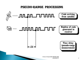
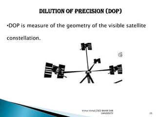
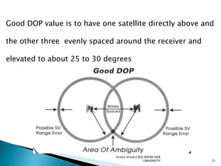
PROCESSING TECHNIQUES

Vrince Vimal,CSED BAHIR DAR
UNIVERSITY

1
PSEUDO-RANGE PROCESSING

Vrince Vimal,CSED BAHIR DAR
UNIVERSITY

2
•It is a measure of the range, or distance, between the
GPS receiver and the GPS satellite

OR
•It is the time shift required to line up a replica of the code

generated in the receiver with the received code from the
satellite multiplied by the speed of light

Vrince Vimal,CSED BAHIR DAR
UNIVERSITY

3
•Either the P-code or the C/A-code can be used
for measuring the pseudo-range
•When the PRN code is transmitted from the satellite,
the receiver generates an exact replica of that code.
•Pseudo-ranges are measured by a correlation detector
that controls a delay lock loop which maintains the
alignment (correlation peak) between the receivergenerated code replica and the actual incoming code
Vrince Vimal,CSED BAHIR DAR
UNIVERSITY

4
•Let the satellite sends a signal at a certain time tsi
•Signal will be received later at time tu
•The distance between the user and the satellite i

Vrince Vimal,CSED BAHIR DAR
UNIVERSITY

5
Carrier-phase measurements

Vrince Vimal,CSED BAHIR DAR
UNIVERSITY

6
•Carrier beat phase is the phase of the signal which
remains when the incoming Doppler-shifted satellite
carrier is differenced (beat) with the constant
frequency generated in the receiver.
•The ranges to the satellites can be obtained through
the carrier phases.
•The precision of carrier beat phase measurements is
much higher than the precision of code pseudo-ranges
Vrince Vimal,CSED BAHIR DAR
UNIVERSITY

7
•There is, however, one problem. The carriers are just
pure sinusoidal waves, which means that all cycles look
the same.
•when it is switched on, cannot determine the total number
of the complete cycles between the satellite and receiver.
It can only measure a fraction of a cycle very accurately
(less than 2 mm),

Vrince Vimal,CSED BAHIR DAR
UNIVERSITY

8
•The initial number of complete cycles remains unknown,
this is known as the initial cycle ambiguity, or the ambiguity

Bias
•If the initial cycle ambiguity parameters are resolved,

accurate range measurements can be obtained,
which lead to accurate position determination

Vrince Vimal,CSED BAHIR DAR
UNIVERSITY

9
Ambiguity-Resolution Techniques
•Centimeter-level positioning accuracy could be achieved
with the carrier-phase observables.

• This requires successful determination of the initial
integer ambiguity parameters, This process is commonly
known as ambiguity resolution.

Vrince Vimal,CSED BAHIR DAR
UNIVERSITY

10
•Earlier high-precision GPS relative positioning with
carrierphase observables was carried out using long
observational time spans (typically a few hours)
•This allows for the receiver-satellite geometry to
change considerably, which helps in separating the
ambiguity parameters from the baseline solution

Vrince Vimal,CSED BAHIR DAR
UNIVERSITY

11
The correct integer values were simply obtained by
rounding off the real-valued numbers to the nearest

Integers.
•But this method is very time consuming.

•To over come this two methods are used:1. Receiver initialization

2. Antenna swap methods

Vrince Vimal,CSED BAHIR DAR
UNIVERSITY

12
Receiver initialization
•If the base line is known, The ambiguity parameters are
determined by simply occupying the two end points of the
known baseline with the base and the rover receivers
for a short period of time.
•Than the rover receiver can move to the points to be
surveyed

Vrince Vimal,CSED BAHIR DAR
UNIVERSITY

13
Antenna swap methods
•It used for a fast and reliable determination of

the initial ambiguity parameters.
•Initially receiver is set over the known point while setting
up the rover within a few meters from it
•About 1-minute simultaneous GPS data is then to be
collected at both receivers.

Vrince Vimal,CSED BAHIR DAR
UNIVERSITY

14
Vrince Vimal,CSED BAHIR DAR
UNIVERSITY

15
•After the data has been collected, the two Antennas are
exchanged.

•With this new setup, another simultaneous 1-minuteGPS
data, at the previous rate, is collected by both receivers.

•Then the receivers are returned to their original setup
•Finally the data is downloaded into the PC processing

software

Vrince Vimal,CSED BAHIR DAR
UNIVERSITY

16
On-the-fly ambiguity resolution
•Initially base and rover measurements are combined in

the double differenced mode and an initial adjustment
•Outcome of this initial adjustment is an initial rover

position along with estimates (real values) for the
ambiguity parameters and their uncertainty values,
or the covariance matrix.

Vrince Vimal,CSED BAHIR DAR
UNIVERSITY

17
Vrince Vimal,CSED BAHIR DAR
UNIVERSITY

18
•This matrix can be represented geometrically to form a
region, known as the confidence region, around the

estimated real-value ambiguity parameter
•The confidence region takes the shape of an ellipse if the
number of the estimated parameters is two, and an
ellipsoid if it is three. For more than three, a
hyperellipsoid is obtained

Vrince Vimal,CSED BAHIR DAR
UNIVERSITY

19
Dilution of Precision (DOP)
•DOP is measure of the geometry of the visible satellite

constellation.

Vrince Vimal,CSED BAHIR DAR
UNIVERSITY

20
Good DOP value is to have one satellite directly above and
the other three evenly spaced around the receiver and

elevated to about 25 to 30 degrees

Vrince Vimal,CSED BAHIR DAR
UNIVERSITY

21
•When the satellites are widely spaced, the overlap area of
the two zones of possible satellite range error is relatively
small, called the “area of positional ambiguity.
•It result in a good, or low Dilution of Precision value.
When the satellites are closely spaced, the overlap area of
the two zones of possible satellite range error is

considerably larger
Vrince Vimal,CSED BAHIR DAR
UNIVERSITY

22
Vrince Vimal,CSED BAHIR DAR
UNIVERSITY

23
The overall GDOP, or Geometric Dilution of Precision
includes:
PDOP, or Precision Dilution of Precision, is the dilution of
precision in three dimensions.

HDOP, or Horizontal Dilution of Precision, is the dilution of
precision in two dimensions horizontally

Vrince Vimal,CSED BAHIR DAR
UNIVERSITY

24
•VDOP, or Vertical Dilution of Precision, is the dilution of
Precision in one dimension, the vertical

•TDOP, or Time Dilution of Precision, is the dilution of
Precision with respect to time.

Vrince Vimal,CSED BAHIR DAR
UNIVERSITY

25
Applications

Vrince Vimal,CSED BAHIR DAR
UNIVERSITY

26
GPS Surveying

Vrince Vimal,CSED BAHIR DAR
UNIVERSITY

27
•Surveying means precision positioning’
•This kind of data collection might include property lines
or construction surveying.
•GPS can survey points in minutes that conventional
surveys might require hours or even days to perform.

Vrince Vimal,CSED BAHIR DAR
UNIVERSITY

28
Geographical positioning

GP means attaching coordinates to objects of interest: e.g.
control monument, gravity data point

Vrince Vimal,CSED BAHIR DAR
UNIVERSITY

29
IMPACT OF GPS ON CONTROL NETWORKS
A control network is a set of monumented points with
Coordinates attached to them
The aim of a control network is to transfer coordinates
to other features, that is, to allow positioning of other
features with respect to the control points.

Vrince Vimal,CSED BAHIR DAR
UNIVERSITY

30
Wt GPS now possible to establish a control point anywhere
without the necessity of having to connect it to already

existing control points through chains of intervisible points.
•the necessity of having any control points at
all is disappearing.

Vrince Vimal,CSED BAHIR DAR
UNIVERSITY

31
Height & Geoid determination

Vrince Vimal,CSED BAHIR DAR
UNIVERSITY

32
•GPS can naturally provide heights and/or height
differences above a selected ellipsoid.

•orthometric heights can be measured accurately by
geometric levelling techniques
However, this is a slow and expensive process a direct
and accurate measure of the geoid can be obtained by

N=h-H.

Vrince Vimal,CSED BAHIR DAR
UNIVERSITY

33
A-4,, Least square methods, Relation positioning,
Ground transportation, orbit determination
climate research

Thank you
Vrince Vimal,CSED BAHIR DAR
UNIVERSITY

34

GPS processing techniques & some applications

  • 1.
  • 2.
  • 3.
    •It is ameasure of the range, or distance, between the GPS receiver and the GPS satellite OR •It is the time shift required to line up a replica of the code generated in the receiver with the received code from the satellite multiplied by the speed of light Vrince Vimal,CSED BAHIR DAR UNIVERSITY 3
  • 4.
    •Either the P-codeor the C/A-code can be used for measuring the pseudo-range •When the PRN code is transmitted from the satellite, the receiver generates an exact replica of that code. •Pseudo-ranges are measured by a correlation detector that controls a delay lock loop which maintains the alignment (correlation peak) between the receivergenerated code replica and the actual incoming code Vrince Vimal,CSED BAHIR DAR UNIVERSITY 4
  • 5.
    •Let the satellitesends a signal at a certain time tsi •Signal will be received later at time tu •The distance between the user and the satellite i Vrince Vimal,CSED BAHIR DAR UNIVERSITY 5
  • 6.
  • 7.
    •Carrier beat phaseis the phase of the signal which remains when the incoming Doppler-shifted satellite carrier is differenced (beat) with the constant frequency generated in the receiver. •The ranges to the satellites can be obtained through the carrier phases. •The precision of carrier beat phase measurements is much higher than the precision of code pseudo-ranges Vrince Vimal,CSED BAHIR DAR UNIVERSITY 7
  • 8.
    •There is, however,one problem. The carriers are just pure sinusoidal waves, which means that all cycles look the same. •when it is switched on, cannot determine the total number of the complete cycles between the satellite and receiver. It can only measure a fraction of a cycle very accurately (less than 2 mm), Vrince Vimal,CSED BAHIR DAR UNIVERSITY 8
  • 9.
    •The initial numberof complete cycles remains unknown, this is known as the initial cycle ambiguity, or the ambiguity Bias •If the initial cycle ambiguity parameters are resolved, accurate range measurements can be obtained, which lead to accurate position determination Vrince Vimal,CSED BAHIR DAR UNIVERSITY 9
  • 10.
    Ambiguity-Resolution Techniques •Centimeter-level positioningaccuracy could be achieved with the carrier-phase observables. • This requires successful determination of the initial integer ambiguity parameters, This process is commonly known as ambiguity resolution. Vrince Vimal,CSED BAHIR DAR UNIVERSITY 10
  • 11.
    •Earlier high-precision GPSrelative positioning with carrierphase observables was carried out using long observational time spans (typically a few hours) •This allows for the receiver-satellite geometry to change considerably, which helps in separating the ambiguity parameters from the baseline solution Vrince Vimal,CSED BAHIR DAR UNIVERSITY 11
  • 12.
    The correct integervalues were simply obtained by rounding off the real-valued numbers to the nearest Integers. •But this method is very time consuming. •To over come this two methods are used:1. Receiver initialization 2. Antenna swap methods Vrince Vimal,CSED BAHIR DAR UNIVERSITY 12
  • 13.
    Receiver initialization •If thebase line is known, The ambiguity parameters are determined by simply occupying the two end points of the known baseline with the base and the rover receivers for a short period of time. •Than the rover receiver can move to the points to be surveyed Vrince Vimal,CSED BAHIR DAR UNIVERSITY 13
  • 14.
    Antenna swap methods •Itused for a fast and reliable determination of the initial ambiguity parameters. •Initially receiver is set over the known point while setting up the rover within a few meters from it •About 1-minute simultaneous GPS data is then to be collected at both receivers. Vrince Vimal,CSED BAHIR DAR UNIVERSITY 14
  • 15.
    Vrince Vimal,CSED BAHIRDAR UNIVERSITY 15
  • 16.
    •After the datahas been collected, the two Antennas are exchanged. •With this new setup, another simultaneous 1-minuteGPS data, at the previous rate, is collected by both receivers. •Then the receivers are returned to their original setup •Finally the data is downloaded into the PC processing software Vrince Vimal,CSED BAHIR DAR UNIVERSITY 16
  • 17.
    On-the-fly ambiguity resolution •Initiallybase and rover measurements are combined in the double differenced mode and an initial adjustment •Outcome of this initial adjustment is an initial rover position along with estimates (real values) for the ambiguity parameters and their uncertainty values, or the covariance matrix. Vrince Vimal,CSED BAHIR DAR UNIVERSITY 17
  • 18.
    Vrince Vimal,CSED BAHIRDAR UNIVERSITY 18
  • 19.
    •This matrix canbe represented geometrically to form a region, known as the confidence region, around the estimated real-value ambiguity parameter •The confidence region takes the shape of an ellipse if the number of the estimated parameters is two, and an ellipsoid if it is three. For more than three, a hyperellipsoid is obtained Vrince Vimal,CSED BAHIR DAR UNIVERSITY 19
  • 20.
    Dilution of Precision(DOP) •DOP is measure of the geometry of the visible satellite constellation. Vrince Vimal,CSED BAHIR DAR UNIVERSITY 20
  • 21.
    Good DOP valueis to have one satellite directly above and the other three evenly spaced around the receiver and elevated to about 25 to 30 degrees Vrince Vimal,CSED BAHIR DAR UNIVERSITY 21
  • 22.
    •When the satellitesare widely spaced, the overlap area of the two zones of possible satellite range error is relatively small, called the “area of positional ambiguity. •It result in a good, or low Dilution of Precision value. When the satellites are closely spaced, the overlap area of the two zones of possible satellite range error is considerably larger Vrince Vimal,CSED BAHIR DAR UNIVERSITY 22
  • 23.
    Vrince Vimal,CSED BAHIRDAR UNIVERSITY 23
  • 24.
    The overall GDOP,or Geometric Dilution of Precision includes: PDOP, or Precision Dilution of Precision, is the dilution of precision in three dimensions. HDOP, or Horizontal Dilution of Precision, is the dilution of precision in two dimensions horizontally Vrince Vimal,CSED BAHIR DAR UNIVERSITY 24
  • 25.
    •VDOP, or VerticalDilution of Precision, is the dilution of Precision in one dimension, the vertical •TDOP, or Time Dilution of Precision, is the dilution of Precision with respect to time. Vrince Vimal,CSED BAHIR DAR UNIVERSITY 25
  • 26.
  • 27.
    GPS Surveying Vrince Vimal,CSEDBAHIR DAR UNIVERSITY 27
  • 28.
    •Surveying means precisionpositioning’ •This kind of data collection might include property lines or construction surveying. •GPS can survey points in minutes that conventional surveys might require hours or even days to perform. Vrince Vimal,CSED BAHIR DAR UNIVERSITY 28
  • 29.
    Geographical positioning GP meansattaching coordinates to objects of interest: e.g. control monument, gravity data point Vrince Vimal,CSED BAHIR DAR UNIVERSITY 29
  • 30.
    IMPACT OF GPSON CONTROL NETWORKS A control network is a set of monumented points with Coordinates attached to them The aim of a control network is to transfer coordinates to other features, that is, to allow positioning of other features with respect to the control points. Vrince Vimal,CSED BAHIR DAR UNIVERSITY 30
  • 31.
    Wt GPS nowpossible to establish a control point anywhere without the necessity of having to connect it to already existing control points through chains of intervisible points. •the necessity of having any control points at all is disappearing. Vrince Vimal,CSED BAHIR DAR UNIVERSITY 31
  • 32.
    Height & Geoiddetermination Vrince Vimal,CSED BAHIR DAR UNIVERSITY 32
  • 33.
    •GPS can naturallyprovide heights and/or height differences above a selected ellipsoid. •orthometric heights can be measured accurately by geometric levelling techniques However, this is a slow and expensive process a direct and accurate measure of the geoid can be obtained by N=h-H. Vrince Vimal,CSED BAHIR DAR UNIVERSITY 33
  • 34.
    A-4,, Least squaremethods, Relation positioning, Ground transportation, orbit determination climate research Thank you Vrince Vimal,CSED BAHIR DAR UNIVERSITY 34