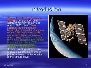
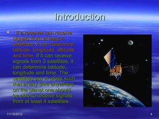
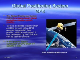
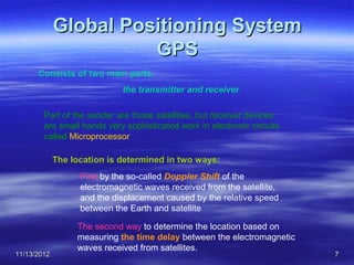
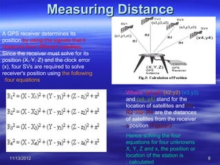
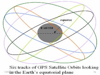
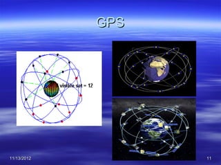
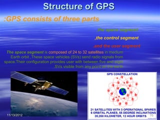
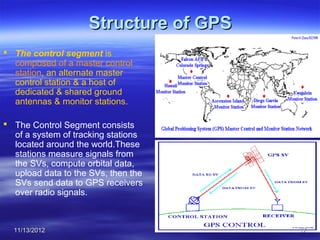
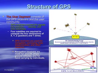
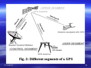
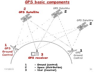
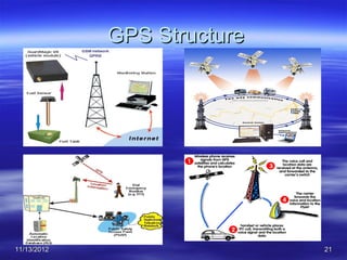
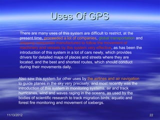
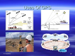
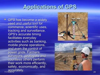
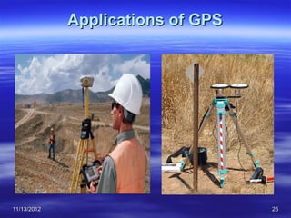
Tanta University
                      Faculty of Science
                    Department of Geology


             Global Positioning System
                       GPS
                       Submitted by
               Mohamed Mahmoud Ahmed El-shora

                       Supervised By
                 Prof. Dr. Shadiya Taha El-khodary
11/13/2012                                           1
Global Positioning System


11/13/2012                          2
Introduction
 Global Positioning System or
  GPS is a constellation of 27
  satellites orbiting the earth at
  about 12000 miles. These
  satellites are continuously
  transmitting a signal and anyone
  with a GPS receiver on earth
  can receive these transmissions
  at no charge. By measuring the
  travel time of signals transmitted
  from each satellite, a GPS
  receiver can calculate its
  distance from the satellite.
  Satellite positions are used by
  receivers as precise reference
  points to determine the location
  of the GPS receiver.


11/13/2012                             3
Introduction
 . If a receiver can receive
  signals from at least 4
  satellites, it can determine
  latitude, longitude, altitude
  and time. If it can receive
  signals from 3 satellites, it
  can determine latitude,
  longitude and time. The
  satellites are in orbits such
  that at any time anywhere
  on the planet one should
  be able to receive signals
  from at least 4 satellites.

11/13/2012                          4
Global Positioning System
                       GPS
 The Global Positioning System
  (GPS) is a space-based global
  navigation satellite system
  (GNSS)
 GPS is a satellite system which
  enables anyone with a GPS
  receiver to establish their
  position, altitude and speed. It
  was developed by the USA and
  can be used by anyone.

 In this picture: Artist's
  conception of GPS Block II-F
  satellite in orbit


                                     GPS Satellite NASA art-ii-f

11/13/2012                                                         5
Comparison of GNSS systems
    System               Country             Number of            Orbital
                                              satellites         height &
                                                                  period
       GPS                 United                 24 ≤           km, 20,200
                           States               (24-32)            12.0h
 COMPASS                    China                  35            km, 21,150
                                                                   12.6h
   GALILEO              European                    22           km, 23,222
                         Union                                     14.1h
  GLONASS                Russia                     24           km, 19,100
                                                                   11.3h
•Core Satellite navigation systems, currently GPS, Galileo and
GLONASS.
 11/13/2012                                                                 6
Global Positioning System
                       GPS
      Consists of two main parts,
                             the transmitter and receiver

        Part of the sender are those satellites, but receiver devices
        are small hands very sophisticated work in electronic circuits
        called Microprocessor

             The location is determined in two ways:
                   First by the so-called Doppler Shift of the
                   electromagnetic waves received from the satellite,
                   and the displacement caused by the relative speed
                   between the Earth and satellite

                  The second way to determine the location based on
                  measuring the time delay between the electromagnetic
                  waves received from satellites.
11/13/2012                                                               7
Measuring Distance
A GPS receiver determines its
position by using the signals that it
observes from different satellites.
Since the receiver must solve for its
position (X, Y, Z) and the clock error
(x), four SVs are required to solve
receiver's position using the following
 :four equations

                                          Where (x1,y1) (x2,y2) (x3,y3)
                                          and (x4, y4) stand for the
                                          location of satellites and R1,
                                          R2, R3, R4 are the distances
                                          of satellites from the receiver
                                          ).position (Figure-3
                                          Hence solving the four
                                          equations for four unknowns
                                          X, Y, Z and x, the position or
   11/13/2012
                                          location of the station is        8
                                          . calculated
Global Positioning System
                  GPS
      The analysis of these data by the GPS devices that contain
      software provider a lot of information and physical variables such
      as the impact the atmosphere on electromagnetic waves, as well
      as the influence of gravity and the situation of climate, as the
      program contains detailed maps of the land, cities and streets,
      where, and the most important geographical features and other
      information important.

      It could be argued that the system of Global Positioning System
      GPS is based on an integrated system of satellites that operate
      within a system called Sophisticated Network Of Satellites, and
      these satellites will scan the globe twice every 23 hours and 56
      minutes, as distributed these satellites on 6 levels of rotation of
      each level makes 55 degrees with the other level, and in each level
      there are three satellites.

11/13/2012                                                                  9
11/13/2012   10
GPS


11/13/2012         11
Models for GPS


11/13/2012                    12
Models for GPS


11/13/2012                    13
GPS MAP


11/13/2012             14
GPS Maps Of Egypt


11/13/2012                       15
Structure of GPS
:GPS consists of three parts
                                                    ,the space segment
                                                   ,the control segment
                                                  .and the user segment
 The space segment is composed of 24 to 32 satellites in medium
   Earth orbit ,These space vehicles (SVs) send radio signals from
space.Their configuration provides user with between five and eight
                            .SVs visible from any point on the earth


 11/13/2012                                                               16
Structure of GPS
 The control segment is
  composed of a master control
  station, an alternate master
  control station & a host of
  dedicated & shared ground
  antennas & monitor stations.

 The Control Segment consists
  of a system of tracking stations
  located around the world.These
  stations measure signals from
  the SVs, compute orbital data,
  upload data to the SVs, then the
  SVs send data to GPS receivers
  over radio signals.


  11/13/2012                           17
Structure of GPS
 The User Segment consists of
  the GPS receivers and the user
  community.
    – GPS receivers convert SV signals
      into position,    velocity, and
      time estimates.
    – Four satellites are required to
      compute the four dimensions of
      X, Y, Z (position) and T (time).

          GPS receivers are used for
           navigation, surveying, time
           dissemination, and other
           research.

          Navigation receivers are
           made for aircraft, ships,
           ground vehicles, and for
           hand carrying by individuals.


 11/13/2012                                18
11/13/2012   19
11/13/2012   20
GPS Structure


11/13/2012                   21
Uses Of GPS
        There are many uses of this system are difficult to restrict, at the
        present time, proceeded a lot of companies, global transportation and
        shipping companies manufactured to follow the movement of
        machinery and vessels by this system very effective, as has been the
        introduction of this system in a lot of cars newly, which provides
        drivers for detailed maps of places and streets where they are
        located, and the best and shortest routes, which should conduct
        during their movements daily.

       Also saw this system for other uses by the airlines and air navigation
       to guide planes in the sky very precisely, and most recently was the
       introduction of this system in monitoring systems, air and track
       hurricanes, wind and waves raging in the oceans, as used by the
       bodies of scientific research to track migration birds, aquatic and
       forest fire monitoring and movement of icebergs.


11/13/2012                                                                      22
Uses Of GPS


11/13/2012                 23
Applications of GPS

 GPS has become a widely
    used and useful tool for
    commerce, scientific uses,
    tracking and surveillance.
    GPS's accurate timing
    facilitates everyday
    activities such as banking,
    mobile phone operations,
    and even the control of
    power grids. Farmers,
    surveyors, geologists and
    countless others perform
    their work more efficiently,
    safely, economically, and
    accurately.
11/13/2012                          24
Applications of GPS


11/13/2012                         25
11/13/2012   26

Gps( global positioning system) 2010

  • 1.
    Tanta University Faculty of Science Department of Geology Global Positioning System GPS Submitted by Mohamed Mahmoud Ahmed El-shora Supervised By Prof. Dr. Shadiya Taha El-khodary 11/13/2012 1
  • 2.
  • 3.
    Introduction  Global PositioningSystem or GPS is a constellation of 27 satellites orbiting the earth at about 12000 miles. These satellites are continuously transmitting a signal and anyone with a GPS receiver on earth can receive these transmissions at no charge. By measuring the travel time of signals transmitted from each satellite, a GPS receiver can calculate its distance from the satellite. Satellite positions are used by receivers as precise reference points to determine the location of the GPS receiver. 11/13/2012 3
  • 4.
    Introduction  . Ifa receiver can receive signals from at least 4 satellites, it can determine latitude, longitude, altitude and time. If it can receive signals from 3 satellites, it can determine latitude, longitude and time. The satellites are in orbits such that at any time anywhere on the planet one should be able to receive signals from at least 4 satellites. 11/13/2012 4
  • 5.
    Global Positioning System GPS  The Global Positioning System (GPS) is a space-based global navigation satellite system (GNSS)  GPS is a satellite system which enables anyone with a GPS receiver to establish their position, altitude and speed. It was developed by the USA and can be used by anyone.  In this picture: Artist's conception of GPS Block II-F satellite in orbit GPS Satellite NASA art-ii-f 11/13/2012 5
  • 6.
    Comparison of GNSSsystems System Country Number of Orbital satellites height & period GPS United 24 ≤ km, 20,200 States (24-32) 12.0h COMPASS China 35 km, 21,150 12.6h GALILEO European 22 km, 23,222 Union 14.1h GLONASS Russia 24 km, 19,100 11.3h •Core Satellite navigation systems, currently GPS, Galileo and GLONASS. 11/13/2012 6
  • 7.
    Global Positioning System GPS Consists of two main parts, the transmitter and receiver Part of the sender are those satellites, but receiver devices are small hands very sophisticated work in electronic circuits called Microprocessor The location is determined in two ways: First by the so-called Doppler Shift of the electromagnetic waves received from the satellite, and the displacement caused by the relative speed between the Earth and satellite The second way to determine the location based on measuring the time delay between the electromagnetic waves received from satellites. 11/13/2012 7
  • 8.
    Measuring Distance A GPSreceiver determines its position by using the signals that it observes from different satellites. Since the receiver must solve for its position (X, Y, Z) and the clock error (x), four SVs are required to solve receiver's position using the following :four equations Where (x1,y1) (x2,y2) (x3,y3) and (x4, y4) stand for the location of satellites and R1, R2, R3, R4 are the distances of satellites from the receiver ).position (Figure-3 Hence solving the four equations for four unknowns X, Y, Z and x, the position or 11/13/2012 location of the station is 8 . calculated
  • 9.
    Global Positioning System GPS The analysis of these data by the GPS devices that contain software provider a lot of information and physical variables such as the impact the atmosphere on electromagnetic waves, as well as the influence of gravity and the situation of climate, as the program contains detailed maps of the land, cities and streets, where, and the most important geographical features and other information important. It could be argued that the system of Global Positioning System GPS is based on an integrated system of satellites that operate within a system called Sophisticated Network Of Satellites, and these satellites will scan the globe twice every 23 hours and 56 minutes, as distributed these satellites on 6 levels of rotation of each level makes 55 degrees with the other level, and in each level there are three satellites. 11/13/2012 9
  • 10.
  • 11.
  • 12.
  • 13.
  • 14.
  • 15.
    GPS Maps OfEgypt 11/13/2012 15
  • 16.
    Structure of GPS :GPSconsists of three parts ,the space segment ,the control segment .and the user segment The space segment is composed of 24 to 32 satellites in medium Earth orbit ,These space vehicles (SVs) send radio signals from space.Their configuration provides user with between five and eight .SVs visible from any point on the earth 11/13/2012 16
  • 17.
    Structure of GPS The control segment is composed of a master control station, an alternate master control station & a host of dedicated & shared ground antennas & monitor stations.  The Control Segment consists of a system of tracking stations located around the world.These stations measure signals from the SVs, compute orbital data, upload data to the SVs, then the SVs send data to GPS receivers over radio signals. 11/13/2012 17
  • 18.
    Structure of GPS The User Segment consists of the GPS receivers and the user community. – GPS receivers convert SV signals into position, velocity, and time estimates. – Four satellites are required to compute the four dimensions of X, Y, Z (position) and T (time).  GPS receivers are used for navigation, surveying, time dissemination, and other research.  Navigation receivers are made for aircraft, ships, ground vehicles, and for hand carrying by individuals. 11/13/2012 18
  • 19.
  • 20.
  • 21.
  • 22.
    Uses Of GPS There are many uses of this system are difficult to restrict, at the present time, proceeded a lot of companies, global transportation and shipping companies manufactured to follow the movement of machinery and vessels by this system very effective, as has been the introduction of this system in a lot of cars newly, which provides drivers for detailed maps of places and streets where they are located, and the best and shortest routes, which should conduct during their movements daily. Also saw this system for other uses by the airlines and air navigation to guide planes in the sky very precisely, and most recently was the introduction of this system in monitoring systems, air and track hurricanes, wind and waves raging in the oceans, as used by the bodies of scientific research to track migration birds, aquatic and forest fire monitoring and movement of icebergs. 11/13/2012 22
  • 23.
  • 24.
    Applications of GPS GPS has become a widely used and useful tool for commerce, scientific uses, tracking and surveillance. GPS's accurate timing facilitates everyday activities such as banking, mobile phone operations, and even the control of power grids. Farmers, surveyors, geologists and countless others perform their work more efficiently, safely, economically, and accurately. 11/13/2012 24
  • 25.
  • 26.

Editor's Notes

  • #17 يتألف الجى.پى.إس من ثلاث شرائح وهى: شرائح الفضاء، والتحكم، والمستخدم. فشريحة الفضاء تتألف من 24 إلى 32 قمراً صناعياً في المدار الأرضى المتوسط، وهو يتضمن أيضاً القاذفات المطلوبة لإطلاق هذه الأقمار إلى مدارها. وتتألف شريحة التحكم من محطة تحكم رئيسية، ومحطة تحكم رئيسية بديلة، ومضيف للهوائيات الأرضية المهداة والمشتركة، بالإضافة إلى محطات رصد. أما شريحة المستخدم فتتألف من مئات الآلاف من المستخدمين التابعين للجيش الأمريكي وقوات الحلفاء والذين يتمتعون بالخدمة الآمنة " جى.پى.إس التحديد الدقيق للمواقع "، وعشرات الملايين من المستخدمين المدنيين والتجاريين والعلماء الذين يستخدمون خدمة تحديد المواقع القياسى