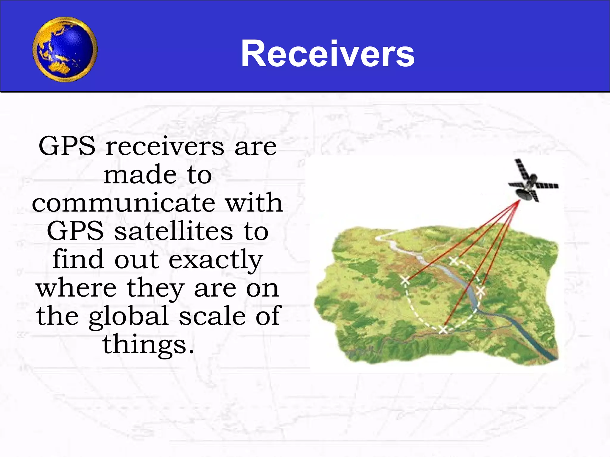
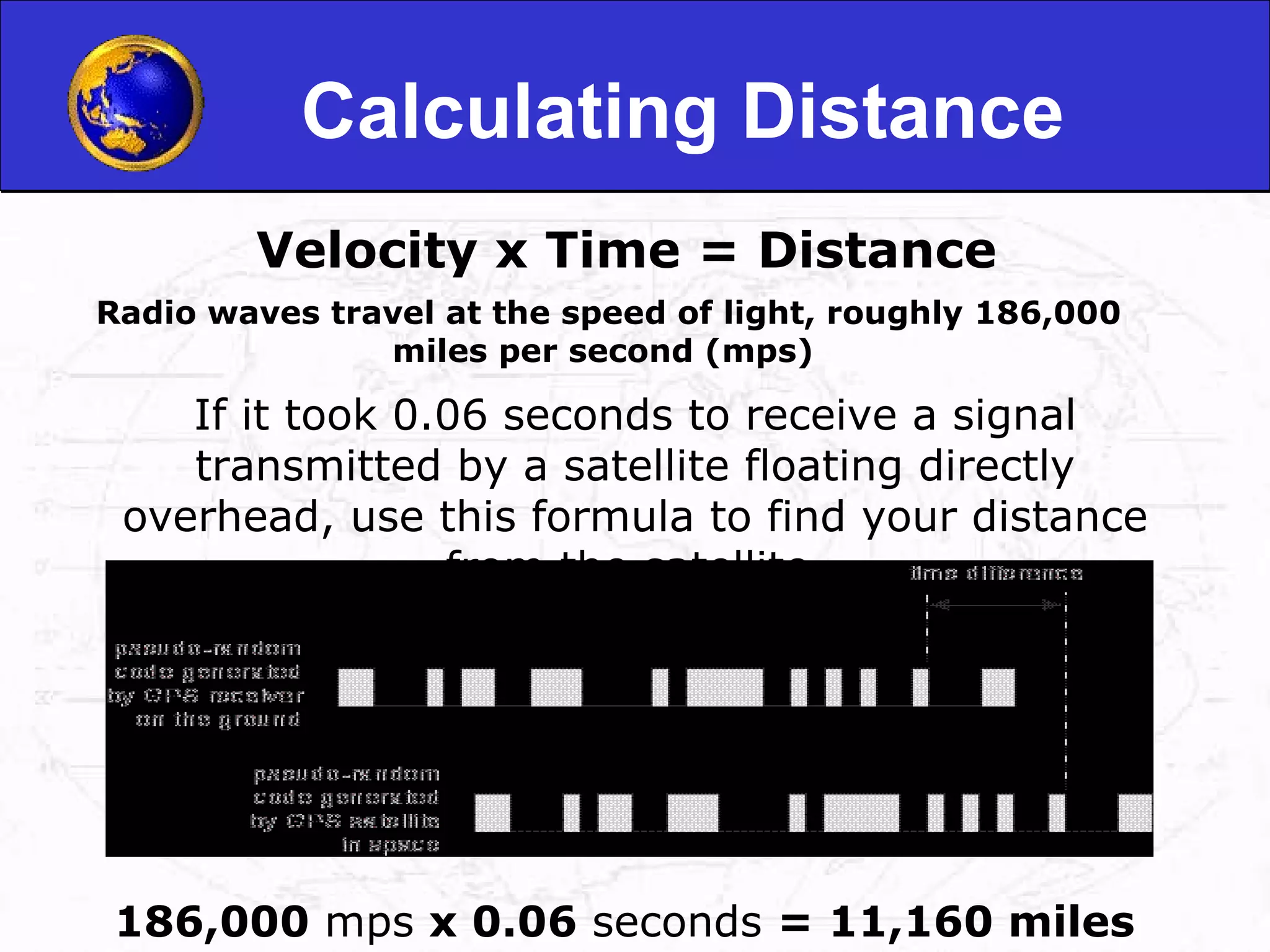
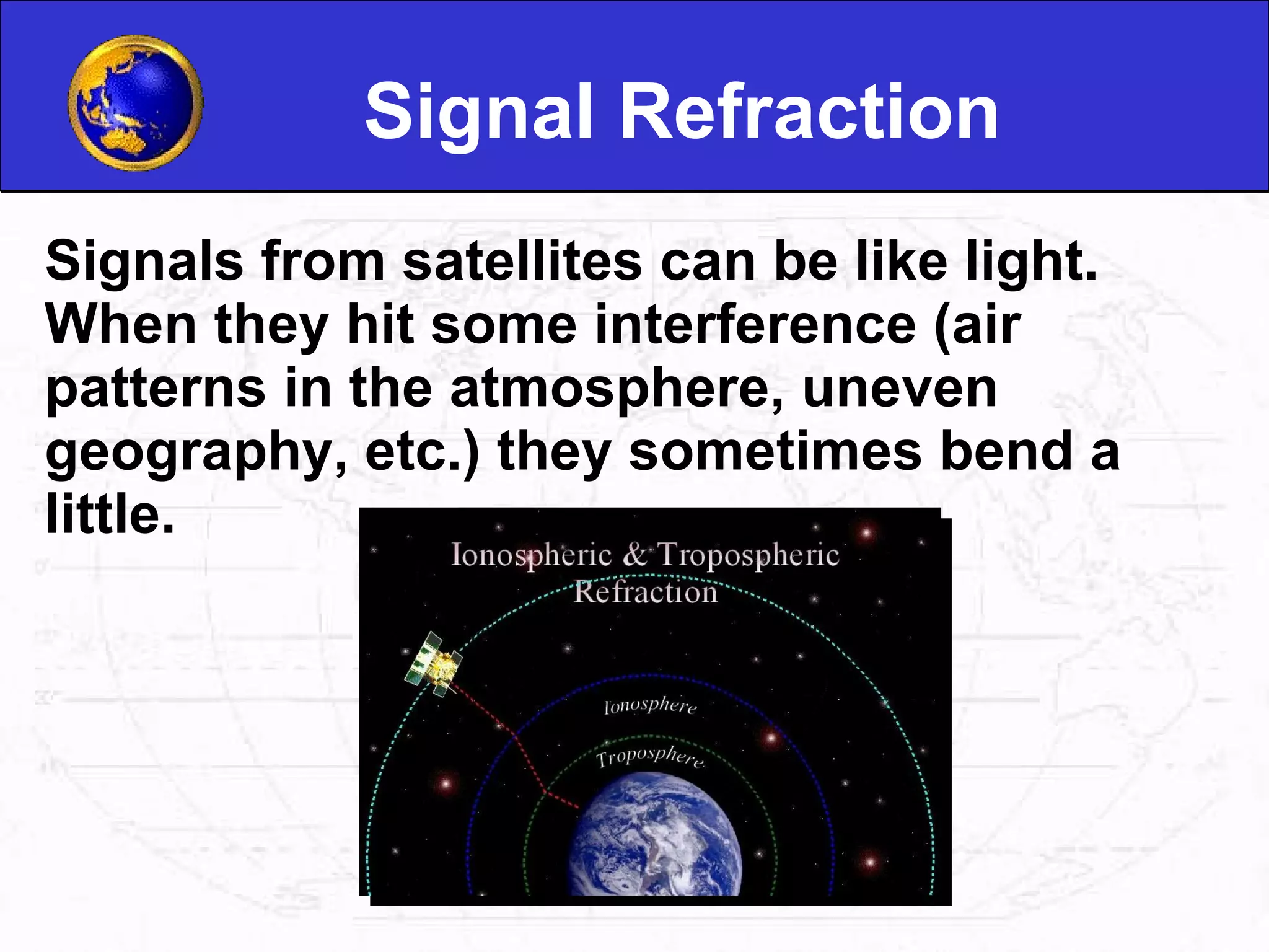
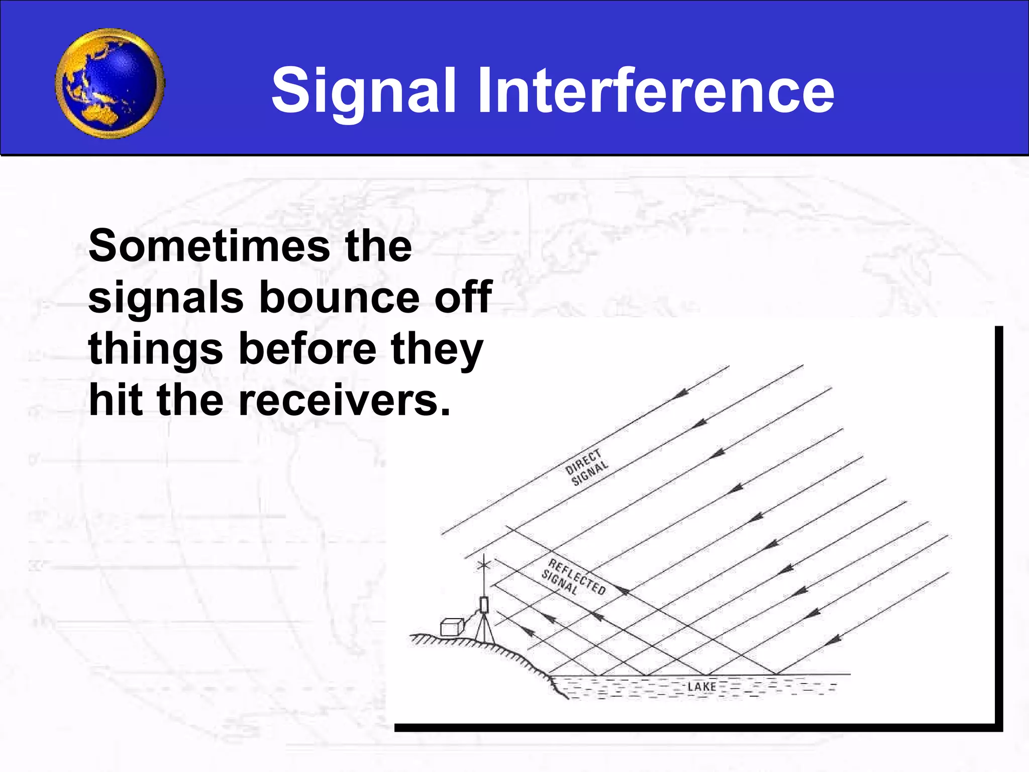
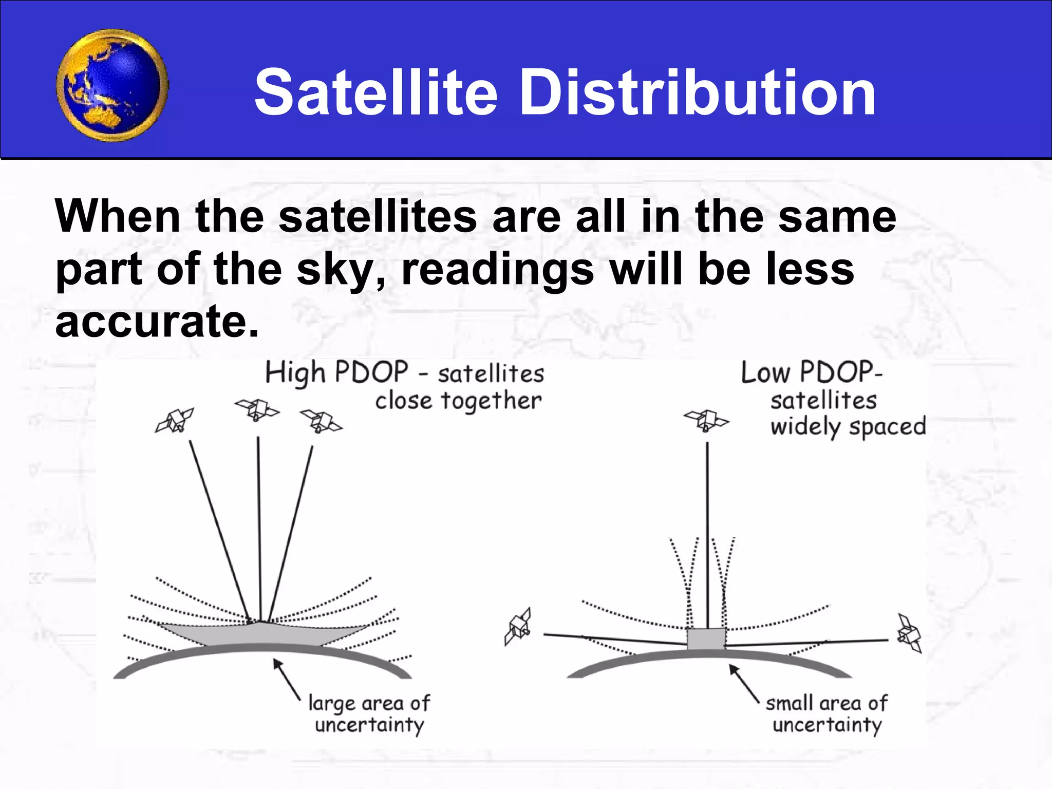
Introduction 1.Koustav bhandari 2.Saswata ghosh 3.Abir pramanik 4.Niladri sekhar dutta 5.Subhra sankha dey Guided by saikat bose
What is GPS? GPS, which stands for Global Positioning System, is the only system today able to show you your exact position on the Earth anytime, in any weather, anywhere.  The three parts of GPS are: GPS Satellites GPS Signals GPS Receivers
Satellites There are quite a number of satellites out there in space.  They are used for a wide range of purposes: satellite TV, cellular phones, military purposes and etc.  Satellites can also be used by GPS receivers.
GPS Satellites There are currently 24 satellites in orbit operated by the US Department of Defense that provide worldwide coverage 24 hours a day, 7 days a week, in all weather.                                                                                                                                   
Satellite System The 24 satellites are orbiting the earth about 12,000 miles above us . They are constantly moving & making 2 complete orbits in less than 24 hours . 55 degrees inclination The travelling speed  is 7000 miles per an hour roughly . The satellites are powered by solar energy & they have back-up batteries .
Some facts about satellites The first GPS satellite was lauched in 1978 A full constellation of 24 satellites was achieved in 1994. Each satellite is built to last about 10 years. A GPS satellite weighs approximately 2,000 pounds and is about 17 feet across with the solar panels extended. Transmitter power is only 50 watts or less. GPS satellites emit continuous navigation signal
GPS Signals Each GPS satellite transmits data that indicates its location and the current time. All GPS satellites synchronize operations so that these repeating signals are transmitted at the same instant.  Physically the signal is just a complicated digital code, or in other words, a complicated sequence of “on” and “off” pulses.
GPS Signals Properties Civilian GPS uses the L1 frequency of 1575.42 MHz in the UHF band . The signals travel by line of sight . A GPS signal contains three different bits of information . A pseudorandom code Ephemeris data Almanac data
GPS signals errors Ionosphere and troposphere delays Signal multipath Receiver clock errors Orbital errors Number of satellites visible Satellite geometry/shading  Intentional degradation of the satellite signal
Receivers GPS receivers are made to communicate with GPS satellites to find out exactly where they are on the global scale of things.
Various types of Receivers cars mobile pad watch
Time Difference The GPS receiver compares the time a signal was transmitted by a satellite with the time it was received. The time difference tells the GPS receiver how far away the satellite is.
Calculating Distance Velocity x Time = Distance   Radio waves travel at the speed of light, roughly 186,000 miles per second (mps)  If it took 0.06 seconds to receive a signal transmitted by a satellite floating directly overhead, use this formula to find your distance from the satellite. 186,000  mps  x 0.06  seconds  = 11,160 miles
Tracking It is the process of monitoring object when it moves along
DGPS Differential GPS uses position corrections to attain greater accuracy by the use of a reference station. When a station knows what it's precise location is it can compare that position with the signals from the GPS satellites
Step 123
100 meter resolution
30 meter resolution
5 meter resolution
Waypoints Waypoints are locations or landmarks that can be stored in your GPS.  Waypoints may be defined and stored in the unit manually by inputting latitude and longitude from a map or other reference.  Latitude and Longitude Your location Direction of waypoint Date and Time Waypoint
Data Dictionary GPS units collect data in: Points Lines Areas These are called features. A data dictionary is a means by which we collect specific information about a data feature.
Shortcomings Line of Sight Transmissions Signal Refraction Signal Interference Satellite Distribution
Line of Sight Transmissions Line of sight is the ability to draw a straight line between two objects without any other objects getting in the way.  GPS transmission are line-of-sight transmissions. Obstructions such as trees, buildings, or natural formations may prevent clear line of sight.
Light Refraction Sometimes the GPS signal from the satellite doesn’t follow a straight line.  Refraction is the bending of light as it travels through one media to another.
Signal Refraction Signals from satellites can be like light. When they hit some interference (air patterns in the atmosphere, uneven geography, etc.) they sometimes bend a little.
Signal Interference Sometimes the signals bounce off things before they hit the receivers.
Satellite Distribution When the satellites are all in the same part of the sky, readings will be less accurate.
Applications Agriculture Aviation Marine Rail Road & Highway Public safety Space Surveying & mapping Timing Recreation Environment
Agriculture Farm planning Field mapping Soil sampling Tractor guidance Crops scouting
Aviation determination for all phases of flight from departure, en route, and arrival New and more efficient air routes made possible by GPS
Marine Search & rescue Accurate method to navigate Measuring speed Determine the location
Rail Improves safety & security Helps to reduce accidents , delays, operating cost Real time position information
Latitude and Longitude Latitude and Longitude are spherical coordinates on the surface of the earth. Latitude is measured North or South of the Equator. Longitude is measured East or West of Greenwich
Thanks you!

Gps Niladri

  • 1.
    Introduction 1.Koustav bhandari2.Saswata ghosh 3.Abir pramanik 4.Niladri sekhar dutta 5.Subhra sankha dey Guided by saikat bose
  • 2.
    What is GPS?GPS, which stands for Global Positioning System, is the only system today able to show you your exact position on the Earth anytime, in any weather, anywhere. The three parts of GPS are: GPS Satellites GPS Signals GPS Receivers
  • 3.
    Satellites There arequite a number of satellites out there in space. They are used for a wide range of purposes: satellite TV, cellular phones, military purposes and etc. Satellites can also be used by GPS receivers.
  • 4.
    GPS Satellites Thereare currently 24 satellites in orbit operated by the US Department of Defense that provide worldwide coverage 24 hours a day, 7 days a week, in all weather.                                                                                                                                  
  • 5.
    Satellite System The24 satellites are orbiting the earth about 12,000 miles above us . They are constantly moving & making 2 complete orbits in less than 24 hours . 55 degrees inclination The travelling speed is 7000 miles per an hour roughly . The satellites are powered by solar energy & they have back-up batteries .
  • 6.
    Some facts aboutsatellites The first GPS satellite was lauched in 1978 A full constellation of 24 satellites was achieved in 1994. Each satellite is built to last about 10 years. A GPS satellite weighs approximately 2,000 pounds and is about 17 feet across with the solar panels extended. Transmitter power is only 50 watts or less. GPS satellites emit continuous navigation signal
  • 7.
    GPS Signals EachGPS satellite transmits data that indicates its location and the current time. All GPS satellites synchronize operations so that these repeating signals are transmitted at the same instant. Physically the signal is just a complicated digital code, or in other words, a complicated sequence of “on” and “off” pulses.
  • 8.
    GPS Signals PropertiesCivilian GPS uses the L1 frequency of 1575.42 MHz in the UHF band . The signals travel by line of sight . A GPS signal contains three different bits of information . A pseudorandom code Ephemeris data Almanac data
  • 9.
    GPS signals errorsIonosphere and troposphere delays Signal multipath Receiver clock errors Orbital errors Number of satellites visible Satellite geometry/shading  Intentional degradation of the satellite signal
  • 10.
    Receivers GPS receiversare made to communicate with GPS satellites to find out exactly where they are on the global scale of things.
  • 11.
    Various types ofReceivers cars mobile pad watch
  • 12.
    Time Difference TheGPS receiver compares the time a signal was transmitted by a satellite with the time it was received. The time difference tells the GPS receiver how far away the satellite is.
  • 13.
    Calculating Distance Velocityx Time = Distance Radio waves travel at the speed of light, roughly 186,000 miles per second (mps) If it took 0.06 seconds to receive a signal transmitted by a satellite floating directly overhead, use this formula to find your distance from the satellite. 186,000 mps x 0.06 seconds = 11,160 miles
  • 14.
    Tracking It isthe process of monitoring object when it moves along
  • 15.
    DGPS Differential GPSuses position corrections to attain greater accuracy by the use of a reference station. When a station knows what it's precise location is it can compare that position with the signals from the GPS satellites
  • 16.
  • 17.
  • 18.
  • 19.
  • 20.
    Waypoints Waypoints arelocations or landmarks that can be stored in your GPS. Waypoints may be defined and stored in the unit manually by inputting latitude and longitude from a map or other reference. Latitude and Longitude Your location Direction of waypoint Date and Time Waypoint
  • 21.
    Data Dictionary GPSunits collect data in: Points Lines Areas These are called features. A data dictionary is a means by which we collect specific information about a data feature.
  • 22.
    Shortcomings Line ofSight Transmissions Signal Refraction Signal Interference Satellite Distribution
  • 23.
    Line of SightTransmissions Line of sight is the ability to draw a straight line between two objects without any other objects getting in the way. GPS transmission are line-of-sight transmissions. Obstructions such as trees, buildings, or natural formations may prevent clear line of sight.
  • 24.
    Light Refraction Sometimesthe GPS signal from the satellite doesn’t follow a straight line. Refraction is the bending of light as it travels through one media to another.
  • 25.
    Signal Refraction Signalsfrom satellites can be like light. When they hit some interference (air patterns in the atmosphere, uneven geography, etc.) they sometimes bend a little.
  • 26.
    Signal Interference Sometimesthe signals bounce off things before they hit the receivers.
  • 27.
    Satellite Distribution Whenthe satellites are all in the same part of the sky, readings will be less accurate.
  • 28.
    Applications Agriculture AviationMarine Rail Road & Highway Public safety Space Surveying & mapping Timing Recreation Environment
  • 29.
    Agriculture Farm planningField mapping Soil sampling Tractor guidance Crops scouting
  • 30.
    Aviation determination forall phases of flight from departure, en route, and arrival New and more efficient air routes made possible by GPS
  • 31.
    Marine Search &rescue Accurate method to navigate Measuring speed Determine the location
  • 32.
    Rail Improves safety& security Helps to reduce accidents , delays, operating cost Real time position information
  • 33.
    Latitude and LongitudeLatitude and Longitude are spherical coordinates on the surface of the earth. Latitude is measured North or South of the Equator. Longitude is measured East or West of Greenwich
  • 34.

Editor's Notes

  • #8 Signal chosen because: The complex pattern ensures that the receiver does not accidentally synchronize up to some other signal or so the receiver won’t accidentally pick up another satellite’s signal
  • #13 Working principal
  • #21 Or more usually, waypoints may be entered directly by taking a reading with the unit at the location itself, giving it a name, and then saving the point.
  • #24 drawbacks
  • #28 PDOP = Positional Dilution of Precision
  • #34 GPS uses Latitudes and Longitudes to reference locations.