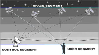
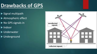
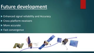
Group Members,
1. Arslan Ikram
2. Hassan Rohail
3. Talha Noman
4. Anas Ali
History of GPS
By Hassan Rohail
History
 The Global Positioning System (GPS) was designed for
military applications. Its primary purpose was to
allow soldiers to keep track of their position and to
assist in guiding weapons to their targets.
 The satellites were built by Rockwell International
and were launched by the U.S. Air Force.
 The entire system is funded by the U.S. government
and controlled by the U.S. Department of Defense.
The total cost for implementing the system was over
$12 billion
History
 The GPS project was developed in 1973 to
overcome the limitations of previous navigation
systems.
 The GPS constellation of satellites consists of at
least 24 satellites – 21 primary satellites and 3
orbiting spares.
 It became fully operational in 1995,and became
public in 2000.
 The inventors of GPS are Bradford Parkinson, Roger
L. Easton, and Ivan A. Getting.
WHAT IS GPS ?
BY TALHA NOMAN
What is GPS ?
 A space-based navigation system that provides
1. location,
2. information about weather
3. navigation.
 It mainly consists of three segments,
1. Space segment
2. Control segment
3. User Segment
GPS Elements
 Space Segment
 GPS satellites fly in circular orbits at an altitude of
20,200 km with a period of 12 hours.
 Orbits are designed so that, six satellites are always
within line of sight from any location on the planet.
 Control Segment
 Operated by US Air Force
 Master control segment
 Dedicated ground antennas
 Monitoring stations
GPS Elements
 User Segment
 Consists of Gps Recivers
 Calculate location using Gps Signals
Working of GPS
BY ANAS ALI
Applications, Drawbacks and Future
Development
By Arslan Ikram
Applications of GPS
 Aviation
 Cost effective solution
 Increase the and efficiency
 Three-dimensional positioning
Applications of GPS
 Space
 Nacigation Solutions
 Altitude Solutions
 Timing Solutions & etc.
Applications of GPS
 Survey and Mapping
 Accuracy
 Reliability
 Interoperability
Drawbacks of GPS
 Signal multipath
 Atmospheric effect
 No GPS signals in
 Indoor
 Underwater
 Underground
Future development
 Enhanced signal reliability and Accuracy
 Cross platform receivers
 More accurate
 Fast convergence
Future developments
 GLONASS – Russia's global navigation system. Fully operational worldwide.
 Galileo – a global system being developed by the European Union and
other partner countries, which began operation in 2016, and is expected to
be fully deployed by 2020.
 Beidou – People's Republic of China's regional system, currently limited to
Asia and the West Pacific, global coverage planned to be operational by
2020
 IRNSS - A regional navigation system developed by the Indian Space
Research Organization.
 QZSS - A regional navigation system in development that would be
receivable within Japan.
Global positioning system(GPS)

Global positioning system(GPS)

  • 3.
    Group Members, 1. ArslanIkram 2. Hassan Rohail 3. Talha Noman 4. Anas Ali
  • 4.
    History of GPS ByHassan Rohail
  • 5.
    History  The GlobalPositioning System (GPS) was designed for military applications. Its primary purpose was to allow soldiers to keep track of their position and to assist in guiding weapons to their targets.  The satellites were built by Rockwell International and were launched by the U.S. Air Force.  The entire system is funded by the U.S. government and controlled by the U.S. Department of Defense. The total cost for implementing the system was over $12 billion
  • 6.
    History  The GPSproject was developed in 1973 to overcome the limitations of previous navigation systems.  The GPS constellation of satellites consists of at least 24 satellites – 21 primary satellites and 3 orbiting spares.  It became fully operational in 1995,and became public in 2000.  The inventors of GPS are Bradford Parkinson, Roger L. Easton, and Ivan A. Getting.
  • 7.
    WHAT IS GPS? BY TALHA NOMAN
  • 8.
    What is GPS?  A space-based navigation system that provides 1. location, 2. information about weather 3. navigation.  It mainly consists of three segments, 1. Space segment 2. Control segment 3. User Segment
  • 9.
    GPS Elements  SpaceSegment  GPS satellites fly in circular orbits at an altitude of 20,200 km with a period of 12 hours.  Orbits are designed so that, six satellites are always within line of sight from any location on the planet.  Control Segment  Operated by US Air Force  Master control segment  Dedicated ground antennas  Monitoring stations
  • 10.
    GPS Elements  UserSegment  Consists of Gps Recivers  Calculate location using Gps Signals
  • 11.
  • 15.
    Applications, Drawbacks andFuture Development By Arslan Ikram
  • 16.
    Applications of GPS Aviation  Cost effective solution  Increase the and efficiency  Three-dimensional positioning
  • 17.
    Applications of GPS Space  Nacigation Solutions  Altitude Solutions  Timing Solutions & etc.
  • 18.
    Applications of GPS Survey and Mapping  Accuracy  Reliability  Interoperability
  • 19.
    Drawbacks of GPS Signal multipath  Atmospheric effect  No GPS signals in  Indoor  Underwater  Underground
  • 20.
    Future development  Enhancedsignal reliability and Accuracy  Cross platform receivers  More accurate  Fast convergence
  • 21.
    Future developments  GLONASS– Russia's global navigation system. Fully operational worldwide.  Galileo – a global system being developed by the European Union and other partner countries, which began operation in 2016, and is expected to be fully deployed by 2020.  Beidou – People's Republic of China's regional system, currently limited to Asia and the West Pacific, global coverage planned to be operational by 2020  IRNSS - A regional navigation system developed by the Indian Space Research Organization.  QZSS - A regional navigation system in development that would be receivable within Japan.