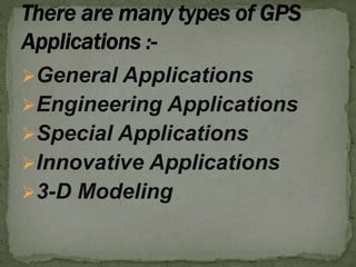
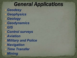
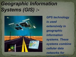
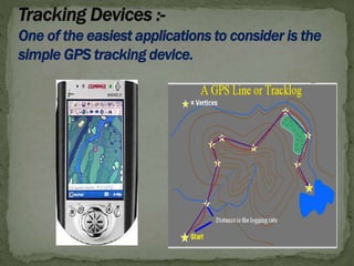
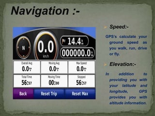
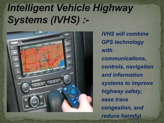
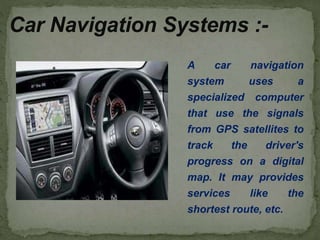
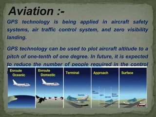
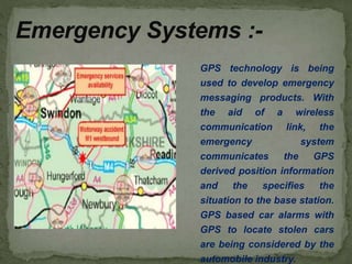
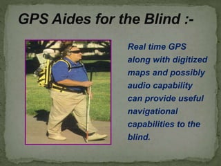
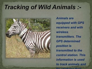
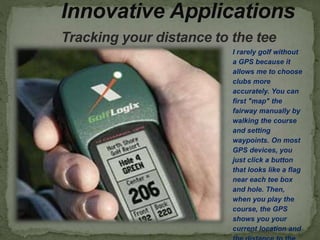
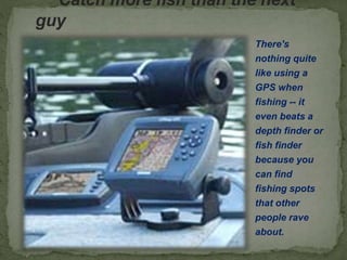
PRESENTED BY. :– DHARMENDRA
MEENA
(U13CE105)
General Applications
Engineering Applications
Special Applications
Innovative Applications
3-D Modeling
Geodesy
Geophysics
Geology
Geodynamics
GIS
Control surveys
Aviation
Military and Police
Navigation
Time Transfer
Mining
Local planning
Recreation
Public Safety
Business
Environmental resource agents
Surveying and Mapping
Entertainment and Recreation
Research
Weather forecasting
Orbit determination
 General navigation in high seas
 Research in oceanography
 Position and Velocity
 Calibration of transponder systems
 Positioning of underwater sources in Marine
 Precise Hydrographic Surveying
 Monitoring silt accretion and erosion in rivers , lakes
 Real time dredge guidance and control
 Coastal Engineering
 Attitude control of ships , buoys
 Marine Geodynamics
Surveying for preparation of mines plans
Connection of mines pipes to National Datum
and Grid
Tracking and Monitoring of heavy equipment
Precise positioning of drill equipment
Tracking of materials and vehicles
Calculate surface to surface volume
Navigation of Vehicles
Design and Construction of Roads
Proximity Warning system
 Enroute Navigation
 Low level Navigation
 Target acquisition
 Photo reconnaissance
 Remotely operated vehicles
 Sensor emplacement
 Missile guidance
 Command and Control
 Monitoring nuclear detonations
 Precise bombing
 Updating inertial navigation systems
GPS technology
is used
extensively in
geographic
information
systems. These
systems combine
cellular data
networks for
Geographic Information
Systems (GIS) :-
 Speed:-
GPS’s calculate your
ground speed as
you walk, run, drive
or fly.
 Elevation:-
In addition to
providing you with
your latitude and
longitude, GPS
provides you with
altitude information.
Navigation :-
IVHS will combine
GPS technology
with
communications,
controls, navigation
and information
systems to improve
highway safety,
ease trace
congestion, and
reduce harmful
Intelligent Vehicle Highway
Systems (IVHS) :-
A car navigation
system uses a
specialized computer
that use the signals
from GPS satellites to
track the driver's
progress on a digital
map. It may provides
services like the
shortest route, etc.
Car Navigation Systems :-
GPS technology is being applied in aircraft safety
systems, air traffic control system, and zero visibility
landing.
GPS technology can be used to plot aircraft altitude to a
pitch of one-tenth of one degree. In future, it is expected
to reduce the number of people required in the control
tower and cockpit.
Aviation :-
1) Determination of Control Points for : -
 Cartography
 GIS
 Photogrammetric
 Remote Sensing
 Geophysical Surveys
 Inertial Surveys
 Hydrographical Surveys
 Expeditions of all kinds
 Archeological mapping
 Large-scale Surveys and Mapping
Ground subsidence or rise
Land slides
Deformation and Construction of Dams
Subsidence of offshore structure
Settlement of buildings
Tunnel Surveys /construction
Bridge construction
Road Surveys /construction
Pipe lines
Power and communication lines
Waterways
Canal and Drain Surveys
Particle accelerators
 Construction vehicles
 Dumpers and excavations in open pit
mining
 Taxi fleet management
 Transport vehicles and cars
Forklifts in open storage areas
Railroad corridor Surveying
Pesticides spraying and seed control in
Agricultural
Forest management
Vehicle Tracking
Glacial Geodesy
Attitude control of Aircrafts and Ships
Global maritime Distress and Safety
system
Efficient flight routes
Improvement in transport efficiency
Enhance Safety
Map making and charting
Water Quality data mapped using sensor
Study animal Behavior
Search and Rescue operations
Environmental study
Earthquake prediction
Finding out height of Mount Everest
Police to Track and catch criminals
Landing and Approach of Aircrafts
Fleet management
In synchronizing communications network
Keystone to National and International
infrastructure
GPS technology is being
used to develop emergency
messaging products. With
the aid of a wireless
communication link, the
emergency system
communicates the GPS
derived position information
and the specifies the
situation to the base station.
GPS based car alarms with
GPS to locate stolen cars
are being considered by the
automobile industry.
Emergency Systems :-
GPS Aides for the Blind :-
Real time GPS
along with digitized
maps and possibly
audio capability
can provide useful
navigational
capabilities to the
blind.
Tracking of Wild Animals :-
Animals are
equipped with GPS
receivers and with
wireless
transmitters. The
GPS determined
position is
transmitted to the
control station. This
information is used
to track animals and
Innovative Applications
Tracking your distance to the tee
I rarely golf without
a GPS because it
allows me to choose
clubs more
accurately. You can
first "map" the
fairway manually by
walking the course
and setting
waypoints. On most
GPS devices, you
just click a button
that looks like a flag
near each tee box
and hole. Then,
when you play the
course, the GPS
shows you your
current location and
Catch more fish than the next
guy
There's
nothing quite
like using a
GPS when
fishing -- it
even beats a
depth finder or
fish finder
because you
can find
fishing spots
that other
people rave
about.
Hunt for buried treasure with your co-
workers
Geocaching
involves
using a GPS
that you
load with
coordinates,
and then
finding a
buried
treasure in
parks and
other public
places.
Go for a hike, run, walk or bike ride and never
get lost
Biking with
a GPS
allows you
to not only
find a route,
but monitor
your heart
rate and
track your
distance.
Find your way around town
Car navigation
makes sense
for anyone
who travels for
business, or
for team-
building events
where
employees
must complete
tasks around
town.
Improving Agriculture
Monitoring Vehicle Usage
Tracking Endangered Species
Tracking Children and Elderly Individuals
Real-world Gaming
Google Maps for Mobile
Doggy GPS
Near Air Quality Monitoring
GPS with Physiological sensors for Runners
Find coffee shops, Wi-Fi hot spots, libraries
or just about any public place
 3-D Vehicle system
GPS Smart Shoes to help Track Alzheimer’s
suffer
Oakley GPS Glasses help Cyclist’s Improve
performance
GPS to Track Soccer player’s Performance
Water Vapour Monitoring for Weather
Forecasts
Three-dimensional (3D) modeling in transportation
construction is a mature technology that serves as the
building block for the modern-day digital jobsite. The
technology allows for faster, more accurate and more
efficient planning and construction.
3-D Modeling
OS Model Builder :-
Evaluate the risks and costs
of projects
Improve the speed of
informed decision making
Provide clients with stunning
visual representations
Keep the project delivery
team and the supply chain
New 3D Modelling application to
save money and time :-
Develop Digital Terrain Models (DTM)
Produce Accurate 3-D plan Drawings
Exact Location of Project
Higher Accuracy of finished grades
Reduced fuel consumption
Extended workday
Reduced potential for Re-work
 Accelerated schedule and increased
productivity
Accurately Estimate material Quantities
and Project costs
Gps application

Gps application

  • 1.
    PRESENTED BY. :–DHARMENDRA MEENA (U13CE105)
  • 2.
    General Applications Engineering Applications SpecialApplications Innovative Applications 3-D Modeling
  • 3.
  • 4.
    Local planning Recreation Public Safety Business Environmentalresource agents Surveying and Mapping Entertainment and Recreation Research Weather forecasting Orbit determination
  • 5.
     General navigationin high seas  Research in oceanography  Position and Velocity  Calibration of transponder systems  Positioning of underwater sources in Marine  Precise Hydrographic Surveying  Monitoring silt accretion and erosion in rivers , lakes  Real time dredge guidance and control  Coastal Engineering  Attitude control of ships , buoys  Marine Geodynamics
  • 6.
    Surveying for preparationof mines plans Connection of mines pipes to National Datum and Grid Tracking and Monitoring of heavy equipment Precise positioning of drill equipment Tracking of materials and vehicles Calculate surface to surface volume Navigation of Vehicles Design and Construction of Roads Proximity Warning system
  • 7.
     Enroute Navigation Low level Navigation  Target acquisition  Photo reconnaissance  Remotely operated vehicles  Sensor emplacement  Missile guidance  Command and Control  Monitoring nuclear detonations  Precise bombing  Updating inertial navigation systems
  • 8.
    GPS technology is used extensivelyin geographic information systems. These systems combine cellular data networks for Geographic Information Systems (GIS) :-
  • 10.
     Speed:- GPS’s calculateyour ground speed as you walk, run, drive or fly.  Elevation:- In addition to providing you with your latitude and longitude, GPS provides you with altitude information. Navigation :-
  • 11.
    IVHS will combine GPStechnology with communications, controls, navigation and information systems to improve highway safety, ease trace congestion, and reduce harmful Intelligent Vehicle Highway Systems (IVHS) :-
  • 12.
    A car navigation systemuses a specialized computer that use the signals from GPS satellites to track the driver's progress on a digital map. It may provides services like the shortest route, etc. Car Navigation Systems :-
  • 13.
    GPS technology isbeing applied in aircraft safety systems, air traffic control system, and zero visibility landing. GPS technology can be used to plot aircraft altitude to a pitch of one-tenth of one degree. In future, it is expected to reduce the number of people required in the control tower and cockpit. Aviation :-
  • 14.
    1) Determination ofControl Points for : -  Cartography  GIS  Photogrammetric  Remote Sensing  Geophysical Surveys  Inertial Surveys  Hydrographical Surveys  Expeditions of all kinds  Archeological mapping  Large-scale Surveys and Mapping
  • 15.
    Ground subsidence orrise Land slides Deformation and Construction of Dams Subsidence of offshore structure Settlement of buildings
  • 16.
    Tunnel Surveys /construction Bridgeconstruction Road Surveys /construction Pipe lines Power and communication lines Waterways Canal and Drain Surveys Particle accelerators
  • 17.
     Construction vehicles Dumpers and excavations in open pit mining  Taxi fleet management  Transport vehicles and cars Forklifts in open storage areas
  • 18.
    Railroad corridor Surveying Pesticidesspraying and seed control in Agricultural Forest management Vehicle Tracking Glacial Geodesy Attitude control of Aircrafts and Ships Global maritime Distress and Safety system Efficient flight routes Improvement in transport efficiency Enhance Safety Map making and charting
  • 19.
    Water Quality datamapped using sensor Study animal Behavior Search and Rescue operations Environmental study Earthquake prediction Finding out height of Mount Everest Police to Track and catch criminals Landing and Approach of Aircrafts Fleet management In synchronizing communications network Keystone to National and International infrastructure
  • 20.
    GPS technology isbeing used to develop emergency messaging products. With the aid of a wireless communication link, the emergency system communicates the GPS derived position information and the specifies the situation to the base station. GPS based car alarms with GPS to locate stolen cars are being considered by the automobile industry. Emergency Systems :-
  • 21.
    GPS Aides forthe Blind :- Real time GPS along with digitized maps and possibly audio capability can provide useful navigational capabilities to the blind.
  • 22.
    Tracking of WildAnimals :- Animals are equipped with GPS receivers and with wireless transmitters. The GPS determined position is transmitted to the control station. This information is used to track animals and
  • 23.
    Innovative Applications Tracking yourdistance to the tee I rarely golf without a GPS because it allows me to choose clubs more accurately. You can first "map" the fairway manually by walking the course and setting waypoints. On most GPS devices, you just click a button that looks like a flag near each tee box and hole. Then, when you play the course, the GPS shows you your current location and
  • 24.
    Catch more fishthan the next guy There's nothing quite like using a GPS when fishing -- it even beats a depth finder or fish finder because you can find fishing spots that other people rave about.
  • 25.
    Hunt for buriedtreasure with your co- workers Geocaching involves using a GPS that you load with coordinates, and then finding a buried treasure in parks and other public places.
  • 26.
    Go for ahike, run, walk or bike ride and never get lost Biking with a GPS allows you to not only find a route, but monitor your heart rate and track your distance.
  • 27.
    Find your wayaround town Car navigation makes sense for anyone who travels for business, or for team- building events where employees must complete tasks around town.
  • 28.
    Improving Agriculture Monitoring VehicleUsage Tracking Endangered Species Tracking Children and Elderly Individuals Real-world Gaming Google Maps for Mobile Doggy GPS Near Air Quality Monitoring GPS with Physiological sensors for Runners
  • 29.
    Find coffee shops,Wi-Fi hot spots, libraries or just about any public place  3-D Vehicle system GPS Smart Shoes to help Track Alzheimer’s suffer Oakley GPS Glasses help Cyclist’s Improve performance GPS to Track Soccer player’s Performance Water Vapour Monitoring for Weather Forecasts
  • 30.
    Three-dimensional (3D) modelingin transportation construction is a mature technology that serves as the building block for the modern-day digital jobsite. The technology allows for faster, more accurate and more efficient planning and construction. 3-D Modeling
  • 31.
    OS Model Builder:- Evaluate the risks and costs of projects Improve the speed of informed decision making Provide clients with stunning visual representations Keep the project delivery team and the supply chain New 3D Modelling application to save money and time :-
  • 32.
    Develop Digital TerrainModels (DTM) Produce Accurate 3-D plan Drawings Exact Location of Project Higher Accuracy of finished grades Reduced fuel consumption Extended workday Reduced potential for Re-work  Accelerated schedule and increased productivity Accurately Estimate material Quantities and Project costs