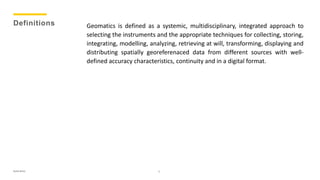
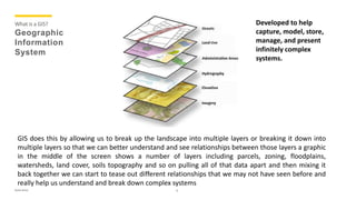
Presented by,
Rohit Bisht
(Masters in Oil and Gas Management)
GEOMATICS
Rohit Bisht 1
Definitions
2
Geomatics is defined as a systemic, multidisciplinary, integrated approach to
selecting the instruments and the appropriate techniques for collecting, storing,
integrating, modelling, analyzing, retrieving at will, transforming, displaying and
distributing spatially georeferenaced data from different sources with well-
defined accuracy characteristics, continuity and in a digital format.
Rohit Bisht
Disciplines
and
Techniques
Constituting
Geomatics
Computer science: to represent and process applicable information through the
development of technological instruments (i.e. hardware) and of methods, models
and systems (i.e. software).
Geodesy: to determine the shape and size of the Earth; it defines on the one hand the
surface of reference in its complete form, the geoid, as well as in its simplified form,
the ellipsoid, and on the other hand the external gravitational field as a function of
time.
Topography: started with and part of geodesy, this is a combination of procedures for
direct land survey. Topography is a combination of methods and instruments to
comprehensively measure and represent details of the Earth’s surface:
• Planimetry: to determine the relative positions of the representation of points
on the Earth’s surface with respect to the same reference surface;
• Altimetry: to determine the height of the points on the Earth’s surface with
respect to the geoid surface;
• Tachymetry: for the planimetric and altimetric survey of the Earth’s surface
zones;
• Land surveying: to measure areas, moving and rectify borders, levelling zones
of the Earth physical surface.
3Rohit Bisht
Disciplines
and
Techniques
Constituting
Geomatics
(cont.)
Cartography: to supply a possible description of the shape and dimension of the
Earth and its natural and artificial details, by means of graphical or numerical
representation of more or less wide areas, following fixed rules.
Photogrammetry: to determine the position and shapes of the objects by measuring
them on photographic images.
Remote Sensing: to remotely acquire territorial and environmental data and to
combine methods and techniques for subsequent processing and interpretation (this
definition also fits digital photogrammetry).
Global Positioning System (GPS): to provide the three-dimensional (3D) position of
fixed or moving objects, in space and time, all over the Earth’s surface, under any
meteorological conditions and in real time.
Laser scanning system: to locate objects and measure their distance by means of the
incident radiation in the optical frequencies (0.3–15 μm) of the electromanetic
spectrum.
4Rohit Bisht
Disciplines
and
Techniques
Constituting
Geomatics
(cont.)
Geographical Information System (GIS): to make use of a powerful combination of
instruments capable of receiving, recording, recalling, transforming, representing and
processing georeferenced spatial data.
Decision Support System (DSS): to implement complex Geographical Information
Systems, meant to create possible scenarios by modelling the ground truth and to
offer a set of solutions to the decision maker.
Expert System (ES): to consider instruments capable of imitating the experts’
cognitive processes and their ability to manage the complexity of reality by means of
interdependent processes of abstraction, generalization and approximation.
WebGIS: to distribute geographic data remotely stored on dedicated machines for
databases, according to complex network architectures.
Ontology: to specify a conceptuality, i.e. the description of concepts and relation-
ships existing for an element or among various elements of a group, entity or class;
conceptualization is an abstract simplified vision of the world to be represented for a
given application.
5Rohit Bisht
Knowing
“Where”
is
Important
Why:
Path: What path the hurricane is
taking ?
Evacuations: How the evacuation
should take place, what route should
be taken ?
Damage: What is the total damage ?
Utilities: Which utilities have been
impacted and how we replace or fix or
get those utilities back online to
minimize the impact on the populous ?
Since almost everything happens
somewhere, knowing where that
something happens is critical
For example, Hurricane Irene:
6Rohit Bisht
Thinking
Spatially
Dr. John Snow “Father” of
Epidemiology
and Spatial Analysis (1813-1858)
7Rohit Bisht
What is a GIS?
Geographic
Information
System
Developed to help
capture, model, store,
manage, and present
infinitely complex
systems.
8
GIS does this by allowing us to break up the landscape into multiple layers or breaking it down into
multiple layers so that we can better understand and see relationships between those layers a graphic
in the middle of the screen shows a number of layers including parcels, zoning, floodplains,
watersheds, land cover, soils topography and so on pulling all of that data apart and then mixing it
back together we can start to tease out different relationships that we may not have seen before and
really help us understand and break down complex systems
Rohit Bisht
GIS Data
Spatial
Data
Spatial Data have unique geographic coordinates that allow the data to be
located in geographic space.
9
Now we use spatial data in everyday life, whenever
• we open google maps we are using spatial data, every time you look at your phone and open an app
it generally use some sort of spatial data.
• Credit card the company know where you are
• Navigation system uses spatial data.Rohit Bisht
GIS Data
Non-
Spatial
Data
Spatial Data typically has associated non-spatial data that describes the
event or object
10
Attribute Data (non-spatial)
Type Color LastFix FlowRat
e (gpm)
Repair
Fire
Hydrate
Red 6/23/02 200 No
Rohit Bisht
GIS Data
Models
Vector Raster
Vector data are discrete
representations of
geospatial features
modeled as coordinate
pairs (x,y points)
connected by lines.
Raster data represent geospatial
features (or phenomenon) through
a series of grid cells or pixels
11Rohit Bisht
GIS Data Models
12
Data Models can represent
 Houses, transportation networks, building footprints
and parcels arc can be vector data sets
 While Raster data sets can represent elevation, aerial
photo, population density per sqr. mile
Rohit Bisht
GIS Applications in
Petroleum
Exploration
Exploration requires the analysis of a lot of different types of data such as
satellite imagery, digital aerial photo mosaics, seismic surveys, surface geology
studies, subsurface and cross section interpretations and images, well
locations, and existing infrastructure information. A GIS can tie these data
together to the location in question and allow you to overlay, view, and
manipulate the data in the form of a map to thoroughly analyze the potential
for finding new potential. Geologists, geophysicists, engineers and petro-
physicists usually perform exploration evaluation.
13Rohit Bisht
Coordinate
System
A system that uses coordinates to establish position, a method of
representing features in a space of given dimensions by coordinates
from an origin
14
Coordinate system is related to the real world through a datum and the datum provides a relationship of
the coordinate system to the real world. The earth is not a sphere. It is irregular in shape thus making
calculating the coordinates and altitudes a lot difficult. The earth shape or geoid and the reference point
used in map preparation is called datum. A common horizontal datum in US is the North American datum
of 1983.
Thus map makers or topographers or GIS chose the datum for the area they are mapping. The first thing
is to select the ellipsoid and then selecting the most appropriate mapping of the spherical coordinate
system onto the selected ellipsoid.
Reference mostly used is the Geographic Coordinate system = Longitude and latitude represents angels
and Prime meridian and equator are the reference plains used to define this angel, any point on the earth
surface can be represented using longitude and latitude. Prime Meridian is the royal observatory,
Greenwich (England) also known as International Date Line (IDL)Rohit Bisht
Geodetic Datum
 A reference datum is a known and constant surface which is used to
describe the location of unknown points on the earth.
 Horizontal datum's are used for describing a point on the earth’s
surface, in latitude and longitude or another coordinate system.
 Vertical datum's measures elevations or depths
15
Current use of GIS and GPS software has increase the awareness of storing the datum and ellipsoid for
Longitude and latitude. Knowing the datum and ellipsoid that your longitude and latitude has been stored
in, can make a big difference in the position of the feature. If the get data that was collected World
geodetic Datum(WGS84) and you tell the GIS that the data has been stored in north America datum
(NAD27) then it will show the position in the wrong location. Geographic coordinate stored in Longitude
and latitude angels Can be projected in other coordinate system so here comes ArcGIS are tool box to
perform this task.
Rohit Bisht
ArcGIS
16
ArcGIS Desktop: two primary modules (MS only)
 Arc Map: For data display, map production, spatial analysis, data
editing
 Arc Catalog: For data management and preview
 Arc Toolbox: For specialized data conversions and analyses,
available as a window in both
Rohit Bisht

Geomatics

  • 1.
    Presented by, Rohit Bisht (Mastersin Oil and Gas Management) GEOMATICS Rohit Bisht 1
  • 2.
    Definitions 2 Geomatics is definedas a systemic, multidisciplinary, integrated approach to selecting the instruments and the appropriate techniques for collecting, storing, integrating, modelling, analyzing, retrieving at will, transforming, displaying and distributing spatially georeferenaced data from different sources with well- defined accuracy characteristics, continuity and in a digital format. Rohit Bisht
  • 3.
    Disciplines and Techniques Constituting Geomatics Computer science: torepresent and process applicable information through the development of technological instruments (i.e. hardware) and of methods, models and systems (i.e. software). Geodesy: to determine the shape and size of the Earth; it defines on the one hand the surface of reference in its complete form, the geoid, as well as in its simplified form, the ellipsoid, and on the other hand the external gravitational field as a function of time. Topography: started with and part of geodesy, this is a combination of procedures for direct land survey. Topography is a combination of methods and instruments to comprehensively measure and represent details of the Earth’s surface: • Planimetry: to determine the relative positions of the representation of points on the Earth’s surface with respect to the same reference surface; • Altimetry: to determine the height of the points on the Earth’s surface with respect to the geoid surface; • Tachymetry: for the planimetric and altimetric survey of the Earth’s surface zones; • Land surveying: to measure areas, moving and rectify borders, levelling zones of the Earth physical surface. 3Rohit Bisht
  • 4.
    Disciplines and Techniques Constituting Geomatics (cont.) Cartography: to supplya possible description of the shape and dimension of the Earth and its natural and artificial details, by means of graphical or numerical representation of more or less wide areas, following fixed rules. Photogrammetry: to determine the position and shapes of the objects by measuring them on photographic images. Remote Sensing: to remotely acquire territorial and environmental data and to combine methods and techniques for subsequent processing and interpretation (this definition also fits digital photogrammetry). Global Positioning System (GPS): to provide the three-dimensional (3D) position of fixed or moving objects, in space and time, all over the Earth’s surface, under any meteorological conditions and in real time. Laser scanning system: to locate objects and measure their distance by means of the incident radiation in the optical frequencies (0.3–15 μm) of the electromanetic spectrum. 4Rohit Bisht
  • 5.
    Disciplines and Techniques Constituting Geomatics (cont.) Geographical Information System(GIS): to make use of a powerful combination of instruments capable of receiving, recording, recalling, transforming, representing and processing georeferenced spatial data. Decision Support System (DSS): to implement complex Geographical Information Systems, meant to create possible scenarios by modelling the ground truth and to offer a set of solutions to the decision maker. Expert System (ES): to consider instruments capable of imitating the experts’ cognitive processes and their ability to manage the complexity of reality by means of interdependent processes of abstraction, generalization and approximation. WebGIS: to distribute geographic data remotely stored on dedicated machines for databases, according to complex network architectures. Ontology: to specify a conceptuality, i.e. the description of concepts and relation- ships existing for an element or among various elements of a group, entity or class; conceptualization is an abstract simplified vision of the world to be represented for a given application. 5Rohit Bisht
  • 6.
    Knowing “Where” is Important Why: Path: What paththe hurricane is taking ? Evacuations: How the evacuation should take place, what route should be taken ? Damage: What is the total damage ? Utilities: Which utilities have been impacted and how we replace or fix or get those utilities back online to minimize the impact on the populous ? Since almost everything happens somewhere, knowing where that something happens is critical For example, Hurricane Irene: 6Rohit Bisht
  • 7.
    Thinking Spatially Dr. John Snow“Father” of Epidemiology and Spatial Analysis (1813-1858) 7Rohit Bisht
  • 8.
    What is aGIS? Geographic Information System Developed to help capture, model, store, manage, and present infinitely complex systems. 8 GIS does this by allowing us to break up the landscape into multiple layers or breaking it down into multiple layers so that we can better understand and see relationships between those layers a graphic in the middle of the screen shows a number of layers including parcels, zoning, floodplains, watersheds, land cover, soils topography and so on pulling all of that data apart and then mixing it back together we can start to tease out different relationships that we may not have seen before and really help us understand and break down complex systems Rohit Bisht
  • 9.
    GIS Data Spatial Data Spatial Datahave unique geographic coordinates that allow the data to be located in geographic space. 9 Now we use spatial data in everyday life, whenever • we open google maps we are using spatial data, every time you look at your phone and open an app it generally use some sort of spatial data. • Credit card the company know where you are • Navigation system uses spatial data.Rohit Bisht
  • 10.
    GIS Data Non- Spatial Data Spatial Datatypically has associated non-spatial data that describes the event or object 10 Attribute Data (non-spatial) Type Color LastFix FlowRat e (gpm) Repair Fire Hydrate Red 6/23/02 200 No Rohit Bisht
  • 11.
    GIS Data Models Vector Raster Vectordata are discrete representations of geospatial features modeled as coordinate pairs (x,y points) connected by lines. Raster data represent geospatial features (or phenomenon) through a series of grid cells or pixels 11Rohit Bisht
  • 12.
    GIS Data Models 12 DataModels can represent  Houses, transportation networks, building footprints and parcels arc can be vector data sets  While Raster data sets can represent elevation, aerial photo, population density per sqr. mile Rohit Bisht
  • 13.
    GIS Applications in Petroleum Exploration Explorationrequires the analysis of a lot of different types of data such as satellite imagery, digital aerial photo mosaics, seismic surveys, surface geology studies, subsurface and cross section interpretations and images, well locations, and existing infrastructure information. A GIS can tie these data together to the location in question and allow you to overlay, view, and manipulate the data in the form of a map to thoroughly analyze the potential for finding new potential. Geologists, geophysicists, engineers and petro- physicists usually perform exploration evaluation. 13Rohit Bisht
  • 14.
    Coordinate System A system thatuses coordinates to establish position, a method of representing features in a space of given dimensions by coordinates from an origin 14 Coordinate system is related to the real world through a datum and the datum provides a relationship of the coordinate system to the real world. The earth is not a sphere. It is irregular in shape thus making calculating the coordinates and altitudes a lot difficult. The earth shape or geoid and the reference point used in map preparation is called datum. A common horizontal datum in US is the North American datum of 1983. Thus map makers or topographers or GIS chose the datum for the area they are mapping. The first thing is to select the ellipsoid and then selecting the most appropriate mapping of the spherical coordinate system onto the selected ellipsoid. Reference mostly used is the Geographic Coordinate system = Longitude and latitude represents angels and Prime meridian and equator are the reference plains used to define this angel, any point on the earth surface can be represented using longitude and latitude. Prime Meridian is the royal observatory, Greenwich (England) also known as International Date Line (IDL)Rohit Bisht
  • 15.
    Geodetic Datum  Areference datum is a known and constant surface which is used to describe the location of unknown points on the earth.  Horizontal datum's are used for describing a point on the earth’s surface, in latitude and longitude or another coordinate system.  Vertical datum's measures elevations or depths 15 Current use of GIS and GPS software has increase the awareness of storing the datum and ellipsoid for Longitude and latitude. Knowing the datum and ellipsoid that your longitude and latitude has been stored in, can make a big difference in the position of the feature. If the get data that was collected World geodetic Datum(WGS84) and you tell the GIS that the data has been stored in north America datum (NAD27) then it will show the position in the wrong location. Geographic coordinate stored in Longitude and latitude angels Can be projected in other coordinate system so here comes ArcGIS are tool box to perform this task. Rohit Bisht
  • 16.
    ArcGIS 16 ArcGIS Desktop: twoprimary modules (MS only)  Arc Map: For data display, map production, spatial analysis, data editing  Arc Catalog: For data management and preview  Arc Toolbox: For specialized data conversions and analyses, available as a window in both Rohit Bisht

Editor's Notes

  • #3 geos: Earth, matics: informatics The term geomatics was created at Laval University in Canada in the early 1980s
  • #4 Computer science: to represent and process applicable information through the development of technological instruments (i.e. hardware) and of methods, models and systems (i.e. software). Geodesy: to determine the shape and size of the Earth; it defines on the one hand the surface of reference in its complete form, the geoid, as well as in its simplified form, the ellipsoid, and on the other hand the external gravitational field as a function of time. Topography: started with and part of geodesy, this is a combination of procedures for direct land survey. Topography is a combination of methods and instruments to comprehensively measure and represent details of the Earth’s surface: planimetry: to determine the relative positions of the representation of points on the Earth’s surface with respect to the same reference surface; • altimetry: to determine the height of the points on the Earth’s surface with respect to the geoid surface; • tachymetry: for the planimetric and altimetric survey of the Earth’s surface zones; • land surveying: to measure areas, moving and rectify borders, levelling zones of the Earth physical surface. Cartography: to supply a possible description of the shape and dimension of the Earth and its natural and artificial details, by means of graphical or numerical representation of more or less wide areas, following fixed rules. Photogrammetry: to determine the position and shapes of the objects by measur- ing them on photographic images. Remote Sensing: to remotely acquire territorial and environmental data and to combine methods and techniques for subsequent processing and interpretation (this definition also fits digital photogrammetry). Global Positioning System (GPS): to provide the three-dimensional (3D) position of fixed or moving objects, in space and time, all over the Earth’s surface, under any meteorological conditions and in real time. Laser scanning system: to locate objects and measure their distance by means of the incident radiation in the optical frequencies (0.3–15 μm) of the electromanetic spectrum. Geographical Information System (GIS): to make use of a powerful combination of instruments capable of receiving, recording, recalling, transforming, represent- ing and processing georeferenced spatial data. Decision Support System (DSS): to implement complex Geographical Information Systems, meant to create possible scenarios by modelling the ground truth and to offer a set of solutions to the decision maker. Expert System (ES): to consider instruments capable of imitating the experts’ cognitive processes and their ability to manage the complexity of reality by means of interdependent processes of abstraction, generalization and approximation. WebGIS: to distribute geographic data remotely stored on dedicated machines for databases, according to complex network architectures. Ontology: to specify a conceptuality, i.e. the description of concepts and relation- ships existing for an element or among various elements of a group, entity or class; conceptualization is an abstract simplified vision of the world to be repre- sented for a given application.
  • #5 Computer science: to represent and process applicable information through the development of technological instruments (i.e. hardware) and of methods, models and systems (i.e. software). Geodesy: to determine the shape and size of the Earth; it defines on the one hand the surface of reference in its complete form, the geoid, as well as in its simplified form, the ellipsoid, and on the other hand the external gravitational field as a function of time. Topography: started with and part of geodesy, this is a combination of procedures for direct land survey. Topography is a combination of methods and instruments to comprehensively measure and represent details of the Earth’s surface: planimetry: to determine the relative positions of the representation of points on the Earth’s surface with respect to the same reference surface; • altimetry: to determine the height of the points on the Earth’s surface with respect to the geoid surface; • tachymetry: for the planimetric and altimetric survey of the Earth’s surface zones; • land surveying: to measure areas, moving and rectify borders, levelling zones of the Earth physical surface. Cartography: to supply a possible description of the shape and dimension of the Earth and its natural and artificial details, by means of graphical or numerical representation of more or less wide areas, following fixed rules. Photogrammetry: to determine the position and shapes of the objects by measur- ing them on photographic images. Remote Sensing: to remotely acquire territorial and environmental data and to combine methods and techniques for subsequent processing and interpretation (this definition also fits digital photogrammetry). Global Positioning System (GPS): to provide the three-dimensional (3D) position of fixed or moving objects, in space and time, all over the Earth’s surface, under any meteorological conditions and in real time. Laser scanning system: to locate objects and measure their distance by means of the incident radiation in the optical frequencies (0.3–15 μm) of the electromanetic spectrum. Geographical Information System (GIS): to make use of a powerful combination of instruments capable of receiving, recording, recalling, transforming, represent- ing and processing georeferenced spatial data. Decision Support System (DSS): to implement complex Geographical Information Systems, meant to create possible scenarios by modelling the ground truth and to offer a set of solutions to the decision maker. Expert System (ES): to consider instruments capable of imitating the experts’ cognitive processes and their ability to manage the complexity of reality by means of interdependent processes of abstraction, generalization and approximation. WebGIS: to distribute geographic data remotely stored on dedicated machines for databases, according to complex network architectures. Ontology: to specify a conceptuality, i.e. the description of concepts and relation- ships existing for an element or among various elements of a group, entity or class; conceptualization is an abstract simplified vision of the world to be repre- sented for a given application.
  • #6 Computer science: to represent and process applicable information through the development of technological instruments (i.e. hardware) and of methods, models and systems (i.e. software). Geodesy: to determine the shape and size of the Earth; it defines on the one hand the surface of reference in its complete form, the geoid, as well as in its simplified form, the ellipsoid, and on the other hand the external gravitational field as a function of time. Topography: started with and part of geodesy, this is a combination of procedures for direct land survey. Topography is a combination of methods and instruments to comprehensively measure and represent details of the Earth’s surface: planimetry: to determine the relative positions of the representation of points on the Earth’s surface with respect to the same reference surface; • altimetry: to determine the height of the points on the Earth’s surface with respect to the geoid surface; • tachymetry: for the planimetric and altimetric survey of the Earth’s surface zones; • land surveying: to measure areas, moving and rectify borders, levelling zones of the Earth physical surface. Cartography: to supply a possible description of the shape and dimension of the Earth and its natural and artificial details, by means of graphical or numerical representation of more or less wide areas, following fixed rules. Photogrammetry: to determine the position and shapes of the objects by measur- ing them on photographic images. Remote Sensing: to remotely acquire territorial and environmental data and to combine methods and techniques for subsequent processing and interpretation (this definition also fits digital photogrammetry). Global Positioning System (GPS): to provide the three-dimensional (3D) position of fixed or moving objects, in space and time, all over the Earth’s surface, under any meteorological conditions and in real time. Laser scanning system: to locate objects and measure their distance by means of the incident radiation in the optical frequencies (0.3–15 μm) of the electromanetic spectrum. Geographical Information System (GIS): to make use of a powerful combination of instruments capable of receiving, recording, recalling, transforming, represent- ing and processing georeferenced spatial data. Decision Support System (DSS): to implement complex Geographical Information Systems, meant to create possible scenarios by modelling the ground truth and to offer a set of solutions to the decision maker. Expert System (ES): to consider instruments capable of imitating the experts’ cognitive processes and their ability to manage the complexity of reality by means of interdependent processes of abstraction, generalization and approximation. WebGIS: to distribute geographic data remotely stored on dedicated machines for databases, according to complex network architectures. Ontology: to specify a conceptuality, i.e. the description of concepts and relation- ships existing for an element or among various elements of a group, entity or class; conceptualization is an abstract simplified vision of the world to be repre- sented for a given application.
  • #7 Knowing the X Y cordinate or location or the spatial location that something happesn is extremely critical. For example, a simple but very powerful example, the hurricane irene which impacted florida, there has been a number of hurricane that you can show, that indicate why knowing “where” is very important. So why would this be important because What path the hurricane is taking How the evacuation should take place, what route should be taken What is the total damage Which utilities have been impacted and how we replace or fix or get those utilites back online to minimize the impact on the populous So knowing where is critical to really understand spatial analysis.
  • #8 Spatial Thinking is thinking that finds meaning in the shape, size, orientation, location, direction or trajectory of objects, processes or phenomena
  • #9 GIS was developed by ESRI (environmental system Research Institute) and has been around for the better part of 30 years. Then say the definition GIS does this by allowing us to break up the landscape into multiple layers or breaking it down into multiple layers so that we can better understand and see relationships between those layers a graphic in the middle of the screen shows a number of layers including parcels, zoning, floodplains, watersheds, land cover, soils topography and so on pulling all of that data apart and then mixing it back together we can start to tease out different relationships that we may not have seen before and really help us understand and break down complex systems
  • #10 Example here is fire hydrate, here this fire hydrate is located in franklin, Idaho. And has a spatial location, this spatial data can be thought as data which can be actually mapped. Now we use spatial data in everyday life, whenever we open google maps we are using spatial data, every time you look at your phone and open an app it generally use some sort of spatial data. Credit card the company know where you are Navigation system uses spatial data.
  • #12 Vector data are discrete representations of geospatial features modeled as coordinate pairs (x,y points) connected by lines. Vector Advantages: Precise location of features Captures and stores many related attributes Flexible and easy to edit/update Compact storage of large amounts of data Suited for analysis of areas, lengths, networks Raster data represent geospatial features (or phenomenon) through a series of grid cells or pixels ,Each pixel represents a spatial location on the surface of the Earth
  • #13 Data Models can represent houses, transportation networks, building footprints and parcels anc can be vector data sets While Raster data sets can represent elevation, aerial photo, population density per sqr. mile
  • #15  Coordinate system is related to the real world through a datum and the datum provides a relationship of the coordinate system to the real world. The earth is not a sphere. It is irregular in shape thus making calculating the coordinates and altitudes a lot difficult. The earth shape or geoid and the reference point used in map preparation is called datum. A common horizontal datum in US is the North American datum of 1983. Thus map makers or topographers or gis chose the datum for the area they are mapping. The first thing is to select the ellipsoid and then selecting the most appropriate mapping of the spherical coordinate system onto the selected ellipsoid. Reference mostly used is the Geographic Coordinate system = Longitude and latitude represents angels and Prime meridian and equator are the reference plains used to define this angel, any point on the earth surface can be represented using longitude and latitude. Prime Meridian is the royal observatory, Greenwich (England) also known as International Date Line (IDL)
  • #16  Current use of GIS and GPS software has increase the awareness of storing the datum and ellipsoid for Longitude and latitude. Knowing the datum and ellipsoid that your longitude and latitude has been stored in, can make a big difference in the position of the feature. If the get data that was collected World geodetic Datum(WGS84) and you tell the GIS that the data has been stored in north America datum (NAD27) then it will show the position in the wrong location. Geographic coordinate stored in Longitude and latitude angels Can be projected in other coordinate system so here comes ArcGIS are tool box to perform this task.
  • #17  ArcGIS is a comprehensive, integrated, scalable system designed to meet the needs of a wide range of GIS users. The three desktop GIS components of ArcGIS are: ArcView ArcEditor ArcInfo ArcView includes ArcCatalog, ArcMap, and ArcToolbox, which allow you to browse, manage, analyze, edit, and document your data. ArcEditor has all the functionality of ArcView plus powerful tools for editing shapefiles and geodatabases. ArcInfo provides the most functionality and includes all of the capabilities of ArcEditor plus additional geoprocessing tools and a full version of ArcInfo Workstation (comprised of ARC, ArcEdit, ArcPlot, INFO, and ARC Macro Language or AML).