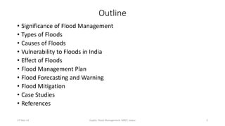
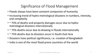
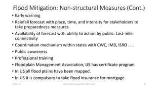
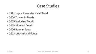
The document discusses flood management in India. It outlines the significance of flood management, describing various types of floods and their causes. It notes that India is highly vulnerable to floods, which can have devastating effects. The document then covers India's flood management plan, including forecasting, mitigation efforts, and case studies. Structural measures like dams and non-structural measures like insurance and education are discussed.
this presentation gives a brief about what are the different types of floods depending upon area & its cause.It is further aided with mitigation or management techniques to be implemented & types of damages.
Floods have the greatest damage potential when compared to the other natural disasters, over the environment. Floods are also considered to be both social and economic disasters. This module highlights the details of floods as natural hazards.
Irrigation system of Pakistan proved at top level of countries in the world but still it need deep concern regarding to control flood water. Due to heavy rainfall in September 2011, floods are come in left bank of drain and it has many impacts on the various cities and villages of sindh were observed, at least 360 people were killed, some 5.35 Million people and 1.2 Million homes affected as well 1.7 Million Acres of arable land inundated. Social life was fully disturbed as economy was destroyed due to damage of crop, people were also suffering from drinking water which was not purely provided and due to this dirty water many of the diseases were appeared like direa, malaria and tified. In this research we measure the losses during heavy rain fall 2011 in Nawabshah, Sh Benazeerabad regarding to impact on our social lives and then its precautions in future planning. Data was collected from social survey in premises of city, different departments including NGO’s and Governmental Departments and also solutions on immediate basis are discussed.
Disaster Management Flooding and Landslidesonika patel
Management of disaster on the basis of Guidelines framework, of landslide & Flooding with the respective case study and flood forecasting and management
Presentation contains Detailed Introduction, types, classification, features, prevention & precaution, causes, effects, indications and Two case studies of Indian context.
Tools and Technologies for Water Resources Planning and Climate Change Adapta...Vitor Vieira Vasconcelos
Objectives:
- To achieve basic understanding on steps in water resources planning
- To have better understanding on tool/technology that can be used for water resource planning and climate change adaptation
- To jointly assess the impacts of climate changes on water resources in Nepal
- To brainstorm the options to address the identified issues for planning processes
Contents:
Section 1 : Introduction to Integrated Water Resources Management (IWRM) and decision support tools
Section 2 : Tools and Techniques for IWRM
Section 3 : Group works
Presented by Giriraj Amarnath at the National Workshop on “Use of Space Based Information for Disaster Management” Colombo, Sri Lanka, November 17, 2014
The presentation is prepared to study the 2013 Kedarnath incident, starting with basic introduction to disaster, Kedarnath and related incidents that followed one after another. It includes mapping, identifying shortcomings, provide recommendations and analyse the statistics of death and injured persons. Also involves study of the relief forces and organizations involved in the rescue operations. Finally concluded with inferences and suggestions from the study.
Floods can be hugely destructive, but they also offer opportunities for farmers and fisherfolk. If their frequency and extent can be measured, then we will be better able to mitigate costs and maximise benefits. Digital geospatial flood inundation mapping is a powerful new approach for flood response that shows floodwater extent and depth on the land surface. IWMI research will evaluate this new technology and develop a prototype flood inundation map for South Asia. Also discussed is a project to flood map and model in a spate irrigation system in Sudan.
Evaluation of Non-structural and Structural Flood Management MeasuresAM Publications
The flooding can have ruinous impacts on the society and the environment. The cities are mostly located
on the banks of rivers, coasts or in the valleys.Urbanisation leads to developed catchments which are densly populated
and are centres of economic activities with vital infrasturcture. The loss of assets is directly related with flood
exposure.The thorough knowledge of flood exposure helps in developing effctive flood management measures. In the
present study flood exposure analyses is performed by using GIS tool. The landuse and flood map data is integrated in
GIS framework to develope flood exposure map. Flood exposure map can be used to compute the flood losses at
different locations in the watershed.The existing non-structrual flood management measures are evaluated using the
flood losses.To protect the lives and properties, structural flood management measure is proposed and evaluated.The
proposed methodology is developed for Upper Godavari basin of Nashik city in Maharashtra of India
1. Flood Management
Dr. Kailash Gupta
M. Tech. (Disaster Assessment & Mitigation) class, November 12, 2013
Malaviya National Institute of Technology, Jaipur
27-Sep-14 Gupta, Flood Management, MNIT, Jaipur 1
2. Outline
• Significance of Flood Management
• Types of Floods
• Causes of Floods
• Vulnerability to Floods in India
• Effect of Floods
• Flood Management Plan
• Flood Forecasting and Warning
• Flood Mitigation
• Case Studies
• References
27-Sep-14 Gupta, Flood Management, MNIT, Jaipur 2
3. Significance of Flood Management
• Floods always have been constant companion of humanity
• Increasing trend of hydro-metrological disasters in numbers, intensity,
and complexity
• ~ 75% of deaths and property damages occur due to hydro-metrological
disasters internationally
• ~ 75% deaths occur due to drawing in floods internationally
• ~ 75% deaths due to disasters occur in South-East Asia
• Disasters have political significance, i.e. creation of Bangladesh
• India is one of the most flood prone countries of the world
27-Sep-14 Gupta, Flood Management, MNIT, Jaipur 3
4. Significance of Flood Management (Cont.)
• In India on an average 1,588 people died, 3 cr. affected, 12 lakh
houses damaged, and Rs. 1805 cr. loss per year during 1953 to 2005
• Article 21 of the constitution, “No person shall be deprived of his life .
. .”
27-Sep-14 Gupta, Flood Management, MNIT, Jaipur 4
5. Flood
• A flood is an overflow of water that submerges land which is normally
dry
• Periodic floods occur on many rivers, forming a surrounding region
known as the flood plain.
27-Sep-14 Gupta, Flood Management, MNIT, Jaipur 5
6. Types of Floods
Areal (rainfall related)
• Floods can happen on flat or low-lying areas when the ground is
saturated and water either cannot run off or cannot run off quickly
enough to stop accumulating.
• Floods can also occur if water falls on an impermeable surface, such
as concrete, paving or frozen ground, and cannot rapidly dissipate
into the ground.
Riverine
• The increase in flow may be the result of sustained rainfall, rapid
snow melt, monsoons, or tropical cyclones.
• Localized flooding may be caused or exacerbated by drainage
obstructions such as landslides, ice, or debris.
27-Sep-14 Gupta, Flood Management, MNIT, Jaipur 6
7. Types of Floods (Cont.)
Flash floods
Occur due to intense thunderstorms or sudden release from an
upstream impoundment created behind a dam, landslide, or glacier.
Snow-melt floods
Monsoon floods
Cyclone floods
Floods due to dam burst/ failure
Urban floods
27-Sep-14 Gupta, Flood Management, MNIT, Jaipur 7
8. Causes of Floods
• Heavy rainfall
• Inadequate capacity of rivers to carry the high flood discharge
• Inadequate drainage to carry away the rainwater quickly to stream /
rivers
• Ice jams or landslides blocking streams
• Cyclones
• Poor permeability of the soil
• Dam (including gate opening), levees, retention ponds, or any water
retaining structure breakage
• High accelerated snow melting
27-Sep-14 Gupta, Flood Management, MNIT, Jaipur 8
9. Causes of Floods (Cont.)
• Highly silted river system
• Steep and highly erodible mountains
• Monsoon concentration in June – Sept.
• Unusual high tides
• Tsunamis
• Exceeding of water flow rate compared to the capacity of the river
channel, particularly at bends or meanders in the waterway
27-Sep-14 Gupta, Flood Management, MNIT, Jaipur 9
10. Vulnerability to Floods in India
• 23 out of 35 states and union territories are vulnerable to floods
• Major flood prone states are Assam, Bihar, West Bengal, UP, and
Orissa
• Major flood prone basins are Ganga, Brahmaputra, and Mahanadi
• 40 m hectares, constituting 12% of land in India is vulnerable to
floods and river erosion
• Women and children are more vulnerable to floods
• Most deaths occur due to drowning
• (Govt. of India, 2012)
27-Sep-14 Gupta, Flood Management, MNIT, Jaipur 10
11. Effects of Floods
Primary Effects
• Loss of life
• Infrastructure damage, including buildings, bridges,
sewerage systems, transport, and electricity facilities, that affect
relief, communication, and drinking water
• Agriculture
• Water born diseases
Secondary and Long-term Effects
• Post-traumatic stress disorder
• Livelihood
27-Sep-14 Gupta, Flood Management, MNIT, Jaipur 11
12. Flood Management Plan
• Flood management means methods to reduce or prevent the detrimental
effects of flood
• National Flood Control Program started in 1954
• Flood Management Program of Ministry of Water Resources, GOI is to
assist states for river management, flood control, anti-erosion, drainage
development, flood proofing, restoration of damaged flood management
works, and anti-sea erosion
• XI Plan (2007-12) had 406 schemes in 19 states with outlay of Rs. 8,000 crs.
and 80% funding by GOI. Rs. 7,575 invested
• Recommendation for XII Plan, Rs 16,000 crs.
• Central Water Commission is the nodal agency
• Indian Metrological Department
• ISRO - sensors platform, provide satellite data, monitors real-time impact
of extreme weather, R&D for improvement. Flood inundation mapping to
MHA and states. In 2013, 109 maps were created
27-Sep-14 Gupta, Flood Management, MNIT, Jaipur 12
13. Flood Management Plan (Cont.)
• Annual Conference of Relief Commissioners/ Secretaries of Disaster
Management of States/ UTs to Review States of Preparedness for
South-West Monsoon. This is year it was on May 14, 2013, in Vigyan
Bhawan, New Delhi
• In Rajasthan, CM chairs a (Video) conference with Secretaries of
relevant departments and Collectors
• In Rajasthan districts, Flood Control Cells are created during monsoon
• In Jaipur, Flood Control Cells were created at Banipark, Ghat Gate, and
Mansorver with sandbags, labor, mud pumps (12), earth-moving
equipment. Officers were posted round the clock
27-Sep-14 Gupta, Flood Management, MNIT, Jaipur 13
14. Flood Forecasting and Warning
• Indian Metrological Department forecasts rains
• District level forecasts on the webpage for all 604 districts, including
thunder storm warning
• Every Friday 2 week qualitative outlook
• 215 cities forecast for 7 days
• Weather warning 3 days in advance
• 15 Doppler weather radars are used, one of them at Jaipur
• 10 Flood Metrological Offices
27-Sep-14 Gupta, Flood Management, MNIT, Jaipur 14
15. Flood Forecasting and Warning (Cont.)
• CWC started flood forecasting in 1958
• About 6,000 flood forecasts issued during monsoon every year
• 166 Flood Forecasting Centers of CWC (134 level forecasting & 32
inflow forecasting)
• Flood forecast and warning dissemination on http://india-water.
gov.in, apart from special messengers, telephone, Fax, wireless,
emails, SMS, and media
• IMD claims rain forecast is 95% accurate
• CWC claim flood forecasting is 98% accurate (forecast water level is within 15 cm of
actual water level of the inflow forecast and is within 20% of actual discharge)
• Then why 1,588 people die every year due to floods?
27-Sep-14 Gupta, Flood Management, MNIT, Jaipur 15
16. Flood Mitigation
• National Flood Risk Mitigation Project – “This project aims to mitigate
consequences of floods by improving capacity for effective
preparedness, promptness in response and to assess the risk and
vulnerabilities associated with floods” (Government of India, 2011. p. 25). NDMA
to prepare DPR
27-Sep-14 Gupta, Flood Management, MNIT, Jaipur 16
17. Flood Mitigation: Structural Measures
Short Term
• Inspection and maintenance of structures, embankments, and flood
walls
• Channel improvement
• Drainage clearance
• Diversion of flood water
27-Sep-14 Gupta, Flood Management, MNIT, Jaipur 17
18. Flood Mitigation: Structural Measures (cont.)
Long Term
• Adequate no. of raised platforms and shelters with amentias
• Dams and reservoirs
• Embankments, flood walls, sea walls
• Natural detention basins
• Channel improvement
• Drainage improvement
• Diversion of flood water
• Flood-safe public utility installations
27-Sep-14 Gupta, Flood Management, MNIT, Jaipur 18
19. Flood Mitigation: Non-structural Measures
Short Term
• Insurance cover
• Public awareness about health problems and illness
Long Term
• National Flood Atlas has been prepared by the CWC
• Flood forecasting model of the Godavri Basin prepared and real-time
simulation is done
• Flood plain zoning
• Removal of human encroachments from flood plains
• Depopulating the flood plains
• Afforestation
27-Sep-14 Gupta, Flood Management, MNIT, Jaipur 19
20. Flood Mitigation: Non-structural Measures (Cont.)
• Early warning
• Rainfall forecast with place, time, and intensity for stakeholders to
take preparedness measures
• Availability of forecast with ability to action by public. Last-mile
connectivity
• Coordination mechanism within states with CWC, IMD, ISRO . . .
• Public awareness
• Professional training
• Floodplain Management Association, US has certificate program
• In US all flood plains have been mapped.
• In US it is compulsory to take flood insurance for mortgage
27-Sep-14 Gupta, Flood Management, MNIT, Jaipur 20
22. References
• Central Water Commission. (May 2013). Flood forecasting and warning mechanism. Presentation at the Annual
Conference of Relief Commissioners/ Secretaries of Disaster Management of States/ UTs to Review States
of Preparedness for South-West Monsoon. New Delhi: Government of India, Ministry of Home Affairs
• Govt. of India, Ministry of Home Affairs. (2008). National disaster management guidelines: Management of floods.
New Delhi: Author
• Govt. of India, Ministry of Home Affairs. (2011). State level programmes for strengthening disaster management in
India: Initiatives by Ministry of Home Affairs, GoI. New Delhi: Author
• Govt. of India, Ministry of Home Affairs. (2012). Disaster management in India. New Delhi: Author
• Gupta, A. K. (June 2013). Floods: causes, consequences and management. Presentation at the State Level
Workshop on Flood Management. Jaipur: HCM Rajasthan State Institute of Public Administration
• Indira Gandhi National Open University. (2005). Understanding natural disasters. MPA-001. New Delhi:
Author
• Kaushik, A. D. (2012). Flood risk mitigation and management: A training of trainers (TOT) module. New
Delhi: National Institute of Disaster Management
• Yadav, B. P. (May 2013). Forecasting of Southwest monsoon 2013, cyclone warning services and IMD’s future
plans for enhancement of its forecasting capabilities. Presentation at the Annual Conference of Relief
Commissioners/ Secretaries of Disaster Management of States/ UTs to Review States of
Preparedness for South-West Monsoon. New Delhi: Government of India, Ministry of Home Affairs
27-Sep-14 Gupta, Flood Management, MNIT, Jaipur 22