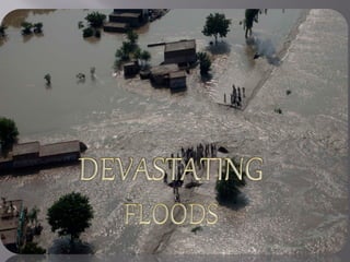
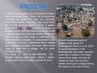
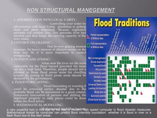
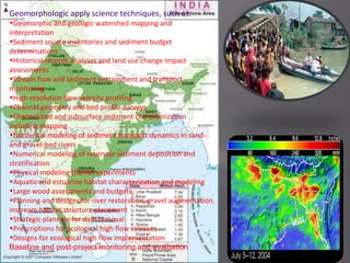
SlideShare a Scribd company logo
A flood is an overflow of an expanse of water
that submerges land. Flood as a temporary
covering by water of land not normally
covered by water. Flooding may result from
the volume of water within a body of water,
such as a river or lake, which overflows or
breaks levees, with the result that some of the
water escapes its usual boundaries. While the
size of a lake or other body of water will vary
with seasonal changes in precipitation and
snow melt, it is not a significant flood unless
such escapes of water endanger land areas
used by man like a village, city or other
inhabited area.
The flood of 1931 in the HWANG HO ,
flooded China’s great plain , killing 2 million
people that’s why it’s called sorrow of china.
Floods devastated parts of
eastern India along the
Brahmaputra River in June 2000.
In some tributaries of the
Brahmaputra, the water reached
more than 5 meters (16.5 feet)
above flood stage. At least 40
residents died, and the flood
waters destroyed a bridge linking
the region to the rest of India.
TYPES OF FLOOD:TYPES OF FLOOD:
1. RIVER FLOOD: Caused by
excess water flow in the river
channel.
2. RESERVOIR FLOOD: Caused by
failures of natural or man made
dams.
3. COASTAL FLOOD: Caused by
severe storms or as a result of
another hazards e.g. TSUNAMI
or HURRICANE.
4. FLASH FLOOD: Dangerously
fast moving floods caused by a
large amount of heavy rainfall in
localized area.
CAUSES OF FLOODSCAUSES OF FLOODS
:
(1)HIGH RAINFALL: Heavy rainfall rises the water
level, when the water level is higher than the river
bank or the dams, the water comes out from the
river there will be flooding.
(2)SNOW MELT :Because of high temperature the
ice caps melt and the water rises of the sea level
and makes the river level rise and then flooding
may occur.
(3)LOW RELIEF: Flooding often occurs in
lowlands. This is because rivers flow more slowly
in low lying areas. If the water volume increases
suddenly, floods occur.
(4)HIGH TIDES & STROMS: Flooding always
occurs in coastal areas. High tides or storms cause
the water level to rise. If the water level is higher
than the level of coastal lowland flooding will occur.
(5)UPLIFTMENT OF RIVER BASIN: When river bed upliftment happened along the fault line,
the river water flow out in submerges land and flood takes place.
(6)RIVER CAPACITY REDUCED BY SILTATION: At the mouth of river sedimentation is very high.
Through this mass volume of sedimentation river bed filled up and the water capacity yet reduce,
this creates flooding .
(A) NATURAL
CAUSES OF FLOODS
(B) HUMAN CAUSES OF FLOOD:(B) HUMAN CAUSES OF FLOOD:
(1)DEFORESTATION: Large areas of forests near the rivers
have been cleared. The lands are used to make settlements,
roads and farmland. Less vegetation protects the soil is
quickly lost to rivers and the sea. This rises the river bed. So,
the river overflow in its bank easily.
(2)POOR FARMING:
(a) OVERGRAZING: People want more food and money.
They graze too many animals on the land and the pasture in
eaten away quickly less vegetation cover results in soil
washed into the river easily.
(b) OVER CULTIVATION: When a piece of land has been
used for farming for a long period of time, the soil may
become more infertile that no vegetation cover can grow it.
So, the soil become loose and washed away.
(3)POOR WATER MANAGEMENT: When the dams are
poorly constructed or maintained, they can easily collapse and
this results in flooding.
( 4)POPULATION PRESSURE: Because of large amount of
people, urbanization increase day by day. Construction of
concrete and stone building reduce infiltration and increase
runoff that create a large amount of flood.
(5)DAM COLLAPS: Rain water and excess runoff had almost filled capacity of the reservoir and
siltation decreases the water capacity of the dam the combination of these flaws allowed water to
seep through the dam and led to internal erosion, called piping, that eventually caused the dam's
collapse.
1.Widened river channel :
Along the river course large scale erosion of
the valley bottom resulted from a combination
of concave bank erosion, channel avulsions
(change in channel position within the valley
bottom), and the reactivation/creation of
channels. This may produced a broad flood
channels, which may be a few hundred meters
wide that, in places may be many times wider
than the pre-flood channel. The post-flood
channel also exhibited a multi-channel or
braided planform in contrast to the
predominantly single-channelled meander
landform of the pre-flood river.
2. Deep channel erosion:
Steeper reaches of river may be
eroded by the flood waters. Channel
incision and widening may occur
along a narrow section of valley
bottom. The post-flood channel
perimeter is formed by a boundary
lag, as well as sediments and
bedrock which previously were
buried by river alluvium.
3. Breach in wall of a dam:
There may be breaches in the
dams during sever floods. A breach
in the concrete wing of the dam
may lower the reservoir by several
meters.
4.Valley bottom buried with sediment:
During the flood down stream along a river
extensive aggradations may takes place along
relatively gently sloped reaches of valley. This
possibility takes place in lower reaches of
valley with extensive erosion of upstream.
5. NEW CHANNEL FORMATION BESIDE A
DAM
A new channel may be formed beside a dam by
flooding completely by passing the sluice grates
or barrage. The dam may be left intact, but non-
functional. Such damage may occur when flood
water spill over tap of and erode unconsolidated
deposits of silt, clay etc. along side a dam.
When a river floods over its banks, the water
spreads out , then slows down, and deposits
its load of sediment. Over time, the river's
banks are built up above the level of
the rest of the floodplain. The resulting
ridges are called natural levees.
A floodplain is the relatively flat area that
borders a stream which is periodically
flooded with water during flood periods.
When excess runoff causes the stream
discharge to increase beyond the
capacity of the channel, water spills out
and sediment deposit on the plain land.
7. FORMATION OF FLOOD PLAIN:
8. Landslide caused by flood
Flood is also the cause of many
natural hazards landslide is one
of them, heavy flooding erodes
the soil and geological structure
loses it’s stability. The worst
recent landslide disaster
occurred in Italy’s voiont
reservoir which drowned 2000
people in flood wave.
9. Oxbow Lake formation
When a river reaches a low-lying plain,
Continuous deposition on the convex bank and
erosion of the concave bank of a meandering river
cause the formation of a very pronounced
meander with two concave banks getting closer.
The narrow neck of land between the two
neighboring concave banks is finally cut through
by the strong currents of a flood. When this
happens, a new river channel is created. When
deposition finally seals off the cut-off from the river
channel, an oxbow lake is formed.
Concave bank
erosion at the foot of
a bridge may lead to
collapse of the bridge
and transport
facilities might come
to a halt .
 STRUCTURAL MANAGEMENT:
1. CONFING RIVER FLOW BY EMBANKMENTS :Embankments have been
the principal methods of controlling flood as a short term measure.
Embankments have following advantages –
a) They are easy to construct
parallel to river banks. As shown in
fig1
b) They prevent over flowing banks.
c) Initial cost of construction is less.
d) It increases the storage capacity
of river as shown in fig- 2
But unless the height of the
embankment and maintenance are
not proper, then it may create flood
disaster.
It is the most effective measures of flood
disaster mitigation measure. The modern
reservoir is to store excess water during flood
period and release it when flood subsides.
The figure shows the hydrographs of flood
without and with reservoir.
3. CHANNEL IMPROVEMENT WORKS
Work performed to increase the discharge or
velocity of stream or to decrease the
stage and duration of flood is called
channel improvement works.
It includes :
(a) Widening and depending of the stream.
(b) Straightening the meandering type river by
cut off to reduce travel time of flood.
(c) Smoothing the river bed and sides and
remove roughness offered by sand bed,
weed growth etc.
 It includes the diversion works from
place where flood disasters are likely to
occur. A diversion channel with
regulator upstream of the important
area is constructed (fig), the important
area is placed on convex sides of the
river where inundation and erosion are
possible. The diversion channel
decreases the stage of flood near the
important area and there by possible
flood disaster may be reduced.
5. FLOOD WALL
Flood wall is constructed as local flood
hazard prevention for some important
area situated at low ground level. The
walls are almost parallel to the river.
 1. AFFORESTATION WITH LOCAL VARITY :
Controlling river water by
afforestation with local Varity plantation in getting
more and more important. Because vegetation
prevents soil erosion also. This prevents river bed
siltation and thus keeps the carrying capacity of the
river intact.
2. CONTROL ON GRAZING :
Due to over grazing erosion
increases. So heavy amount of siltation occurs on the
river bed. So it is more important to control
overgrazing.
3. FLOOD PLANE ZONING :
Areas near the river are the most
vulnerable for the flood hazard provided the areas
are not a high land. Therefore, people should not e
allowed to those flood prone areas for dwelling
houses. So zoning of flood prone areas should be
declared by the government..
4. FLOOD FORECASTING :
Flood forecasting or warning if
could be conveyed earlier, disaster due to the
probable flood can be minimized to a great extend.
Temporary evecuation of persons and shifting the
important property to safer places could be done
before the flood arives.
5. MATHEMATICAL MODELLING :
Mathematical model has becomea very powerful tool in this age by the use of modern high speed computer in flood disaster measures.
Mathematical model by computer can predict flood intensity inundation whether it is flood in river or a
flash flood due to the dam break.
Geomorphologic apply science techniques, such as:
•Geomorphic and geologic watershed mapping and
interpretation
•Sediment source inventories and sediment budget
determinations
•Historical records analyses and land use change impact
assessments
•Stream flow and sediment entrainment and transport
monitoring
•High-resolution flow velocity profiling
•Channel geometry and bed profile surveys
•Channel bed and subsurface sediment characterization
including mapping
•Numerical modeling of sediment transport dynamics in sand-
and gravel-bed rivers
•Numerical modeling of reservoir sediment deposition and
stratification
•Physical modeling (flume) experiments
•Aquatic and estuarine habitat characterization and modeling
•Large wood assessments and budgets,
•Planning and designs for river restoration, gravel augmentation,
instream habitat structure placement
•Strategic planning for dam removal
•Prescriptions for ecological high flow releases
•Designs for ecological high flow implementation
Baseline and post-project monitoring and evaluation
Thank You
This presentation is presented by –
Arijita Deb.
M.Sc in Geography

More Related Content

What's hot

Flood
FloodFlood
Flood ppt
Flood pptFlood ppt
Flood ppt
Pragati Singham
 
floods
floodsfloods
Floods in India
Floods in IndiaFloods in India
Floods in India
Nitika Nikks
 
Floods. disaster management
Floods. disaster managementFloods. disaster management
Floods. disaster management
Chetankumar Banakar
 
Flood presentation with more media
Flood presentation with more mediaFlood presentation with more media
Flood presentation with more media
Gaurav Devnath
 
Landslides
Landslides Landslides
Landslides
Akhila S
 
Disaster management for floods
Disaster management for floodsDisaster management for floods
Disaster management for floods
Manu Kuldeep
 
Disaster management of floods..
Disaster management of floods..Disaster management of floods..
Disaster management of floods..
Surabhi Vasudev
 
Civil flood ppt
Civil flood pptCivil flood ppt
Civil flood ppt
rajababu9123
 
Flood management
Flood managementFlood management
Flood management
Bhavik A Shah
 
Cyclone disaster management
Cyclone disaster managementCyclone disaster management
Cyclone disaster management
Dr. Fayaz Ahmad Malla
 
Flood management in Pakistan ppt
Flood management in Pakistan pptFlood management in Pakistan ppt
Flood management in Pakistan ppt
Pari Doll
 
Floods
Floods Floods
Impacts Of Floods
Impacts Of FloodsImpacts Of Floods
Impacts Of Floods
James Foster
 
Flooding – a natural disaster
Flooding – a natural disasterFlooding – a natural disaster
Flooding – a natural disaster
Thato Kutu
 
Landslides with case studies Presentation by Anand Swaroop Jaichandran
Landslides with case studies Presentation by Anand Swaroop JaichandranLandslides with case studies Presentation by Anand Swaroop Jaichandran
Landslides with case studies Presentation by Anand Swaroop Jaichandran
Anand Swaroop Jaichandran
 

What's hot (20)

Flood
FloodFlood
Flood
 
Flood ppt
Flood pptFlood ppt
Flood ppt
 
floods
floodsfloods
floods
 
Floods in India
Floods in IndiaFloods in India
Floods in India
 
Floods. disaster management
Floods. disaster managementFloods. disaster management
Floods. disaster management
 
floods
floodsfloods
floods
 
Flood presentation with more media
Flood presentation with more mediaFlood presentation with more media
Flood presentation with more media
 
Landslides
Landslides Landslides
Landslides
 
Disaster management for floods
Disaster management for floodsDisaster management for floods
Disaster management for floods
 
Disaster management of floods..
Disaster management of floods..Disaster management of floods..
Disaster management of floods..
 
Civil flood ppt
Civil flood pptCivil flood ppt
Civil flood ppt
 
Flood management
Flood managementFlood management
Flood management
 
Cyclone disaster management
Cyclone disaster managementCyclone disaster management
Cyclone disaster management
 
Flood management in Pakistan ppt
Flood management in Pakistan pptFlood management in Pakistan ppt
Flood management in Pakistan ppt
 
Floods
Floods Floods
Floods
 
Impacts Of Floods
Impacts Of FloodsImpacts Of Floods
Impacts Of Floods
 
Drought
DroughtDrought
Drought
 
Avalanche
AvalancheAvalanche
Avalanche
 
Flooding – a natural disaster
Flooding – a natural disasterFlooding – a natural disaster
Flooding – a natural disaster
 
Landslides with case studies Presentation by Anand Swaroop Jaichandran
Landslides with case studies Presentation by Anand Swaroop JaichandranLandslides with case studies Presentation by Anand Swaroop Jaichandran
Landslides with case studies Presentation by Anand Swaroop Jaichandran
 

Viewers also liked

Narrative and Performance
Narrative and PerformanceNarrative and Performance
Narrative and Performance
joshrcoulson
 
Actibiti 1 allegra guzman
Actibiti 1 allegra guzmanActibiti 1 allegra guzman
Actibiti 1 allegra guzmana17825
 
Assign 33 ancillary rough drafts
Assign 33   ancillary rough draftsAssign 33   ancillary rough drafts
Assign 33 ancillary rough draftsMissConnell
 
Corey Taylor Portfolio
Corey Taylor PortfolioCorey Taylor Portfolio
Corey Taylor PortfolioCorey Taylor
 
Instrução dfjndjncs
Instrução dfjndjncsInstrução dfjndjncs
Instrução dfjndjncs
TASSIO DOURADO
 
In card visit gia re tphcm
In card visit gia re tphcmIn card visit gia re tphcm
In card visit gia re tphcm
In Tinh Tế Printing
 
Sperry Van Ness #CRE Monday National Sales Meeting 11-19-12
Sperry Van Ness #CRE Monday National Sales Meeting 11-19-12Sperry Van Ness #CRE Monday National Sales Meeting 11-19-12
Sperry Van Ness #CRE Monday National Sales Meeting 11-19-12
SVN International Corp.
 
Azhar Abbas QMS LA 9001&2008
Azhar Abbas QMS LA 9001&2008Azhar Abbas QMS LA 9001&2008
Azhar Abbas QMS LA 9001&2008azhar abbas
 
Jeopardy
JeopardyJeopardy
Jeopardy
yadanmc
 
IRPF 2012 Armando Esteve
IRPF 2012 Armando EsteveIRPF 2012 Armando Esteve
IRPF 2012 Armando EsteveUPyDNovelda
 
Vohra case
 Vohra case Vohra case
Vohra case
Abhishek Maloo
 
Población E.U
Población E.UPoblación E.U
Población E.U
geoivc
 
3.pl simpleks
3.pl simpleks3.pl simpleks
3.pl simpleks
wilardo123
 
Herramientas colaborativas mas usadas en la educación
Herramientas colaborativas mas usadas en la educaciónHerramientas colaborativas mas usadas en la educación
Herramientas colaborativas mas usadas en la educación
Saida Patricia Calderón Corzo
 
My brother the devil
My brother the devilMy brother the devil
My brother the devilMissConnell
 
TomGarrecht Short Cuts
TomGarrecht Short CutsTomGarrecht Short Cuts
TomGarrecht Short Cuts
tom garrecht
 

Viewers also liked (17)

Narrative and Performance
Narrative and PerformanceNarrative and Performance
Narrative and Performance
 
Actibiti 1 allegra guzman
Actibiti 1 allegra guzmanActibiti 1 allegra guzman
Actibiti 1 allegra guzman
 
Assign 33 ancillary rough drafts
Assign 33   ancillary rough draftsAssign 33   ancillary rough drafts
Assign 33 ancillary rough drafts
 
Corey Taylor Portfolio
Corey Taylor PortfolioCorey Taylor Portfolio
Corey Taylor Portfolio
 
DIPLOMA
DIPLOMADIPLOMA
DIPLOMA
 
Instrução dfjndjncs
Instrução dfjndjncsInstrução dfjndjncs
Instrução dfjndjncs
 
In card visit gia re tphcm
In card visit gia re tphcmIn card visit gia re tphcm
In card visit gia re tphcm
 
Sperry Van Ness #CRE Monday National Sales Meeting 11-19-12
Sperry Van Ness #CRE Monday National Sales Meeting 11-19-12Sperry Van Ness #CRE Monday National Sales Meeting 11-19-12
Sperry Van Ness #CRE Monday National Sales Meeting 11-19-12
 
Azhar Abbas QMS LA 9001&2008
Azhar Abbas QMS LA 9001&2008Azhar Abbas QMS LA 9001&2008
Azhar Abbas QMS LA 9001&2008
 
Jeopardy
JeopardyJeopardy
Jeopardy
 
IRPF 2012 Armando Esteve
IRPF 2012 Armando EsteveIRPF 2012 Armando Esteve
IRPF 2012 Armando Esteve
 
Vohra case
 Vohra case Vohra case
Vohra case
 
Población E.U
Población E.UPoblación E.U
Población E.U
 
3.pl simpleks
3.pl simpleks3.pl simpleks
3.pl simpleks
 
Herramientas colaborativas mas usadas en la educación
Herramientas colaborativas mas usadas en la educaciónHerramientas colaborativas mas usadas en la educación
Herramientas colaborativas mas usadas en la educación
 
My brother the devil
My brother the devilMy brother the devil
My brother the devil
 
TomGarrecht Short Cuts
TomGarrecht Short CutsTomGarrecht Short Cuts
TomGarrecht Short Cuts
 

Similar to Flood

Rivers, floods and management
Rivers, floods and management Rivers, floods and management
Rivers, floods and management
jamierjhill
 
Paper 1 revision 29.5.13 bv
Paper 1 revision 29.5.13 bvPaper 1 revision 29.5.13 bv
Paper 1 revision 29.5.13 bv
tudorgeog
 
CH-1 Introduction to River Hydraulics.pdf
CH-1 Introduction to River Hydraulics.pdfCH-1 Introduction to River Hydraulics.pdf
CH-1 Introduction to River Hydraulics.pdf
DanielSolomon58
 
Revision booklet 2015 OCR B Geography
Revision booklet 2015 OCR B GeographyRevision booklet 2015 OCR B Geography
Revision booklet 2015 OCR B Geography
Mrs Coles
 
introduction.ppt
introduction.pptintroduction.ppt
introduction.ppt
ManamnoBeza1
 
Rivers - George Mather, Chris Hancox, Alex Owen and Michael Soley
Rivers - George Mather, Chris Hancox, Alex Owen and Michael SoleyRivers - George Mather, Chris Hancox, Alex Owen and Michael Soley
Rivers - George Mather, Chris Hancox, Alex Owen and Michael SoleyKeith Phipps
 
SDME revision pack 2016
SDME revision pack 2016SDME revision pack 2016
SDME revision pack 2016
Mrs Coles
 
L4 Levees And Floodplains
L4 Levees And FloodplainsL4 Levees And Floodplains
L4 Levees And Floodplainstudorgeog
 
River Development.ppt
River Development.pptRiver Development.ppt
River Development.ppt
ManamnoBeza1
 
Geological action of river
Geological action of riverGeological action of river
Geological action of river
Rizwan Siddique
 
13.4 Stages of a River.ppt
13.4 Stages of a River.ppt13.4 Stages of a River.ppt
13.4 Stages of a River.ppt
GAMINGBUZZ5
 
floodplain presentation
floodplain presentationfloodplain presentation
floodplain presentation
rupankar456
 
River Channel Processes & Landforms
River Channel Processes & LandformsRiver Channel Processes & Landforms
River Channel Processes & LandformsMalia Damit
 
Diversion headworks
Diversion headworksDiversion headworks
Diversion headworks
Jimit Shah
 
Sec 3 Rivers
Sec 3 RiversSec 3 Rivers
Sec 3 Rivers
Ron Tan
 
CAMBRIDGE GEOGRAPHY AS - HYDROLOGY AND FLUVIAL GEOMORPHOLOGY: 1.3 RIVER CHANN...
CAMBRIDGE GEOGRAPHY AS - HYDROLOGY AND FLUVIAL GEOMORPHOLOGY: 1.3 RIVER CHANN...CAMBRIDGE GEOGRAPHY AS - HYDROLOGY AND FLUVIAL GEOMORPHOLOGY: 1.3 RIVER CHANN...
CAMBRIDGE GEOGRAPHY AS - HYDROLOGY AND FLUVIAL GEOMORPHOLOGY: 1.3 RIVER CHANN...
George Dumitrache
 
River Processes & Landscapes
River Processes & LandscapesRiver Processes & Landscapes
River Processes & Landscapes
Mohammad Hassan Ally
 
UNIT. 4. Rivers.pptx, river system, tribuary
UNIT. 4. Rivers.pptx, river system, tribuaryUNIT. 4. Rivers.pptx, river system, tribuary
UNIT. 4. Rivers.pptx, river system, tribuary
AbdinasirAhmedMohame2
 

Similar to Flood (20)

Rivers, floods and management
Rivers, floods and management Rivers, floods and management
Rivers, floods and management
 
Paper 1 revision 29.5.13 bv
Paper 1 revision 29.5.13 bvPaper 1 revision 29.5.13 bv
Paper 1 revision 29.5.13 bv
 
CH-1 Introduction to River Hydraulics.pdf
CH-1 Introduction to River Hydraulics.pdfCH-1 Introduction to River Hydraulics.pdf
CH-1 Introduction to River Hydraulics.pdf
 
Revision booklet 2015 OCR B Geography
Revision booklet 2015 OCR B GeographyRevision booklet 2015 OCR B Geography
Revision booklet 2015 OCR B Geography
 
introduction.ppt
introduction.pptintroduction.ppt
introduction.ppt
 
Rivers - George Mather, Chris Hancox, Alex Owen and Michael Soley
Rivers - George Mather, Chris Hancox, Alex Owen and Michael SoleyRivers - George Mather, Chris Hancox, Alex Owen and Michael Soley
Rivers - George Mather, Chris Hancox, Alex Owen and Michael Soley
 
SDME revision pack 2016
SDME revision pack 2016SDME revision pack 2016
SDME revision pack 2016
 
L4 Levees And Floodplains
L4 Levees And FloodplainsL4 Levees And Floodplains
L4 Levees And Floodplains
 
River Development.ppt
River Development.pptRiver Development.ppt
River Development.ppt
 
Geological action of river
Geological action of riverGeological action of river
Geological action of river
 
13.4 Stages of a River.ppt
13.4 Stages of a River.ppt13.4 Stages of a River.ppt
13.4 Stages of a River.ppt
 
floodplain presentation
floodplain presentationfloodplain presentation
floodplain presentation
 
Rivers Revision
Rivers RevisionRivers Revision
Rivers Revision
 
Module iii notes
Module iii notesModule iii notes
Module iii notes
 
River Channel Processes & Landforms
River Channel Processes & LandformsRiver Channel Processes & Landforms
River Channel Processes & Landforms
 
Diversion headworks
Diversion headworksDiversion headworks
Diversion headworks
 
Sec 3 Rivers
Sec 3 RiversSec 3 Rivers
Sec 3 Rivers
 
CAMBRIDGE GEOGRAPHY AS - HYDROLOGY AND FLUVIAL GEOMORPHOLOGY: 1.3 RIVER CHANN...
CAMBRIDGE GEOGRAPHY AS - HYDROLOGY AND FLUVIAL GEOMORPHOLOGY: 1.3 RIVER CHANN...CAMBRIDGE GEOGRAPHY AS - HYDROLOGY AND FLUVIAL GEOMORPHOLOGY: 1.3 RIVER CHANN...
CAMBRIDGE GEOGRAPHY AS - HYDROLOGY AND FLUVIAL GEOMORPHOLOGY: 1.3 RIVER CHANN...
 
River Processes & Landscapes
River Processes & LandscapesRiver Processes & Landscapes
River Processes & Landscapes
 
UNIT. 4. Rivers.pptx, river system, tribuary
UNIT. 4. Rivers.pptx, river system, tribuaryUNIT. 4. Rivers.pptx, river system, tribuary
UNIT. 4. Rivers.pptx, river system, tribuary
 

Recently uploaded

Natural farming @ Dr. Siddhartha S. Jena.pptx
Natural farming @ Dr. Siddhartha S. Jena.pptxNatural farming @ Dr. Siddhartha S. Jena.pptx
Natural farming @ Dr. Siddhartha S. Jena.pptx
sidjena70
 
Q&A with the Experts: The Food Service Playbook
Q&A with the Experts: The Food Service PlaybookQ&A with the Experts: The Food Service Playbook
Q&A with the Experts: The Food Service Playbook
World Resources Institute (WRI)
 
Sustainable farming practices in India .pptx
Sustainable farming  practices in India .pptxSustainable farming  practices in India .pptx
Sustainable farming practices in India .pptx
chaitaliambole
 
Daan Park Hydrangea flower season I like it
Daan Park Hydrangea flower season I like itDaan Park Hydrangea flower season I like it
Daan Park Hydrangea flower season I like it
a0966109726
 
alhambra case study Islamic gardens part-2.pptx
alhambra case study Islamic gardens part-2.pptxalhambra case study Islamic gardens part-2.pptx
alhambra case study Islamic gardens part-2.pptx
CECOS University Peshawar, Pakistan
 
AGRICULTURE Hydrophonic FERTILISER PPT.pptx
AGRICULTURE Hydrophonic FERTILISER PPT.pptxAGRICULTURE Hydrophonic FERTILISER PPT.pptx
AGRICULTURE Hydrophonic FERTILISER PPT.pptx
BanitaDsouza
 
Artificial Reefs by Kuddle Life Foundation - May 2024
Artificial Reefs by Kuddle Life Foundation - May 2024Artificial Reefs by Kuddle Life Foundation - May 2024
Artificial Reefs by Kuddle Life Foundation - May 2024
punit537210
 
How about Huawei mobile phone-www.cfye-commerce.shop
How about Huawei mobile phone-www.cfye-commerce.shopHow about Huawei mobile phone-www.cfye-commerce.shop
How about Huawei mobile phone-www.cfye-commerce.shop
laozhuseo02
 
growbilliontrees.com-Trees for Granddaughter (1).pdf
growbilliontrees.com-Trees for Granddaughter (1).pdfgrowbilliontrees.com-Trees for Granddaughter (1).pdf
growbilliontrees.com-Trees for Granddaughter (1).pdf
yadavakashagra
 
DRAFT NRW Recreation Strategy - People and Nature thriving together
DRAFT NRW Recreation Strategy - People and Nature thriving togetherDRAFT NRW Recreation Strategy - People and Nature thriving together
DRAFT NRW Recreation Strategy - People and Nature thriving together
Robin Grant
 
一比一原版(UMTC毕业证书)明尼苏达大学双城分校毕业证如何办理
一比一原版(UMTC毕业证书)明尼苏达大学双城分校毕业证如何办理一比一原版(UMTC毕业证书)明尼苏达大学双城分校毕业证如何办理
一比一原版(UMTC毕业证书)明尼苏达大学双城分校毕业证如何办理
zm9ajxup
 
Alert-driven Community-based Forest monitoring: A case of the Peruvian Amazon
Alert-driven Community-based Forest monitoring: A case of the Peruvian AmazonAlert-driven Community-based Forest monitoring: A case of the Peruvian Amazon
Alert-driven Community-based Forest monitoring: A case of the Peruvian Amazon
CIFOR-ICRAF
 
"Understanding the Carbon Cycle: Processes, Human Impacts, and Strategies for...
"Understanding the Carbon Cycle: Processes, Human Impacts, and Strategies for..."Understanding the Carbon Cycle: Processes, Human Impacts, and Strategies for...
"Understanding the Carbon Cycle: Processes, Human Impacts, and Strategies for...
MMariSelvam4
 
International+e-Commerce+Platform-www.cfye-commerce.shop
International+e-Commerce+Platform-www.cfye-commerce.shopInternational+e-Commerce+Platform-www.cfye-commerce.shop
International+e-Commerce+Platform-www.cfye-commerce.shop
laozhuseo02
 
ppt on beauty of the nature by Palak.pptx
ppt on  beauty of the nature by Palak.pptxppt on  beauty of the nature by Palak.pptx
ppt on beauty of the nature by Palak.pptx
RaniJaiswal16
 
Presentación Giulio Quaggiotto-Diálogo improbable .pptx.pdf
Presentación Giulio Quaggiotto-Diálogo improbable .pptx.pdfPresentación Giulio Quaggiotto-Diálogo improbable .pptx.pdf
Presentación Giulio Quaggiotto-Diálogo improbable .pptx.pdf
Innovation and Technology for Development Centre
 
Sustainable Rain water harvesting in india.ppt
Sustainable Rain water harvesting in india.pptSustainable Rain water harvesting in india.ppt
Sustainable Rain water harvesting in india.ppt
chaitaliambole
 
Navigating the complex landscape of AI governance
Navigating the complex landscape of AI governanceNavigating the complex landscape of AI governance
Navigating the complex landscape of AI governance
Piermenotti Mauro
 
Environmental Science Book By Dr. Y.K. Singh
Environmental Science Book By Dr. Y.K. SinghEnvironmental Science Book By Dr. Y.K. Singh
Environmental Science Book By Dr. Y.K. Singh
AhmadKhan917612
 
UNDERSTANDING WHAT GREEN WASHING IS!.pdf
UNDERSTANDING WHAT GREEN WASHING IS!.pdfUNDERSTANDING WHAT GREEN WASHING IS!.pdf
UNDERSTANDING WHAT GREEN WASHING IS!.pdf
JulietMogola
 

Recently uploaded (20)

Natural farming @ Dr. Siddhartha S. Jena.pptx
Natural farming @ Dr. Siddhartha S. Jena.pptxNatural farming @ Dr. Siddhartha S. Jena.pptx
Natural farming @ Dr. Siddhartha S. Jena.pptx
 
Q&A with the Experts: The Food Service Playbook
Q&A with the Experts: The Food Service PlaybookQ&A with the Experts: The Food Service Playbook
Q&A with the Experts: The Food Service Playbook
 
Sustainable farming practices in India .pptx
Sustainable farming  practices in India .pptxSustainable farming  practices in India .pptx
Sustainable farming practices in India .pptx
 
Daan Park Hydrangea flower season I like it
Daan Park Hydrangea flower season I like itDaan Park Hydrangea flower season I like it
Daan Park Hydrangea flower season I like it
 
alhambra case study Islamic gardens part-2.pptx
alhambra case study Islamic gardens part-2.pptxalhambra case study Islamic gardens part-2.pptx
alhambra case study Islamic gardens part-2.pptx
 
AGRICULTURE Hydrophonic FERTILISER PPT.pptx
AGRICULTURE Hydrophonic FERTILISER PPT.pptxAGRICULTURE Hydrophonic FERTILISER PPT.pptx
AGRICULTURE Hydrophonic FERTILISER PPT.pptx
 
Artificial Reefs by Kuddle Life Foundation - May 2024
Artificial Reefs by Kuddle Life Foundation - May 2024Artificial Reefs by Kuddle Life Foundation - May 2024
Artificial Reefs by Kuddle Life Foundation - May 2024
 
How about Huawei mobile phone-www.cfye-commerce.shop
How about Huawei mobile phone-www.cfye-commerce.shopHow about Huawei mobile phone-www.cfye-commerce.shop
How about Huawei mobile phone-www.cfye-commerce.shop
 
growbilliontrees.com-Trees for Granddaughter (1).pdf
growbilliontrees.com-Trees for Granddaughter (1).pdfgrowbilliontrees.com-Trees for Granddaughter (1).pdf
growbilliontrees.com-Trees for Granddaughter (1).pdf
 
DRAFT NRW Recreation Strategy - People and Nature thriving together
DRAFT NRW Recreation Strategy - People and Nature thriving togetherDRAFT NRW Recreation Strategy - People and Nature thriving together
DRAFT NRW Recreation Strategy - People and Nature thriving together
 
一比一原版(UMTC毕业证书)明尼苏达大学双城分校毕业证如何办理
一比一原版(UMTC毕业证书)明尼苏达大学双城分校毕业证如何办理一比一原版(UMTC毕业证书)明尼苏达大学双城分校毕业证如何办理
一比一原版(UMTC毕业证书)明尼苏达大学双城分校毕业证如何办理
 
Alert-driven Community-based Forest monitoring: A case of the Peruvian Amazon
Alert-driven Community-based Forest monitoring: A case of the Peruvian AmazonAlert-driven Community-based Forest monitoring: A case of the Peruvian Amazon
Alert-driven Community-based Forest monitoring: A case of the Peruvian Amazon
 
"Understanding the Carbon Cycle: Processes, Human Impacts, and Strategies for...
"Understanding the Carbon Cycle: Processes, Human Impacts, and Strategies for..."Understanding the Carbon Cycle: Processes, Human Impacts, and Strategies for...
"Understanding the Carbon Cycle: Processes, Human Impacts, and Strategies for...
 
International+e-Commerce+Platform-www.cfye-commerce.shop
International+e-Commerce+Platform-www.cfye-commerce.shopInternational+e-Commerce+Platform-www.cfye-commerce.shop
International+e-Commerce+Platform-www.cfye-commerce.shop
 
ppt on beauty of the nature by Palak.pptx
ppt on  beauty of the nature by Palak.pptxppt on  beauty of the nature by Palak.pptx
ppt on beauty of the nature by Palak.pptx
 
Presentación Giulio Quaggiotto-Diálogo improbable .pptx.pdf
Presentación Giulio Quaggiotto-Diálogo improbable .pptx.pdfPresentación Giulio Quaggiotto-Diálogo improbable .pptx.pdf
Presentación Giulio Quaggiotto-Diálogo improbable .pptx.pdf
 
Sustainable Rain water harvesting in india.ppt
Sustainable Rain water harvesting in india.pptSustainable Rain water harvesting in india.ppt
Sustainable Rain water harvesting in india.ppt
 
Navigating the complex landscape of AI governance
Navigating the complex landscape of AI governanceNavigating the complex landscape of AI governance
Navigating the complex landscape of AI governance
 
Environmental Science Book By Dr. Y.K. Singh
Environmental Science Book By Dr. Y.K. SinghEnvironmental Science Book By Dr. Y.K. Singh
Environmental Science Book By Dr. Y.K. Singh
 
UNDERSTANDING WHAT GREEN WASHING IS!.pdf
UNDERSTANDING WHAT GREEN WASHING IS!.pdfUNDERSTANDING WHAT GREEN WASHING IS!.pdf
UNDERSTANDING WHAT GREEN WASHING IS!.pdf
 

Flood

  • 1.
  • 2. A flood is an overflow of an expanse of water that submerges land. Flood as a temporary covering by water of land not normally covered by water. Flooding may result from the volume of water within a body of water, such as a river or lake, which overflows or breaks levees, with the result that some of the water escapes its usual boundaries. While the size of a lake or other body of water will vary with seasonal changes in precipitation and snow melt, it is not a significant flood unless such escapes of water endanger land areas used by man like a village, city or other inhabited area. The flood of 1931 in the HWANG HO , flooded China’s great plain , killing 2 million people that’s why it’s called sorrow of china. Floods devastated parts of eastern India along the Brahmaputra River in June 2000. In some tributaries of the Brahmaputra, the water reached more than 5 meters (16.5 feet) above flood stage. At least 40 residents died, and the flood waters destroyed a bridge linking the region to the rest of India.
  • 3. TYPES OF FLOOD:TYPES OF FLOOD: 1. RIVER FLOOD: Caused by excess water flow in the river channel. 2. RESERVOIR FLOOD: Caused by failures of natural or man made dams. 3. COASTAL FLOOD: Caused by severe storms or as a result of another hazards e.g. TSUNAMI or HURRICANE. 4. FLASH FLOOD: Dangerously fast moving floods caused by a large amount of heavy rainfall in localized area.
  • 4. CAUSES OF FLOODSCAUSES OF FLOODS : (1)HIGH RAINFALL: Heavy rainfall rises the water level, when the water level is higher than the river bank or the dams, the water comes out from the river there will be flooding. (2)SNOW MELT :Because of high temperature the ice caps melt and the water rises of the sea level and makes the river level rise and then flooding may occur. (3)LOW RELIEF: Flooding often occurs in lowlands. This is because rivers flow more slowly in low lying areas. If the water volume increases suddenly, floods occur. (4)HIGH TIDES & STROMS: Flooding always occurs in coastal areas. High tides or storms cause the water level to rise. If the water level is higher than the level of coastal lowland flooding will occur. (5)UPLIFTMENT OF RIVER BASIN: When river bed upliftment happened along the fault line, the river water flow out in submerges land and flood takes place. (6)RIVER CAPACITY REDUCED BY SILTATION: At the mouth of river sedimentation is very high. Through this mass volume of sedimentation river bed filled up and the water capacity yet reduce, this creates flooding . (A) NATURAL CAUSES OF FLOODS
  • 5. (B) HUMAN CAUSES OF FLOOD:(B) HUMAN CAUSES OF FLOOD: (1)DEFORESTATION: Large areas of forests near the rivers have been cleared. The lands are used to make settlements, roads and farmland. Less vegetation protects the soil is quickly lost to rivers and the sea. This rises the river bed. So, the river overflow in its bank easily. (2)POOR FARMING: (a) OVERGRAZING: People want more food and money. They graze too many animals on the land and the pasture in eaten away quickly less vegetation cover results in soil washed into the river easily. (b) OVER CULTIVATION: When a piece of land has been used for farming for a long period of time, the soil may become more infertile that no vegetation cover can grow it. So, the soil become loose and washed away. (3)POOR WATER MANAGEMENT: When the dams are poorly constructed or maintained, they can easily collapse and this results in flooding. ( 4)POPULATION PRESSURE: Because of large amount of people, urbanization increase day by day. Construction of concrete and stone building reduce infiltration and increase runoff that create a large amount of flood. (5)DAM COLLAPS: Rain water and excess runoff had almost filled capacity of the reservoir and siltation decreases the water capacity of the dam the combination of these flaws allowed water to seep through the dam and led to internal erosion, called piping, that eventually caused the dam's collapse.
  • 6. 1.Widened river channel : Along the river course large scale erosion of the valley bottom resulted from a combination of concave bank erosion, channel avulsions (change in channel position within the valley bottom), and the reactivation/creation of channels. This may produced a broad flood channels, which may be a few hundred meters wide that, in places may be many times wider than the pre-flood channel. The post-flood channel also exhibited a multi-channel or braided planform in contrast to the predominantly single-channelled meander landform of the pre-flood river.
  • 7. 2. Deep channel erosion: Steeper reaches of river may be eroded by the flood waters. Channel incision and widening may occur along a narrow section of valley bottom. The post-flood channel perimeter is formed by a boundary lag, as well as sediments and bedrock which previously were buried by river alluvium. 3. Breach in wall of a dam: There may be breaches in the dams during sever floods. A breach in the concrete wing of the dam may lower the reservoir by several meters.
  • 8. 4.Valley bottom buried with sediment: During the flood down stream along a river extensive aggradations may takes place along relatively gently sloped reaches of valley. This possibility takes place in lower reaches of valley with extensive erosion of upstream. 5. NEW CHANNEL FORMATION BESIDE A DAM A new channel may be formed beside a dam by flooding completely by passing the sluice grates or barrage. The dam may be left intact, but non- functional. Such damage may occur when flood water spill over tap of and erode unconsolidated deposits of silt, clay etc. along side a dam.
  • 9. When a river floods over its banks, the water spreads out , then slows down, and deposits its load of sediment. Over time, the river's banks are built up above the level of the rest of the floodplain. The resulting ridges are called natural levees. A floodplain is the relatively flat area that borders a stream which is periodically flooded with water during flood periods. When excess runoff causes the stream discharge to increase beyond the capacity of the channel, water spills out and sediment deposit on the plain land. 7. FORMATION OF FLOOD PLAIN:
  • 10. 8. Landslide caused by flood Flood is also the cause of many natural hazards landslide is one of them, heavy flooding erodes the soil and geological structure loses it’s stability. The worst recent landslide disaster occurred in Italy’s voiont reservoir which drowned 2000 people in flood wave. 9. Oxbow Lake formation When a river reaches a low-lying plain, Continuous deposition on the convex bank and erosion of the concave bank of a meandering river cause the formation of a very pronounced meander with two concave banks getting closer. The narrow neck of land between the two neighboring concave banks is finally cut through by the strong currents of a flood. When this happens, a new river channel is created. When deposition finally seals off the cut-off from the river channel, an oxbow lake is formed.
  • 11. Concave bank erosion at the foot of a bridge may lead to collapse of the bridge and transport facilities might come to a halt .
  • 12.  STRUCTURAL MANAGEMENT: 1. CONFING RIVER FLOW BY EMBANKMENTS :Embankments have been the principal methods of controlling flood as a short term measure. Embankments have following advantages – a) They are easy to construct parallel to river banks. As shown in fig1 b) They prevent over flowing banks. c) Initial cost of construction is less. d) It increases the storage capacity of river as shown in fig- 2 But unless the height of the embankment and maintenance are not proper, then it may create flood disaster.
  • 13. It is the most effective measures of flood disaster mitigation measure. The modern reservoir is to store excess water during flood period and release it when flood subsides. The figure shows the hydrographs of flood without and with reservoir. 3. CHANNEL IMPROVEMENT WORKS Work performed to increase the discharge or velocity of stream or to decrease the stage and duration of flood is called channel improvement works. It includes : (a) Widening and depending of the stream. (b) Straightening the meandering type river by cut off to reduce travel time of flood. (c) Smoothing the river bed and sides and remove roughness offered by sand bed, weed growth etc.
  • 14.  It includes the diversion works from place where flood disasters are likely to occur. A diversion channel with regulator upstream of the important area is constructed (fig), the important area is placed on convex sides of the river where inundation and erosion are possible. The diversion channel decreases the stage of flood near the important area and there by possible flood disaster may be reduced. 5. FLOOD WALL Flood wall is constructed as local flood hazard prevention for some important area situated at low ground level. The walls are almost parallel to the river.
  • 15.  1. AFFORESTATION WITH LOCAL VARITY : Controlling river water by afforestation with local Varity plantation in getting more and more important. Because vegetation prevents soil erosion also. This prevents river bed siltation and thus keeps the carrying capacity of the river intact. 2. CONTROL ON GRAZING : Due to over grazing erosion increases. So heavy amount of siltation occurs on the river bed. So it is more important to control overgrazing. 3. FLOOD PLANE ZONING : Areas near the river are the most vulnerable for the flood hazard provided the areas are not a high land. Therefore, people should not e allowed to those flood prone areas for dwelling houses. So zoning of flood prone areas should be declared by the government.. 4. FLOOD FORECASTING : Flood forecasting or warning if could be conveyed earlier, disaster due to the probable flood can be minimized to a great extend. Temporary evecuation of persons and shifting the important property to safer places could be done before the flood arives. 5. MATHEMATICAL MODELLING : Mathematical model has becomea very powerful tool in this age by the use of modern high speed computer in flood disaster measures. Mathematical model by computer can predict flood intensity inundation whether it is flood in river or a flash flood due to the dam break.
  • 16. Geomorphologic apply science techniques, such as: •Geomorphic and geologic watershed mapping and interpretation •Sediment source inventories and sediment budget determinations •Historical records analyses and land use change impact assessments •Stream flow and sediment entrainment and transport monitoring •High-resolution flow velocity profiling •Channel geometry and bed profile surveys •Channel bed and subsurface sediment characterization including mapping •Numerical modeling of sediment transport dynamics in sand- and gravel-bed rivers •Numerical modeling of reservoir sediment deposition and stratification •Physical modeling (flume) experiments •Aquatic and estuarine habitat characterization and modeling •Large wood assessments and budgets, •Planning and designs for river restoration, gravel augmentation, instream habitat structure placement •Strategic planning for dam removal •Prescriptions for ecological high flow releases •Designs for ecological high flow implementation Baseline and post-project monitoring and evaluation
  • 17. Thank You This presentation is presented by – Arijita Deb. M.Sc in Geography