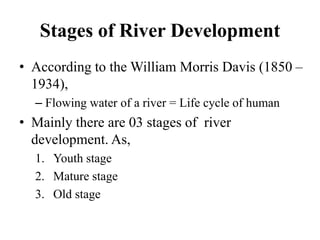
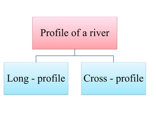
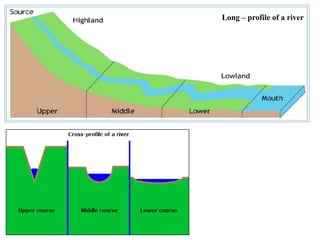
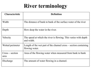
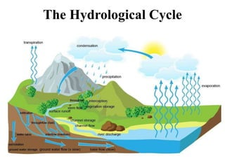
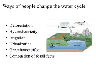
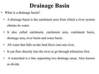
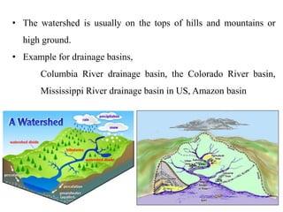
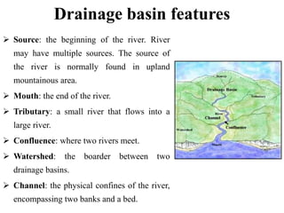
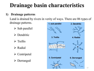
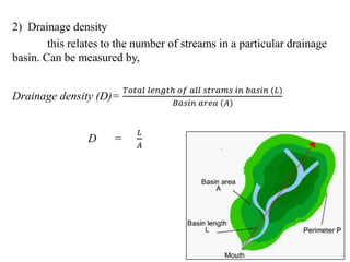
SlideShare a Scribd company logo
1
D.G. Nishavi Kaushalya Ranasinghe
B.A. (Hons) Geography
Department of Geography and Environmental Management
Sabaragamuwa University of Sri Lanka
 Rivers
 Water cycle
 Drainage basin
 Drainage basin characteristics
River
• What is a river?
– A river is a natural flowing watercourse, usually
freshwater, flowing towards an ocean, a lake, a sea,
or another river.
– Small rivers called by several names. Such as,
• Stream
• Creek
• Brook
• Rivulet
• Rill
• Rivers receive water from precipitation.
• Precipitation may receive as, rain, hail, snow
and sleet.
Rain Sleet
Hail Snow
 There are 04 types of elementary process in a river .
Such as,
◦ From rain water Ex: Mahaweli river
◦ From a spring Ex: Thames river
◦ Melting glaciers Ex: Seine river
◦ From a lake Ex: The Nile river
 Relationship between precipitation and the amount of
water in a river, known as discharge.
Stages of River Development
• According to the William Morris Davis (1850 –
1934),
– Flowing water of a river = Life cycle of human
• Mainly there are 03 stages of river
development. As,
1. Youth stage
2. Mature stage
3. Old stage
Profile of a river
Long - profile Cross - profile
Long – profile of a river
River terminology
Characteristic Definition
Width The distance of bank to bank of the surface water of the river
Depth How deep the water in the river.
Velocity The speed at which the river is flowing. This varies with depth
and width.
Wetted perimeter Length of the wet part of the channel cross – section containing
flowing water.
Cross – section
area
Area of the flowing water when measured from bank to bank
Discharge The amount of water flowing in a channel.
River A River B
The Hydrological Cycle
• The hydrological cycle also known as water cycle or H2O
cycle.
• It describes the continuous movement of water on, above
and below the surface of the Earth, contribution of solar
energy.
• The main components of the water cycle can describes
as,
– Evaporation/ Transpiration
– Condensation
– Precipitation
– Run – off
– Infiltration
Ways of people change the water cycle
• Deforestation
• Hydroelectricity
• Irrigation
• Urbanization
• Greenhouse effect
• Combustion of fossil fuels
13
Drainage Basin
• A drainage basin is the catchment area from which a river system
obtains its water.
• It also called catchment, catchment area, catchment basin,
drainage area, river basin and water basin.
• All water that falls on the land flows into one river.
• It can flow directly into the river or go through tributaries first.
• A watershed is a line separating two drainage areas. Also known
as divide.
• What is a drainage basin?
• The watershed is usually on the tops of hills and mountains or
high ground.
• Example for drainage basins,
Columbia River drainage basin, the Colorado River basin,
Mississippi River drainage basin in US, Amazon basin
Drainage basin features
 Source: the beginning of the river. River
may have multiple sources. The source of
the river is normally found in upland
mountainous area.
 Mouth: the end of the river.
 Tributary: a small river that flows into a
large river.
 Confluence: where two rivers meet.
 Watershed: the boarder between two
drainage basins.
 Channel: the physical confines of the river,
encompassing two banks and a bed.
Drainage basin characteristics
1) Drainage patterns
Land is drained by rivers in verity of ways. There are 06 types of
drainage patterns.
 Sub parallel
 Dendritic
 Trellis
 Radial
 Centripetal
 Derranged
17
2) Drainage density
this relates to the number of streams in a particular drainage
basin. Can be measured by,
Drainage density (D)=
𝑇𝑜𝑡𝑎𝑙 𝑙𝑒𝑛𝑔𝑡ℎ 𝑜𝑓 𝑎𝑙𝑙 𝑠𝑡𝑟𝑎𝑚𝑠 𝑖𝑛 𝑏𝑎𝑠𝑖𝑛 (𝐿)
𝐵𝑎𝑠𝑖𝑛 𝑎𝑟𝑒𝑎 (𝐴)
D =
𝐿
𝐴
18
3) Stream ordering
With the drainage density in a drainage basin can identify
stream order. As,
1 st order stream
Original source tributaries.
 2 nd order stream
the joining of first two
order streams.
 3 rd order stream
the merging of two second
order streams.
19
4) Vegetation factor
These are depended wholly or in part on the vegetation,
natural or cultivated, growing within the drainage – basin.
5) Climatic hydrologic factors.
This include temperature, humidity, rainfall and
evaporation. Hydrologic factors depended on the
operation of the hydrological cycle as well as run off
and underground water.
20
21

More Related Content

What's hot

Flood forecasting presentation final
Flood forecasting presentation finalFlood forecasting presentation final
Flood forecasting presentation final
Abir Mohammad
 
Ppt on terminology of ground water
Ppt on terminology  of ground waterPpt on terminology  of ground water
Ppt on terminology of ground water
Er. Zahir Gulamjilani Mahida
 
Groundwater Hydrology
Groundwater HydrologyGroundwater Hydrology
Groundwater Hydrology
Malla Reddy University
 
Groundwater Properties
Groundwater PropertiesGroundwater Properties
Groundwater Properties
Minhaz Hasan
 
Ground water zones
Ground water zonesGround water zones
Ground water zones
Laiba Sarwar
 
Chapter 3 Fetter Properties of Aquifers
Chapter 3 Fetter Properties of AquifersChapter 3 Fetter Properties of Aquifers
Chapter 3 Fetter Properties of Aquifers
Bakr Younis /Al-Azhar University – Gaza
 
REMOTE SENSING & GIS APPLICATIONS IN WATERSHED MANAGEMENT
REMOTE SENSING & GIS APPLICATIONS IN WATERSHED MANAGEMENT REMOTE SENSING & GIS APPLICATIONS IN WATERSHED MANAGEMENT
REMOTE SENSING & GIS APPLICATIONS IN WATERSHED MANAGEMENT
Sumant Diwakar
 
Vertical distribution of groundwater
Vertical distribution of groundwaterVertical distribution of groundwater
Vertical distribution of groundwater
Prof. A.Balasubramanian
 
Hyetograph and hydrograph analysis
Hyetograph and hydrograph analysisHyetograph and hydrograph analysis
Hyetograph and hydrograph analysis
vivek gami
 
Chapter 3 surface water hydrology
Chapter 3 surface water hydrologyChapter 3 surface water hydrology
Chapter 3 surface water hydrologyMohammed Salahat
 
radial flow pumping test
radial flow pumping testradial flow pumping test
radial flow pumping test
Fatonah Munsai
 
Application of GIS and RS in Watershed Management
Application of GIS and RS in Watershed ManagementApplication of GIS and RS in Watershed Management
Application of GIS and RS in Watershed Management
holegajendra
 
Hydrology (Runoff and factors affecting Run off)
Hydrology (Runoff and factors affecting Run off)Hydrology (Runoff and factors affecting Run off)
Hydrology (Runoff and factors affecting Run off)
Latif Hyder Wadho
 
Runoff final
Runoff finalRunoff final
Reservoir sedimentation
Reservoir sedimentationReservoir sedimentation
Reservoir sedimentation
Pramoda Raj
 
Runoff
RunoffRunoff
Flood risk mapping using GIS and remote sensing
Flood risk mapping using GIS and remote sensingFlood risk mapping using GIS and remote sensing
Flood risk mapping using GIS and remote sensing
Rohan Tuteja
 
identification of ground water potential zones using gis and remote sensing
identification of ground water potential zones using gis and remote sensingidentification of ground water potential zones using gis and remote sensing
identification of ground water potential zones using gis and remote sensing
tp jayamohan
 
Sea water intrusion
Sea water intrusion Sea water intrusion
Sea water intrusion
Prashant Katti
 
Vertical distribution of groundwater
Vertical distribution of groundwaterVertical distribution of groundwater
Vertical distribution of groundwater
Pramoda Raj
 

What's hot (20)

Flood forecasting presentation final
Flood forecasting presentation finalFlood forecasting presentation final
Flood forecasting presentation final
 
Ppt on terminology of ground water
Ppt on terminology  of ground waterPpt on terminology  of ground water
Ppt on terminology of ground water
 
Groundwater Hydrology
Groundwater HydrologyGroundwater Hydrology
Groundwater Hydrology
 
Groundwater Properties
Groundwater PropertiesGroundwater Properties
Groundwater Properties
 
Ground water zones
Ground water zonesGround water zones
Ground water zones
 
Chapter 3 Fetter Properties of Aquifers
Chapter 3 Fetter Properties of AquifersChapter 3 Fetter Properties of Aquifers
Chapter 3 Fetter Properties of Aquifers
 
REMOTE SENSING & GIS APPLICATIONS IN WATERSHED MANAGEMENT
REMOTE SENSING & GIS APPLICATIONS IN WATERSHED MANAGEMENT REMOTE SENSING & GIS APPLICATIONS IN WATERSHED MANAGEMENT
REMOTE SENSING & GIS APPLICATIONS IN WATERSHED MANAGEMENT
 
Vertical distribution of groundwater
Vertical distribution of groundwaterVertical distribution of groundwater
Vertical distribution of groundwater
 
Hyetograph and hydrograph analysis
Hyetograph and hydrograph analysisHyetograph and hydrograph analysis
Hyetograph and hydrograph analysis
 
Chapter 3 surface water hydrology
Chapter 3 surface water hydrologyChapter 3 surface water hydrology
Chapter 3 surface water hydrology
 
radial flow pumping test
radial flow pumping testradial flow pumping test
radial flow pumping test
 
Application of GIS and RS in Watershed Management
Application of GIS and RS in Watershed ManagementApplication of GIS and RS in Watershed Management
Application of GIS and RS in Watershed Management
 
Hydrology (Runoff and factors affecting Run off)
Hydrology (Runoff and factors affecting Run off)Hydrology (Runoff and factors affecting Run off)
Hydrology (Runoff and factors affecting Run off)
 
Runoff final
Runoff finalRunoff final
Runoff final
 
Reservoir sedimentation
Reservoir sedimentationReservoir sedimentation
Reservoir sedimentation
 
Runoff
RunoffRunoff
Runoff
 
Flood risk mapping using GIS and remote sensing
Flood risk mapping using GIS and remote sensingFlood risk mapping using GIS and remote sensing
Flood risk mapping using GIS and remote sensing
 
identification of ground water potential zones using gis and remote sensing
identification of ground water potential zones using gis and remote sensingidentification of ground water potential zones using gis and remote sensing
identification of ground water potential zones using gis and remote sensing
 
Sea water intrusion
Sea water intrusion Sea water intrusion
Sea water intrusion
 
Vertical distribution of groundwater
Vertical distribution of groundwaterVertical distribution of groundwater
Vertical distribution of groundwater
 

Similar to Rivers and drainage basins n

Fluvial Process And Related Land Forms
Fluvial Process And Related Land Forms Fluvial Process And Related Land Forms
Fluvial Process And Related Land Forms sileshi
 
Unit6_RIVERS.ppt
Unit6_RIVERS.pptUnit6_RIVERS.ppt
Unit6_RIVERS.ppt
HazelValderama1
 
River
RiverRiver
Unit 12 River training work.pdf
Unit 12 River training work.pdfUnit 12 River training work.pdf
Unit 12 River training work.pdf
BittuRajkumar
 
Hydrology and Fluvial Geo morphology for CAMBRIDGE AS level
Hydrology and Fluvial Geo morphology for CAMBRIDGE AS level Hydrology and Fluvial Geo morphology for CAMBRIDGE AS level
Hydrology and Fluvial Geo morphology for CAMBRIDGE AS level
Yonas Gemeda
 
CH-1 Introduction to River Hydraulics.pdf
CH-1 Introduction to River Hydraulics.pdfCH-1 Introduction to River Hydraulics.pdf
CH-1 Introduction to River Hydraulics.pdf
DanielSolomon58
 
Humid geomorphic environment
Humid geomorphic environmentHumid geomorphic environment
Humid geomorphic environment
Md. Nazir Hossain
 
Fluvial morphology
Fluvial morphologyFluvial morphology
Fluvial morphology
Kella Randolph
 
Civil 4th year-2.pptx
Civil 4th year-2.pptxCivil 4th year-2.pptx
Civil 4th year-2.pptx
Amanuel Beza
 
Tuesday may 3 surface waters
Tuesday may 3 surface watersTuesday may 3 surface waters
Tuesday may 3 surface waters
Mau Dijamco
 
Rivers presentation
Rivers presentationRivers presentation
Rivers presentationZahid Rao
 
CAMBRIDGE AS GEOGRAPHY REVISION: HYDROLOGY AND FLUVIAL GEOMORPHOLOGY - 1.3 RI...
CAMBRIDGE AS GEOGRAPHY REVISION: HYDROLOGY AND FLUVIAL GEOMORPHOLOGY - 1.3 RI...CAMBRIDGE AS GEOGRAPHY REVISION: HYDROLOGY AND FLUVIAL GEOMORPHOLOGY - 1.3 RI...
CAMBRIDGE AS GEOGRAPHY REVISION: HYDROLOGY AND FLUVIAL GEOMORPHOLOGY - 1.3 RI...
George Dumitrache
 
1.3 river channel processes
1.3 river channel processes1.3 river channel processes
1.3 river channel processes
Kylie Kemp
 
River erosion
River erosionRiver erosion
River erosion
Vasu Goel
 
UNIT. 4. Rivers.pptx, river system, tribuary
UNIT. 4. Rivers.pptx, river system, tribuaryUNIT. 4. Rivers.pptx, river system, tribuary
UNIT. 4. Rivers.pptx, river system, tribuary
AbdinasirAhmedMohame2
 
River
RiverRiver
River
dharmikdk
 
Running water as an agent of Erosion
Running water as an agent of ErosionRunning water as an agent of Erosion
Running water as an agent of Erosion
Rakesh S
 

Similar to Rivers and drainage basins n (20)

Fluvial Process And Related Land Forms
Fluvial Process And Related Land Forms Fluvial Process And Related Land Forms
Fluvial Process And Related Land Forms
 
Unit6_RIVERS.ppt
Unit6_RIVERS.pptUnit6_RIVERS.ppt
Unit6_RIVERS.ppt
 
Hydrology
HydrologyHydrology
Hydrology
 
River
RiverRiver
River
 
Unit 12 River training work.pdf
Unit 12 River training work.pdfUnit 12 River training work.pdf
Unit 12 River training work.pdf
 
Hydrology and Fluvial Geo morphology for CAMBRIDGE AS level
Hydrology and Fluvial Geo morphology for CAMBRIDGE AS level Hydrology and Fluvial Geo morphology for CAMBRIDGE AS level
Hydrology and Fluvial Geo morphology for CAMBRIDGE AS level
 
CH-1 Introduction to River Hydraulics.pdf
CH-1 Introduction to River Hydraulics.pdfCH-1 Introduction to River Hydraulics.pdf
CH-1 Introduction to River Hydraulics.pdf
 
Humid geomorphic environment
Humid geomorphic environmentHumid geomorphic environment
Humid geomorphic environment
 
Fluvial morphology
Fluvial morphologyFluvial morphology
Fluvial morphology
 
Civil 4th year-2.pptx
Civil 4th year-2.pptxCivil 4th year-2.pptx
Civil 4th year-2.pptx
 
Tuesday may 3 surface waters
Tuesday may 3 surface watersTuesday may 3 surface waters
Tuesday may 3 surface waters
 
Rivers presentation
Rivers presentationRivers presentation
Rivers presentation
 
CAMBRIDGE AS GEOGRAPHY REVISION: HYDROLOGY AND FLUVIAL GEOMORPHOLOGY - 1.3 RI...
CAMBRIDGE AS GEOGRAPHY REVISION: HYDROLOGY AND FLUVIAL GEOMORPHOLOGY - 1.3 RI...CAMBRIDGE AS GEOGRAPHY REVISION: HYDROLOGY AND FLUVIAL GEOMORPHOLOGY - 1.3 RI...
CAMBRIDGE AS GEOGRAPHY REVISION: HYDROLOGY AND FLUVIAL GEOMORPHOLOGY - 1.3 RI...
 
1.3 river channel processes
1.3 river channel processes1.3 river channel processes
1.3 river channel processes
 
Uses of Rivers
Uses of Rivers Uses of Rivers
Uses of Rivers
 
River erosion
River erosionRiver erosion
River erosion
 
UNIT. 4. Rivers.pptx, river system, tribuary
UNIT. 4. Rivers.pptx, river system, tribuaryUNIT. 4. Rivers.pptx, river system, tribuary
UNIT. 4. Rivers.pptx, river system, tribuary
 
Rivers
RiversRivers
Rivers
 
River
RiverRiver
River
 
Running water as an agent of Erosion
Running water as an agent of ErosionRunning water as an agent of Erosion
Running water as an agent of Erosion
 

Recently uploaded

Synthetic Fiber Construction in lab .pptx
Synthetic Fiber Construction in lab .pptxSynthetic Fiber Construction in lab .pptx
Synthetic Fiber Construction in lab .pptx
Pavel ( NSTU)
 
CACJapan - GROUP Presentation 1- Wk 4.pdf
CACJapan - GROUP Presentation 1- Wk 4.pdfCACJapan - GROUP Presentation 1- Wk 4.pdf
CACJapan - GROUP Presentation 1- Wk 4.pdf
camakaiclarkmusic
 
Home assignment II on Spectroscopy 2024 Answers.pdf
Home assignment II on Spectroscopy 2024 Answers.pdfHome assignment II on Spectroscopy 2024 Answers.pdf
Home assignment II on Spectroscopy 2024 Answers.pdf
Tamralipta Mahavidyalaya
 
Biological Screening of Herbal Drugs in detailed.
Biological Screening of Herbal Drugs in detailed.Biological Screening of Herbal Drugs in detailed.
Biological Screening of Herbal Drugs in detailed.
Ashokrao Mane college of Pharmacy Peth-Vadgaon
 
Supporting (UKRI) OA monographs at Salford.pptx
Supporting (UKRI) OA monographs at Salford.pptxSupporting (UKRI) OA monographs at Salford.pptx
Supporting (UKRI) OA monographs at Salford.pptx
Jisc
 
2024.06.01 Introducing a competency framework for languag learning materials ...
2024.06.01 Introducing a competency framework for languag learning materials ...2024.06.01 Introducing a competency framework for languag learning materials ...
2024.06.01 Introducing a competency framework for languag learning materials ...
Sandy Millin
 
1.4 modern child centered education - mahatma gandhi-2.pptx
1.4 modern child centered education - mahatma gandhi-2.pptx1.4 modern child centered education - mahatma gandhi-2.pptx
1.4 modern child centered education - mahatma gandhi-2.pptx
JosvitaDsouza2
 
Honest Reviews of Tim Han LMA Course Program.pptx
Honest Reviews of Tim Han LMA Course Program.pptxHonest Reviews of Tim Han LMA Course Program.pptx
Honest Reviews of Tim Han LMA Course Program.pptx
timhan337
 
Operation Blue Star - Saka Neela Tara
Operation Blue Star   -  Saka Neela TaraOperation Blue Star   -  Saka Neela Tara
Operation Blue Star - Saka Neela Tara
Balvir Singh
 
The Roman Empire A Historical Colossus.pdf
The Roman Empire A Historical Colossus.pdfThe Roman Empire A Historical Colossus.pdf
The Roman Empire A Historical Colossus.pdf
kaushalkr1407
 
Lapbook sobre os Regimes Totalitários.pdf
Lapbook sobre os Regimes Totalitários.pdfLapbook sobre os Regimes Totalitários.pdf
Lapbook sobre os Regimes Totalitários.pdf
Jean Carlos Nunes Paixão
 
The geography of Taylor Swift - some ideas
The geography of Taylor Swift - some ideasThe geography of Taylor Swift - some ideas
The geography of Taylor Swift - some ideas
GeoBlogs
 
A Strategic Approach: GenAI in Education
A Strategic Approach: GenAI in EducationA Strategic Approach: GenAI in Education
A Strategic Approach: GenAI in Education
Peter Windle
 
Thesis Statement for students diagnonsed withADHD.ppt
Thesis Statement for students diagnonsed withADHD.pptThesis Statement for students diagnonsed withADHD.ppt
Thesis Statement for students diagnonsed withADHD.ppt
EverAndrsGuerraGuerr
 
Acetabularia Information For Class 9 .docx
Acetabularia Information For Class 9  .docxAcetabularia Information For Class 9  .docx
Acetabularia Information For Class 9 .docx
vaibhavrinwa19
 
aaaaaaaaaaaaaaaaaaaaaaaaaaaaaaaaaaaaaaaaa
aaaaaaaaaaaaaaaaaaaaaaaaaaaaaaaaaaaaaaaaaaaaaaaaaaaaaaaaaaaaaaaaaaaaaaaaaaaaaaaaaa
aaaaaaaaaaaaaaaaaaaaaaaaaaaaaaaaaaaaaaaaa
siemaillard
 
Embracing GenAI - A Strategic Imperative
Embracing GenAI - A Strategic ImperativeEmbracing GenAI - A Strategic Imperative
Embracing GenAI - A Strategic Imperative
Peter Windle
 
Welcome to TechSoup New Member Orientation and Q&A (May 2024).pdf
Welcome to TechSoup   New Member Orientation and Q&A (May 2024).pdfWelcome to TechSoup   New Member Orientation and Q&A (May 2024).pdf
Welcome to TechSoup New Member Orientation and Q&A (May 2024).pdf
TechSoup
 
The French Revolution Class 9 Study Material pdf free download
The French Revolution Class 9 Study Material pdf free downloadThe French Revolution Class 9 Study Material pdf free download
The French Revolution Class 9 Study Material pdf free download
Vivekanand Anglo Vedic Academy
 
Digital Tools and AI for Teaching Learning and Research
Digital Tools and AI for Teaching Learning and ResearchDigital Tools and AI for Teaching Learning and Research
Digital Tools and AI for Teaching Learning and Research
Vikramjit Singh
 

Recently uploaded (20)

Synthetic Fiber Construction in lab .pptx
Synthetic Fiber Construction in lab .pptxSynthetic Fiber Construction in lab .pptx
Synthetic Fiber Construction in lab .pptx
 
CACJapan - GROUP Presentation 1- Wk 4.pdf
CACJapan - GROUP Presentation 1- Wk 4.pdfCACJapan - GROUP Presentation 1- Wk 4.pdf
CACJapan - GROUP Presentation 1- Wk 4.pdf
 
Home assignment II on Spectroscopy 2024 Answers.pdf
Home assignment II on Spectroscopy 2024 Answers.pdfHome assignment II on Spectroscopy 2024 Answers.pdf
Home assignment II on Spectroscopy 2024 Answers.pdf
 
Biological Screening of Herbal Drugs in detailed.
Biological Screening of Herbal Drugs in detailed.Biological Screening of Herbal Drugs in detailed.
Biological Screening of Herbal Drugs in detailed.
 
Supporting (UKRI) OA monographs at Salford.pptx
Supporting (UKRI) OA monographs at Salford.pptxSupporting (UKRI) OA monographs at Salford.pptx
Supporting (UKRI) OA monographs at Salford.pptx
 
2024.06.01 Introducing a competency framework for languag learning materials ...
2024.06.01 Introducing a competency framework for languag learning materials ...2024.06.01 Introducing a competency framework for languag learning materials ...
2024.06.01 Introducing a competency framework for languag learning materials ...
 
1.4 modern child centered education - mahatma gandhi-2.pptx
1.4 modern child centered education - mahatma gandhi-2.pptx1.4 modern child centered education - mahatma gandhi-2.pptx
1.4 modern child centered education - mahatma gandhi-2.pptx
 
Honest Reviews of Tim Han LMA Course Program.pptx
Honest Reviews of Tim Han LMA Course Program.pptxHonest Reviews of Tim Han LMA Course Program.pptx
Honest Reviews of Tim Han LMA Course Program.pptx
 
Operation Blue Star - Saka Neela Tara
Operation Blue Star   -  Saka Neela TaraOperation Blue Star   -  Saka Neela Tara
Operation Blue Star - Saka Neela Tara
 
The Roman Empire A Historical Colossus.pdf
The Roman Empire A Historical Colossus.pdfThe Roman Empire A Historical Colossus.pdf
The Roman Empire A Historical Colossus.pdf
 
Lapbook sobre os Regimes Totalitários.pdf
Lapbook sobre os Regimes Totalitários.pdfLapbook sobre os Regimes Totalitários.pdf
Lapbook sobre os Regimes Totalitários.pdf
 
The geography of Taylor Swift - some ideas
The geography of Taylor Swift - some ideasThe geography of Taylor Swift - some ideas
The geography of Taylor Swift - some ideas
 
A Strategic Approach: GenAI in Education
A Strategic Approach: GenAI in EducationA Strategic Approach: GenAI in Education
A Strategic Approach: GenAI in Education
 
Thesis Statement for students diagnonsed withADHD.ppt
Thesis Statement for students diagnonsed withADHD.pptThesis Statement for students diagnonsed withADHD.ppt
Thesis Statement for students diagnonsed withADHD.ppt
 
Acetabularia Information For Class 9 .docx
Acetabularia Information For Class 9  .docxAcetabularia Information For Class 9  .docx
Acetabularia Information For Class 9 .docx
 
aaaaaaaaaaaaaaaaaaaaaaaaaaaaaaaaaaaaaaaaa
aaaaaaaaaaaaaaaaaaaaaaaaaaaaaaaaaaaaaaaaaaaaaaaaaaaaaaaaaaaaaaaaaaaaaaaaaaaaaaaaaa
aaaaaaaaaaaaaaaaaaaaaaaaaaaaaaaaaaaaaaaaa
 
Embracing GenAI - A Strategic Imperative
Embracing GenAI - A Strategic ImperativeEmbracing GenAI - A Strategic Imperative
Embracing GenAI - A Strategic Imperative
 
Welcome to TechSoup New Member Orientation and Q&A (May 2024).pdf
Welcome to TechSoup   New Member Orientation and Q&A (May 2024).pdfWelcome to TechSoup   New Member Orientation and Q&A (May 2024).pdf
Welcome to TechSoup New Member Orientation and Q&A (May 2024).pdf
 
The French Revolution Class 9 Study Material pdf free download
The French Revolution Class 9 Study Material pdf free downloadThe French Revolution Class 9 Study Material pdf free download
The French Revolution Class 9 Study Material pdf free download
 
Digital Tools and AI for Teaching Learning and Research
Digital Tools and AI for Teaching Learning and ResearchDigital Tools and AI for Teaching Learning and Research
Digital Tools and AI for Teaching Learning and Research
 

Rivers and drainage basins n

  • 1. 1 D.G. Nishavi Kaushalya Ranasinghe B.A. (Hons) Geography Department of Geography and Environmental Management Sabaragamuwa University of Sri Lanka
  • 2.  Rivers  Water cycle  Drainage basin  Drainage basin characteristics
  • 3. River • What is a river? – A river is a natural flowing watercourse, usually freshwater, flowing towards an ocean, a lake, a sea, or another river. – Small rivers called by several names. Such as, • Stream • Creek • Brook • Rivulet • Rill
  • 4. • Rivers receive water from precipitation. • Precipitation may receive as, rain, hail, snow and sleet. Rain Sleet Hail Snow
  • 5.  There are 04 types of elementary process in a river . Such as, ◦ From rain water Ex: Mahaweli river ◦ From a spring Ex: Thames river ◦ Melting glaciers Ex: Seine river ◦ From a lake Ex: The Nile river  Relationship between precipitation and the amount of water in a river, known as discharge.
  • 6. Stages of River Development • According to the William Morris Davis (1850 – 1934), – Flowing water of a river = Life cycle of human • Mainly there are 03 stages of river development. As, 1. Youth stage 2. Mature stage 3. Old stage
  • 7. Profile of a river Long - profile Cross - profile
  • 8. Long – profile of a river
  • 9. River terminology Characteristic Definition Width The distance of bank to bank of the surface water of the river Depth How deep the water in the river. Velocity The speed at which the river is flowing. This varies with depth and width. Wetted perimeter Length of the wet part of the channel cross – section containing flowing water. Cross – section area Area of the flowing water when measured from bank to bank Discharge The amount of water flowing in a channel.
  • 12. • The hydrological cycle also known as water cycle or H2O cycle. • It describes the continuous movement of water on, above and below the surface of the Earth, contribution of solar energy. • The main components of the water cycle can describes as, – Evaporation/ Transpiration – Condensation – Precipitation – Run – off – Infiltration
  • 13. Ways of people change the water cycle • Deforestation • Hydroelectricity • Irrigation • Urbanization • Greenhouse effect • Combustion of fossil fuels 13
  • 14. Drainage Basin • A drainage basin is the catchment area from which a river system obtains its water. • It also called catchment, catchment area, catchment basin, drainage area, river basin and water basin. • All water that falls on the land flows into one river. • It can flow directly into the river or go through tributaries first. • A watershed is a line separating two drainage areas. Also known as divide. • What is a drainage basin?
  • 15. • The watershed is usually on the tops of hills and mountains or high ground. • Example for drainage basins, Columbia River drainage basin, the Colorado River basin, Mississippi River drainage basin in US, Amazon basin
  • 16. Drainage basin features  Source: the beginning of the river. River may have multiple sources. The source of the river is normally found in upland mountainous area.  Mouth: the end of the river.  Tributary: a small river that flows into a large river.  Confluence: where two rivers meet.  Watershed: the boarder between two drainage basins.  Channel: the physical confines of the river, encompassing two banks and a bed.
  • 17. Drainage basin characteristics 1) Drainage patterns Land is drained by rivers in verity of ways. There are 06 types of drainage patterns.  Sub parallel  Dendritic  Trellis  Radial  Centripetal  Derranged 17
  • 18. 2) Drainage density this relates to the number of streams in a particular drainage basin. Can be measured by, Drainage density (D)= 𝑇𝑜𝑡𝑎𝑙 𝑙𝑒𝑛𝑔𝑡ℎ 𝑜𝑓 𝑎𝑙𝑙 𝑠𝑡𝑟𝑎𝑚𝑠 𝑖𝑛 𝑏𝑎𝑠𝑖𝑛 (𝐿) 𝐵𝑎𝑠𝑖𝑛 𝑎𝑟𝑒𝑎 (𝐴) D = 𝐿 𝐴 18
  • 19. 3) Stream ordering With the drainage density in a drainage basin can identify stream order. As, 1 st order stream Original source tributaries.  2 nd order stream the joining of first two order streams.  3 rd order stream the merging of two second order streams. 19
  • 20. 4) Vegetation factor These are depended wholly or in part on the vegetation, natural or cultivated, growing within the drainage – basin. 5) Climatic hydrologic factors. This include temperature, humidity, rainfall and evaporation. Hydrologic factors depended on the operation of the hydrological cycle as well as run off and underground water. 20
  • 21. 21

Editor's Notes

  1. Rarely, rivers flow into the ground and dry up completely at the end of its course, without reaching another body of water.
  2. The process of water loss from plants through stomata (transpiration)
  3. Amazon basin same size as Australia. It drains west to east.