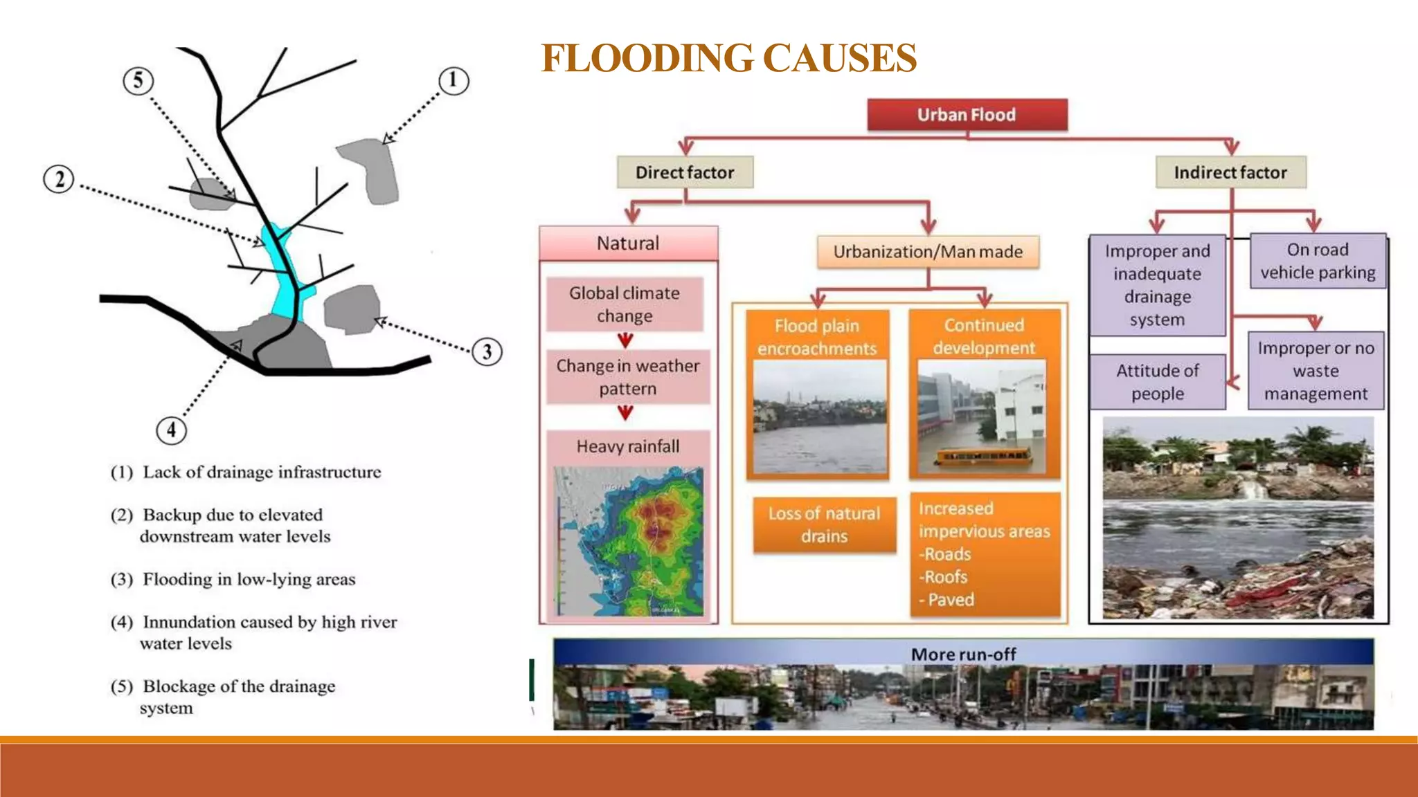
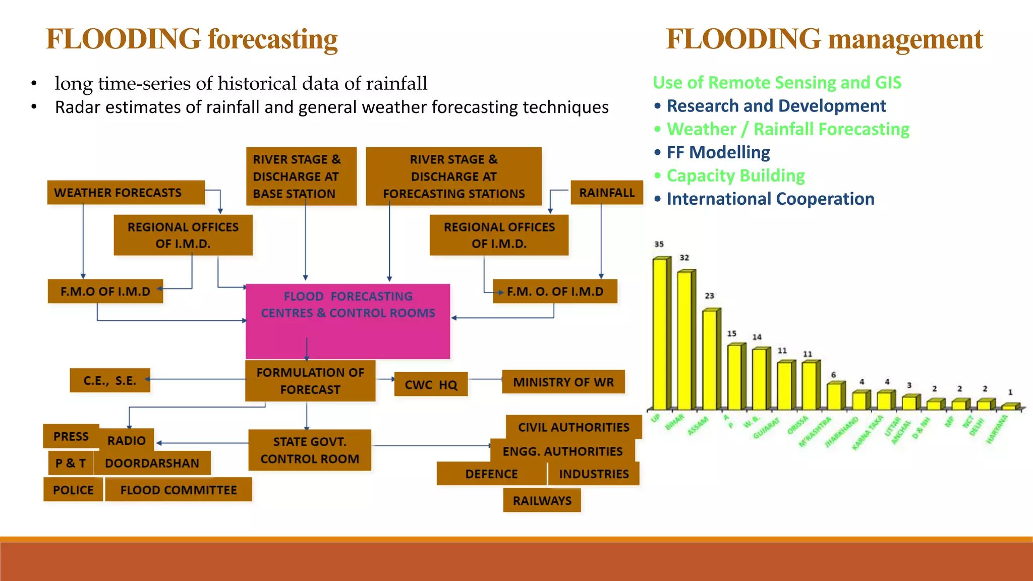
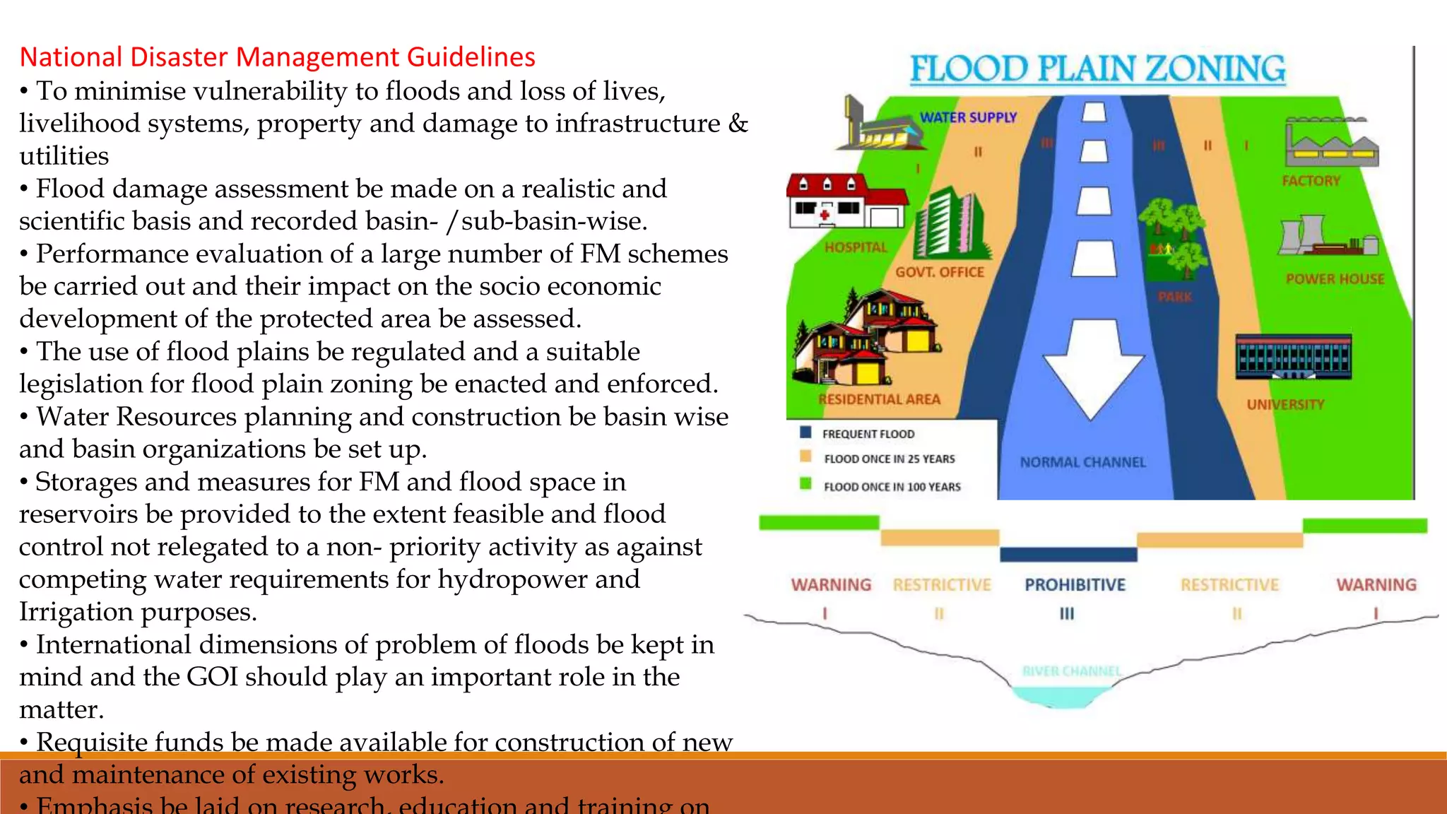
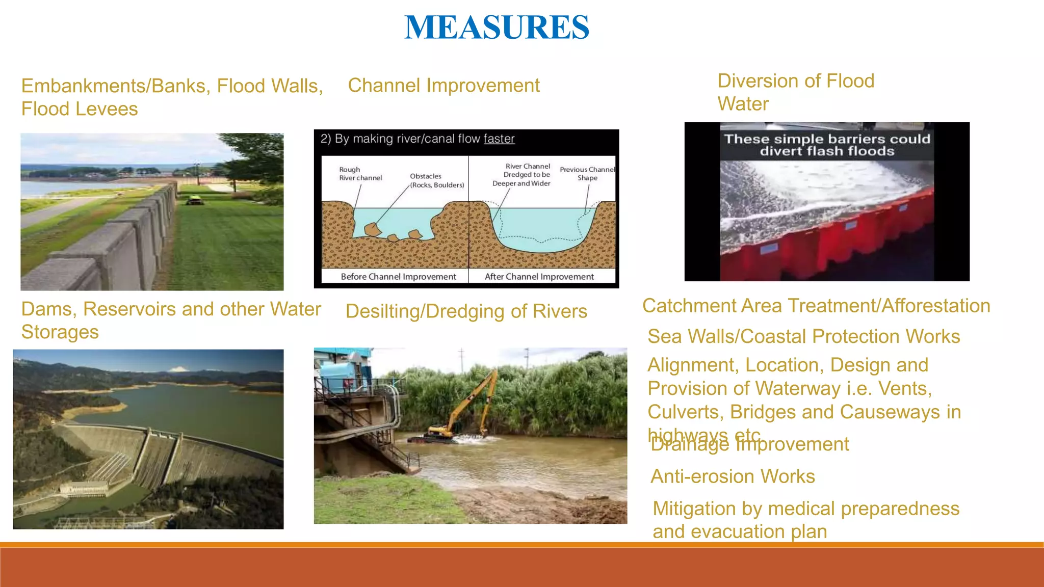
FLOOD
A flood is submerging of normally dry land by an overflow of
water. It can be localized event affecting a small area of land or
a very big disaster that can have impact on whole island or river
basin.
River floods • Most common type of flood event
Flash floods • Extreme version of a river flooding event
Area or
urban
flooding
• Occurs when low lying impenetrable
ground becomes saturated
Area or
urban
flooding
• Caused by high sea tidal surges and
waves
Weather events
• Heavy rainfall
• High tide with
storm
• Climate
change
Poor
maintenance
• Sewer
networks
• Insufficient
drainage
• Inadequate
maintenance
of water
course
Development/
planning issues
• Inappropriate
development
in flood plains
• Rain water
runoff
• Badly
designed
flood defence
mechanisms.
URBAN FLOODS
TYPE OF FLOOD
Duration of flood
• Slow-Onset Floods: can last for longer period
• Rapid-Onset Floods: shorter period like one or two days.
• Flash Floods: Flash Floods may occur within minutes or a
few hours after heavy rainfall, tropical storm, failure of
dams or levees or releases of ice dams.
FLOODING CAUSES
FLOODING
CAUSES
There are various causes
resulting in flooding :-
Collapse of bridgeTrain lines damaged
Human Loss
Property Loss
Affects the Major
Roads
Disruption of Air /
Train / Bus services
Spread of Water-
borne
Communicable
Diseases
Communication
Breakdown
Increase in Air /
Water Pollution
Electricity Supply Cut
off
Economic and Social
Disruption
FLOODING EFFECTS
Heavy damage to property Infrastructure affected
FLOODING issues India
Floods cause damage to houses,
industries, public utilities and property
resulting in huge economic losses, apart
from loss of lives.
•Non-availability of
close contour maps
and digital elevation
models of flood prone
Areas.
•Flood plain zoning
regulations have not
been enacted and
enforced by most of the
States
•Implementation of the
flood proofing measures
such as raising of villages,
constructions of floods
shelters is not proper.
•Reservoirs is often
carried out disregarding
flood moderation
aspects.
•Rivers erode a significant
amount of land every
year. Conventional anti-
erosion measures require
high investment.
Lacks public participation
and awareness
Flood forecasting and
warning not proper
There is no proper
documentation about
floods, their impact
GAPS IN FLOOD MANAGEMENT
DM 2005 guidelines recognize the fact that there is a lack of
coordination
The financial aspects for implementation
The timelines proposed for the Implementation- long gestation period.
Institutional related to flooding management
National Disaster Management Authority
The Central Flood Control Board (CFCB)
Central Water Commission
Ganga Flood Control Board
Brahmaputra Board
India Meteorological Department
National Remote Sensing Agency
National Centre for Medium Range
Weather Forecasting
River Basin Organisations
National Flood Management Institute
FLOODING forecasting
• long time-series of historical data of rainfall
• Radar estimates of rainfall and general weather forecasting techniques
FLOODING management
Use of Remote Sensing and GIS
• Research and Development
• Weather / Rainfall Forecasting
• FF Modelling
• Capacity Building
• International Cooperation
National Disaster Management Guidelines
• To minimise vulnerability to floods and loss of lives,
livelihood systems, property and damage to infrastructure &
utilities
• Flood damage assessment be made on a realistic and
scientific basis and recorded basin- /sub-basin-wise.
• Performance evaluation of a large number of FM schemes
be carried out and their impact on the socio economic
development of the protected area be assessed.
• The use of flood plains be regulated and a suitable
legislation for flood plain zoning be enacted and enforced.
• Water Resources planning and construction be basin wise
and basin organizations be set up.
• Storages and measures for FM and flood space in
reservoirs be provided to the extent feasible and flood
control not relegated to a non- priority activity as against
competing water requirements for hydropower and
Irrigation purposes.
• International dimensions of problem of floods be kept in
mind and the GOI should play an important role in the
matter.
• Requisite funds be made available for construction of new
and maintenance of existing works.
2012 BRAHAMAPUTRAFLOOD
In July 2012, Brahmaputra flooded since
it was natural but it grabs a spot at
number 2 and eye-catching event
because the main area which was
affected included Kaziranga National
Park, a park which is the natural habitat
of Rhinos. It cause a death of 540 animals
including 13 Rhinos. The main reasons
behind this calamity is the deforestation
Embankments/Banks, Flood Walls,
Flood Levees
Dams, Reservoirs and other Water
Storages
Channel Improvement
Desilting/Dredging of Rivers
Drainage Improvement
Diversion of Flood
Water
Catchment Area Treatment/Afforestation
Anti-erosion Works
Sea Walls/Coastal Protection Works
Alignment, Location, Design and
Provision of Waterway i.e. Vents,
Culverts, Bridges and Causeways in
highways etc.
MEASURES
Mitigation by medical preparedness
and evacuation plan
Housing
Infrastructure
 Recommendations on Retrofitting
and renovation of buildings
 Improving the condition of informal
settlements
 Minimum access roads for clumsy
settlements
Service
Infrastructure
 Improving sanitation
 Increasing the capacity of s.w.d
 Upgrading emergency services
 Enforcing on site fire fighting
capability in hazardous industries
Land use policies  Improvement and protection of
landfill sites
 Decongestion
 Control on land reclamation
 Shifting of storage and hazardous
units from residential areas
• Increasing Adaptive capacity of the construction sector which
means repair the damaged quickly as possible
• Reducing indirect losses from flooding by provision of
insurance.
MITIGATION
•Upgraded Emergency
Control Room/ early
warning system as
message alerts from
rain guage
•Bores along with the
storm water drains to
increase ground water
table, Percolation tanks
•Search and Rescue
Teams/ emergency
parking
•Equipment
upgradation/ rain
gauge installation
Hospital arrangements
Planting and preserving
of mangroves
•Fire Brigade Control
Rooms
Cleaning of Mithi river
EXISTING STRATEGIES
Report drafted in 2004 provides broad guidelines to exercise
mitigation strategies:
• Every department should have appropriate funds for
preparedness.
• The projects incorporating mitigation measures, in their
plans, should be given priority over the other projects to
be approved.
• Involvement of the general public and generation of
awareness
• A close interaction should be established between the
“corporate sector, non-governmental organizations and
the media,”
• disaster managers at different levels of the government
should be appropriately “trained.
• during the emergencies, arrangements should be made
to share resources such as power, food and funds
amongst the states.
• All the vital buildings in flood prone zones they should be
strengthened or remodeled to deal with the expected
disasters in the future.
Major recommendations in the BRIMSTOWAD report, 1993
• Removal of obstructions, to rehabilitate old/dilapidated SWD
system in City and augmentation of SWD in certain stretches,
to remove encroachments.
• To change the design criteria from 25 mm/hr to 50 mm/hr
rainfall intensity and coefficient of runoff as 1.00 from earlier
value of 0.50.
• To augment the SWD system with tidal effects and widen.
• To augment railway culverts at various flood prone areas
• To provide pumping stations at the city outfalls at Haji Ali,
Love Grove and Worli.
Role of the Government
Decentralizing the decision-making process to the local
level to ensure prompt action.
Reframing existing framework
The Role of the Private Sector:
Public private partnership in mitigation
Non governmental organization.
National Disaster Management Guidelines.
Structure of Guidelines
Chapter 1 provides an introductory review about how urban flooding is different from riverine flooding, factors contributing to urban
flooding, different weather systems in India, variability of rainfall, different city scenarios and genesis of the Guidelines.
Chapter 2 provides present status of the institutional framework at the national, state and the local levels, role of central ministries
and departments, states and urban local bodies and other local authorities/organizations.
Chapter 3 discusses present status of flood forecasting, warning and communication system. The gaps are identified and
recommendations have been made for enhancing capabilities, using state-of-the-art equipment.
Chapter 4 reviews the existing international and national status, practices for the design and maintenance of urban drainage
systems. Gaps have been identified and recommendations made to develop efficient drainage systems with improved operations
and maintenance actions.
Chapter 5 covers urban flood risk management issues, vulnerability analysis, risk assessment and hazard mapping, damage
assessment and data generation options, etc.
Chapter 6 looks at town planning concepts, central and state legislations and a gist of relevant provisions under layout
approvals and building permissions.
Chapter 7 deals with response actions including putting in place an incident response system.
Chapter 8 deals with capacity development at institutional and community levels, awareness generation and the role of
different stakeholders and the need for proper documentation of events and actions.
GUIDELINES
Chapter 9 deals with implementation strategies, mainstreaming of DM into development planning, role of nodal ministry,
mobilization of financial resources and implementation methodology, etc.
Chapter 10 provides the chapter-wise summary of action points.
2.Under AMRUT mission Urban Flooding Standard Operating Procedure(SOP) document has been prepared.
LANDSLIDE
• A landslide is a downward or
outward movement of soil,
rock or vegetation, under the
influence of gravity.
• Three distinct physical events
occur during a landslide: the
initial slope failure, the
subsequent transport, and the
final deposition of the slide
materials.
TYPES OF LANDSLIDES
a) Rotational slides: move along a surface of
rupture that is curved and concave
b) Translational slides occurs when the failure
surface is approximately flat
c) Rock Fall: Free falling of detached bodies of
bedrock (boulders) from a cliff.
d) Rock toppling occurs when one or more
rock units rotate about their base.
e) Lateral spreading occurs when the soil mass
spreads laterally and crack happen.
f) Debris Flow: Down slope movement
• Landslides are a natural hazard that affect at least 15 per
cent of the land area of our country, covering an area of
more than 0.49 million sq. km,.
• There are more than 25 river dam projects on the river Ganga
and its tributaries in the hills alone. A number of tunnels and
towers have inflicted heavy damages to the slopes
Landslide Hazard Zonation Mapping
LANDSLIDE
EFFECTS AND LOSSES DUE TO LANDSLIDES
A) Direct Effects:
Physical Damage-Debris may block roads, supply lines
(telecommunication, electricity, water, etc.) and
waterways.
Causalities- deaths and injuries to people and animals.
B) Indirect Effects:
Influence of landslides in dam safety- failure of
the slopes bordering the reservoir, Flooding caused by
movements of large masses of soil into the reservoir.
13
Landslides and flooding- Debris flow can cause
flooding by blocking valleys and stream channels,
C) Direct losses:
Loss of life, property, infrastructure and lifeline
facilities, etc.
D) Indirect losses:
Loss in productivity of agricultural or forest lands,
Reduced property values, Loss of revenue, Increased
cost, Adverse effect on water quality and Loss of
human productivity,
LANDSLIDE FOCUS AREA FOR LANDSLIDE
Hazard
Zonation
Mapping.
Response.
Geological
and
Geotechnical
Investigation.
Landslide
Risk
Treatment.
Regulation
and
Enforcement.
Research and
Development.
Preparation of
Landslide
Management
Plans.
Monitoring
and
Forecasting
of
Landslides.
Awareness
and
Preparedness.
Capacity
Development.
LANDSLIDE
EARLY WARNING SYSTEM FOR LANDSLIDE
The system consists in 13 wire
extensometers, 1 thermometer, 1
rain gauge and 3 cameras.
An early warning system was set up
on a rock wedge of
182,000 m3 menacing a street.
► It includes a wireless sensor
network with 13 extensometers and
other sensors.
► Alarm levels and thresholds
based on the characteristics of the
site were selected.
► The system is simple and
flexible and some ideas can be used
for similar cases.
Restricting Development in Landslide-Prone Areas
Codes for Excavation, Construction, and Grading
Protecting Existing Developments
Monitoring and Warning Systems
Landmass Improvement Techniques
Strengthening of Buildings and Safety of Critical Facilities from
Slides
Mitigation Measures for Landslide Dams
Protection of Heritage Structures
Technical Audits and Monitoring
Creation of Public Awareness on Landslide Risk Reduction
Landslide Preparedness
Medical Preparedness
LANDSLIDE GUIDELINES
Highlights of important recommendations in guidelines
• Developing and continuously updating the inventory of landslide incidences affecting the country.
• landslide hazard zonation mapping in macro and meso scales after identification and prioritization of the areas
• Taking up pilot projects in different regions of the country with a view to carry out detailed studies and monitoring
of selected landslides to assess their stability status and estimate risk. setting pace setter examples for
stabilisation of slides and also setting up early warning systems
• Complete site specific studies of major landslides and plan treatment measures, and encourage state
governments to continue these measures.
• Setting up of institutional mechanisms for generating awareness and preparedness about landslide hazard
among various stakeholders.
• Enhancing landslide education, training of professionals and capacity development of organisations working in
the field of landslide management. Capacity development and training to make the response regime more
Strategies for landslide risk treatment landslide risk treatment is the ultimate objective of the risk management
process which aims to mitigate the effects of the hazard. This encompasses a five-pronged strategy comprising:
• Treating vulnerable slopes and existing hazardous landslides.
• Restricting development in landslide-prone areas.
• Preparing codes for excavation, construction and grading.
• Protecting existing developments.
• Monitoring and warning systems.
• Putting in place arrangements for landslide insurance and compensation for losses
LANDSLIDE GUIDELINES
REGULATION AND ENFORCEMENT
The state governments/SDMAs in consultation with
the NDMA will establish the necessary techno-legal
and techno-financial mechanisms
Model Town Planning and Land Use Bye-Laws
Indian Standard Codes:
i)The BIS will place all Indian standards
ii) A periodic revision of the codes and standards
Techno-Legal Regime
land use zoning and landslide safety issues in all development
activities
Licensing and Certification
The NDMA and the nodal agency for techno-legal framework for
making the licensing of professionals mandatory
CAPACITY DEVELOPMENT
• The target groups identified for capacity development will include
scientific and technical institutions, elected representatives,
government officials, professionals in the electronic and print
media, town/urban planners in hilly regions, infrastructure
development companies, engineers, architects
• Self-education programmes by the effective use of multi-media
• Training of capacity developement
ENFORCEMENTAND CAPACITYDEVELOPEMENT

Disaster Management Flooding and Landslide

  • 1.
    FLOOD A flood issubmerging of normally dry land by an overflow of water. It can be localized event affecting a small area of land or a very big disaster that can have impact on whole island or river basin. River floods • Most common type of flood event Flash floods • Extreme version of a river flooding event Area or urban flooding • Occurs when low lying impenetrable ground becomes saturated Area or urban flooding • Caused by high sea tidal surges and waves Weather events • Heavy rainfall • High tide with storm • Climate change Poor maintenance • Sewer networks • Insufficient drainage • Inadequate maintenance of water course Development/ planning issues • Inappropriate development in flood plains • Rain water runoff • Badly designed flood defence mechanisms. URBAN FLOODS TYPE OF FLOOD Duration of flood • Slow-Onset Floods: can last for longer period • Rapid-Onset Floods: shorter period like one or two days. • Flash Floods: Flash Floods may occur within minutes or a few hours after heavy rainfall, tropical storm, failure of dams or levees or releases of ice dams.
  • 2.
  • 3.
    FLOODING CAUSES There are variouscauses resulting in flooding :-
  • 4.
    Collapse of bridgeTrainlines damaged Human Loss Property Loss Affects the Major Roads Disruption of Air / Train / Bus services Spread of Water- borne Communicable Diseases Communication Breakdown Increase in Air / Water Pollution Electricity Supply Cut off Economic and Social Disruption FLOODING EFFECTS Heavy damage to property Infrastructure affected
  • 5.
    FLOODING issues India Floodscause damage to houses, industries, public utilities and property resulting in huge economic losses, apart from loss of lives.
  • 6.
    •Non-availability of close contourmaps and digital elevation models of flood prone Areas. •Flood plain zoning regulations have not been enacted and enforced by most of the States •Implementation of the flood proofing measures such as raising of villages, constructions of floods shelters is not proper. •Reservoirs is often carried out disregarding flood moderation aspects. •Rivers erode a significant amount of land every year. Conventional anti- erosion measures require high investment. Lacks public participation and awareness Flood forecasting and warning not proper There is no proper documentation about floods, their impact GAPS IN FLOOD MANAGEMENT DM 2005 guidelines recognize the fact that there is a lack of coordination The financial aspects for implementation The timelines proposed for the Implementation- long gestation period. Institutional related to flooding management National Disaster Management Authority The Central Flood Control Board (CFCB) Central Water Commission Ganga Flood Control Board Brahmaputra Board India Meteorological Department National Remote Sensing Agency National Centre for Medium Range Weather Forecasting River Basin Organisations National Flood Management Institute
  • 7.
    FLOODING forecasting • longtime-series of historical data of rainfall • Radar estimates of rainfall and general weather forecasting techniques FLOODING management Use of Remote Sensing and GIS • Research and Development • Weather / Rainfall Forecasting • FF Modelling • Capacity Building • International Cooperation
  • 8.
    National Disaster ManagementGuidelines • To minimise vulnerability to floods and loss of lives, livelihood systems, property and damage to infrastructure & utilities • Flood damage assessment be made on a realistic and scientific basis and recorded basin- /sub-basin-wise. • Performance evaluation of a large number of FM schemes be carried out and their impact on the socio economic development of the protected area be assessed. • The use of flood plains be regulated and a suitable legislation for flood plain zoning be enacted and enforced. • Water Resources planning and construction be basin wise and basin organizations be set up. • Storages and measures for FM and flood space in reservoirs be provided to the extent feasible and flood control not relegated to a non- priority activity as against competing water requirements for hydropower and Irrigation purposes. • International dimensions of problem of floods be kept in mind and the GOI should play an important role in the matter. • Requisite funds be made available for construction of new and maintenance of existing works.
  • 10.
    2012 BRAHAMAPUTRAFLOOD In July2012, Brahmaputra flooded since it was natural but it grabs a spot at number 2 and eye-catching event because the main area which was affected included Kaziranga National Park, a park which is the natural habitat of Rhinos. It cause a death of 540 animals including 13 Rhinos. The main reasons behind this calamity is the deforestation
  • 11.
    Embankments/Banks, Flood Walls, FloodLevees Dams, Reservoirs and other Water Storages Channel Improvement Desilting/Dredging of Rivers Drainage Improvement Diversion of Flood Water Catchment Area Treatment/Afforestation Anti-erosion Works Sea Walls/Coastal Protection Works Alignment, Location, Design and Provision of Waterway i.e. Vents, Culverts, Bridges and Causeways in highways etc. MEASURES Mitigation by medical preparedness and evacuation plan
  • 12.
    Housing Infrastructure  Recommendations onRetrofitting and renovation of buildings  Improving the condition of informal settlements  Minimum access roads for clumsy settlements Service Infrastructure  Improving sanitation  Increasing the capacity of s.w.d  Upgrading emergency services  Enforcing on site fire fighting capability in hazardous industries Land use policies  Improvement and protection of landfill sites  Decongestion  Control on land reclamation  Shifting of storage and hazardous units from residential areas • Increasing Adaptive capacity of the construction sector which means repair the damaged quickly as possible • Reducing indirect losses from flooding by provision of insurance. MITIGATION •Upgraded Emergency Control Room/ early warning system as message alerts from rain guage •Bores along with the storm water drains to increase ground water table, Percolation tanks •Search and Rescue Teams/ emergency parking •Equipment upgradation/ rain gauge installation Hospital arrangements Planting and preserving of mangroves •Fire Brigade Control Rooms Cleaning of Mithi river
  • 13.
    EXISTING STRATEGIES Report draftedin 2004 provides broad guidelines to exercise mitigation strategies: • Every department should have appropriate funds for preparedness. • The projects incorporating mitigation measures, in their plans, should be given priority over the other projects to be approved. • Involvement of the general public and generation of awareness • A close interaction should be established between the “corporate sector, non-governmental organizations and the media,” • disaster managers at different levels of the government should be appropriately “trained. • during the emergencies, arrangements should be made to share resources such as power, food and funds amongst the states. • All the vital buildings in flood prone zones they should be strengthened or remodeled to deal with the expected disasters in the future. Major recommendations in the BRIMSTOWAD report, 1993 • Removal of obstructions, to rehabilitate old/dilapidated SWD system in City and augmentation of SWD in certain stretches, to remove encroachments. • To change the design criteria from 25 mm/hr to 50 mm/hr rainfall intensity and coefficient of runoff as 1.00 from earlier value of 0.50. • To augment the SWD system with tidal effects and widen. • To augment railway culverts at various flood prone areas • To provide pumping stations at the city outfalls at Haji Ali, Love Grove and Worli. Role of the Government Decentralizing the decision-making process to the local level to ensure prompt action. Reframing existing framework The Role of the Private Sector: Public private partnership in mitigation Non governmental organization.
  • 14.
    National Disaster ManagementGuidelines. Structure of Guidelines Chapter 1 provides an introductory review about how urban flooding is different from riverine flooding, factors contributing to urban flooding, different weather systems in India, variability of rainfall, different city scenarios and genesis of the Guidelines. Chapter 2 provides present status of the institutional framework at the national, state and the local levels, role of central ministries and departments, states and urban local bodies and other local authorities/organizations. Chapter 3 discusses present status of flood forecasting, warning and communication system. The gaps are identified and recommendations have been made for enhancing capabilities, using state-of-the-art equipment. Chapter 4 reviews the existing international and national status, practices for the design and maintenance of urban drainage systems. Gaps have been identified and recommendations made to develop efficient drainage systems with improved operations and maintenance actions. Chapter 5 covers urban flood risk management issues, vulnerability analysis, risk assessment and hazard mapping, damage assessment and data generation options, etc. Chapter 6 looks at town planning concepts, central and state legislations and a gist of relevant provisions under layout approvals and building permissions. Chapter 7 deals with response actions including putting in place an incident response system. Chapter 8 deals with capacity development at institutional and community levels, awareness generation and the role of different stakeholders and the need for proper documentation of events and actions. GUIDELINES Chapter 9 deals with implementation strategies, mainstreaming of DM into development planning, role of nodal ministry, mobilization of financial resources and implementation methodology, etc. Chapter 10 provides the chapter-wise summary of action points. 2.Under AMRUT mission Urban Flooding Standard Operating Procedure(SOP) document has been prepared.
  • 15.
    LANDSLIDE • A landslideis a downward or outward movement of soil, rock or vegetation, under the influence of gravity. • Three distinct physical events occur during a landslide: the initial slope failure, the subsequent transport, and the final deposition of the slide materials. TYPES OF LANDSLIDES a) Rotational slides: move along a surface of rupture that is curved and concave b) Translational slides occurs when the failure surface is approximately flat c) Rock Fall: Free falling of detached bodies of bedrock (boulders) from a cliff. d) Rock toppling occurs when one or more rock units rotate about their base. e) Lateral spreading occurs when the soil mass spreads laterally and crack happen. f) Debris Flow: Down slope movement
  • 16.
    • Landslides area natural hazard that affect at least 15 per cent of the land area of our country, covering an area of more than 0.49 million sq. km,. • There are more than 25 river dam projects on the river Ganga and its tributaries in the hills alone. A number of tunnels and towers have inflicted heavy damages to the slopes Landslide Hazard Zonation Mapping LANDSLIDE
  • 17.
    EFFECTS AND LOSSESDUE TO LANDSLIDES A) Direct Effects: Physical Damage-Debris may block roads, supply lines (telecommunication, electricity, water, etc.) and waterways. Causalities- deaths and injuries to people and animals. B) Indirect Effects: Influence of landslides in dam safety- failure of the slopes bordering the reservoir, Flooding caused by movements of large masses of soil into the reservoir. 13 Landslides and flooding- Debris flow can cause flooding by blocking valleys and stream channels, C) Direct losses: Loss of life, property, infrastructure and lifeline facilities, etc. D) Indirect losses: Loss in productivity of agricultural or forest lands, Reduced property values, Loss of revenue, Increased cost, Adverse effect on water quality and Loss of human productivity, LANDSLIDE FOCUS AREA FOR LANDSLIDE Hazard Zonation Mapping. Response. Geological and Geotechnical Investigation. Landslide Risk Treatment. Regulation and Enforcement. Research and Development. Preparation of Landslide Management Plans. Monitoring and Forecasting of Landslides. Awareness and Preparedness. Capacity Development.
  • 18.
    LANDSLIDE EARLY WARNING SYSTEMFOR LANDSLIDE The system consists in 13 wire extensometers, 1 thermometer, 1 rain gauge and 3 cameras. An early warning system was set up on a rock wedge of 182,000 m3 menacing a street. ► It includes a wireless sensor network with 13 extensometers and other sensors. ► Alarm levels and thresholds based on the characteristics of the site were selected. ► The system is simple and flexible and some ideas can be used for similar cases.
  • 19.
    Restricting Development inLandslide-Prone Areas Codes for Excavation, Construction, and Grading Protecting Existing Developments Monitoring and Warning Systems Landmass Improvement Techniques Strengthening of Buildings and Safety of Critical Facilities from Slides Mitigation Measures for Landslide Dams Protection of Heritage Structures Technical Audits and Monitoring Creation of Public Awareness on Landslide Risk Reduction Landslide Preparedness Medical Preparedness LANDSLIDE GUIDELINES
  • 20.
    Highlights of importantrecommendations in guidelines • Developing and continuously updating the inventory of landslide incidences affecting the country. • landslide hazard zonation mapping in macro and meso scales after identification and prioritization of the areas • Taking up pilot projects in different regions of the country with a view to carry out detailed studies and monitoring of selected landslides to assess their stability status and estimate risk. setting pace setter examples for stabilisation of slides and also setting up early warning systems • Complete site specific studies of major landslides and plan treatment measures, and encourage state governments to continue these measures. • Setting up of institutional mechanisms for generating awareness and preparedness about landslide hazard among various stakeholders. • Enhancing landslide education, training of professionals and capacity development of organisations working in the field of landslide management. Capacity development and training to make the response regime more Strategies for landslide risk treatment landslide risk treatment is the ultimate objective of the risk management process which aims to mitigate the effects of the hazard. This encompasses a five-pronged strategy comprising: • Treating vulnerable slopes and existing hazardous landslides. • Restricting development in landslide-prone areas. • Preparing codes for excavation, construction and grading. • Protecting existing developments. • Monitoring and warning systems. • Putting in place arrangements for landslide insurance and compensation for losses LANDSLIDE GUIDELINES
  • 21.
    REGULATION AND ENFORCEMENT Thestate governments/SDMAs in consultation with the NDMA will establish the necessary techno-legal and techno-financial mechanisms Model Town Planning and Land Use Bye-Laws Indian Standard Codes: i)The BIS will place all Indian standards ii) A periodic revision of the codes and standards Techno-Legal Regime land use zoning and landslide safety issues in all development activities Licensing and Certification The NDMA and the nodal agency for techno-legal framework for making the licensing of professionals mandatory CAPACITY DEVELOPMENT • The target groups identified for capacity development will include scientific and technical institutions, elected representatives, government officials, professionals in the electronic and print media, town/urban planners in hilly regions, infrastructure development companies, engineers, architects • Self-education programmes by the effective use of multi-media • Training of capacity developement ENFORCEMENTAND CAPACITYDEVELOPEMENT