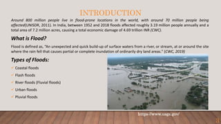
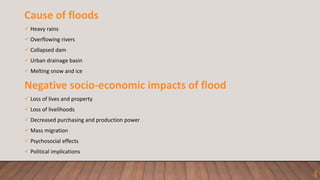
ES 694 SEMINAR PRESENTATION
A VISION FOR IMPROVING
FLOOD FORECASTING IN
INDIA
UNDER THE SUPERVISION OF:
PROFESSOR SUBHANKAR KARMAKAR
PRESENTED BY:
NITIN KUMAR
ROLL NO.: 213180005
ENVIRONMENTAL SCIENCE & ENGINEERING DEPARTMENT
INDIAN INSTITUTE OF TECHNOLOGY BOMBAY
NOVEMBER, 2021
1
ORGANISATION OF REPORT
➜ Introduction
 What is flood?
 Types and causes of flood
 Negative impacts of flood
➜ Flood forecasting
➜ Types of flood forecasting models
➜ Past efforts
➜ Case study
➜ Summary and Conclusion
2
INTRODUCTION
Around 800 million people live in flood-prone locations in the world, with around 70 million people being
affected(UNISDR, 2011). In India, between 1952 and 2018 floods affected roughly 3.19 million people annually and a
total area of 7.2 million acres, causing a total economic damage of 4.69 trillion INR (CWC).
What is Flood?
Flood is defined as, “An unexpected and quick build-up of surface waters from a river, or stream, at or around the site
where the rain fell that causes partial or complete inundation of ordinarily dry land areas." (CWC, 2019)
Types of Floods:
 Coastal floods
 Flash floods
 River floods (Fluvial floods)
 Urban floods
 Pluvial floods
https://www.usgs.gov/
3
Cause of floods
 Heavy rains
 Overflowing rivers
 Collapsed dam
 Urban drainage basin
 Melting snow and ice
Negative socio-economic impacts of flood
 Loss of lives and property
 Loss of livelihoods
 Decreased purchasing and production power
 Mass migration
 Psychosocial effects
 Political implications
4
FLOOD FORECASTING
Floods are challenging to regulate entirely because of the uncertainties (Todini et
al., 2005).
 Structures such as dams, embankments can reduce the risk but they cannot
eliminate it entirely. Furthermore the cost and implications of flood control
infrastructure are significant, that does not offer the desired degree of security and
is also vulnerable to failure without expensive maintenance.
Non-structural techniques are more flexible and less costly than structural methods
for reducing flood risk (Brooks et al., 2009).
5
TYPES OF FLOOD FORECASTING MODELS
Deterministic models
 Deterministic models solve a set of equations representing the different watershed processes that produce a
single model output for a given set of parameters.
 These models include components for the various hydrological and related processes, such as precipitation,
infiltration and soil moisture dynamics, evapotranspiration, runoff generation and streamflow routing.
 Precipitation is a critical input to these models and runoff and flow depth are the main outputs.
Data Driven Models
 Data-driven models provide the capability to simulate the random and probabilistic nature of inputs and
responses that govern river flows.
 These models depend upon the statistical or cause–effect relationships between hydrologic variables without
considering the physical processes that underlie the relationships.
 Data-driven models include stochastic models (e.g. Regression models, Time- Series models) and nonlinear time
series models (e.g. Artificial Neural Network models, Fuzzy Systems) that require extensive and high-quality
time series of hydrologic data.
6
Ensemble forecasts
 The concept of ensemble forecasting originated in the community to overcome the limitations associated
with the deterministic models.
 In ensemble prediction systems (EPS), a set of possible future states are provided through small changes in
the initial conditions, changes in parameterization schemes and solution schemes.
 In this rather than providing a single deterministic forecast, the EPS offers an ensemble prediction of
hydrological variables, such as streamflow or river level, that allow the identification of the most likely
scenario.
7
Hydrologic
Ensemble
Forecast Service
(HEFS) in the USA
European Flood
Awareness System
(EFAS)
EPS Models
PAST EFFORTS IN FLOOD FORECASTING
Case Study Models used Lead time
1. Chatterjee et al. (2010)
Mahanadi river basin,
. India
• Bootstrap-based artificial neural
networks (BANNs) are used to study the
uncertainty associated with hourly flood
forecasting.
• The Nash–Sutcliffe efficiency (E), root
mean square error (RMSE), mean
absolute error (MAE), and percentage
peak deviation (Pdv) are used to
evaluate the accuracy model.
1-10 hours
2. Roy et al. (2010)
Mahanadi basin, India
• To identify the peak and its related
travel time, both statistical methods and
ANN-based approaches are studied.
• K-mean and Fuzzy C-mean are used to
distinguish different peaks available for
the same travel time.
24 hour to 37 hour
8
3. Sharma et al. (2011)
Godavari Basin, India
• The Shuttled Radar Topographic Mission (SRTM)
Digital Elevation Model (DEM), and the soil
textural grid are used to calculate the topographic
and hydraulic parameters of each subbasin and
channel.
• HEC-HMS and HEC-Geo HMS are used as a
modelling environment for developing the flood
forecast model for the Godavari Basin.
12 hours
4. Naskar et al. (2012)
India
• WSNs (Wireless Sensor Networks) is used to
predict flood in rivers using simple and fast
calculations to provide real-time results.
• A weighted root mean square (wrms) method is
used for determining the accuracy of the system.
15 hours
5. Prakash et al. (2019)
Gandak River Basin, Bihar,
Inida
• This work tries to fill the gap by documenting the
different advanced methods used by local groups
in the Gandak River basin in Bihar, India, to
predict floods and heavy rainfall
• Many ecological signs were observed, with some
habitations claiming that rapid ant movement
signified either heavy rain or floods. In another,
a looming flood was signalled by the appearance
of tiny red ants travelling with their eggs in their
mouth or different types of sounds made by
toads.
*
9
CONCLUSION FROM LITERATURE SURVEY
• A Considerable amount of spatial and temporal data is required for these models to
give more accurate predictions. However, due to limited measurements and resource
constraints, researchers need to assume some of the data values that can affect the
accuracy of models. Most of the models, whose accuracy is low, is due to the fact that
they did not have accurate data for the Model to work. Even though India's scientific
community has made a lot of progress in terms of modelling, but the implementation
of the research is not done effectively.
10
CASE STUDY
Development of India's First Integrated Expert Urban Flood
Forecasting System for the City of Chennai (Ghosh et al., 2019)
• In 2015, Chennai was overwhelmed by heavy rains which affected over 4 million people and causing $3
million in losses. So, it was deemed essential to develop a flood forecasting system, as well as
management strategies in order to handle any future disasters of this nature.
• The combination of a tidal flood model, a stormwater drainage model, a regional weather forecast
model, an urban overland flow model, and a tide forecast model was used to design such a system.
• This newly designed system is maintained and implemented in Chennai Flood Warning System (C-
FLOWS) by NCCR (National Centre for Coastal Research).
• The developed expert flood forecasting system has six major components, which are connected to each
other and all the connections are automated through real-time forecast, monitoring and data sharing.
11
1.Regional Weather Forecasting Modelling
 The precipitation data was obtained from the National Centre for Medium Range Weather Forecasting
(NCMRWF) for a time period of 2007- 2017 to develop the regional framework.
 The forecasted data were characterized with uncertainty resulting from model bias both in spatial and
temporal directions, low hit rates, high false alarms etc.
 To improve the forecasts, a quantile regression based approach was used.
 Extreme rainfall events in 2015 and 2017 were used for validation of this model.
12
2. Tide and surge modelling
 The tide-surge simulations were carried out using ADvanced Circulation (ADCIRC) model, which
is a two-dimensional depth integrated (2DDI) shallow water equation model based on
hydrostatic pressure and Boussinesq approximation that solves the equation of motion
considering the effect of Coriolis force.
 It uses finite element method (FEM) for spatial discretization and finite difference method
(FDM) for temporal advancement
 The study was carried out considering 5 different tidal scenarios, as follows:
 Highest High Water Spring (HHWS)
 Highest High Water Neap (HHWN)
 Lowest Low Water Spring(LLWS)
 Lowest Low Water Neap (LLWN)
 Mean Tide
13
3. Monitoring of rainfall and flows using sensors
 Total 10 Automatic Weather Stations (AWSs) and five Automatic Rain gauges (ARGs) are used for observation
of weather across the Chennai river basin.
 All the stations are telemetry stations and automatically push the data to a central server for measuring the
water level in the rivers at different places across the basin.
 Six radar type water level recorders were installed across the basin.
 Further, a levelling survey was undertaken to establish the level of the sensor so that the measured water
level can be reported with reference to the mean sea level.
 This intensive observation campaign was done to measure the river discharges at different places with the
aim of developing the rating curve as well as to validate the developed hydrologic and hydraulic models.
14
 For validation, an extreme flood event that occurred in December 2015
was simulated, for which the observed flood depths from the survey
and sensor data were compared to the modelled flood depths .
 Around 80% of the validation points have an absolute difference of less
than a meter, and the majority of the places with absolute differences
of more than one meter (20%) were found around the river banks.
4. Upstream Hydrological Modelling
• HEC-HMS (Hydrological Engineering Center – Hydrologic Modelling System) is an event scale model
developed by the United States Army Corps of Engineers (USACE), is used for the hydrologic modelling of
upstream Chennai basin.
5. Urban Flood Modelling
 The hydrodynamic Model used for Chennai is MIKE FLOOD, which comprises of three components: MIKE11
for channel flow, MIKE 21 for tidal impacts and overland flow, and MIKE URBAN for urban specific
characteristics such as drainage.
 The hydrological Model and the tidal flood model provide inputs to the MIKE 11 model and the major river
cross-sections delineated using a high-resolution Light Detection and Ranging Digital Elevation Model (LiDAR
DEM), which are crucial input to the MIKE 21 model.
Error in Flood Inundation (Subimal Ghosh et al. 2019)
15
Integration and Implementation (Subimal Ghosh et al. 2019)
16
6. Integration, data bank generation and flood inundation
 A data bank was created containing 796 scenarios resulting from
rainfall extremes, with varied previous rainfall conditions, severity
levels of tide and return levels.
 As soon as the forecast is released, a search will take place in the look
up table developed based on the scenarios and the flood inundation
for the closest scenario will be provided as the initial forecasts.
 If both the 95th and 99th percentile inundation levels indicate a severe
flood, a real-time flood model will be launched using real-time
forecasted and observed data to keep the flood situation up to date.
SUMMARY AND CONCLUSIONS
 Although complete elimination of floods is not possible, specific measures can be taken to reduce the
damage caused by them like flood forecasting.
 In recent times most of the work related to flood forecasting in India is done using Artificial Neural
Network.
 Many flood forecasting models have been developed and implemented in various parts of India, but still,
there is a need for improvement in forecasting models to increase lead-time and accuracy of the forecast.
Some challenges that India need to overcome for developing an efficient flood forecasting model
 Lack of availability of data for flood forecasting,
 An efficient system for distribution and sharing of collected data,
 A low number of case studies for regional flood forecasts,
 Low computational power for doing complex calculations at a faster rate,
 Theft of sensors makes sensor-based forecast difficult
 Lead time of the forecast is less than the computational time of the Model.
17
Some of the future research areas which need improvement in order to overcome these challenges are:
 Flood inundation library to tackle the problem of low lead time,
 Developing of ensemble flood forecasting system,
 Improvement in collection and distribution of data,
 Effective flood warning system to ensure quick evacuation.
So, there is a dire need for India to make an efficient flood forecasting system capable of predicting floods with
sufficient lead time to protect lives, Otherwise India will continue to lose thousands of lives every year. India needs to
start investing more in pre-flood measures rather than post-flood operations.
18
ACKNOWLEDGEMENT
I would like to express my sincere gratitude to my guide, Prof. Subhankar Karmakar Sir
for his constant support, valuable guidance, and encouragement to carry out the
seminar work. I would also like to thank Prof. Shyam R. Asolekar Sir and Amritanshu
Shriwastav Sir for evaluating my work. At the last I would like to thank my parent
department – Environmental Science and Engineering Department for providing me the
opportunity for performing this study.
19
REFERENCES
• Acharya, A. and Prakash, A., 2019. When the river talks to its people: Local knowledge-based flood forecasting in Gandak River basin,
India. Environmental Development, 31, pp.55-67.
• Anil Kumar, K. and Anil Kumar, L., 2010. Development of flood forecasting system using statistical and ANN techniques in the downstream
catchment of Mahanadi Basin, India. Journal of Water Resource and Protection, 2010.
• Anupam, S. and Pani, P., 2020. Flood forecasting using a hybrid extreme learning machine-particle swarm optimization algorithm (ELM-
PSO) model. Modeling Earth Systems and Environment, 6(1), pp.341-347.
• Arduino, G., Reggiani, P. and Todini, E., 2005. Recent advances in flood forecasting and flood risk assessment. Hydrology and Earth System
Sciences, 9(4), pp.280-284.
• Biscarini, C., Francesco, S.D. and Manciola, P., 2010. CFD modelling approach for dam break flow studies. Hydrology and Earth System
Sciences, 14(4), pp.705-718.
• Brooks, D.B., Brandes, O.M., and Gurman, S., 2009. Making the most of the water we have: the soft path approach to water management.
• Cloke, H.L. and Pappenberger, F., 2009. Ensemble flood forecasting: A review. Journal of hydrology, 375(3-4), pp.613-626.
• Demeritt, D., Cloke, H., Pappenberger, F., Thielen, J., Bartholmes, J. and Ramos, M.H., 2007. Ensemble predictions and perceptions of risk,
uncertainty, and error in flood forecasting. Environmental Hazards, 7(2), pp.115-127.
• Ghosh, S. and Nayak, S., 2019. Development of India's first integrated expert urban flood forecasting system for Chennai. Current Science,
117(5), pp.741-745.
20
• Gogoi, S. and Chetia, B.C., 2011. Fuzzy rule-based flood forecasting model of Jiadhal River basin, Dhemaji, Assam, India. International Journal of
Fuzzy Mathematical Systems, 1, pp.59-71.
• Hardy, J., Gourley, J.J., Kain, J., Clark, A., Novak, D. and Hong, Y., 2013, December. Probabilistic Flash Flood Forecasting using Stormscale Ensembles.
In 94th American Meteorological Society Annual Meeting.
• Jain, S.K., Mani, P., Jain, S.K., Prakash, P., Singh, V.P., Tullos, D., Kumar, S., Agarwal, S.P. and Dimri, A.P., 2018. A Brief review of flood forecasting
techniques and their applications. International Journal of River Basin Management, 16(3), pp.329-344.
• Jonkman, S.N. and Kelman, I., 2005. An analysis of the causes and circumstances of flood disaster deaths. Disasters, 29(1), pp.75-97.
• Kar, A.K., Lohani, A.K., Goel, N.K. and Roy, G.P., 2017. Development of a fuzzy flood forecasting model for downstream of Hirakud Reservoir of
Mahanadi Basin, India. In River system analysis and management (pp. 211-218). Springer, Singapore.
• Srinithi, A., Sumathi, E., Sushmithawathi, K., Vaishnavi, M. and Muthukumaran, M., 2019. An Embedded Based Integrated Flood Forecasting
through HAM Communication. Asian Journal of Applied Science and Technology (AJAST) Volume, 3, pp.63-67.
• Tiwari, M.K. and Chatterjee, C., 2010. Uncertainty assessment and ensemble flood forecasting using bootstrap based artificial neural networks
(BANNs). Journal of Hydrology, 382(1-4), pp.20-33.
• Tullos, D., 2009. Assessing the influence of environmental impact assessments on science and policy: an analysis of the Three Gorges Project.
Journal of environmental management, 90, pp.S208-S223.
• WMO, 2011b. Manual on flood forecasting and warning, WMO No.1072. World Meteorological Organization, Geneva.
Book References
• Maidment, D.R., 1993. Handbook of hydrology (No. 631.587). McGraw-Hill.
21
KS!THAN
KS
22

213180005 Seminar presentation.pptx

  • 1.
    ES 694 SEMINARPRESENTATION A VISION FOR IMPROVING FLOOD FORECASTING IN INDIA UNDER THE SUPERVISION OF: PROFESSOR SUBHANKAR KARMAKAR PRESENTED BY: NITIN KUMAR ROLL NO.: 213180005 ENVIRONMENTAL SCIENCE & ENGINEERING DEPARTMENT INDIAN INSTITUTE OF TECHNOLOGY BOMBAY NOVEMBER, 2021 1
  • 2.
    ORGANISATION OF REPORT ➜Introduction  What is flood?  Types and causes of flood  Negative impacts of flood ➜ Flood forecasting ➜ Types of flood forecasting models ➜ Past efforts ➜ Case study ➜ Summary and Conclusion 2
  • 3.
    INTRODUCTION Around 800 millionpeople live in flood-prone locations in the world, with around 70 million people being affected(UNISDR, 2011). In India, between 1952 and 2018 floods affected roughly 3.19 million people annually and a total area of 7.2 million acres, causing a total economic damage of 4.69 trillion INR (CWC). What is Flood? Flood is defined as, “An unexpected and quick build-up of surface waters from a river, or stream, at or around the site where the rain fell that causes partial or complete inundation of ordinarily dry land areas." (CWC, 2019) Types of Floods:  Coastal floods  Flash floods  River floods (Fluvial floods)  Urban floods  Pluvial floods https://www.usgs.gov/ 3
  • 4.
    Cause of floods Heavy rains  Overflowing rivers  Collapsed dam  Urban drainage basin  Melting snow and ice Negative socio-economic impacts of flood  Loss of lives and property  Loss of livelihoods  Decreased purchasing and production power  Mass migration  Psychosocial effects  Political implications 4
  • 5.
    FLOOD FORECASTING Floods arechallenging to regulate entirely because of the uncertainties (Todini et al., 2005).  Structures such as dams, embankments can reduce the risk but they cannot eliminate it entirely. Furthermore the cost and implications of flood control infrastructure are significant, that does not offer the desired degree of security and is also vulnerable to failure without expensive maintenance. Non-structural techniques are more flexible and less costly than structural methods for reducing flood risk (Brooks et al., 2009). 5
  • 6.
    TYPES OF FLOODFORECASTING MODELS Deterministic models  Deterministic models solve a set of equations representing the different watershed processes that produce a single model output for a given set of parameters.  These models include components for the various hydrological and related processes, such as precipitation, infiltration and soil moisture dynamics, evapotranspiration, runoff generation and streamflow routing.  Precipitation is a critical input to these models and runoff and flow depth are the main outputs. Data Driven Models  Data-driven models provide the capability to simulate the random and probabilistic nature of inputs and responses that govern river flows.  These models depend upon the statistical or cause–effect relationships between hydrologic variables without considering the physical processes that underlie the relationships.  Data-driven models include stochastic models (e.g. Regression models, Time- Series models) and nonlinear time series models (e.g. Artificial Neural Network models, Fuzzy Systems) that require extensive and high-quality time series of hydrologic data. 6
  • 7.
    Ensemble forecasts  Theconcept of ensemble forecasting originated in the community to overcome the limitations associated with the deterministic models.  In ensemble prediction systems (EPS), a set of possible future states are provided through small changes in the initial conditions, changes in parameterization schemes and solution schemes.  In this rather than providing a single deterministic forecast, the EPS offers an ensemble prediction of hydrological variables, such as streamflow or river level, that allow the identification of the most likely scenario. 7 Hydrologic Ensemble Forecast Service (HEFS) in the USA European Flood Awareness System (EFAS) EPS Models
  • 8.
    PAST EFFORTS INFLOOD FORECASTING Case Study Models used Lead time 1. Chatterjee et al. (2010) Mahanadi river basin, . India • Bootstrap-based artificial neural networks (BANNs) are used to study the uncertainty associated with hourly flood forecasting. • The Nash–Sutcliffe efficiency (E), root mean square error (RMSE), mean absolute error (MAE), and percentage peak deviation (Pdv) are used to evaluate the accuracy model. 1-10 hours 2. Roy et al. (2010) Mahanadi basin, India • To identify the peak and its related travel time, both statistical methods and ANN-based approaches are studied. • K-mean and Fuzzy C-mean are used to distinguish different peaks available for the same travel time. 24 hour to 37 hour 8
  • 9.
    3. Sharma etal. (2011) Godavari Basin, India • The Shuttled Radar Topographic Mission (SRTM) Digital Elevation Model (DEM), and the soil textural grid are used to calculate the topographic and hydraulic parameters of each subbasin and channel. • HEC-HMS and HEC-Geo HMS are used as a modelling environment for developing the flood forecast model for the Godavari Basin. 12 hours 4. Naskar et al. (2012) India • WSNs (Wireless Sensor Networks) is used to predict flood in rivers using simple and fast calculations to provide real-time results. • A weighted root mean square (wrms) method is used for determining the accuracy of the system. 15 hours 5. Prakash et al. (2019) Gandak River Basin, Bihar, Inida • This work tries to fill the gap by documenting the different advanced methods used by local groups in the Gandak River basin in Bihar, India, to predict floods and heavy rainfall • Many ecological signs were observed, with some habitations claiming that rapid ant movement signified either heavy rain or floods. In another, a looming flood was signalled by the appearance of tiny red ants travelling with their eggs in their mouth or different types of sounds made by toads. * 9
  • 10.
    CONCLUSION FROM LITERATURESURVEY • A Considerable amount of spatial and temporal data is required for these models to give more accurate predictions. However, due to limited measurements and resource constraints, researchers need to assume some of the data values that can affect the accuracy of models. Most of the models, whose accuracy is low, is due to the fact that they did not have accurate data for the Model to work. Even though India's scientific community has made a lot of progress in terms of modelling, but the implementation of the research is not done effectively. 10
  • 11.
    CASE STUDY Development ofIndia's First Integrated Expert Urban Flood Forecasting System for the City of Chennai (Ghosh et al., 2019) • In 2015, Chennai was overwhelmed by heavy rains which affected over 4 million people and causing $3 million in losses. So, it was deemed essential to develop a flood forecasting system, as well as management strategies in order to handle any future disasters of this nature. • The combination of a tidal flood model, a stormwater drainage model, a regional weather forecast model, an urban overland flow model, and a tide forecast model was used to design such a system. • This newly designed system is maintained and implemented in Chennai Flood Warning System (C- FLOWS) by NCCR (National Centre for Coastal Research). • The developed expert flood forecasting system has six major components, which are connected to each other and all the connections are automated through real-time forecast, monitoring and data sharing. 11
  • 12.
    1.Regional Weather ForecastingModelling  The precipitation data was obtained from the National Centre for Medium Range Weather Forecasting (NCMRWF) for a time period of 2007- 2017 to develop the regional framework.  The forecasted data were characterized with uncertainty resulting from model bias both in spatial and temporal directions, low hit rates, high false alarms etc.  To improve the forecasts, a quantile regression based approach was used.  Extreme rainfall events in 2015 and 2017 were used for validation of this model. 12
  • 13.
    2. Tide andsurge modelling  The tide-surge simulations were carried out using ADvanced Circulation (ADCIRC) model, which is a two-dimensional depth integrated (2DDI) shallow water equation model based on hydrostatic pressure and Boussinesq approximation that solves the equation of motion considering the effect of Coriolis force.  It uses finite element method (FEM) for spatial discretization and finite difference method (FDM) for temporal advancement  The study was carried out considering 5 different tidal scenarios, as follows:  Highest High Water Spring (HHWS)  Highest High Water Neap (HHWN)  Lowest Low Water Spring(LLWS)  Lowest Low Water Neap (LLWN)  Mean Tide 13
  • 14.
    3. Monitoring ofrainfall and flows using sensors  Total 10 Automatic Weather Stations (AWSs) and five Automatic Rain gauges (ARGs) are used for observation of weather across the Chennai river basin.  All the stations are telemetry stations and automatically push the data to a central server for measuring the water level in the rivers at different places across the basin.  Six radar type water level recorders were installed across the basin.  Further, a levelling survey was undertaken to establish the level of the sensor so that the measured water level can be reported with reference to the mean sea level.  This intensive observation campaign was done to measure the river discharges at different places with the aim of developing the rating curve as well as to validate the developed hydrologic and hydraulic models. 14
  • 15.
     For validation,an extreme flood event that occurred in December 2015 was simulated, for which the observed flood depths from the survey and sensor data were compared to the modelled flood depths .  Around 80% of the validation points have an absolute difference of less than a meter, and the majority of the places with absolute differences of more than one meter (20%) were found around the river banks. 4. Upstream Hydrological Modelling • HEC-HMS (Hydrological Engineering Center – Hydrologic Modelling System) is an event scale model developed by the United States Army Corps of Engineers (USACE), is used for the hydrologic modelling of upstream Chennai basin. 5. Urban Flood Modelling  The hydrodynamic Model used for Chennai is MIKE FLOOD, which comprises of three components: MIKE11 for channel flow, MIKE 21 for tidal impacts and overland flow, and MIKE URBAN for urban specific characteristics such as drainage.  The hydrological Model and the tidal flood model provide inputs to the MIKE 11 model and the major river cross-sections delineated using a high-resolution Light Detection and Ranging Digital Elevation Model (LiDAR DEM), which are crucial input to the MIKE 21 model. Error in Flood Inundation (Subimal Ghosh et al. 2019) 15
  • 16.
    Integration and Implementation(Subimal Ghosh et al. 2019) 16 6. Integration, data bank generation and flood inundation  A data bank was created containing 796 scenarios resulting from rainfall extremes, with varied previous rainfall conditions, severity levels of tide and return levels.  As soon as the forecast is released, a search will take place in the look up table developed based on the scenarios and the flood inundation for the closest scenario will be provided as the initial forecasts.  If both the 95th and 99th percentile inundation levels indicate a severe flood, a real-time flood model will be launched using real-time forecasted and observed data to keep the flood situation up to date.
  • 17.
    SUMMARY AND CONCLUSIONS Although complete elimination of floods is not possible, specific measures can be taken to reduce the damage caused by them like flood forecasting.  In recent times most of the work related to flood forecasting in India is done using Artificial Neural Network.  Many flood forecasting models have been developed and implemented in various parts of India, but still, there is a need for improvement in forecasting models to increase lead-time and accuracy of the forecast. Some challenges that India need to overcome for developing an efficient flood forecasting model  Lack of availability of data for flood forecasting,  An efficient system for distribution and sharing of collected data,  A low number of case studies for regional flood forecasts,  Low computational power for doing complex calculations at a faster rate,  Theft of sensors makes sensor-based forecast difficult  Lead time of the forecast is less than the computational time of the Model. 17
  • 18.
    Some of thefuture research areas which need improvement in order to overcome these challenges are:  Flood inundation library to tackle the problem of low lead time,  Developing of ensemble flood forecasting system,  Improvement in collection and distribution of data,  Effective flood warning system to ensure quick evacuation. So, there is a dire need for India to make an efficient flood forecasting system capable of predicting floods with sufficient lead time to protect lives, Otherwise India will continue to lose thousands of lives every year. India needs to start investing more in pre-flood measures rather than post-flood operations. 18
  • 19.
    ACKNOWLEDGEMENT I would liketo express my sincere gratitude to my guide, Prof. Subhankar Karmakar Sir for his constant support, valuable guidance, and encouragement to carry out the seminar work. I would also like to thank Prof. Shyam R. Asolekar Sir and Amritanshu Shriwastav Sir for evaluating my work. At the last I would like to thank my parent department – Environmental Science and Engineering Department for providing me the opportunity for performing this study. 19
  • 20.
    REFERENCES • Acharya, A.and Prakash, A., 2019. When the river talks to its people: Local knowledge-based flood forecasting in Gandak River basin, India. Environmental Development, 31, pp.55-67. • Anil Kumar, K. and Anil Kumar, L., 2010. Development of flood forecasting system using statistical and ANN techniques in the downstream catchment of Mahanadi Basin, India. Journal of Water Resource and Protection, 2010. • Anupam, S. and Pani, P., 2020. Flood forecasting using a hybrid extreme learning machine-particle swarm optimization algorithm (ELM- PSO) model. Modeling Earth Systems and Environment, 6(1), pp.341-347. • Arduino, G., Reggiani, P. and Todini, E., 2005. Recent advances in flood forecasting and flood risk assessment. Hydrology and Earth System Sciences, 9(4), pp.280-284. • Biscarini, C., Francesco, S.D. and Manciola, P., 2010. CFD modelling approach for dam break flow studies. Hydrology and Earth System Sciences, 14(4), pp.705-718. • Brooks, D.B., Brandes, O.M., and Gurman, S., 2009. Making the most of the water we have: the soft path approach to water management. • Cloke, H.L. and Pappenberger, F., 2009. Ensemble flood forecasting: A review. Journal of hydrology, 375(3-4), pp.613-626. • Demeritt, D., Cloke, H., Pappenberger, F., Thielen, J., Bartholmes, J. and Ramos, M.H., 2007. Ensemble predictions and perceptions of risk, uncertainty, and error in flood forecasting. Environmental Hazards, 7(2), pp.115-127. • Ghosh, S. and Nayak, S., 2019. Development of India's first integrated expert urban flood forecasting system for Chennai. Current Science, 117(5), pp.741-745. 20
  • 21.
    • Gogoi, S.and Chetia, B.C., 2011. Fuzzy rule-based flood forecasting model of Jiadhal River basin, Dhemaji, Assam, India. International Journal of Fuzzy Mathematical Systems, 1, pp.59-71. • Hardy, J., Gourley, J.J., Kain, J., Clark, A., Novak, D. and Hong, Y., 2013, December. Probabilistic Flash Flood Forecasting using Stormscale Ensembles. In 94th American Meteorological Society Annual Meeting. • Jain, S.K., Mani, P., Jain, S.K., Prakash, P., Singh, V.P., Tullos, D., Kumar, S., Agarwal, S.P. and Dimri, A.P., 2018. A Brief review of flood forecasting techniques and their applications. International Journal of River Basin Management, 16(3), pp.329-344. • Jonkman, S.N. and Kelman, I., 2005. An analysis of the causes and circumstances of flood disaster deaths. Disasters, 29(1), pp.75-97. • Kar, A.K., Lohani, A.K., Goel, N.K. and Roy, G.P., 2017. Development of a fuzzy flood forecasting model for downstream of Hirakud Reservoir of Mahanadi Basin, India. In River system analysis and management (pp. 211-218). Springer, Singapore. • Srinithi, A., Sumathi, E., Sushmithawathi, K., Vaishnavi, M. and Muthukumaran, M., 2019. An Embedded Based Integrated Flood Forecasting through HAM Communication. Asian Journal of Applied Science and Technology (AJAST) Volume, 3, pp.63-67. • Tiwari, M.K. and Chatterjee, C., 2010. Uncertainty assessment and ensemble flood forecasting using bootstrap based artificial neural networks (BANNs). Journal of Hydrology, 382(1-4), pp.20-33. • Tullos, D., 2009. Assessing the influence of environmental impact assessments on science and policy: an analysis of the Three Gorges Project. Journal of environmental management, 90, pp.S208-S223. • WMO, 2011b. Manual on flood forecasting and warning, WMO No.1072. World Meteorological Organization, Geneva. Book References • Maidment, D.R., 1993. Handbook of hydrology (No. 631.587). McGraw-Hill. 21
  • 22.

Editor's Notes