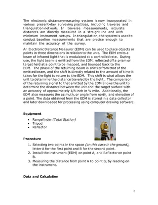
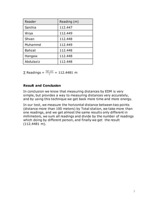
1. The document discusses electronic distance measurement (EDM) using a total station to measure distances between two points. An EDM emits a beam of light to a target prism and back to calculate the distance based on the phase shift of the returning beam.
2. Equipment used includes a total station, tripod, and reflector. The procedure involves setting up the total station on point A and placing the reflector on point B to take distance measurements.
3. Multiple readings were taken between two points over 100 meters apart by different people. Taking the sum of readings and dividing by the number of readings yielded a result of 112.4481 meters, demonstrating EDM's high accuracy for distance measurement.
Report Assignment 2 for Site Surveying module which requires us to do Traversing measurement around the campus carpark, for the Bachelor of Quantity Surveying (BQS) Course Semester 2, Taylor's University Lakeside Campus
unit I
Introduction and Basic Concepts: Introduction, Objectives, classification and principles of
surveying, Scales, Shrinkage of Map, Conventional symbols and Code of Signals, Surveying
accessories, phases of surveying.
Measurement of Distances and Directions
Linear distances- Approximate methods, Direct Methods- Chains- Tapes, ranging, Tape corrections.
Prismatic Compass- Bearings, included angles, Local Attraction, Magnetic Declination and dip.
In this lecture we will cover
Applications of levelling
Equipment and procedures
Purposes of levelling
Some definitions
Applications
Longitudinal sections and cross sections
Plotting the profile
Procedure of profile
Procedure of cross-section:
Plotting the cross-section:
Prepared by:
Asst. Prof. Salar K.Hussein
Mr. Kamal Y.Abdullah
Asst.Lecturer. Dilveen H. Omar
Erbil Polytechnic University
Technical Engineering College
Civil Engineering Department
Edm is a surveying instrument used to measure the distance electronically. This Surveying Instrument is used in triangulation to measure the length of Base line because more accuracy is required to measure the length of base line.
The Global Positioning System is a satellite-based radio navigation system for determination of precise position and time, using radio signals from the satellites, in real-time or in post-processing mode.
Metric Chain : It Consists of galvanized mild steel wire of 4mm diameter known as link.
It is available in 20m, 30m, 50m length which consists of 100 links.
Gunter’s Chain : A 66 feet long chain consists of 100 links, each of 0.66 feet, it is known as Gunter’s chain.
This chain is suitable for taking length in miles.
Engineer’s Chain : A 100 feet long chain consisting of 100 links each of 1 feet is known as engineer’s chain.
This chain is used to measure length in feet and area in sq.yard.
Revenue Chain : it is 33 feet long chain consisting of 16 links.
This chain is used for distance measurements in feet & inches for smaller areas.
Information regarding cadastral mapping and various survey techniques.
Well touch to technical student regarding the cadastral mapping its benefits to their career.
Introduction, electromagnetic spectrum, electromagnetic distance measurement, types of EDM instruments, electronic digital theodolites, total station, digital levels, scanners for topographical survey, global positioning system.
EDM-Electronic Distance Measurement by Denis Jangeed.pptxDenish Jangid
EDM-Electronic Distance Measurement by Denis Jangeed
Origin of Electronic Distance Measurement
Principle of E.D.M. (Electronic Distance Measurements), Modulation,
Types of E.D.M., Distomat,
advantages and application.
electromagnetic waves
EDM Range 100 KM
EDM accuracy of 1 in 105
Electromagnetic Spectrum Range
microwaves, infrared waves and visible light waves
Measurement of distance with EDM and a Reflector
Classification of Electronic Distance Measurement Instrument
EDM instruments are classified based on the type of carrier wave as
Microwave instruments
Infrared wave instruments
Light wave instruments.
Parts of EDM instruments
Geodimeter
Tellurometer
Distomat
Errors in EDM
EDM & GPS Surveys. Topographical, elevation and building surveys We Measure – What?
Linear
Angular
Modern Equipments
Requirements
Accuracy
Functionality
Integration
Productivity
Ease of Use
Due to the increasing number of private cars in today's society, there are a lot of
safety problems in car reversing. This paper proposes a research program of ultrasonic
ranging car reversing radar system with higher accuracy and better warning effect. According
to the principle of ultrasonic ranging, the AT89C51 single-chip microcomputer is selected as
the core circuit, and the anti-interference error processing is adopted in the processing of the
single-chip microcomputer to solve the multiple measurement, the transmission time interval
and the dead zone measurement problem of the ultrasonic ranging. Car reversing radar
system based on ultrasonic ranging adopt transmitting and receiving circuit, will determine
the time difference in the single chip microcomputer. the results are sent to the digital display
circuit and voice broadcast circuit. Finally, it is verified by experiments that after ultrasonic
error measurement adopts error processing, under the complicated environmental conditions,
the accuracy of ranging is higher, the number of false alarms is reduced, and the device has
high reliability and practicability.
Similar to Electronic Distance Measurement (EDM) - Report (20)
Specific gravity is the ratio of the density of a substance to the density of a reference substance; equivalently, it is the ratio of the mass of a substance to the mass of a reference substance for the same given volume.
By: Sarchia Khursheed
Industrial Training at Shahjalal Fertilizer Company Limited (SFCL)MdTanvirMahtab2
This presentation is about the working procedure of Shahjalal Fertilizer Company Limited (SFCL). A Govt. owned Company of Bangladesh Chemical Industries Corporation under Ministry of Industries.
Hybrid optimization of pumped hydro system and solar- Engr. Abdul-Azeez.pdffxintegritypublishin
Advancements in technology unveil a myriad of electrical and electronic breakthroughs geared towards efficiently harnessing limited resources to meet human energy demands. The optimization of hybrid solar PV panels and pumped hydro energy supply systems plays a pivotal role in utilizing natural resources effectively. This initiative not only benefits humanity but also fosters environmental sustainability. The study investigated the design optimization of these hybrid systems, focusing on understanding solar radiation patterns, identifying geographical influences on solar radiation, formulating a mathematical model for system optimization, and determining the optimal configuration of PV panels and pumped hydro storage. Through a comparative analysis approach and eight weeks of data collection, the study addressed key research questions related to solar radiation patterns and optimal system design. The findings highlighted regions with heightened solar radiation levels, showcasing substantial potential for power generation and emphasizing the system's efficiency. Optimizing system design significantly boosted power generation, promoted renewable energy utilization, and enhanced energy storage capacity. The study underscored the benefits of optimizing hybrid solar PV panels and pumped hydro energy supply systems for sustainable energy usage. Optimizing the design of solar PV panels and pumped hydro energy supply systems as examined across diverse climatic conditions in a developing country, not only enhances power generation but also improves the integration of renewable energy sources and boosts energy storage capacities, particularly beneficial for less economically prosperous regions. Additionally, the study provides valuable insights for advancing energy research in economically viable areas. Recommendations included conducting site-specific assessments, utilizing advanced modeling tools, implementing regular maintenance protocols, and enhancing communication among system components.
NO1 Uk best vashikaran specialist in delhi vashikaran baba near me online vas...Amil Baba Dawood bangali
Contact with Dawood Bhai Just call on +92322-6382012 and we'll help you. We'll solve all your problems within 12 to 24 hours and with 101% guarantee and with astrology systematic. If you want to take any personal or professional advice then also you can call us on +92322-6382012 , ONLINE LOVE PROBLEM & Other all types of Daily Life Problem's.Then CALL or WHATSAPP us on +92322-6382012 and Get all these problems solutions here by Amil Baba DAWOOD BANGALI
#vashikaranspecialist #astrologer #palmistry #amliyaat #taweez #manpasandshadi #horoscope #spiritual #lovelife #lovespell #marriagespell#aamilbabainpakistan #amilbabainkarachi #powerfullblackmagicspell #kalajadumantarspecialist #realamilbaba #AmilbabainPakistan #astrologerincanada #astrologerindubai #lovespellsmaster #kalajaduspecialist #lovespellsthatwork #aamilbabainlahore#blackmagicformarriage #aamilbaba #kalajadu #kalailam #taweez #wazifaexpert #jadumantar #vashikaranspecialist #astrologer #palmistry #amliyaat #taweez #manpasandshadi #horoscope #spiritual #lovelife #lovespell #marriagespell#aamilbabainpakistan #amilbabainkarachi #powerfullblackmagicspell #kalajadumantarspecialist #realamilbaba #AmilbabainPakistan #astrologerincanada #astrologerindubai #lovespellsmaster #kalajaduspecialist #lovespellsthatwork #aamilbabainlahore #blackmagicforlove #blackmagicformarriage #aamilbaba #kalajadu #kalailam #taweez #wazifaexpert #jadumantar #vashikaranspecialist #astrologer #palmistry #amliyaat #taweez #manpasandshadi #horoscope #spiritual #lovelife #lovespell #marriagespell#aamilbabainpakistan #amilbabainkarachi #powerfullblackmagicspell #kalajadumantarspecialist #realamilbaba #AmilbabainPakistan #astrologerincanada #astrologerindubai #lovespellsmaster #kalajaduspecialist #lovespellsthatwork #aamilbabainlahore #Amilbabainuk #amilbabainspain #amilbabaindubai #Amilbabainnorway #amilbabainkrachi #amilbabainlahore #amilbabaingujranwalan #amilbabainislamabad
Saudi Arabia stands as a titan in the global energy landscape, renowned for its abundant oil and gas resources. It's the largest exporter of petroleum and holds some of the world's most significant reserves. Let's delve into the top 10 oil and gas projects shaping Saudi Arabia's energy future in 2024.
Immunizing Image Classifiers Against Localized Adversary Attacksgerogepatton
This paper addresses the vulnerability of deep learning models, particularly convolutional neural networks
(CNN)s, to adversarial attacks and presents a proactive training technique designed to counter them. We
introduce a novel volumization algorithm, which transforms 2D images into 3D volumetric representations.
When combined with 3D convolution and deep curriculum learning optimization (CLO), itsignificantly improves
the immunity of models against localized universal attacks by up to 40%. We evaluate our proposed approach
using contemporary CNN architectures and the modified Canadian Institute for Advanced Research (CIFAR-10
and CIFAR-100) and ImageNet Large Scale Visual Recognition Challenge (ILSVRC12) datasets, showcasing
accuracy improvements over previous techniques. The results indicate that the combination of the volumetric
input and curriculum learning holds significant promise for mitigating adversarial attacks without necessitating
adversary training.
Welcome to WIPAC Monthly the magazine brought to you by the LinkedIn Group Water Industry Process Automation & Control.
In this month's edition, along with this month's industry news to celebrate the 13 years since the group was created we have articles including
A case study of the used of Advanced Process Control at the Wastewater Treatment works at Lleida in Spain
A look back on an article on smart wastewater networks in order to see how the industry has measured up in the interim around the adoption of Digital Transformation in the Water Industry.
Gen AI Study Jams _ For the GDSC Leads in India.pdf
Electronic Distance Measurement (EDM) - Report
1. 1
Soran University
Faculty of Engineering - Civil Engineering Department
Electronic Distance
Measurement
Student: Sarchia Khursheed
Group: 2nd
Date: 29.3.2016
Supervisor: Eng. Anwar Jabbar
Introduction
2. 2
The electronic distance-measuring system is now incorporated in
various present-day surveying practices, including traverse and
triangulation network. In traverse measurements, accurate
distances are directly measured in a straight line and with
minimum instrument setups. In triangulation, the system is used to
conduct baseline measurements that are precise enough to
maintain the accuracy of the survey.
An Electronic Distance Measurer (EDM) can be used to place objects or
points in three dimensions in relation to the unit. The EDM emits a
beam of infrared light that is modulated at a controlled rate. During
use, the light beam is emitted from the EDM, reflected off a prism or
target held at a point to be mapped, and bounced back to the
EDM. The phase of the returning beam is shifted from that of the
emitted beam, and the shift is directly related to the amount of time it
takes for the light to return to the EDM. This shift is what allows the
unit to determine the distance traveled by the light. The comparison
of the returning signal to that emitted by the EDM allows the unit to
determine the distance between the unit and the target surface with
an accuracy of approximately 1/8 inch in ¼ mile. Additionally, the
EDM also measures the azimuth, or angle from north, and elevation of
a point. The data obtained from the EDM is stored in a data collector
and later downloaded for processing using computer drawing software.
Equipment
Rangefinder (Total Station)
Tripod
Reflector
Procedure
1. Selecting two points in the space (on this case in the ground),
letter A for the first point and B for the second point.
2. Install the instrument (EDM) on point A, and Reflector on point
B.
3. Measuring the distance from point A to point B, by reading on
the instrument.
Data and Calculation
3. 3
Reader Reading (m)
Sarchia 112.447
Wrya 112.449
Shvan 112.448
Muhammd 112.449
Bahzat 112.448
Hangaw 112.448
Abdulaziz 112.448
∑ Readings =
787.137
7
= 112.4481 m
Result and Conclusion
In conclusion we know that measuring distances by EDM is very
simple, but provides a way to measuring distances very accurately,
and by using this technique we get back more time and more energy.
In our test, we measure the horizontal distance between two points
(distance more than 100 meters) by Total station, we take more than
one readings, and we get almost the same results only different in
millimeters, we sum all readings and divide by the number of readings
which doing by different person, and finally we get the result
(112.4481 m).