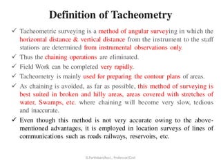
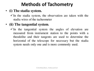
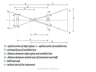
The document discusses tacheometric surveying, which is a method of angular surveying that determines horizontal and vertical distances from instrumental observations alone, eliminating chaining operations. It is well-suited for hilly, broken, or inaccessible areas. The key principles are described, including the use of a tacheometer instrument fitted with stadia wires, and a stadia rod. The two main methods - fixed hair and movable hair - are outlined. Errors and precautions for tacheometric surveying are also provided.
Introduction, purpose, principle, instruments, methods of tacheometry, stadia constants, anallatic lens, Subtense bar, field work in tacheometry, reduction of readings, errors and precisions.
Surveying is an important part of Civil engineering. Various part like theodolite, plane table surveying, computation of area and volume are useful for all university examination and other competitive examination
Introduction to surveying, ranging and chainingShital Navghare
This presentation contains the complete introduction of surveying. It also includes all the instrucments used in linear measurement and the terms related to Ranging and Chaining
Introduction, electromagnetic spectrum, electromagnetic distance measurement, types of EDM instruments, electronic digital theodolites, total station, digital levels, scanners for topographical survey, global positioning system.
Metric Chain : It Consists of galvanized mild steel wire of 4mm diameter known as link.
It is available in 20m, 30m, 50m length which consists of 100 links.
Gunter’s Chain : A 66 feet long chain consists of 100 links, each of 0.66 feet, it is known as Gunter’s chain.
This chain is suitable for taking length in miles.
Engineer’s Chain : A 100 feet long chain consisting of 100 links each of 1 feet is known as engineer’s chain.
This chain is used to measure length in feet and area in sq.yard.
Revenue Chain : it is 33 feet long chain consisting of 16 links.
This chain is used for distance measurements in feet & inches for smaller areas.
Surveying Engineering
Traversing Practical part 1
Plane and Applied surveying 2
Report number(2)
• Report name :Gales Traverse Table(Horizontal angle
measurement (FL)of closed traversing
• Apparatus
• Theodolite Instrument
• Tripod
• Compass
• Pin
• Tape
• Range pole
Object
• To conducted survey work in a closed traversing and calculate
in depend coordinates and area calculation by coordinate rule.
Procedure Traverse;
Calculations Traverse .Dada Sheet and Table method work clock wise surveying
-Gales Traverse Table.
*Traverse Calculations
-Traverse Calculation.
-Coordinate conversions.
-Signs of Departures and Latitudes.
*Balancing latitude and departure
-Correction for ∆E& ∆N:
Bowditch adjustment or compass method
-The example…
-Vector components (pre-adjustment)
*The adjustment components
Prepared by:
Asst. Prof. Salar K.Hussein
Mr. Kamal Y.Abdullah
Asst.Lecturer. Dilveen H. Omar
Erbil Polytechnic University
Technical Engineering College
Civil Engineering Department
Surveying is an important part of Civil engineering. Various part like theodolite, plane table surveying, computation of area and volume are useful for all university examination and other competitive examination
unit I
Introduction and Basic Concepts: Introduction, Objectives, classification and principles of
surveying, Scales, Shrinkage of Map, Conventional symbols and Code of Signals, Surveying
accessories, phases of surveying.
Measurement of Distances and Directions
Linear distances- Approximate methods, Direct Methods- Chains- Tapes, ranging, Tape corrections.
Prismatic Compass- Bearings, included angles, Local Attraction, Magnetic Declination and dip.
Hierarchical Digital Twin of a Naval Power SystemKerry Sado
A hierarchical digital twin of a Naval DC power system has been developed and experimentally verified. Similar to other state-of-the-art digital twins, this technology creates a digital replica of the physical system executed in real-time or faster, which can modify hardware controls. However, its advantage stems from distributing computational efforts by utilizing a hierarchical structure composed of lower-level digital twin blocks and a higher-level system digital twin. Each digital twin block is associated with a physical subsystem of the hardware and communicates with a singular system digital twin, which creates a system-level response. By extracting information from each level of the hierarchy, power system controls of the hardware were reconfigured autonomously. This hierarchical digital twin development offers several advantages over other digital twins, particularly in the field of naval power systems. The hierarchical structure allows for greater computational efficiency and scalability while the ability to autonomously reconfigure hardware controls offers increased flexibility and responsiveness. The hierarchical decomposition and models utilized were well aligned with the physical twin, as indicated by the maximum deviations between the developed digital twin hierarchy and the hardware.
Industrial Training at Shahjalal Fertilizer Company Limited (SFCL)MdTanvirMahtab2
This presentation is about the working procedure of Shahjalal Fertilizer Company Limited (SFCL). A Govt. owned Company of Bangladesh Chemical Industries Corporation under Ministry of Industries.
About
Indigenized remote control interface card suitable for MAFI system CCR equipment. Compatible for IDM8000 CCR. Backplane mounted serial and TCP/Ethernet communication module for CCR remote access. IDM 8000 CCR remote control on serial and TCP protocol.
• Remote control: Parallel or serial interface.
• Compatible with MAFI CCR system.
• Compatible with IDM8000 CCR.
• Compatible with Backplane mount serial communication.
• Compatible with commercial and Defence aviation CCR system.
• Remote control system for accessing CCR and allied system over serial or TCP.
• Indigenized local Support/presence in India.
• Easy in configuration using DIP switches.
Technical Specifications
Indigenized remote control interface card suitable for MAFI system CCR equipment. Compatible for IDM8000 CCR. Backplane mounted serial and TCP/Ethernet communication module for CCR remote access. IDM 8000 CCR remote control on serial and TCP protocol.
Key Features
Indigenized remote control interface card suitable for MAFI system CCR equipment. Compatible for IDM8000 CCR. Backplane mounted serial and TCP/Ethernet communication module for CCR remote access. IDM 8000 CCR remote control on serial and TCP protocol.
• Remote control: Parallel or serial interface
• Compatible with MAFI CCR system
• Copatiable with IDM8000 CCR
• Compatible with Backplane mount serial communication.
• Compatible with commercial and Defence aviation CCR system.
• Remote control system for accessing CCR and allied system over serial or TCP.
• Indigenized local Support/presence in India.
Application
• Remote control: Parallel or serial interface.
• Compatible with MAFI CCR system.
• Compatible with IDM8000 CCR.
• Compatible with Backplane mount serial communication.
• Compatible with commercial and Defence aviation CCR system.
• Remote control system for accessing CCR and allied system over serial or TCP.
• Indigenized local Support/presence in India.
• Easy in configuration using DIP switches.
Welcome to WIPAC Monthly the magazine brought to you by the LinkedIn Group Water Industry Process Automation & Control.
In this month's edition, along with this month's industry news to celebrate the 13 years since the group was created we have articles including
A case study of the used of Advanced Process Control at the Wastewater Treatment works at Lleida in Spain
A look back on an article on smart wastewater networks in order to see how the industry has measured up in the interim around the adoption of Digital Transformation in the Water Industry.
Cosmetic shop management system project report.pdfKamal Acharya
Buying new cosmetic products is difficult. It can even be scary for those who have sensitive skin and are prone to skin trouble. The information needed to alleviate this problem is on the back of each product, but it's thought to interpret those ingredient lists unless you have a background in chemistry.
Instead of buying and hoping for the best, we can use data science to help us predict which products may be good fits for us. It includes various function programs to do the above mentioned tasks.
Data file handling has been effectively used in the program.
The automated cosmetic shop management system should deal with the automation of general workflow and administration process of the shop. The main processes of the system focus on customer's request where the system is able to search the most appropriate products and deliver it to the customers. It should help the employees to quickly identify the list of cosmetic product that have reached the minimum quantity and also keep a track of expired date for each cosmetic product. It should help the employees to find the rack number in which the product is placed.It is also Faster and more efficient way.
Saudi Arabia stands as a titan in the global energy landscape, renowned for its abundant oil and gas resources. It's the largest exporter of petroleum and holds some of the world's most significant reserves. Let's delve into the top 10 oil and gas projects shaping Saudi Arabia's energy future in 2024.
Hybrid optimization of pumped hydro system and solar- Engr. Abdul-Azeez.pdffxintegritypublishin
Advancements in technology unveil a myriad of electrical and electronic breakthroughs geared towards efficiently harnessing limited resources to meet human energy demands. The optimization of hybrid solar PV panels and pumped hydro energy supply systems plays a pivotal role in utilizing natural resources effectively. This initiative not only benefits humanity but also fosters environmental sustainability. The study investigated the design optimization of these hybrid systems, focusing on understanding solar radiation patterns, identifying geographical influences on solar radiation, formulating a mathematical model for system optimization, and determining the optimal configuration of PV panels and pumped hydro storage. Through a comparative analysis approach and eight weeks of data collection, the study addressed key research questions related to solar radiation patterns and optimal system design. The findings highlighted regions with heightened solar radiation levels, showcasing substantial potential for power generation and emphasizing the system's efficiency. Optimizing system design significantly boosted power generation, promoted renewable energy utilization, and enhanced energy storage capacity. The study underscored the benefits of optimizing hybrid solar PV panels and pumped hydro energy supply systems for sustainable energy usage. Optimizing the design of solar PV panels and pumped hydro energy supply systems as examined across diverse climatic conditions in a developing country, not only enhances power generation but also improves the integration of renewable energy sources and boosts energy storage capacities, particularly beneficial for less economically prosperous regions. Additionally, the study provides valuable insights for advancing energy research in economically viable areas. Recommendations included conducting site-specific assessments, utilizing advanced modeling tools, implementing regular maintenance protocols, and enhancing communication among system components.
Sachpazis:Terzaghi Bearing Capacity Estimation in simple terms with Calculati...Dr.Costas Sachpazis
Terzaghi's soil bearing capacity theory, developed by Karl Terzaghi, is a fundamental principle in geotechnical engineering used to determine the bearing capacity of shallow foundations. This theory provides a method to calculate the ultimate bearing capacity of soil, which is the maximum load per unit area that the soil can support without undergoing shear failure. The Calculation HTML Code included.
2. Definition of Tacheometry
Tacheometric surveying is a method of angular surveying in which the
horizontal distance & vertical distance from the instrument to the staff
stations are determined from instrumental observations only.
Thus the chaining operations are eliminated.
Field Work can be completed very rapidly.
Tacheometry is mainly used for preparing the contour plans of areas.
As chaining is avoided, as far as possible, this method of surveying is
best suited in broken and hilly areas, areas covered with stretches of
water, Swamps, etc. where chaining will become very slow, tedious
and inaccurate.
Even though this method is not very accurate owing to the above-
mentioned advantages, it is employed in location surveys of lines of
communications such as roads railways, reservoirs, etc.
D.Parthiban/Asst., Professor/Civil
3. Principle of Tacheometry
• The main principle of Tacheometry is based on the basic
principle of isosceles triangle.
• It state that “Ratio of the perpendicular to vertex on their base
and their base is always constant in isoceles triangle”
• It means if object is far from vertex than it cover more area
and if it is near than it cover less area because ratio is constant
D.Parthiban/Asst., Professor/Civil
5. What is Tacheometer?
A tacheometer is similar to an ordinary transit
theodolite fitted with stadia wires in addition to the
central cross-hairs.
As accuracy and speed are necessary, the telescope
fitted with a tacheometer must fulfill additional
requirements. Also, the vertical circle should be more
refined.
The telescope of the tacheometer is usually longer
than that of the Ordinary theodolite and has a higher
power of magnification.
The object glass is of greater diameter, and the lens
system is of better quality.
The magnification power should not be less than 20-
25.
The effective aperture should not be less than 3.5-4.5
cm in diameter facilitating the obtaining of a bright
image.
The multiplying constant of the instrument (f/I) is
generally kept as 100.
Sometimes an additional pair of cross-hairs is
provided such that the multiplying constant (f/I) is 50.
D.Parthiban/Asst., Professor/Civil
7. Stadia Rod
• An ordinary levelling staff can be used if
the sights are short but in tachometry
since the sights are usually of much
greater length, therefore, an ordinary
levelling staff cannot serve the purpose.
• But a specially designed graduated rod
known as stadia rod is used.
• The stadia rod is transport, it may be
folding or telescopic.
• It is 3 to 4m long and 5cm to 15 cm
wide.
• The graduations are bold and clear with a
least count usually less than the least
count of an ordinary levelling staff, the
stadia rods should be as light as possible.
• Some common patterns of stadia rods are
shown in fig
D.Parthiban/Asst., Professor/Civil
9. Methods of Tachometry
• (i) The stadia system.
In the stadia system, the observation are taken with the
stadia wires of the tacheometer
• (ii) The tangential system.
In the tangential system the angles of elevation are
measured from instrument station to the points with a
theodolite and their tangents are used to determine the
horizontal of the telescope for necessary but the stadia
system needs only one and is more commonly used.
D.Parthiban/Asst., Professor/Civil
10. stadia system
In the stadia system of tachometrythere are two methods of surveying
(i) Fixed hair method, and
(ii) Moveable hair method.
https://www.youtube.com/watch?v=MA-l1DqRtjI
https://www.youtube.com/watch?v=Xo6cNTuMbDw
D.Parthiban/Asst., Professor/Civil
13. Moveable Hair Method
• In this methods, the stadia hair are not fixed but can
be moved by means of micrometer screws.
• The stall is provided with two vanes or targets fixed
at a known distance apart.
• The variable stadia distance is measured, and from
this value the required horizontal distance may be
found out.
• The method is now rarely used.
D.Parthiban/Asst., Professor/Civil
15. Tangential System of Tachometric Surveying
• This method is used when the telescope is not fitted with a stadia diagram.
• In this method, the telescope is directed towards the staff to which the
horizontal and vertical distances are to be measured and two vertical angles
to two vanes or targets on the staff at a known distance (S) apart are taken.
• https://www.youtube.com/watch?v=u5McIIB7Blk
D.Parthiban/Asst., Professor/Civil
16. Horizontal and vertical distances
Measurement
• Case1: When both the observedangles are angles of elevation
D.Parthiban/Asst., Professor/Civil
17. • Case II: Whenboth the observedangles are angles of depression
D.Parthiban/Asst., Professor/Civil
18. • Case III- Whenone of the observedangle is the angle of elevationand
the other an angle of depression
D.Parthiban/Asst., Professor/Civil
19. Anallatic Lens
Anallatic lens is an additional lens used in the instrument.
It is a special lens which is placed between the object glass
and the eyepiece of the telescope in order to eliminate the
additive constant (f+d).
This is done to make the expression for the distance between
instrument station and staff position more simplified.
The lens in only provided in an external focusing telescope but
not in the internal focusing.
D.Parthiban/Asst., Professor/Civil
21. Subtense Bar Measurements
• A subtense bar is a horizontal staff with targets fixed at a known distance
apart.
• It is about 4m long having a small spirit level and a quick levelling head.
• A sight rule, provided at its centre, can be placed along the line of sight by
viewing the telescope of the theodolite thought the vanes.
• The bar is mounted on a tripod and is placed at right angles to the line of
sight for making observations.
• After levelling and aligning, it is clamped by means of clamp screw
D.Parthiban/Asst., Professor/Civil
22. • The targets, made of discs of about 20 cm diameter are painted
red on one side, and white on the other.
• The centres of body the sides of the targets are painted black in
7.5 cm diameter.
• The targets are placed at a distance of 2.5 m and 3 m.
• When the targets are placed 2.5 m apart, the white faces are to
face the instrument and when they are placed 3m apart, the red
faces face the instrument.
D.Parthiban/Asst., Professor/Civil
23. https://www.youtube.com/watch?v=E
sO1LnvXq1Q
• The horizontal and vertical angles are
measured with a transit theodolite.
• For measuring vertical angles the method
will be similarly to the movable hair
method of stadia tachometry and the
distances are similarly deduced.
• For measuring horizontal angles,
subtended at the instrument station by the
two targets, the method of repetition is
used, the horizontaldistance.
D.Parthiban/Asst., Professor/Civil
24. Distance (D) between the instrument station and the
subtense bar station is found as follows
D.Parthiban/Asst., Professor/Civil
25. Errors and Precautions in Tachometric
Surveying
• The errors may be instrumental errors, due to manipulation
and sighting or due to natural causes.
• The instrumental errors may be due to imperfect permanent
adjustments in the instrument and due to incorrect graduations
on the stadia rod.
• When the instrument is in perfect permanent adjustment before
starting the work, the constants of the instrument given by the
manufacturer should be verified in the field by actual
observation.
• This is very necessary for important surveys where accuracy
(and not the time) is the main criterion.
• The graduations on the rod should be carefully examined, and
if any discrepancy is observed, suitable corrections should be
applied to the observed readings.
D.Parthiban/Asst., Professor/Civil
26. The errors due to manipulation and sighting depend on
the efficiency and skill of the surveyor.
• These are due to inaccurate centering and leveling of
the instrument and taking incorrect Stadia readings.
• To view the stadia rod clearly, there should be no
Parallax.
• While taking stadia hair readings, care should be taken
to see that the axial hair is not mistaken for a stadia
hair.
• The accuracy of the stadia hair readings may be
checked by seeing whether the mean of the stadia hair
readings is equal to axial hair reading.
D.Parthiban/Asst., Professor/Civil
27. • The errors due to natural causes may be due to wind,
unequal expansion of the instrument parts, and visibility and
unequal refraction.
• Out of these the last one is the most important.
• This happens due to unequal refraction of rays of light
When they pass through layers of air of different densities.
• Therefore, to avoid this error, taking readings in the mid-
day should be avoided as far as possible.
• Also, the lines of sight should not be within a meter from
the ground.
• The average permissible error in the distance is 1 in 500 to
1 in 900 and in elevations 0.08 to 0.10 m.
• The closing error in a tacheometry traverse should not be
more than 0. l√P,
• where p is the perimeter of the traverse in meters.
D.Parthiban/Asst., Professor/Civil