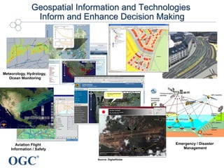
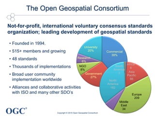
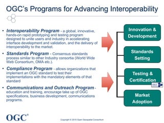
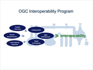
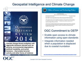
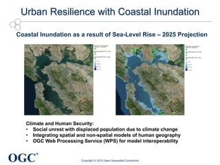
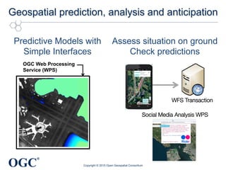
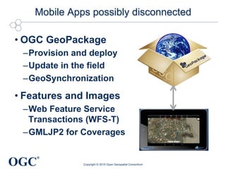
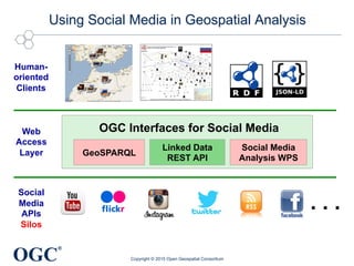
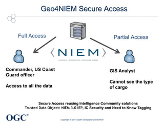
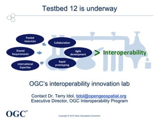
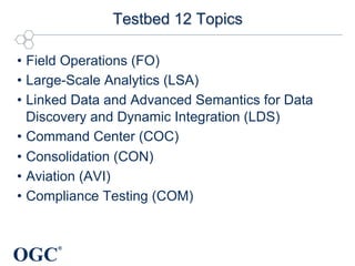
SlideShare a Scribd company logo
1 of 26
Download to read offline
®
OGC Testbed 11 Results
Climate Data Sharing
for Urban Resilience
George Percivall, OGC Chief Engineer, CTO
Mark Reichardt, OGC President and CEO
27 October 2015
Copyright © 2015 Open Geospatial Consortium
OGC
®
Geospatial Information and Technologies
Inform and Enhance Decision Making
Emergency / Disaster
Management
Aviation Flight
Information / Safety
Meteorology, Hydrology,
Ocean Monitoring
Source: DigitalGlobe
OGC
®
Commercial
39%
Government
27%
NGO
8%
Research
6%
University
20%
The Open Geospatial Consortium
Copyright © 2015 Open Geospatial Consortium
Not-for-profit, international voluntary consensus standards
organization; leading development of geospatial standards
•  Founded in 1994.
•  515+ members and growing
•  48 standards
•  Thousands of implementations
•  Broad user community
implementation worldwide
•  Alliances and collaborative activities
with ISO and many other SDO’s
Africa
4
Asia
Pacific
86
Europe
209
Middle
East
34
North
America
182
South
America
3
OGC
®
OGC’s Programs for Advancing Interoperability
•  Interoperability Program - a global, innovative,
hands-on rapid prototyping and testing program
designed to unite users and industry in accelerating
interface development and validation, and the delivery of
interoperability to the market.
•  Standards Program - Consensus standards
process similar to other Industry consortia (World Wide
Web Consortium, OMA etc.).
•  Compliance Program - allows organizations that
implement an OGC standard to test their
implementations with the mandatory elements of that
standard
•  Communications and Outreach Program -
education and training, encourage take up of OGC
specifications, business development, communications
programs.
Innovation &
Development
Standards
Setting
Market
Adoption
Testing &
Certification
Copyright © 2015 Open Geospatial Consortium
OGC
®
Copyright © 2015 Open Geospatial Consortium
OGC Interoperability Program
OGC
®
Climate change pressures are
threat multipliers that will
aggravate stressors abroad such
as poverty, environmental
degradation, political instability,
and social tensions – that enable
terrorist activity and other forms
of violence
 
 
Climate change threat multipliers will
aggravate stressors abroad such as
poverty, environmental degradation,
political instability, and social
tensions – that enable terrorist
activity and other forms of violence
Geospatial Intelligence and Climate Change
Copyright © 2015 Open Geospatial Consortium
THE WHITE HOUSE
Office of Science and Technology Policy
FOR IMMEDIATE RELEASE December 9, 2014
FACT SHEET: Harnessing Climate Data to Boost Ecosystem & Water Resilience
“We're going to have to all work together in the years to come to make sure that we address
the challenge and leave this incredible land embodied to our children and our grandchildren
in at least as good shape as we found it.” – President Barack Obama, Remarks on the
California Drought, February 14, 2014
In March 2014, the Obama Administration launched the Climate Data Initiative, unleashing
troves of open government data about our climate and calling on America’s innovators to
leverage data in ways that can make our Nation’s communities and businesses more
resilient to climate change.
To date, an array of datasets focused on the resilience of our coasts and America’s
agricultural sector have been made available on climate.data.gov and a host of
collaborators across Federal agencies and in the nonprofit, philanthropic, and private
sectors have stepped up, committing to leverage their resources, expertise, and technical
capabilities to turn these data into products and services that can assist people on the
ground.
Today, the Administration is making a new tranche of data about ecosystems and water
resilience available as part of the Climate Data Initiative—including key datasets related
water quality, streamflow, land cover, soils, and biodiversity.
In addition to the datasets being added today to climate.data.gov, the Department of
Interior (DOI) is launching a suite of geospatial mapping tools on ecosystems.data.gov that
will enable users to visualize and overlay datasets related to ecosystems, land use, water,
and wildlife. Together, the data and tools unleashed today will help natural-resource
managers, decision makers, and communities on the front lines of climate change build
resilience to climate impacts and better plan for the future.
To continue momentum under the Climate Data Initiative, the Obama Administration is
today renewing its call to America’s private-sector innovators to leverage open
government data and other resources to build tools that will make U.S. ecosystems and
water resources more resilient to climate change. In response to this call, today’s launch
includes a number of commitments by Federal agencies and private-sector organizations to
combat climate change and support ecosystem and water-resource resilience through data-
driven innovation.
NASA. Climate Resilience Data Challenge. With over $35,000 in prizes, NASA, in
partnership with United States Geological Survey (USGS), will host the Climate Resilience
Data Challenge — an effort to spur data innovation in support of resilience in communities
http://www.whitehouse.gov/sites/default/files/microsites/ostp/cdi-ecosystems-12-9.pdf
OGC Commitment to OSTP
•  Enable open access to climate
information using open standards
•  Integrate information needed
when a population is displaced
due to coastal inundation
OGC
®
Testbed 11 Sponsored by
•  National Aeronautics and Space Administration (NASA)
•  National Geospatial-Intelligence Agency (NGA)
•  US Geological Survey (USGS)
•  Program Manager, Information Sharing Environment
(PM-ISE)
•  UAE Ministry of Interior Abu Dhabi Police GIS Center for
Security (UAE ADP-GIS SC)
•  UK Defense Science and Technology Lab (UK-DSTL)
•  European Organization for the Safety of Air Navigation
(EUROCONTROL)
•  Land Information New Zealand (LINZ)
Copyright © 2015 Open Geospatial Consortium
OGC
®
Testbed Participants
Copyright © 2015 Open Geospatial Consortium
Secure Dimensions
OGC
®
Urban Resilience with Coastal Inundation
Copyright © 2015 Open Geospatial Consortium
Coastal Inundation as a result of Sea-Level Rise – 2025 Projection
Climate and Human Security:
•  Social unrest with displaced population due to climate change
•  Integrating spatial and non-spatial models of human geography
•  OGC Web Processing Service (WPS) for model interoperability
OGC
®
Geospatial prediction, analysis and anticipation
Copyright © 2015 Open Geospatial Consortium
Predictive Models with
Simple Interfaces
Assess situation on ground
Check predictions
!
OGC Web Processing
Service (WPS)
WFS Transaction
Social Media Analysis WPS
OGC
®
Mobile Apps possibly disconnected
• OGC GeoPackage
– Provision and deploy
– Update in the field
– GeoSynchronization
• Features and Images
– Web Feature Service
Transactions (WFS-T)
– GMLJP2 for Coverages
Copyright © 2015 Open Geospatial Consortium
!
OGC
®
Using Social Media in Geospatial Analysis
Copyright © 2015 Open Geospatial Consortium
Social
Media
APIs
Silos
GeoSPARQL
Linked Data
REST API
Web
Access
Layer
Human-
oriented
Clients
. . .
OGC Interfaces for Social Media
Social Media
Analysis WPS
OGC
®
Geo4NIEM Secure Access
Copyright © 2015 Open Geospatial Consortium
Commander, US Coast
Guard officer
Access to all the data
GIS Analyst
Cannot see the type
of cargo
Full Access Partial Access
Secure Access reusing Intelligence Community solutions
Trusted Data Object: NIEM 3.0 IEP, IC Security and Need to Know Tagging
OGC
®
Copyright © 2015 Open Geospatial Consortium
Office of the Director of
National Intelligence
provides standards to
secure data
OGC
®
What to look for in the Testbed 11 video
•  Simplified interaction with predictive models for anticipation
of warnings and opportunities
•  Data collection from network-challenged field operations to
test models and fill in gaps in context
•  Integrated security and open data together providing
content and context to all customers
•  Web-first strategy based on multi-vendor interoperability
Copyright © 2015 Open Geospatial Consortium
Unique innovation process to advance
open access through standards
OGC
®
Testbed 11 Video
Copyright © 2015 Open Geospatial Consortium
OGC Testbed 11 YouTube Playlist
OGC
®
Testbed Results for the Consortium and Public
•  Engineering Reports are the basis for future Standards
Program Development
•  Software developed by participants advances
implementation of open interoperable products
•  Demonstrations provide a vision for policy leadership
•  Basis for the next consortium developments
Copyright © 2015 Open Geospatial Consortium
OGC
®
Benefits of Involvement
For Participants
Early insights and skill building
Early visibility
Early market deployment
Direct influence
Broaden market reach
For Sponsors
Ability to Determine Market
Interest
Accelerated process - workable
interface specifications in 4-6
months
Vendors test, validate and
demonstrate interface integrity –
Rapid time to market
Leverage of other sponsor’
funding to solve common/similar
problems
Significant ROI 2-3.5 overall (and
as high as 25 for individual
sponsors)
Business potentials Significant efficiencies
© 2015, Open Geospatial Consortium
OGC
®
OGC Interoperability Program
© 2014 Open Geospatial Consortium, Inc. 19
•  Aligns technology users and providers to work
collaborativelyCOLLABORATION
•  Agile development environment to develop,
test, and validate standards under marketplace
conditions and foster innovation in the
community
INNOVATION
•  Effective way to share the costs of developing
well-crafted standards that provide concrete
foundations for future enterprise architectures
SHARED COSTS
•  Repeatable process for building & exercising
private-public partnerships to drive global
trends in technology and interoperability
REPEATABLE
PROCESS
OGC
®
Testbed 12 is underway
Copyright © 2015 Open Geospatial Consortium
OGC’s interoperability innovation lab
Contact Dr. Terry Idol, tidol@opengeospatial.org
Executive Director, OGC Interoperability Program
OGC
®
Current Testbed 12 Sponsors
•  National Geospatial-Intelligence Agency (NGA)
•  European Organization for the Safety of Air
Navigation (EUROCONTROL)
•  DigitalGlobe
•  National Aeronautics and Space Administration
(NASA)
•  UK Defense Science and Technology Lab
(UK-DSTL)
•  US Geological Survey (USGS)
•  Federal Aviation Administration (FAA)
Copyright © 2015 Open Geospatial Consortium
OGC
®
Testbed 12 Topics
•  Field Operations (FO)
•  Large-Scale Analytics (LSA)
•  Linked Data and Advanced Semantics for Data
Discovery and Dynamic Integration (LDS)
•  Command Center (COC)
•  Consolidation (CON)
•  Aviation (AVI)
•  Compliance Testing (COM)
OGC
®
Key Tentative Dates Testbed 12
•  May 2015 Testbed 12 planning phase launch
•  23 Oct 2015 Release Testbed 12 Request for
Quotation / Call for Participation
•  20 Nov 2015 Last day to submit proposals for Testbed
•  19 Jan 2016 Kick-Off workshop for Testbed 12 TBD
(3 days)
•  Sept 2016 Demonstration of Testbed 12
Results
OGC
®
OGC Interoperability Program Continuum
Interoperability
Experiment
Plugfest
OGC Network
Pilot
Specifications
Implementations
Demonstrations
Types of Interoperability Program Initiatives
Testbed
Standards
Program
Copyright © 2015 Open Geospatial Consortium
OGC
®
Proposed Climate Resilience Pilot
•  Concept
–  Base on Testbed 11 results of connecting science community with
the response community
–  Application of Climate Information to Resilience Preparedness
•  USGCRP National Climate assessment, Datasets
•  Climate Data Initiative and Climate Data Analysis Tools
•  Industry capabilities
–  Connect with Smart City and infrastructure resilience
–  “providing knowledge useful for informing decisions”
•  Anticipated Outcomes
–  Implement administration objectives in operational environment
–  Open Data sharing up to Technology Readiness Level 7
–  Best Practices for open access for climate resilience planning
Copyright © 2015 Open Geospatial Consortium
OGC
®
Join the OGC
Open Geospatial Consortium
www.opengeospatial.org
OGC Standards - freely available
www.opengeospatial.org/standards
OGC on YouTube
http://www.youtube.com/user/ogcvideo
George Percivall
gpercivall@opengeospatial.org
Copyright © 2015 Open Geospatial Consortium

More Related Content

What's hot

OGC Update for State of Geospatial Tech at T-Rex
OGC Update for State of Geospatial Tech at T-RexOGC Update for State of Geospatial Tech at T-Rex
OGC Update for State of Geospatial Tech at T-RexGeorge Percivall
 
Analysis Ready Data workshop - OGC presentation
Analysis Ready Data workshop - OGC presentation Analysis Ready Data workshop - OGC presentation
Analysis Ready Data workshop - OGC presentation George Percivall
 
Time, Change and Habits in Geospatial-Temporal Information Standards
Time, Change and Habits in Geospatial-Temporal Information StandardsTime, Change and Habits in Geospatial-Temporal Information Standards
Time, Change and Habits in Geospatial-Temporal Information StandardsGeorge Percivall
 
CyberGIS Architectures for Collaborative Problem Solving - OGC perspective
CyberGIS Architectures for Collaborative Problem Solving - OGC perspectiveCyberGIS Architectures for Collaborative Problem Solving - OGC perspective
CyberGIS Architectures for Collaborative Problem Solving - OGC perspectiveGeorge Percivall
 
Evolution of System Architectures: Where Do We Need to Fail Next?
Evolution of System Architectures: Where Do We Need to Fail Next?Evolution of System Architectures: Where Do We Need to Fail Next?
Evolution of System Architectures: Where Do We Need to Fail Next?Luis Bermudez
 
Application packaging and systematic processing in earth observation exploita...
Application packaging and systematic processing in earth observation exploita...Application packaging and systematic processing in earth observation exploita...
Application packaging and systematic processing in earth observation exploita...terradue
 
Using GEM’S Tools and Datasets for Calculating Hazard Across the Globe
Using GEM’S Tools and Datasets for Calculating Hazard Across the GlobeUsing GEM’S Tools and Datasets for Calculating Hazard Across the Globe
Using GEM’S Tools and Datasets for Calculating Hazard Across the GlobeGlobal Earthquake Model Foundation
 
Standards and Oil Spill Response
Standards and Oil Spill ResponseStandards and Oil Spill Response
Standards and Oil Spill ResponseGeorge Percivall
 
Mapping the Tohoku 2011 Tsunami event with a remote sensing satellite constel...
Mapping the Tohoku 2011 Tsunami event with a remote sensing satellite constel...Mapping the Tohoku 2011 Tsunami event with a remote sensing satellite constel...
Mapping the Tohoku 2011 Tsunami event with a remote sensing satellite constel...Peter Löwe
 
EODATASERVICE.ORG - Digital Earth Platform to enable Muti-disciplinary Geospa...
EODATASERVICE.ORG - Digital Earth Platform to enable Muti-disciplinary Geospa...EODATASERVICE.ORG - Digital Earth Platform to enable Muti-disciplinary Geospa...
EODATASERVICE.ORG - Digital Earth Platform to enable Muti-disciplinary Geospa...EUDAT
 
GEM Risk: main achievements during the first implementation phase
GEM Risk: main achievements during the first implementation phaseGEM Risk: main achievements during the first implementation phase
GEM Risk: main achievements during the first implementation phaseGlobal Earthquake Model Foundation
 
Expert judgment-based fragility functions to better characterize physical vu...
Expert judgment-based fragility functions to better characterize physical vu...Expert judgment-based fragility functions to better characterize physical vu...
Expert judgment-based fragility functions to better characterize physical vu...Global Earthquake Model Foundation
 
The Seismic Hazard Modeller’s Toolkit: An Open-Source Library for the Const...
The Seismic Hazard Modeller’s Toolkit:  An Open-Source Library for the Const...The Seismic Hazard Modeller’s Toolkit:  An Open-Source Library for the Const...
The Seismic Hazard Modeller’s Toolkit: An Open-Source Library for the Const...Global Earthquake Model Foundation
 
TexelTek - Andrew Levine - Hadoop World 2010
TexelTek - Andrew Levine - Hadoop World 2010TexelTek - Andrew Levine - Hadoop World 2010
TexelTek - Andrew Levine - Hadoop World 2010Cloudera, Inc.
 
Open Science and GEOSS: the Cloud Sandbox enablers
Open Science and GEOSS: the Cloud Sandbox enablersOpen Science and GEOSS: the Cloud Sandbox enablers
Open Science and GEOSS: the Cloud Sandbox enablersterradue
 

What's hot (20)

OGC Update for State of Geospatial Tech at T-Rex
OGC Update for State of Geospatial Tech at T-RexOGC Update for State of Geospatial Tech at T-Rex
OGC Update for State of Geospatial Tech at T-Rex
 
Analysis Ready Data workshop - OGC presentation
Analysis Ready Data workshop - OGC presentation Analysis Ready Data workshop - OGC presentation
Analysis Ready Data workshop - OGC presentation
 
Time, Change and Habits in Geospatial-Temporal Information Standards
Time, Change and Habits in Geospatial-Temporal Information StandardsTime, Change and Habits in Geospatial-Temporal Information Standards
Time, Change and Habits in Geospatial-Temporal Information Standards
 
CyberGIS Architectures for Collaborative Problem Solving - OGC perspective
CyberGIS Architectures for Collaborative Problem Solving - OGC perspectiveCyberGIS Architectures for Collaborative Problem Solving - OGC perspective
CyberGIS Architectures for Collaborative Problem Solving - OGC perspective
 
Evolution of System Architectures: Where Do We Need to Fail Next?
Evolution of System Architectures: Where Do We Need to Fail Next?Evolution of System Architectures: Where Do We Need to Fail Next?
Evolution of System Architectures: Where Do We Need to Fail Next?
 
Application packaging and systematic processing in earth observation exploita...
Application packaging and systematic processing in earth observation exploita...Application packaging and systematic processing in earth observation exploita...
Application packaging and systematic processing in earth observation exploita...
 
Using GEM’S Tools and Datasets for Calculating Hazard Across the Globe
Using GEM’S Tools and Datasets for Calculating Hazard Across the GlobeUsing GEM’S Tools and Datasets for Calculating Hazard Across the Globe
Using GEM’S Tools and Datasets for Calculating Hazard Across the Globe
 
Standards and Oil Spill Response
Standards and Oil Spill ResponseStandards and Oil Spill Response
Standards and Oil Spill Response
 
GEM’s hazard products: outcomes and applications
GEM’s hazard products: outcomes and applicationsGEM’s hazard products: outcomes and applications
GEM’s hazard products: outcomes and applications
 
Mapping the Tohoku 2011 Tsunami event with a remote sensing satellite constel...
Mapping the Tohoku 2011 Tsunami event with a remote sensing satellite constel...Mapping the Tohoku 2011 Tsunami event with a remote sensing satellite constel...
Mapping the Tohoku 2011 Tsunami event with a remote sensing satellite constel...
 
Mapping the Tohoku 2011 Tsunami event with a remote sensing satellite constel...
Mapping the Tohoku 2011 Tsunami event with a remote sensing satellite constel...Mapping the Tohoku 2011 Tsunami event with a remote sensing satellite constel...
Mapping the Tohoku 2011 Tsunami event with a remote sensing satellite constel...
 
EODATASERVICE.ORG - Digital Earth Platform to enable Muti-disciplinary Geospa...
EODATASERVICE.ORG - Digital Earth Platform to enable Muti-disciplinary Geospa...EODATASERVICE.ORG - Digital Earth Platform to enable Muti-disciplinary Geospa...
EODATASERVICE.ORG - Digital Earth Platform to enable Muti-disciplinary Geospa...
 
GEM Risk: main achievements during the first implementation phase
GEM Risk: main achievements during the first implementation phaseGEM Risk: main achievements during the first implementation phase
GEM Risk: main achievements during the first implementation phase
 
Expert judgment-based fragility functions to better characterize physical vu...
Expert judgment-based fragility functions to better characterize physical vu...Expert judgment-based fragility functions to better characterize physical vu...
Expert judgment-based fragility functions to better characterize physical vu...
 
The Seismic Hazard Modeller’s Toolkit: An Open-Source Library for the Const...
The Seismic Hazard Modeller’s Toolkit:  An Open-Source Library for the Const...The Seismic Hazard Modeller’s Toolkit:  An Open-Source Library for the Const...
The Seismic Hazard Modeller’s Toolkit: An Open-Source Library for the Const...
 
EMME Earthquake Model of Middle East
EMME Earthquake Model of Middle EastEMME Earthquake Model of Middle East
EMME Earthquake Model of Middle East
 
TexelTek - Andrew Levine - Hadoop World 2010
TexelTek - Andrew Levine - Hadoop World 2010TexelTek - Andrew Levine - Hadoop World 2010
TexelTek - Andrew Levine - Hadoop World 2010
 
Open Science and GEOSS: the Cloud Sandbox enablers
Open Science and GEOSS: the Cloud Sandbox enablersOpen Science and GEOSS: the Cloud Sandbox enablers
Open Science and GEOSS: the Cloud Sandbox enablers
 
Intel_IoT_Munich
Intel_IoT_MunichIntel_IoT_Munich
Intel_IoT_Munich
 
DGdefranceschi
DGdefranceschiDGdefranceschi
DGdefranceschi
 

Viewers also liked

Edwards climate data detectives - yale 2-2015
Edwards   climate data detectives - yale 2-2015Edwards   climate data detectives - yale 2-2015
Edwards climate data detectives - yale 2-2015Paul Edwards
 
ICLR Friday Forum: Climate data in Ontario (November 13, 2015)
ICLR Friday Forum: Climate data in Ontario (November 13, 2015)ICLR Friday Forum: Climate data in Ontario (November 13, 2015)
ICLR Friday Forum: Climate data in Ontario (November 13, 2015)glennmcgillivray
 
Interpreting Climate Data - Analysing climate vulnerability- online training ...
Interpreting Climate Data - Analysing climate vulnerability- online training ...Interpreting Climate Data - Analysing climate vulnerability- online training ...
Interpreting Climate Data - Analysing climate vulnerability- online training ...Vestlandsforsking WRNI
 
20090701 Climate Data Staging
20090701 Climate Data Staging20090701 Climate Data Staging
20090701 Climate Data StagingHenning Bergmeyer
 
Contextualizing the Visualization of Climate Data
Contextualizing the Visualization of Climate DataContextualizing the Visualization of Climate Data
Contextualizing the Visualization of Climate DataRaquel Alegre
 
Document IT Communicate IT Succeed
Document IT Communicate IT SucceedDocument IT Communicate IT Succeed
Document IT Communicate IT SucceedDeborah Gleason
 
Data recovery saudi arabia
Data recovery saudi arabiaData recovery saudi arabia
Data recovery saudi arabiaDolphin Data Lab
 
ESRI User Conference 2014 - A Location Aware Mobile Tool for Direct and Indir...
ESRI User Conference 2014 - A Location Aware Mobile Tool for Direct and Indir...ESRI User Conference 2014 - A Location Aware Mobile Tool for Direct and Indir...
ESRI User Conference 2014 - A Location Aware Mobile Tool for Direct and Indir...Francisco Ramos
 
Saudi arabia climate policy report
Saudi arabia climate policy reportSaudi arabia climate policy report
Saudi arabia climate policy reportAaron Dorman
 
Geography Water
Geography WaterGeography Water
Geography WaterDaniela L
 
Collaborate 2012: Environmental Accounting and Reporting
Collaborate 2012: Environmental Accounting and ReportingCollaborate 2012: Environmental Accounting and Reporting
Collaborate 2012: Environmental Accounting and ReportingAngela Miller
 
Saudi arabia presentation
Saudi arabia presentationSaudi arabia presentation
Saudi arabia presentationbpdow12
 
BigDataEurope - Big Data & Climate Change
BigDataEurope - Big Data & Climate ChangeBigDataEurope - Big Data & Climate Change
BigDataEurope - Big Data & Climate ChangeBigData_Europe
 
Saudi Aramco Carbon Management - May 2013
Saudi Aramco Carbon Management - May 2013Saudi Aramco Carbon Management - May 2013
Saudi Aramco Carbon Management - May 2013Global CCS Institute
 
The Role of DAta for Climate Monitoring and Prediction
The Role of DAta for Climate Monitoring and PredictionThe Role of DAta for Climate Monitoring and Prediction
The Role of DAta for Climate Monitoring and PredictionNAP Events
 

Viewers also liked (20)

Edwards climate data detectives - yale 2-2015
Edwards   climate data detectives - yale 2-2015Edwards   climate data detectives - yale 2-2015
Edwards climate data detectives - yale 2-2015
 
Andreas Hense: Climate data for our future – acquired, analysed, archived
Andreas Hense: Climate data for our future – acquired, analysed, archivedAndreas Hense: Climate data for our future – acquired, analysed, archived
Andreas Hense: Climate data for our future – acquired, analysed, archived
 
ICLR Friday Forum: Climate data in Ontario (November 13, 2015)
ICLR Friday Forum: Climate data in Ontario (November 13, 2015)ICLR Friday Forum: Climate data in Ontario (November 13, 2015)
ICLR Friday Forum: Climate data in Ontario (November 13, 2015)
 
Climate data in R with the raster package
Climate data in R with the raster packageClimate data in R with the raster package
Climate data in R with the raster package
 
Interpreting Climate Data - Analysing climate vulnerability- online training ...
Interpreting Climate Data - Analysing climate vulnerability- online training ...Interpreting Climate Data - Analysing climate vulnerability- online training ...
Interpreting Climate Data - Analysing climate vulnerability- online training ...
 
20090701 Climate Data Staging
20090701 Climate Data Staging20090701 Climate Data Staging
20090701 Climate Data Staging
 
Contextualizing the Visualization of Climate Data
Contextualizing the Visualization of Climate DataContextualizing the Visualization of Climate Data
Contextualizing the Visualization of Climate Data
 
Document IT Communicate IT Succeed
Document IT Communicate IT SucceedDocument IT Communicate IT Succeed
Document IT Communicate IT Succeed
 
Data recovery saudi arabia
Data recovery saudi arabiaData recovery saudi arabia
Data recovery saudi arabia
 
ESRI User Conference 2014 - A Location Aware Mobile Tool for Direct and Indir...
ESRI User Conference 2014 - A Location Aware Mobile Tool for Direct and Indir...ESRI User Conference 2014 - A Location Aware Mobile Tool for Direct and Indir...
ESRI User Conference 2014 - A Location Aware Mobile Tool for Direct and Indir...
 
Saudi arabia climate policy report
Saudi arabia climate policy reportSaudi arabia climate policy report
Saudi arabia climate policy report
 
Geography Water
Geography WaterGeography Water
Geography Water
 
Collaborate 2012: Environmental Accounting and Reporting
Collaborate 2012: Environmental Accounting and ReportingCollaborate 2012: Environmental Accounting and Reporting
Collaborate 2012: Environmental Accounting and Reporting
 
Saudi arabia presentation
Saudi arabia presentationSaudi arabia presentation
Saudi arabia presentation
 
Making Climate Data Sing
Making Climate Data SingMaking Climate Data Sing
Making Climate Data Sing
 
BigDataEurope - Big Data & Climate Change
BigDataEurope - Big Data & Climate ChangeBigDataEurope - Big Data & Climate Change
BigDataEurope - Big Data & Climate Change
 
Saudi Aramco Carbon Management - May 2013
Saudi Aramco Carbon Management - May 2013Saudi Aramco Carbon Management - May 2013
Saudi Aramco Carbon Management - May 2013
 
The Role of DAta for Climate Monitoring and Prediction
The Role of DAta for Climate Monitoring and PredictionThe Role of DAta for Climate Monitoring and Prediction
The Role of DAta for Climate Monitoring and Prediction
 
Non-renewable groundwater management in Saudi Arabia
Non-renewable groundwater management in Saudi ArabiaNon-renewable groundwater management in Saudi Arabia
Non-renewable groundwater management in Saudi Arabia
 
Gulf Region
Gulf RegionGulf Region
Gulf Region
 

Similar to Climate Data Sharing for Urban Resilience - OGC Testbed 11

Ramage EO4SDG keynote August 2019
Ramage EO4SDG keynote August 2019Ramage EO4SDG keynote August 2019
Ramage EO4SDG keynote August 2019Steven Ramage
 
Locate15 Conference - Brisbane, Australia
Locate15 Conference - Brisbane, AustraliaLocate15 Conference - Brisbane, Australia
Locate15 Conference - Brisbane, AustraliaPLACE
 
Keynote, Oman Geospatial Expo, Dec 2013
Keynote, Oman Geospatial Expo, Dec 2013Keynote, Oman Geospatial Expo, Dec 2013
Keynote, Oman Geospatial Expo, Dec 2013Steven Ramage
 
Steven Ramage OGC OSGIS 2010
Steven Ramage OGC OSGIS 2010Steven Ramage OGC OSGIS 2010
Steven Ramage OGC OSGIS 2010Steven Ramage
 
GEO101 FOSS4G August 2019
GEO101 FOSS4G August 2019GEO101 FOSS4G August 2019
GEO101 FOSS4G August 2019Steven Ramage
 
ISRSE37 Terradue Cloud Platform & ellip
ISRSE37 Terradue Cloud Platform & ellipISRSE37 Terradue Cloud Platform & ellip
ISRSE37 Terradue Cloud Platform & ellipterradue
 
2013 keynote com.geo_reed v2
2013 keynote com.geo_reed v22013 keynote com.geo_reed v2
2013 keynote com.geo_reed v2Carl Reed
 
Research + Private Sector Partnerships - Climate information for social and e...
Research + Private Sector Partnerships - Climate information for social and e...Research + Private Sector Partnerships - Climate information for social and e...
Research + Private Sector Partnerships - Climate information for social and e...UCAR - Atmospheric & Earth System Science
 
Nuno Catarino: NextGEOSS project
Nuno Catarino: NextGEOSS projectNuno Catarino: NextGEOSS project
Nuno Catarino: NextGEOSS projectEOSC-hub project
 
C0.5: CEOS and Oceans - Chu Ishida, Alex Held
C0.5: CEOS and Oceans - Chu Ishida, Alex HeldC0.5: CEOS and Oceans - Chu Ishida, Alex Held
C0.5: CEOS and Oceans - Chu Ishida, Alex HeldBlue Planet Symposium
 
Cloud processing close to the Earth data
Cloud processing close to the Earth dataCloud processing close to the Earth data
Cloud processing close to the Earth dataterradue
 
Data Collaboration and Stewardship for the Blue Economy
Data Collaboration and Stewardship for the Blue EconomyData Collaboration and Stewardship for the Blue Economy
Data Collaboration and Stewardship for the Blue EconomyStefaan Verhulst
 
Ramage Keynote ISPRS Geospatial Week 2017
Ramage Keynote ISPRS Geospatial Week 2017Ramage Keynote ISPRS Geospatial Week 2017
Ramage Keynote ISPRS Geospatial Week 2017Steven Ramage
 
NOAA Big Data Project Handout
NOAA Big Data Project HandoutNOAA Big Data Project Handout
NOAA Big Data Project HandoutAmy Gaskins
 
C1.06: US IOOS: Eyes on the Ocean - Zdenka Willis
C1.06: US IOOS: Eyes on the Ocean - Zdenka WillisC1.06: US IOOS: Eyes on the Ocean - Zdenka Willis
C1.06: US IOOS: Eyes on the Ocean - Zdenka WillisBlue Planet Symposium
 
Falcon sdi oct update
Falcon sdi oct updateFalcon sdi oct update
Falcon sdi oct updateict4dev
 
Introduction to vcs jnr (south south jnr workshop, manaus) 13 jun 13 for dist
Introduction to vcs jnr (south south jnr workshop, manaus) 13 jun 13 for distIntroduction to vcs jnr (south south jnr workshop, manaus) 13 jun 13 for dist
Introduction to vcs jnr (south south jnr workshop, manaus) 13 jun 13 for distIdesam
 

Similar to Climate Data Sharing for Urban Resilience - OGC Testbed 11 (20)

Ramage EO4SDG keynote August 2019
Ramage EO4SDG keynote August 2019Ramage EO4SDG keynote August 2019
Ramage EO4SDG keynote August 2019
 
Locate15 Conference - Brisbane, Australia
Locate15 Conference - Brisbane, AustraliaLocate15 Conference - Brisbane, Australia
Locate15 Conference - Brisbane, Australia
 
Keynote, Oman Geospatial Expo, Dec 2013
Keynote, Oman Geospatial Expo, Dec 2013Keynote, Oman Geospatial Expo, Dec 2013
Keynote, Oman Geospatial Expo, Dec 2013
 
GEM's Mission and Vision [Sep 2012]
GEM's Mission and Vision [Sep 2012]GEM's Mission and Vision [Sep 2012]
GEM's Mission and Vision [Sep 2012]
 
Steven Ramage OGC OSGIS 2010
Steven Ramage OGC OSGIS 2010Steven Ramage OGC OSGIS 2010
Steven Ramage OGC OSGIS 2010
 
GEO101 FOSS4G August 2019
GEO101 FOSS4G August 2019GEO101 FOSS4G August 2019
GEO101 FOSS4G August 2019
 
MYGEOSS Project
MYGEOSS ProjectMYGEOSS Project
MYGEOSS Project
 
ISRSE37 Terradue Cloud Platform & ellip
ISRSE37 Terradue Cloud Platform & ellipISRSE37 Terradue Cloud Platform & ellip
ISRSE37 Terradue Cloud Platform & ellip
 
2013 keynote com.geo_reed v2
2013 keynote com.geo_reed v22013 keynote com.geo_reed v2
2013 keynote com.geo_reed v2
 
Research + Private Sector Partnerships - Climate information for social and e...
Research + Private Sector Partnerships - Climate information for social and e...Research + Private Sector Partnerships - Climate information for social and e...
Research + Private Sector Partnerships - Climate information for social and e...
 
Nuno Catarino: NextGEOSS project
Nuno Catarino: NextGEOSS projectNuno Catarino: NextGEOSS project
Nuno Catarino: NextGEOSS project
 
C0.5: CEOS and Oceans - Chu Ishida, Alex Held
C0.5: CEOS and Oceans - Chu Ishida, Alex HeldC0.5: CEOS and Oceans - Chu Ishida, Alex Held
C0.5: CEOS and Oceans - Chu Ishida, Alex Held
 
Cloud processing close to the Earth data
Cloud processing close to the Earth dataCloud processing close to the Earth data
Cloud processing close to the Earth data
 
Data Collaboration and Stewardship for the Blue Economy
Data Collaboration and Stewardship for the Blue EconomyData Collaboration and Stewardship for the Blue Economy
Data Collaboration and Stewardship for the Blue Economy
 
Ramage Keynote ISPRS Geospatial Week 2017
Ramage Keynote ISPRS Geospatial Week 2017Ramage Keynote ISPRS Geospatial Week 2017
Ramage Keynote ISPRS Geospatial Week 2017
 
NOAA Big Data Project Handout
NOAA Big Data Project HandoutNOAA Big Data Project Handout
NOAA Big Data Project Handout
 
LinkedIn-Presentations
LinkedIn-PresentationsLinkedIn-Presentations
LinkedIn-Presentations
 
C1.06: US IOOS: Eyes on the Ocean - Zdenka Willis
C1.06: US IOOS: Eyes on the Ocean - Zdenka WillisC1.06: US IOOS: Eyes on the Ocean - Zdenka Willis
C1.06: US IOOS: Eyes on the Ocean - Zdenka Willis
 
Falcon sdi oct update
Falcon sdi oct updateFalcon sdi oct update
Falcon sdi oct update
 
Introduction to vcs jnr (south south jnr workshop, manaus) 13 jun 13 for dist
Introduction to vcs jnr (south south jnr workshop, manaus) 13 jun 13 for distIntroduction to vcs jnr (south south jnr workshop, manaus) 13 jun 13 for dist
Introduction to vcs jnr (south south jnr workshop, manaus) 13 jun 13 for dist
 

More from George Percivall

Geography of Digital Earth
Geography of Digital EarthGeography of Digital Earth
Geography of Digital EarthGeorge Percivall
 
Spatial Computing and the Future of Utility GIS
Spatial Computing and the Future of Utility GISSpatial Computing and the Future of Utility GIS
Spatial Computing and the Future of Utility GISGeorge Percivall
 
Big Geo Data: Open Source and Open Standards
Big Geo Data: Open Source and Open StandardsBig Geo Data: Open Source and Open Standards
Big Geo Data: Open Source and Open StandardsGeorge Percivall
 
Manual on Remote Sensing v4 - Chapter 6 archive and access
Manual on Remote Sensing v4 - Chapter 6 archive and accessManual on Remote Sensing v4 - Chapter 6 archive and access
Manual on Remote Sensing v4 - Chapter 6 archive and accessGeorge Percivall
 
Urban IoT for Smart Cities: New Pathways to Business and Location Intelligenc...
Urban IoT for Smart Cities: New Pathways to Business and Location Intelligenc...Urban IoT for Smart Cities: New Pathways to Business and Location Intelligenc...
Urban IoT for Smart Cities: New Pathways to Business and Location Intelligenc...George Percivall
 
OGC standards relevant to ISPRS
OGC standards relevant to ISPRSOGC standards relevant to ISPRS
OGC standards relevant to ISPRSGeorge Percivall
 
Innovation in Geospatial Technology and Standards
Innovation in Geospatial Technology and StandardsInnovation in Geospatial Technology and Standards
Innovation in Geospatial Technology and StandardsGeorge Percivall
 
The power of location information for mobile
The power of location information for mobileThe power of location information for mobile
The power of location information for mobileGeorge Percivall
 
The Open Landscape of Geospatial Information:
The Open Landscape of Geospatial Information:The Open Landscape of Geospatial Information:
The Open Landscape of Geospatial Information:George Percivall
 
Location Based Services update for Small Cell Forum
Location Based Services update for Small Cell ForumLocation Based Services update for Small Cell Forum
Location Based Services update for Small Cell ForumGeorge Percivall
 

More from George Percivall (11)

Geography of Digital Earth
Geography of Digital EarthGeography of Digital Earth
Geography of Digital Earth
 
Spatial Computing and the Future of Utility GIS
Spatial Computing and the Future of Utility GISSpatial Computing and the Future of Utility GIS
Spatial Computing and the Future of Utility GIS
 
Big Geo Data: Open Source and Open Standards
Big Geo Data: Open Source and Open StandardsBig Geo Data: Open Source and Open Standards
Big Geo Data: Open Source and Open Standards
 
Manual on Remote Sensing v4 - Chapter 6 archive and access
Manual on Remote Sensing v4 - Chapter 6 archive and accessManual on Remote Sensing v4 - Chapter 6 archive and access
Manual on Remote Sensing v4 - Chapter 6 archive and access
 
Urban IoT for Smart Cities: New Pathways to Business and Location Intelligenc...
Urban IoT for Smart Cities: New Pathways to Business and Location Intelligenc...Urban IoT for Smart Cities: New Pathways to Business and Location Intelligenc...
Urban IoT for Smart Cities: New Pathways to Business and Location Intelligenc...
 
OGC standards relevant to ISPRS
OGC standards relevant to ISPRSOGC standards relevant to ISPRS
OGC standards relevant to ISPRS
 
Innovation in Geospatial Technology and Standards
Innovation in Geospatial Technology and StandardsInnovation in Geospatial Technology and Standards
Innovation in Geospatial Technology and Standards
 
The power of location information for mobile
The power of location information for mobileThe power of location information for mobile
The power of location information for mobile
 
The Open Landscape of Geospatial Information:
The Open Landscape of Geospatial Information:The Open Landscape of Geospatial Information:
The Open Landscape of Geospatial Information:
 
Location Based Services update for Small Cell Forum
Location Based Services update for Small Cell ForumLocation Based Services update for Small Cell Forum
Location Based Services update for Small Cell Forum
 
Geospatial trends
Geospatial trendsGeospatial trends
Geospatial trends
 

Recently uploaded

Cloud Management Software Platforms: OpenStack
Cloud Management Software Platforms: OpenStackCloud Management Software Platforms: OpenStack
Cloud Management Software Platforms: OpenStackVICTOR MAESTRE RAMIREZ
 
Short Story: Unveiling the Reasoning Abilities of Large Language Models by Ke...
Short Story: Unveiling the Reasoning Abilities of Large Language Models by Ke...Short Story: Unveiling the Reasoning Abilities of Large Language Models by Ke...
Short Story: Unveiling the Reasoning Abilities of Large Language Models by Ke...kellynguyen01
 
Learn the Fundamentals of XCUITest Framework_ A Beginner's Guide.pdf
Learn the Fundamentals of XCUITest Framework_ A Beginner's Guide.pdfLearn the Fundamentals of XCUITest Framework_ A Beginner's Guide.pdf
Learn the Fundamentals of XCUITest Framework_ A Beginner's Guide.pdfkalichargn70th171
 
Der Spagat zwischen BIAS und FAIRNESS (2024)
Der Spagat zwischen BIAS und FAIRNESS (2024)Der Spagat zwischen BIAS und FAIRNESS (2024)
Der Spagat zwischen BIAS und FAIRNESS (2024)OPEN KNOWLEDGE GmbH
 
Russian Call Girls in Karol Bagh Aasnvi ➡️ 8264348440 💋📞 Independent Escort S...
Russian Call Girls in Karol Bagh Aasnvi ➡️ 8264348440 💋📞 Independent Escort S...Russian Call Girls in Karol Bagh Aasnvi ➡️ 8264348440 💋📞 Independent Escort S...
Russian Call Girls in Karol Bagh Aasnvi ➡️ 8264348440 💋📞 Independent Escort S...soniya singh
 
XpertSolvers: Your Partner in Building Innovative Software Solutions
XpertSolvers: Your Partner in Building Innovative Software SolutionsXpertSolvers: Your Partner in Building Innovative Software Solutions
XpertSolvers: Your Partner in Building Innovative Software SolutionsMehedi Hasan Shohan
 
HR Software Buyers Guide in 2024 - HRSoftware.com
HR Software Buyers Guide in 2024 - HRSoftware.comHR Software Buyers Guide in 2024 - HRSoftware.com
HR Software Buyers Guide in 2024 - HRSoftware.comFatema Valibhai
 
Optimizing AI for immediate response in Smart CCTV
Optimizing AI for immediate response in Smart CCTVOptimizing AI for immediate response in Smart CCTV
Optimizing AI for immediate response in Smart CCTVshikhaohhpro
 
The Evolution of Karaoke From Analog to App.pdf
The Evolution of Karaoke From Analog to App.pdfThe Evolution of Karaoke From Analog to App.pdf
The Evolution of Karaoke From Analog to App.pdfPower Karaoke
 
Salesforce Certified Field Service Consultant
Salesforce Certified Field Service ConsultantSalesforce Certified Field Service Consultant
Salesforce Certified Field Service ConsultantAxelRicardoTrocheRiq
 
Unit 1.1 Excite Part 1, class 9, cbse...
Unit 1.1 Excite Part 1, class 9, cbse...Unit 1.1 Excite Part 1, class 9, cbse...
Unit 1.1 Excite Part 1, class 9, cbse...aditisharan08
 
The Real-World Challenges of Medical Device Cybersecurity- Mitigating Vulnera...
The Real-World Challenges of Medical Device Cybersecurity- Mitigating Vulnera...The Real-World Challenges of Medical Device Cybersecurity- Mitigating Vulnera...
The Real-World Challenges of Medical Device Cybersecurity- Mitigating Vulnera...ICS
 
Hand gesture recognition PROJECT PPT.pptx
Hand gesture recognition PROJECT PPT.pptxHand gesture recognition PROJECT PPT.pptx
Hand gesture recognition PROJECT PPT.pptxbodapatigopi8531
 
Building a General PDE Solving Framework with Symbolic-Numeric Scientific Mac...
Building a General PDE Solving Framework with Symbolic-Numeric Scientific Mac...Building a General PDE Solving Framework with Symbolic-Numeric Scientific Mac...
Building a General PDE Solving Framework with Symbolic-Numeric Scientific Mac...stazi3110
 
why an Opensea Clone Script might be your perfect match.pdf
why an Opensea Clone Script might be your perfect match.pdfwhy an Opensea Clone Script might be your perfect match.pdf
why an Opensea Clone Script might be your perfect match.pdfjoe51371421
 
(Genuine) Escort Service Lucknow | Starting ₹,5K To @25k with A/C 🧑🏽‍❤️‍🧑🏻 89...
(Genuine) Escort Service Lucknow | Starting ₹,5K To @25k with A/C 🧑🏽‍❤️‍🧑🏻 89...(Genuine) Escort Service Lucknow | Starting ₹,5K To @25k with A/C 🧑🏽‍❤️‍🧑🏻 89...
(Genuine) Escort Service Lucknow | Starting ₹,5K To @25k with A/C 🧑🏽‍❤️‍🧑🏻 89...gurkirankumar98700
 
EY_Graph Database Powered Sustainability
EY_Graph Database Powered SustainabilityEY_Graph Database Powered Sustainability
EY_Graph Database Powered SustainabilityNeo4j
 
Advancing Engineering with AI through the Next Generation of Strategic Projec...
Advancing Engineering with AI through the Next Generation of Strategic Projec...Advancing Engineering with AI through the Next Generation of Strategic Projec...
Advancing Engineering with AI through the Next Generation of Strategic Projec...OnePlan Solutions
 
Building Real-Time Data Pipelines: Stream & Batch Processing workshop Slide
Building Real-Time Data Pipelines: Stream & Batch Processing workshop SlideBuilding Real-Time Data Pipelines: Stream & Batch Processing workshop Slide
Building Real-Time Data Pipelines: Stream & Batch Processing workshop SlideChristina Lin
 

Recently uploaded (20)

Cloud Management Software Platforms: OpenStack
Cloud Management Software Platforms: OpenStackCloud Management Software Platforms: OpenStack
Cloud Management Software Platforms: OpenStack
 
Short Story: Unveiling the Reasoning Abilities of Large Language Models by Ke...
Short Story: Unveiling the Reasoning Abilities of Large Language Models by Ke...Short Story: Unveiling the Reasoning Abilities of Large Language Models by Ke...
Short Story: Unveiling the Reasoning Abilities of Large Language Models by Ke...
 
Learn the Fundamentals of XCUITest Framework_ A Beginner's Guide.pdf
Learn the Fundamentals of XCUITest Framework_ A Beginner's Guide.pdfLearn the Fundamentals of XCUITest Framework_ A Beginner's Guide.pdf
Learn the Fundamentals of XCUITest Framework_ A Beginner's Guide.pdf
 
Der Spagat zwischen BIAS und FAIRNESS (2024)
Der Spagat zwischen BIAS und FAIRNESS (2024)Der Spagat zwischen BIAS und FAIRNESS (2024)
Der Spagat zwischen BIAS und FAIRNESS (2024)
 
Russian Call Girls in Karol Bagh Aasnvi ➡️ 8264348440 💋📞 Independent Escort S...
Russian Call Girls in Karol Bagh Aasnvi ➡️ 8264348440 💋📞 Independent Escort S...Russian Call Girls in Karol Bagh Aasnvi ➡️ 8264348440 💋📞 Independent Escort S...
Russian Call Girls in Karol Bagh Aasnvi ➡️ 8264348440 💋📞 Independent Escort S...
 
XpertSolvers: Your Partner in Building Innovative Software Solutions
XpertSolvers: Your Partner in Building Innovative Software SolutionsXpertSolvers: Your Partner in Building Innovative Software Solutions
XpertSolvers: Your Partner in Building Innovative Software Solutions
 
HR Software Buyers Guide in 2024 - HRSoftware.com
HR Software Buyers Guide in 2024 - HRSoftware.comHR Software Buyers Guide in 2024 - HRSoftware.com
HR Software Buyers Guide in 2024 - HRSoftware.com
 
Optimizing AI for immediate response in Smart CCTV
Optimizing AI for immediate response in Smart CCTVOptimizing AI for immediate response in Smart CCTV
Optimizing AI for immediate response in Smart CCTV
 
The Evolution of Karaoke From Analog to App.pdf
The Evolution of Karaoke From Analog to App.pdfThe Evolution of Karaoke From Analog to App.pdf
The Evolution of Karaoke From Analog to App.pdf
 
Salesforce Certified Field Service Consultant
Salesforce Certified Field Service ConsultantSalesforce Certified Field Service Consultant
Salesforce Certified Field Service Consultant
 
Unit 1.1 Excite Part 1, class 9, cbse...
Unit 1.1 Excite Part 1, class 9, cbse...Unit 1.1 Excite Part 1, class 9, cbse...
Unit 1.1 Excite Part 1, class 9, cbse...
 
The Real-World Challenges of Medical Device Cybersecurity- Mitigating Vulnera...
The Real-World Challenges of Medical Device Cybersecurity- Mitigating Vulnera...The Real-World Challenges of Medical Device Cybersecurity- Mitigating Vulnera...
The Real-World Challenges of Medical Device Cybersecurity- Mitigating Vulnera...
 
Hand gesture recognition PROJECT PPT.pptx
Hand gesture recognition PROJECT PPT.pptxHand gesture recognition PROJECT PPT.pptx
Hand gesture recognition PROJECT PPT.pptx
 
Building a General PDE Solving Framework with Symbolic-Numeric Scientific Mac...
Building a General PDE Solving Framework with Symbolic-Numeric Scientific Mac...Building a General PDE Solving Framework with Symbolic-Numeric Scientific Mac...
Building a General PDE Solving Framework with Symbolic-Numeric Scientific Mac...
 
why an Opensea Clone Script might be your perfect match.pdf
why an Opensea Clone Script might be your perfect match.pdfwhy an Opensea Clone Script might be your perfect match.pdf
why an Opensea Clone Script might be your perfect match.pdf
 
Call Girls In Mukherjee Nagar 📱 9999965857 🤩 Delhi 🫦 HOT AND SEXY VVIP 🍎 SE...
Call Girls In Mukherjee Nagar 📱  9999965857  🤩 Delhi 🫦 HOT AND SEXY VVIP 🍎 SE...Call Girls In Mukherjee Nagar 📱  9999965857  🤩 Delhi 🫦 HOT AND SEXY VVIP 🍎 SE...
Call Girls In Mukherjee Nagar 📱 9999965857 🤩 Delhi 🫦 HOT AND SEXY VVIP 🍎 SE...
 
(Genuine) Escort Service Lucknow | Starting ₹,5K To @25k with A/C 🧑🏽‍❤️‍🧑🏻 89...
(Genuine) Escort Service Lucknow | Starting ₹,5K To @25k with A/C 🧑🏽‍❤️‍🧑🏻 89...(Genuine) Escort Service Lucknow | Starting ₹,5K To @25k with A/C 🧑🏽‍❤️‍🧑🏻 89...
(Genuine) Escort Service Lucknow | Starting ₹,5K To @25k with A/C 🧑🏽‍❤️‍🧑🏻 89...
 
EY_Graph Database Powered Sustainability
EY_Graph Database Powered SustainabilityEY_Graph Database Powered Sustainability
EY_Graph Database Powered Sustainability
 
Advancing Engineering with AI through the Next Generation of Strategic Projec...
Advancing Engineering with AI through the Next Generation of Strategic Projec...Advancing Engineering with AI through the Next Generation of Strategic Projec...
Advancing Engineering with AI through the Next Generation of Strategic Projec...
 
Building Real-Time Data Pipelines: Stream & Batch Processing workshop Slide
Building Real-Time Data Pipelines: Stream & Batch Processing workshop SlideBuilding Real-Time Data Pipelines: Stream & Batch Processing workshop Slide
Building Real-Time Data Pipelines: Stream & Batch Processing workshop Slide
 

Climate Data Sharing for Urban Resilience - OGC Testbed 11

  • 1. ® OGC Testbed 11 Results Climate Data Sharing for Urban Resilience George Percivall, OGC Chief Engineer, CTO Mark Reichardt, OGC President and CEO 27 October 2015 Copyright © 2015 Open Geospatial Consortium
  • 2. OGC ® Geospatial Information and Technologies Inform and Enhance Decision Making Emergency / Disaster Management Aviation Flight Information / Safety Meteorology, Hydrology, Ocean Monitoring Source: DigitalGlobe
  • 3. OGC ® Commercial 39% Government 27% NGO 8% Research 6% University 20% The Open Geospatial Consortium Copyright © 2015 Open Geospatial Consortium Not-for-profit, international voluntary consensus standards organization; leading development of geospatial standards •  Founded in 1994. •  515+ members and growing •  48 standards •  Thousands of implementations •  Broad user community implementation worldwide •  Alliances and collaborative activities with ISO and many other SDO’s Africa 4 Asia Pacific 86 Europe 209 Middle East 34 North America 182 South America 3
  • 4. OGC ® OGC’s Programs for Advancing Interoperability •  Interoperability Program - a global, innovative, hands-on rapid prototyping and testing program designed to unite users and industry in accelerating interface development and validation, and the delivery of interoperability to the market. •  Standards Program - Consensus standards process similar to other Industry consortia (World Wide Web Consortium, OMA etc.). •  Compliance Program - allows organizations that implement an OGC standard to test their implementations with the mandatory elements of that standard •  Communications and Outreach Program - education and training, encourage take up of OGC specifications, business development, communications programs. Innovation & Development Standards Setting Market Adoption Testing & Certification Copyright © 2015 Open Geospatial Consortium
  • 5. OGC ® Copyright © 2015 Open Geospatial Consortium OGC Interoperability Program
  • 6. OGC ® Climate change pressures are threat multipliers that will aggravate stressors abroad such as poverty, environmental degradation, political instability, and social tensions – that enable terrorist activity and other forms of violence     Climate change threat multipliers will aggravate stressors abroad such as poverty, environmental degradation, political instability, and social tensions – that enable terrorist activity and other forms of violence Geospatial Intelligence and Climate Change Copyright © 2015 Open Geospatial Consortium THE WHITE HOUSE Office of Science and Technology Policy FOR IMMEDIATE RELEASE December 9, 2014 FACT SHEET: Harnessing Climate Data to Boost Ecosystem & Water Resilience “We're going to have to all work together in the years to come to make sure that we address the challenge and leave this incredible land embodied to our children and our grandchildren in at least as good shape as we found it.” – President Barack Obama, Remarks on the California Drought, February 14, 2014 In March 2014, the Obama Administration launched the Climate Data Initiative, unleashing troves of open government data about our climate and calling on America’s innovators to leverage data in ways that can make our Nation’s communities and businesses more resilient to climate change. To date, an array of datasets focused on the resilience of our coasts and America’s agricultural sector have been made available on climate.data.gov and a host of collaborators across Federal agencies and in the nonprofit, philanthropic, and private sectors have stepped up, committing to leverage their resources, expertise, and technical capabilities to turn these data into products and services that can assist people on the ground. Today, the Administration is making a new tranche of data about ecosystems and water resilience available as part of the Climate Data Initiative—including key datasets related water quality, streamflow, land cover, soils, and biodiversity. In addition to the datasets being added today to climate.data.gov, the Department of Interior (DOI) is launching a suite of geospatial mapping tools on ecosystems.data.gov that will enable users to visualize and overlay datasets related to ecosystems, land use, water, and wildlife. Together, the data and tools unleashed today will help natural-resource managers, decision makers, and communities on the front lines of climate change build resilience to climate impacts and better plan for the future. To continue momentum under the Climate Data Initiative, the Obama Administration is today renewing its call to America’s private-sector innovators to leverage open government data and other resources to build tools that will make U.S. ecosystems and water resources more resilient to climate change. In response to this call, today’s launch includes a number of commitments by Federal agencies and private-sector organizations to combat climate change and support ecosystem and water-resource resilience through data- driven innovation. NASA. Climate Resilience Data Challenge. With over $35,000 in prizes, NASA, in partnership with United States Geological Survey (USGS), will host the Climate Resilience Data Challenge — an effort to spur data innovation in support of resilience in communities http://www.whitehouse.gov/sites/default/files/microsites/ostp/cdi-ecosystems-12-9.pdf OGC Commitment to OSTP •  Enable open access to climate information using open standards •  Integrate information needed when a population is displaced due to coastal inundation
  • 7. OGC ® Testbed 11 Sponsored by •  National Aeronautics and Space Administration (NASA) •  National Geospatial-Intelligence Agency (NGA) •  US Geological Survey (USGS) •  Program Manager, Information Sharing Environment (PM-ISE) •  UAE Ministry of Interior Abu Dhabi Police GIS Center for Security (UAE ADP-GIS SC) •  UK Defense Science and Technology Lab (UK-DSTL) •  European Organization for the Safety of Air Navigation (EUROCONTROL) •  Land Information New Zealand (LINZ) Copyright © 2015 Open Geospatial Consortium
  • 8. OGC ® Testbed Participants Copyright © 2015 Open Geospatial Consortium Secure Dimensions
  • 9. OGC ® Urban Resilience with Coastal Inundation Copyright © 2015 Open Geospatial Consortium Coastal Inundation as a result of Sea-Level Rise – 2025 Projection Climate and Human Security: •  Social unrest with displaced population due to climate change •  Integrating spatial and non-spatial models of human geography •  OGC Web Processing Service (WPS) for model interoperability
  • 10. OGC ® Geospatial prediction, analysis and anticipation Copyright © 2015 Open Geospatial Consortium Predictive Models with Simple Interfaces Assess situation on ground Check predictions ! OGC Web Processing Service (WPS) WFS Transaction Social Media Analysis WPS
  • 11. OGC ® Mobile Apps possibly disconnected • OGC GeoPackage – Provision and deploy – Update in the field – GeoSynchronization • Features and Images – Web Feature Service Transactions (WFS-T) – GMLJP2 for Coverages Copyright © 2015 Open Geospatial Consortium !
  • 12. OGC ® Using Social Media in Geospatial Analysis Copyright © 2015 Open Geospatial Consortium Social Media APIs Silos GeoSPARQL Linked Data REST API Web Access Layer Human- oriented Clients . . . OGC Interfaces for Social Media Social Media Analysis WPS
  • 13. OGC ® Geo4NIEM Secure Access Copyright © 2015 Open Geospatial Consortium Commander, US Coast Guard officer Access to all the data GIS Analyst Cannot see the type of cargo Full Access Partial Access Secure Access reusing Intelligence Community solutions Trusted Data Object: NIEM 3.0 IEP, IC Security and Need to Know Tagging
  • 14. OGC ® Copyright © 2015 Open Geospatial Consortium Office of the Director of National Intelligence provides standards to secure data
  • 15. OGC ® What to look for in the Testbed 11 video •  Simplified interaction with predictive models for anticipation of warnings and opportunities •  Data collection from network-challenged field operations to test models and fill in gaps in context •  Integrated security and open data together providing content and context to all customers •  Web-first strategy based on multi-vendor interoperability Copyright © 2015 Open Geospatial Consortium Unique innovation process to advance open access through standards
  • 16. OGC ® Testbed 11 Video Copyright © 2015 Open Geospatial Consortium OGC Testbed 11 YouTube Playlist
  • 17. OGC ® Testbed Results for the Consortium and Public •  Engineering Reports are the basis for future Standards Program Development •  Software developed by participants advances implementation of open interoperable products •  Demonstrations provide a vision for policy leadership •  Basis for the next consortium developments Copyright © 2015 Open Geospatial Consortium
  • 18. OGC ® Benefits of Involvement For Participants Early insights and skill building Early visibility Early market deployment Direct influence Broaden market reach For Sponsors Ability to Determine Market Interest Accelerated process - workable interface specifications in 4-6 months Vendors test, validate and demonstrate interface integrity – Rapid time to market Leverage of other sponsor’ funding to solve common/similar problems Significant ROI 2-3.5 overall (and as high as 25 for individual sponsors) Business potentials Significant efficiencies © 2015, Open Geospatial Consortium
  • 19. OGC ® OGC Interoperability Program © 2014 Open Geospatial Consortium, Inc. 19 •  Aligns technology users and providers to work collaborativelyCOLLABORATION •  Agile development environment to develop, test, and validate standards under marketplace conditions and foster innovation in the community INNOVATION •  Effective way to share the costs of developing well-crafted standards that provide concrete foundations for future enterprise architectures SHARED COSTS •  Repeatable process for building & exercising private-public partnerships to drive global trends in technology and interoperability REPEATABLE PROCESS
  • 20. OGC ® Testbed 12 is underway Copyright © 2015 Open Geospatial Consortium OGC’s interoperability innovation lab Contact Dr. Terry Idol, tidol@opengeospatial.org Executive Director, OGC Interoperability Program
  • 21. OGC ® Current Testbed 12 Sponsors •  National Geospatial-Intelligence Agency (NGA) •  European Organization for the Safety of Air Navigation (EUROCONTROL) •  DigitalGlobe •  National Aeronautics and Space Administration (NASA) •  UK Defense Science and Technology Lab (UK-DSTL) •  US Geological Survey (USGS) •  Federal Aviation Administration (FAA) Copyright © 2015 Open Geospatial Consortium
  • 22. OGC ® Testbed 12 Topics •  Field Operations (FO) •  Large-Scale Analytics (LSA) •  Linked Data and Advanced Semantics for Data Discovery and Dynamic Integration (LDS) •  Command Center (COC) •  Consolidation (CON) •  Aviation (AVI) •  Compliance Testing (COM)
  • 23. OGC ® Key Tentative Dates Testbed 12 •  May 2015 Testbed 12 planning phase launch •  23 Oct 2015 Release Testbed 12 Request for Quotation / Call for Participation •  20 Nov 2015 Last day to submit proposals for Testbed •  19 Jan 2016 Kick-Off workshop for Testbed 12 TBD (3 days) •  Sept 2016 Demonstration of Testbed 12 Results
  • 24. OGC ® OGC Interoperability Program Continuum Interoperability Experiment Plugfest OGC Network Pilot Specifications Implementations Demonstrations Types of Interoperability Program Initiatives Testbed Standards Program Copyright © 2015 Open Geospatial Consortium
  • 25. OGC ® Proposed Climate Resilience Pilot •  Concept –  Base on Testbed 11 results of connecting science community with the response community –  Application of Climate Information to Resilience Preparedness •  USGCRP National Climate assessment, Datasets •  Climate Data Initiative and Climate Data Analysis Tools •  Industry capabilities –  Connect with Smart City and infrastructure resilience –  “providing knowledge useful for informing decisions” •  Anticipated Outcomes –  Implement administration objectives in operational environment –  Open Data sharing up to Technology Readiness Level 7 –  Best Practices for open access for climate resilience planning Copyright © 2015 Open Geospatial Consortium
  • 26. OGC ® Join the OGC Open Geospatial Consortium www.opengeospatial.org OGC Standards - freely available www.opengeospatial.org/standards OGC on YouTube http://www.youtube.com/user/ogcvideo George Percivall gpercivall@opengeospatial.org Copyright © 2015 Open Geospatial Consortium