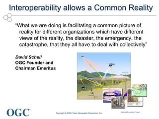
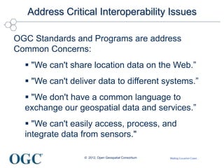
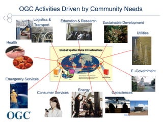
ISPRS and OGC
A partnership for advancing
geospatial information
George Percivall
OGC Chief Architect
percivall@opengeospatial.org
© 2012, Open Geospatial Consortium
Making Location Count...
Copyright © 2009, Open Geospatial Consortium, Inc.,
Interoperability allows a Common Reality
“What we are doing is facilitating a common picture of
reality for different organizations which have different
views of the reality, the disaster, the emergency, the
catastrophe, that they all have to deal with collectively”
David Schell
OGC Founder and
Chairman Emeritus
Making Location Count...
Address Critical Interoperability Issues
OGC Standards and Programs are address
Common Concerns:
 "We can't share location data on the Web.”
 "We can't deliver data to different systems.”
ď‚§ "We don't have a common language to
exchange our geospatial data and services.”
ď‚§ "We can't easily access, process, and
integrate data from sensors."
© 2012, Open Geospatial Consortium
Making Location Count...
OGC Activities Driven by Community Needs
Health
Education & Research Sustainable Development
Energy
Consumer Services Geosciences
Emergency Services
E -Government
Utilities
Logistics &
Transport
Making Location Count...
OGC Snapshot
• A Voluntary Consensus
Standards Organization,
founded in 1994.
• 467 members
• 38 adopted standards
• Hundreds of product
implementations
• Broad user community
implementation worldwide
• Alliance partnerships with 30+
standards & professional orgs
© 2012, Open Geospatial
Consortium.
OGC Membership Distribution
43%
18%
24%
6%
9%
Commercial
Government
Academic
Research
Not For Profit
Making Location Count...
OGC Snapshot
• A Voluntary Consensus
Standards Organization,
founded in 1994.
• 464 members
• 38 adopted standards
• Hundreds of product
implementations
• Broad user community
implementation worldwide
• Alliance partnerships with 30+
standards & professional orgs
© 2012, Open Geospatial
Consortium
OGC Membership Distribution
207
173
68
8
5 3
Europe
N. America
Asia / Pacific
Middle East
Africa
S. America
Making Location Count...
OGC’s Approach for Advancing Interoperability
• Interoperability Program – Rapid prototyping
that unites users, research and industry in
accelerated specification development and market
uptake
• Standards Program – Consensus standards
process similar to other Industry consortia
(World Wide Web Consortium, OMA etc.)
• Marketing and Communications Program –
education and training, encourage take up of OGC
specifications, business development, communications
• Compliance Program - allows organizations
to test their implementations of OGC Standards
with the mandatory elements of that standard
Rapid Interface
Development
Standards
Setting
Market
Adoption
Testing &
Certification
© 2012, Open Geospatial Consortium
Making Location Count...
http://www.opengeospatial.org/resource/products
700+ implementing and certified products
© 2012, Open Geospatial Consortium
Making Location Count...
© 2011 Open Geospatial Consortium
OGC Web Services (OWS)
Web Map Service (WMS)
Web Map Tile Service (WMTS)
Web Feature Service (WFS)
Web Coverage Service (WCS)
Catalogue (CSW)
Geography Markup Language (GML)
KML
Others…
Just as http:// is the dial tone of the World Wide Web, the geospatial web is
enabled by OGC standards:
Relevant to geospatial information applications: Critical Infrastructure, Emergency
Management, Weather, Climate, Homeland Security, Defense & Intelligence, Oceans
Science, others
Web Map
Server
Web Coverage
Server
Web Feature
Server
Making Location Count...
© 2012, Open Geospatial Consortium
OGC Sensor Web Enablement Standards
Discovery and tasking of sensor assets, and the access and application
of sensor observations for enhanced situational awareness
• Sensor Model Language
• Observations & Measurements
• Sensor Observation Service (SOS)
• Sensor Planning Service (SPS)
• Sensor Alert Service (SAS)
• Catalogue Service/Sensors
• PUCK
Making Location Count...
Geospatial Processing, Analysis, Workflow
Web Processing Service – WPS
• OGC Web Service access to algorithms
• Think change detection, coordinate
transformation, modeling and simulation…
© 2012, Open Geospatial Consortium
11
Geoprocessing Workflow
Making Location Count...
OGC Encoding Formats
• Geography Markup Language
– GML is also ISO 19136
– Point Profile
– Simple Features Profile
– GeoShape in IETF
– GML in JPEG2000
– GeoRSS: GML
• GML Applications
– FGDC Framework
– INSPIRE
– Climate Sci Modelling Language
– CleanSeaNet
– TDWG Biodiversity GML
– GeoSciML
– MarineXML
– Ground Water Model Language
• CityGML
• IndoorGML (in process)
• WaterML 2
• NetCDF
• CF-NetCDF (in process)
• KML
• Style Layer Descriptor
• Open GeoSMS
• ARML 2 (in process)
• SensorML
• SWE Common
• Observations and Measurements
• GeoSPARQL
• GeoXACML
• WKT and WKB
© 2012, Open Geospatial Consortium
12
Making Location Count...
CityGML - 3D Urban Models
Source; Thomas Kolbe, Berlin TU
• Urban Planning / Operations
• Emergency Mgt / Response
• Transportation / Routing / Logistics
• Indoor navigation
• Retail Site analysis
• Sustainable / Green Communities
• City Services Management
• Noise abatement
• Telecommunications placement
• Many other uses…
© 2012, Open Geospatial Consortium
www.3d-stadtmodell-berlin.de
Making Location Count...
GeoData Fusion
© 2012 Open Geospatial Consortium, Inc.
14
Fusion: “Process of combining data and information to improve
detection, identification, and characterization of entities”
OGC Fusion Standards Study, Phase 2 Engineering Report, OGC Document 10-184 2010-12-13
http://portal.opengeospatial.org/files/?artifact_id=41573
Making Location Count...
More OGC Areas of Focus
© 2011, Open Geospatial Consortium
Making Location Count...
ISPRS and OGC Partnership
• Geospatial technologies and markets continue to evolve in
an increasingly complex world
• ISPRS is devoted to advancement of photogrammetry and
remote sensing and their applications.
• OGC is dedicated to developing and promoting the use of
geospatial best practices, standards and interoperability
• OGC and ISPRS work jointly in order that research on
photogrammetric and remote sensing informs development
of open interoperability standards for global benefit.
© 2012, Open Geospatial Consortium
16
Making Location Count...
Current and potential topics of
ISPRS/OGC joint activity
Technical Topics
• 3D data and visualization,
e.g., CityGML, IndoorGML
• Web Services for remote
sensed data
• Sensor Web
• Fusion: observations,
features, decision
Program Topics
• ISPRS Journal – OGC
Special Issue
• ISPRS in the OGC
Interoperability Program
• GEOSS
• Business Value of Open
Access to Spatial Data
• Developing Countries
© 2012, Open Geospatial Consortium
17
Making Location Count...
Why OGC Standards?
User Perspective
• Rapidly mobilize new
capabilities
• Lower system lifecycle costs
• Encourage market competition
• Choose solutions based on
functionality desired
• Avoid “lock in” to a proprietary
architecture
• Decision to share information
and services becomes a
• decision
“What OGC brings to
the table is…everyone
has confidence we
won’t take advantage of
the format or change it
in a way that will harm
anyone”
Michael Weiss-Malik,
Google KML product
manager
© 2012, Open Geospatial Consortium
Making Location Count...
DigitalGlobe on Standards and OGC
“Standards-based interoperability is key for improved timeliness for
delivering relevant imagery to our users. It just works.”
“These well defined standards enable quick integration into existing and
custom workflows and allow mashups with many types of other OGC-
delivered geospatial content.
“We deliver FirstLook imagery to the UN entirely via OGC-based
services (e.g. WMS, WMTS, WFS, KML)
“In addition to providing imagery to end users, we also work with
partners and other vendors to extend valuable geospatial content into
their products using OGC services…”
John Lucier, Senior Manager, DigitalGlobe
Making Location Count...
Interoperability is about Organizations
“Interoperability seems to be about the
integration of information.
What it’s really about is the coordination of
organizational behavior.”
David Schell
OGC Founder and
Chairman Emeritus
Making Location Count...
OGC ANZ Forum
• Chartered June 2012
• 28 Members
• Govt, Research, Private Sector
• Highlights value of open
standards
• Environment that fosters
collaboration and sharing
• Education and awareness
• Work towards greater
interoperability
• Contact
denise.mckenzie@dse.vic.gov.au.
CURRENT MEMBERSHIP
1Spatial
Australian Bureau of Meteorology
Australian Bureau of Statistics
Australian Department of Defence
Australian Ocean Data Centre Joint Facility
CSIRO
Department of Natural Resources and Mines (QLD)
Department of Primary Industries (VIC)
Department of Sustainability and Environment (VIC)
Gaia Resources
Geoscience Australia
Gosford City Council (NSW)
Google
Intergraph
La Trobe University
Land and Property Info Div, Dept. of Finance and Services (NSW)
Land Information New Zealand (LINZ)
Landcare Research New Zealand Ltd
Landgate (WA)
Lisasoft Pty Ltd
Mercury Project Solutions
National Institute of Water and Atmospheric Research (NZ)
Office of Spatial Policy (OSP), Department of Resources, Energy & Tourism
PSMA Australia Ltd
Robert Starling
Sigma Bravo
Sparx Systems
University of Melbourne
Making Location Count...
For Details on OGC Standards…
• OGC Standards
– Freely available
– www.opengeospatial.org/standards
– Anyone can post a change request
• OGC Reference Model (ORM)
– Overview of OGC Standards Baseline
– Resource for defining architectures for specific
applications
– www.opengeospatial.org/standards/orm
George Percivall, gpercivall at opengeospatial.org

OGC standards relevant to ISPRS

  • 1.
    ISPRS and OGC Apartnership for advancing geospatial information George Percivall OGC Chief Architect percivall@opengeospatial.org © 2012, Open Geospatial Consortium
  • 2.
    Making Location Count... Copyright© 2009, Open Geospatial Consortium, Inc., Interoperability allows a Common Reality “What we are doing is facilitating a common picture of reality for different organizations which have different views of the reality, the disaster, the emergency, the catastrophe, that they all have to deal with collectively” David Schell OGC Founder and Chairman Emeritus
  • 3.
    Making Location Count... AddressCritical Interoperability Issues OGC Standards and Programs are address Common Concerns:  "We can't share location data on the Web.”  "We can't deliver data to different systems.”  "We don't have a common language to exchange our geospatial data and services.”  "We can't easily access, process, and integrate data from sensors." © 2012, Open Geospatial Consortium
  • 4.
    Making Location Count... OGCActivities Driven by Community Needs Health Education & Research Sustainable Development Energy Consumer Services Geosciences Emergency Services E -Government Utilities Logistics & Transport
  • 5.
    Making Location Count... OGCSnapshot • A Voluntary Consensus Standards Organization, founded in 1994. • 467 members • 38 adopted standards • Hundreds of product implementations • Broad user community implementation worldwide • Alliance partnerships with 30+ standards & professional orgs © 2012, Open Geospatial Consortium. OGC Membership Distribution 43% 18% 24% 6% 9% Commercial Government Academic Research Not For Profit
  • 6.
    Making Location Count... OGCSnapshot • A Voluntary Consensus Standards Organization, founded in 1994. • 464 members • 38 adopted standards • Hundreds of product implementations • Broad user community implementation worldwide • Alliance partnerships with 30+ standards & professional orgs © 2012, Open Geospatial Consortium OGC Membership Distribution 207 173 68 8 5 3 Europe N. America Asia / Pacific Middle East Africa S. America
  • 7.
    Making Location Count... OGC’sApproach for Advancing Interoperability • Interoperability Program – Rapid prototyping that unites users, research and industry in accelerated specification development and market uptake • Standards Program – Consensus standards process similar to other Industry consortia (World Wide Web Consortium, OMA etc.) • Marketing and Communications Program – education and training, encourage take up of OGC specifications, business development, communications • Compliance Program - allows organizations to test their implementations of OGC Standards with the mandatory elements of that standard Rapid Interface Development Standards Setting Market Adoption Testing & Certification © 2012, Open Geospatial Consortium
  • 8.
    Making Location Count... http://www.opengeospatial.org/resource/products 700+implementing and certified products © 2012, Open Geospatial Consortium
  • 9.
    Making Location Count... ©2011 Open Geospatial Consortium OGC Web Services (OWS) Web Map Service (WMS) Web Map Tile Service (WMTS) Web Feature Service (WFS) Web Coverage Service (WCS) Catalogue (CSW) Geography Markup Language (GML) KML Others… Just as http:// is the dial tone of the World Wide Web, the geospatial web is enabled by OGC standards: Relevant to geospatial information applications: Critical Infrastructure, Emergency Management, Weather, Climate, Homeland Security, Defense & Intelligence, Oceans Science, others Web Map Server Web Coverage Server Web Feature Server
  • 10.
    Making Location Count... ©2012, Open Geospatial Consortium OGC Sensor Web Enablement Standards Discovery and tasking of sensor assets, and the access and application of sensor observations for enhanced situational awareness • Sensor Model Language • Observations & Measurements • Sensor Observation Service (SOS) • Sensor Planning Service (SPS) • Sensor Alert Service (SAS) • Catalogue Service/Sensors • PUCK
  • 11.
    Making Location Count... GeospatialProcessing, Analysis, Workflow Web Processing Service – WPS • OGC Web Service access to algorithms • Think change detection, coordinate transformation, modeling and simulation… © 2012, Open Geospatial Consortium 11 Geoprocessing Workflow
  • 12.
    Making Location Count... OGCEncoding Formats • Geography Markup Language – GML is also ISO 19136 – Point Profile – Simple Features Profile – GeoShape in IETF – GML in JPEG2000 – GeoRSS: GML • GML Applications – FGDC Framework – INSPIRE – Climate Sci Modelling Language – CleanSeaNet – TDWG Biodiversity GML – GeoSciML – MarineXML – Ground Water Model Language • CityGML • IndoorGML (in process) • WaterML 2 • NetCDF • CF-NetCDF (in process) • KML • Style Layer Descriptor • Open GeoSMS • ARML 2 (in process) • SensorML • SWE Common • Observations and Measurements • GeoSPARQL • GeoXACML • WKT and WKB © 2012, Open Geospatial Consortium 12
  • 13.
    Making Location Count... CityGML- 3D Urban Models Source; Thomas Kolbe, Berlin TU • Urban Planning / Operations • Emergency Mgt / Response • Transportation / Routing / Logistics • Indoor navigation • Retail Site analysis • Sustainable / Green Communities • City Services Management • Noise abatement • Telecommunications placement • Many other uses… © 2012, Open Geospatial Consortium www.3d-stadtmodell-berlin.de
  • 14.
    Making Location Count... GeoDataFusion © 2012 Open Geospatial Consortium, Inc. 14 Fusion: “Process of combining data and information to improve detection, identification, and characterization of entities” OGC Fusion Standards Study, Phase 2 Engineering Report, OGC Document 10-184 2010-12-13 http://portal.opengeospatial.org/files/?artifact_id=41573
  • 15.
    Making Location Count... MoreOGC Areas of Focus © 2011, Open Geospatial Consortium
  • 16.
    Making Location Count... ISPRSand OGC Partnership • Geospatial technologies and markets continue to evolve in an increasingly complex world • ISPRS is devoted to advancement of photogrammetry and remote sensing and their applications. • OGC is dedicated to developing and promoting the use of geospatial best practices, standards and interoperability • OGC and ISPRS work jointly in order that research on photogrammetric and remote sensing informs development of open interoperability standards for global benefit. © 2012, Open Geospatial Consortium 16
  • 17.
    Making Location Count... Currentand potential topics of ISPRS/OGC joint activity Technical Topics • 3D data and visualization, e.g., CityGML, IndoorGML • Web Services for remote sensed data • Sensor Web • Fusion: observations, features, decision Program Topics • ISPRS Journal – OGC Special Issue • ISPRS in the OGC Interoperability Program • GEOSS • Business Value of Open Access to Spatial Data • Developing Countries © 2012, Open Geospatial Consortium 17
  • 18.
    Making Location Count... WhyOGC Standards? User Perspective • Rapidly mobilize new capabilities • Lower system lifecycle costs • Encourage market competition • Choose solutions based on functionality desired • Avoid “lock in” to a proprietary architecture • Decision to share information and services becomes a • decision “What OGC brings to the table is…everyone has confidence we won’t take advantage of the format or change it in a way that will harm anyone” Michael Weiss-Malik, Google KML product manager © 2012, Open Geospatial Consortium
  • 19.
    Making Location Count... DigitalGlobeon Standards and OGC “Standards-based interoperability is key for improved timeliness for delivering relevant imagery to our users. It just works.” “These well defined standards enable quick integration into existing and custom workflows and allow mashups with many types of other OGC- delivered geospatial content. “We deliver FirstLook imagery to the UN entirely via OGC-based services (e.g. WMS, WMTS, WFS, KML) “In addition to providing imagery to end users, we also work with partners and other vendors to extend valuable geospatial content into their products using OGC services…” John Lucier, Senior Manager, DigitalGlobe
  • 20.
    Making Location Count... Interoperabilityis about Organizations “Interoperability seems to be about the integration of information. What it’s really about is the coordination of organizational behavior.” David Schell OGC Founder and Chairman Emeritus
  • 21.
    Making Location Count... OGCANZ Forum • Chartered June 2012 • 28 Members • Govt, Research, Private Sector • Highlights value of open standards • Environment that fosters collaboration and sharing • Education and awareness • Work towards greater interoperability • Contact denise.mckenzie@dse.vic.gov.au. CURRENT MEMBERSHIP 1Spatial Australian Bureau of Meteorology Australian Bureau of Statistics Australian Department of Defence Australian Ocean Data Centre Joint Facility CSIRO Department of Natural Resources and Mines (QLD) Department of Primary Industries (VIC) Department of Sustainability and Environment (VIC) Gaia Resources Geoscience Australia Gosford City Council (NSW) Google Intergraph La Trobe University Land and Property Info Div, Dept. of Finance and Services (NSW) Land Information New Zealand (LINZ) Landcare Research New Zealand Ltd Landgate (WA) Lisasoft Pty Ltd Mercury Project Solutions National Institute of Water and Atmospheric Research (NZ) Office of Spatial Policy (OSP), Department of Resources, Energy & Tourism PSMA Australia Ltd Robert Starling Sigma Bravo Sparx Systems University of Melbourne
  • 22.
    Making Location Count... ForDetails on OGC Standards… • OGC Standards – Freely available – www.opengeospatial.org/standards – Anyone can post a change request • OGC Reference Model (ORM) – Overview of OGC Standards Baseline – Resource for defining architectures for specific applications – www.opengeospatial.org/standards/orm George Percivall, gpercivall at opengeospatial.org

Editor's Notes

  • #11 Quicklydiscover sensors (secure or public) that can meet my needs – and learn about what they can do (location, observables, quality, ability to task)Obtain sensor information in a standard encoding that is understandable by the user and by softwareReadily access sensor observations in a common manner, and in a form specific to my needsTask sensors, when possible, to meet my specific needsRequest and receive alerts / notification when a sensor measures a particular phenomenon, or completes a requested taskInformation Models and SchemaSensor Model Language (SensorML) for In-situ and Remote Sensors - Core models and schema for observation processes: support for sensor components, georegistration, response models, post measurement processingObservations and Measurements (O&M) – Core models and schema for observationsTransducerML – adds system integration and real-time streaming clusters of observationsWeb ServicesSensor Observation Service - Access Observations for a sensor or sensor constellation, and optionally, the associated sensor and platform dataSensor Alert Service – Subscribe to alerts based upon sensor observationsSensor Planning Service – Request collection feasibility and task sensor system for desired observationsWeb Notification Service –Manage message dialogue between client and Web service(s) for long duration (asynchronous) processesSensor Registries – Discover sensors and sensor observations