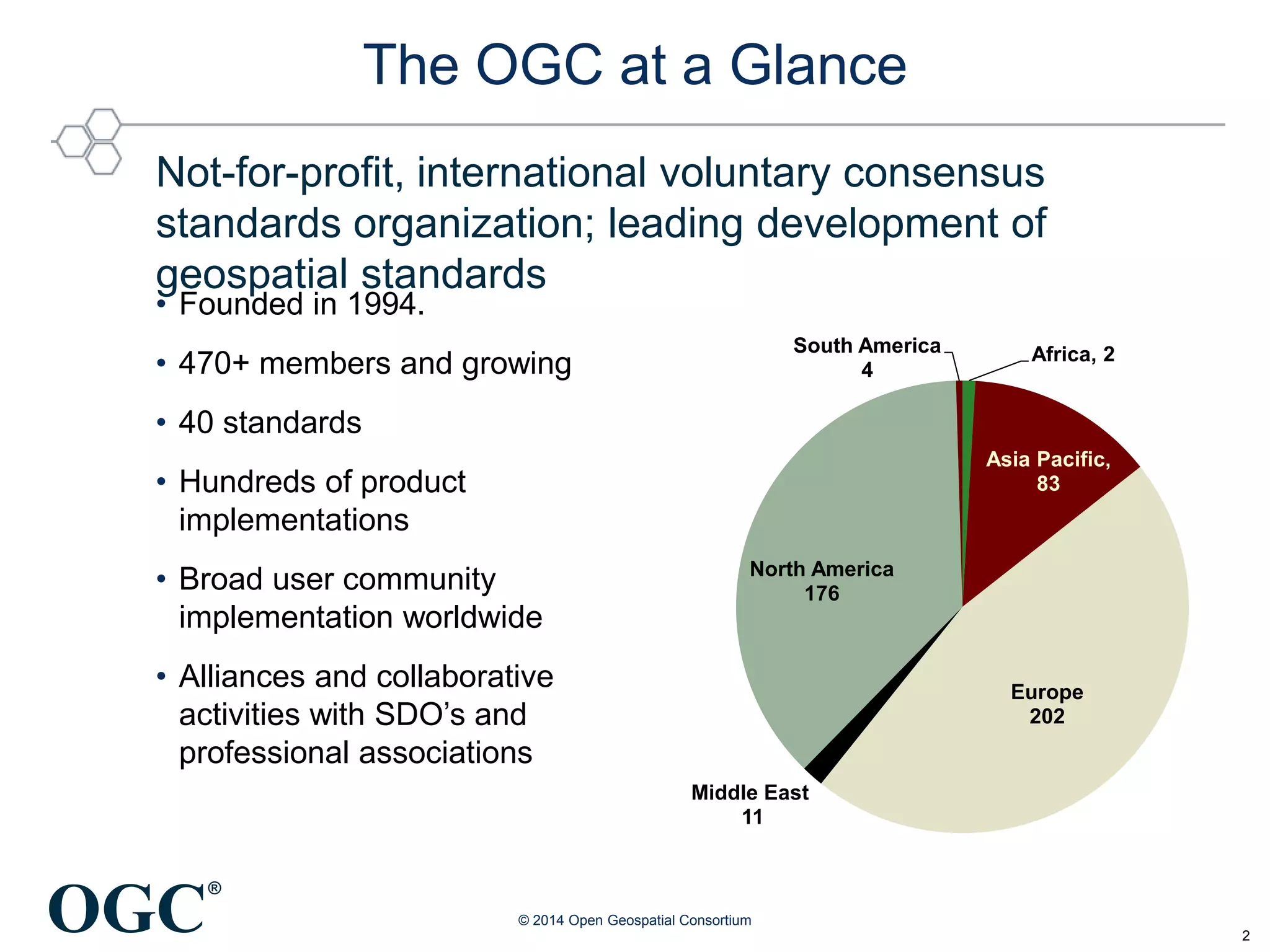
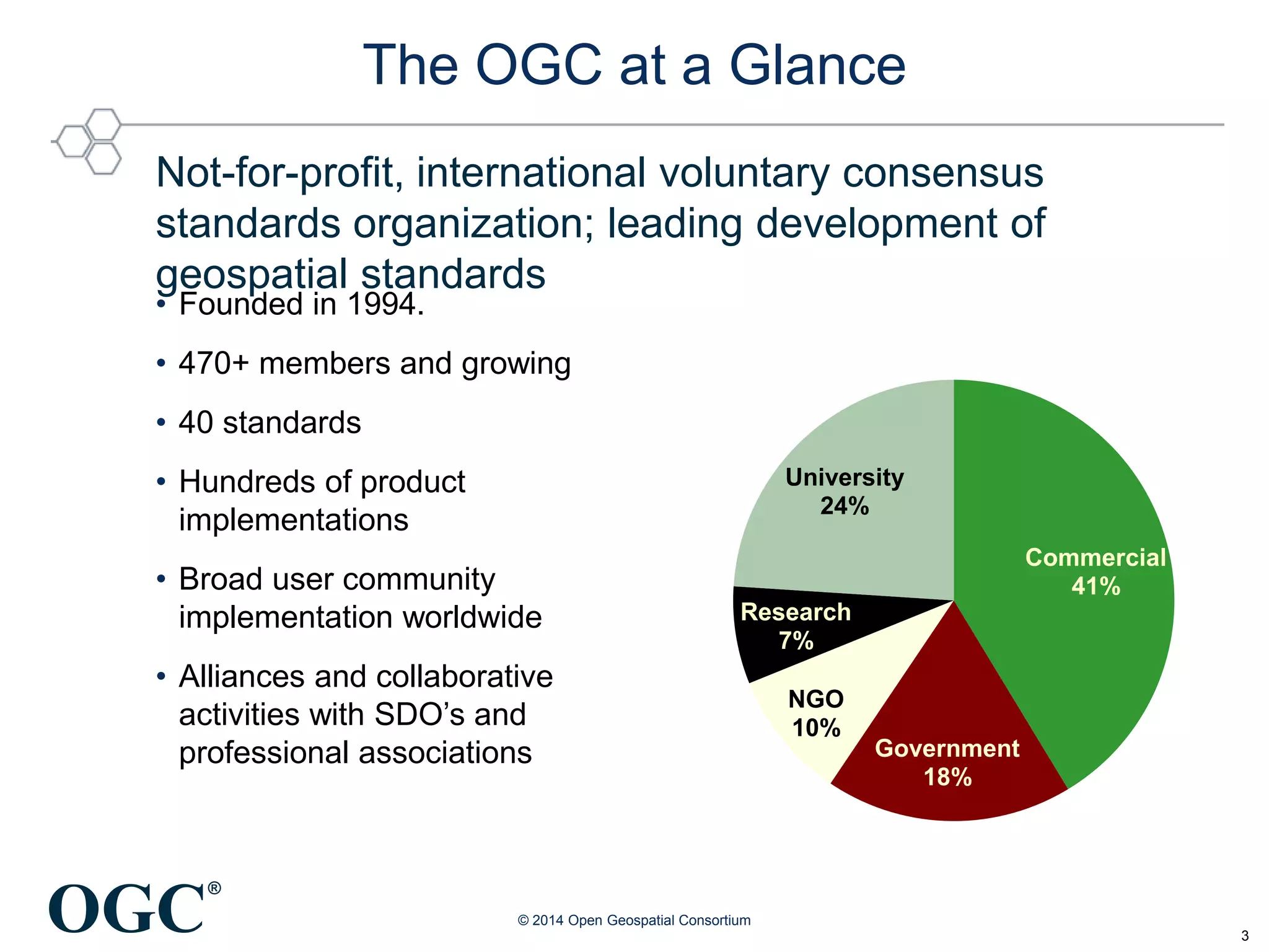
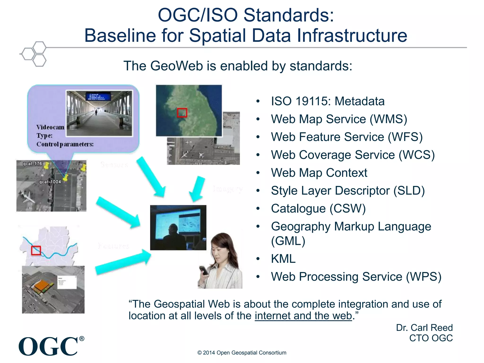
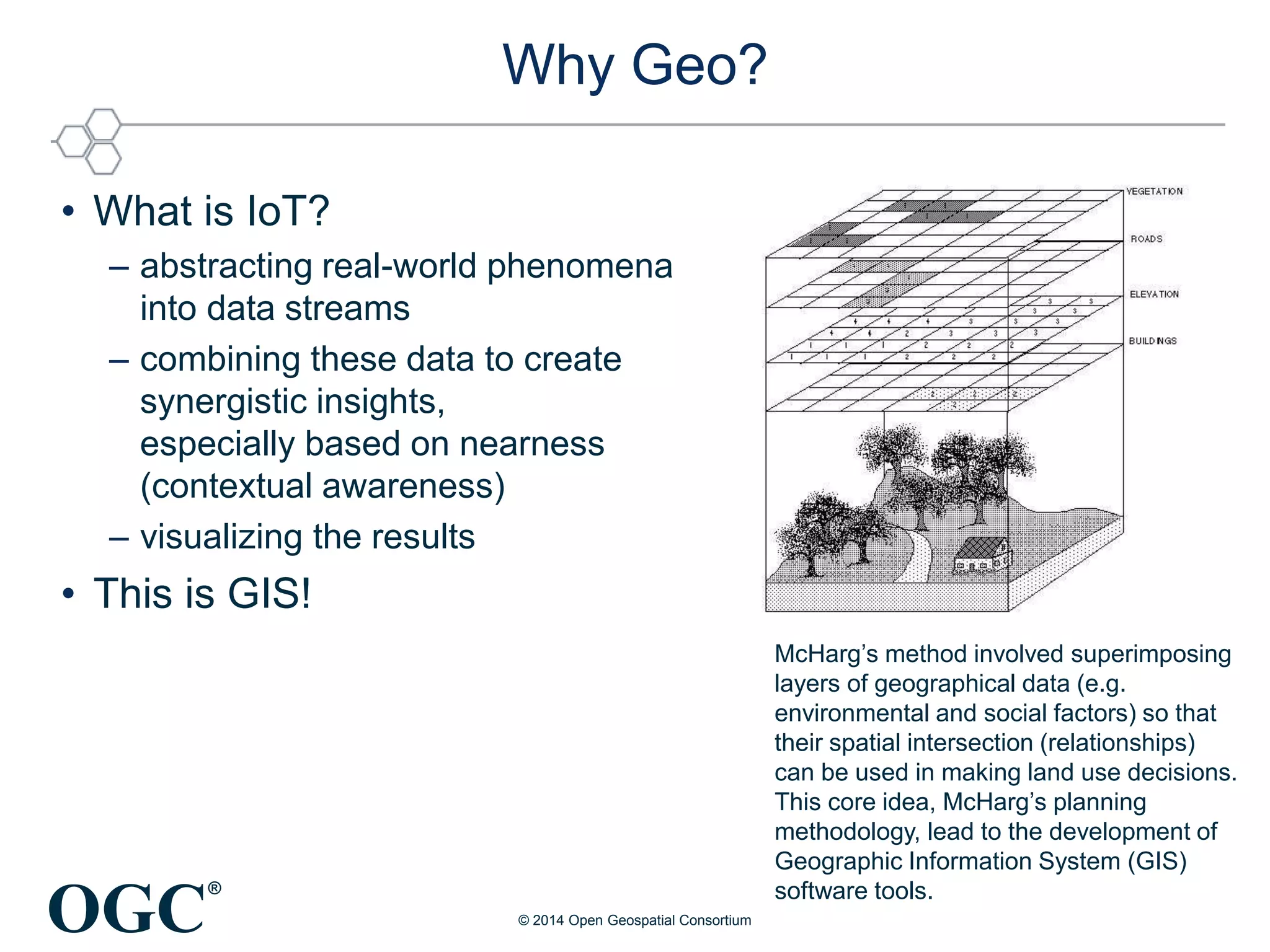
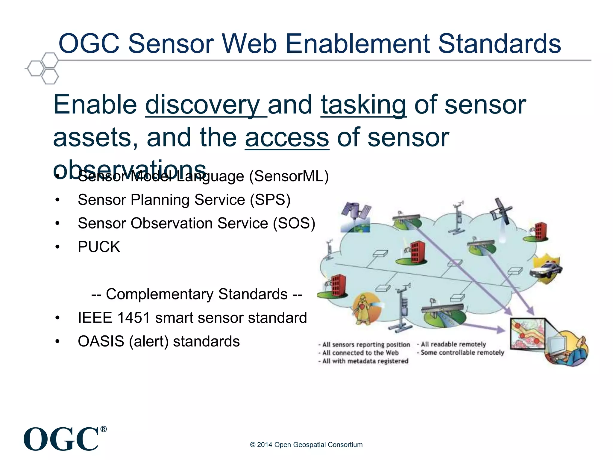
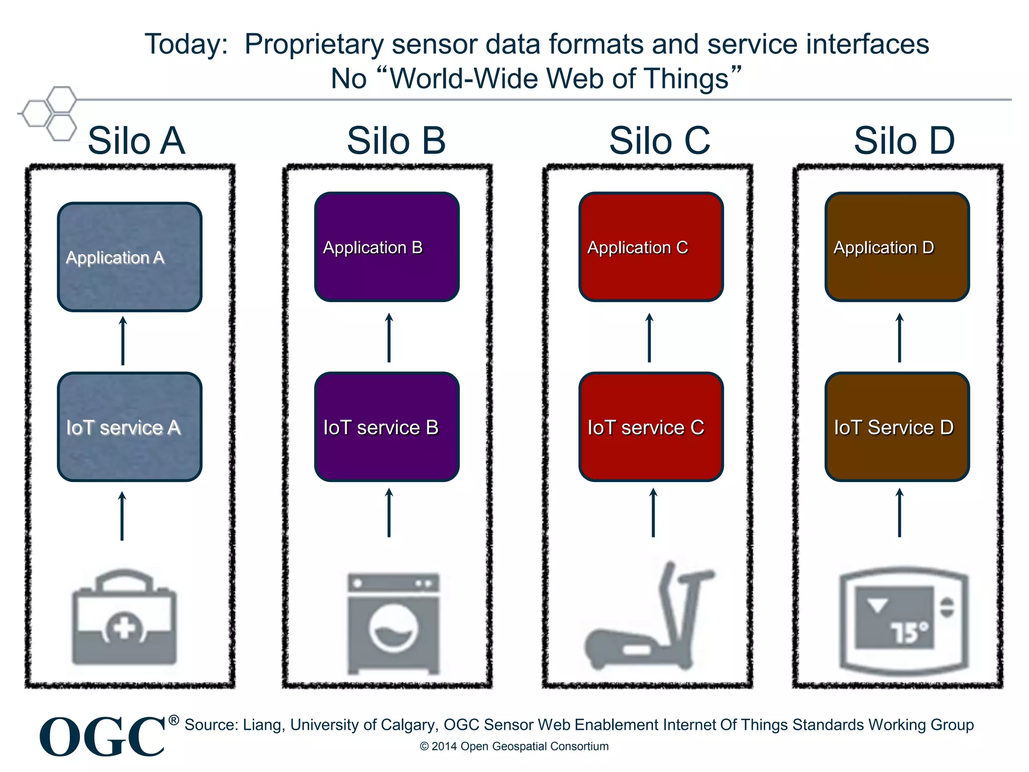
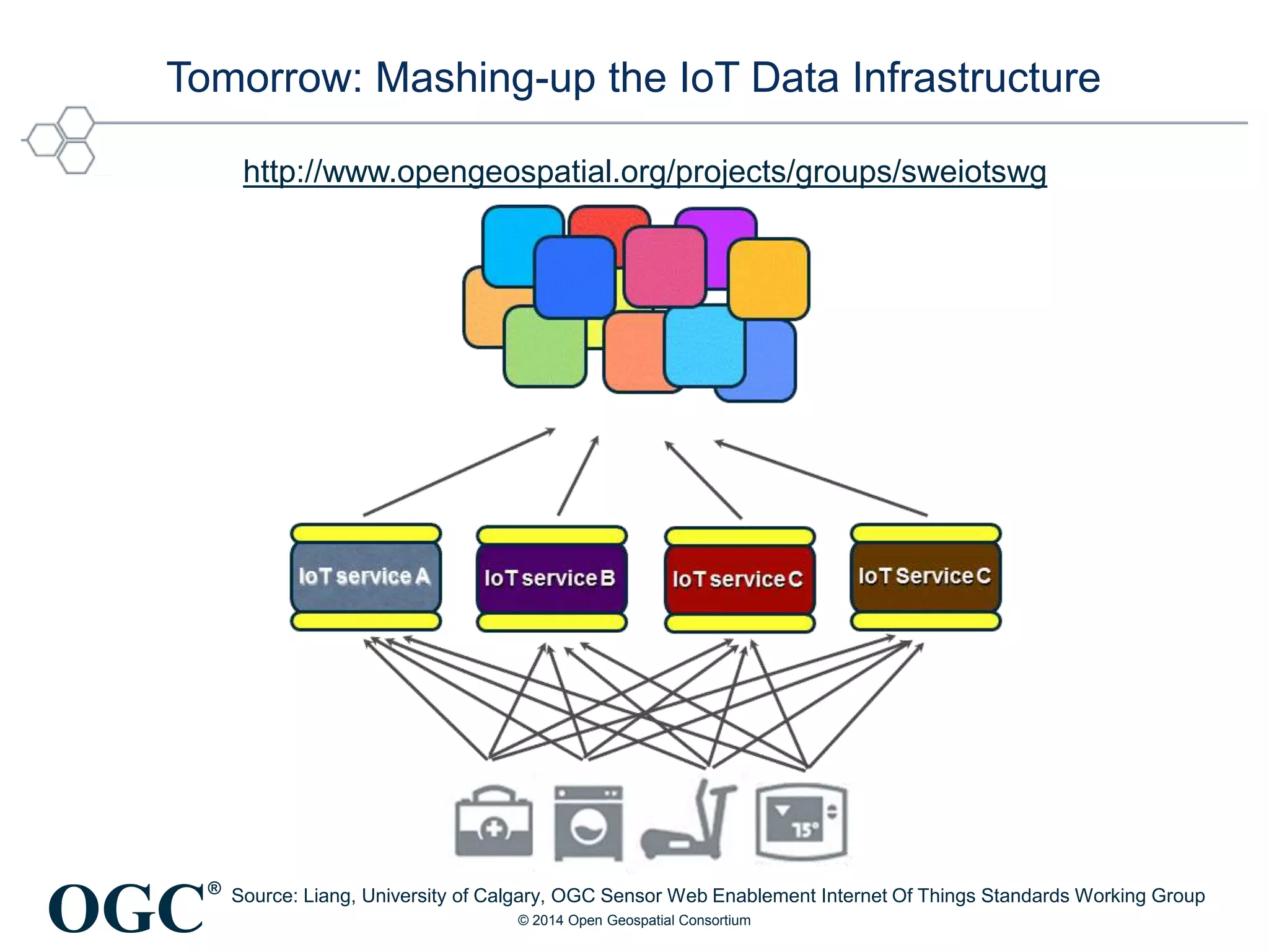
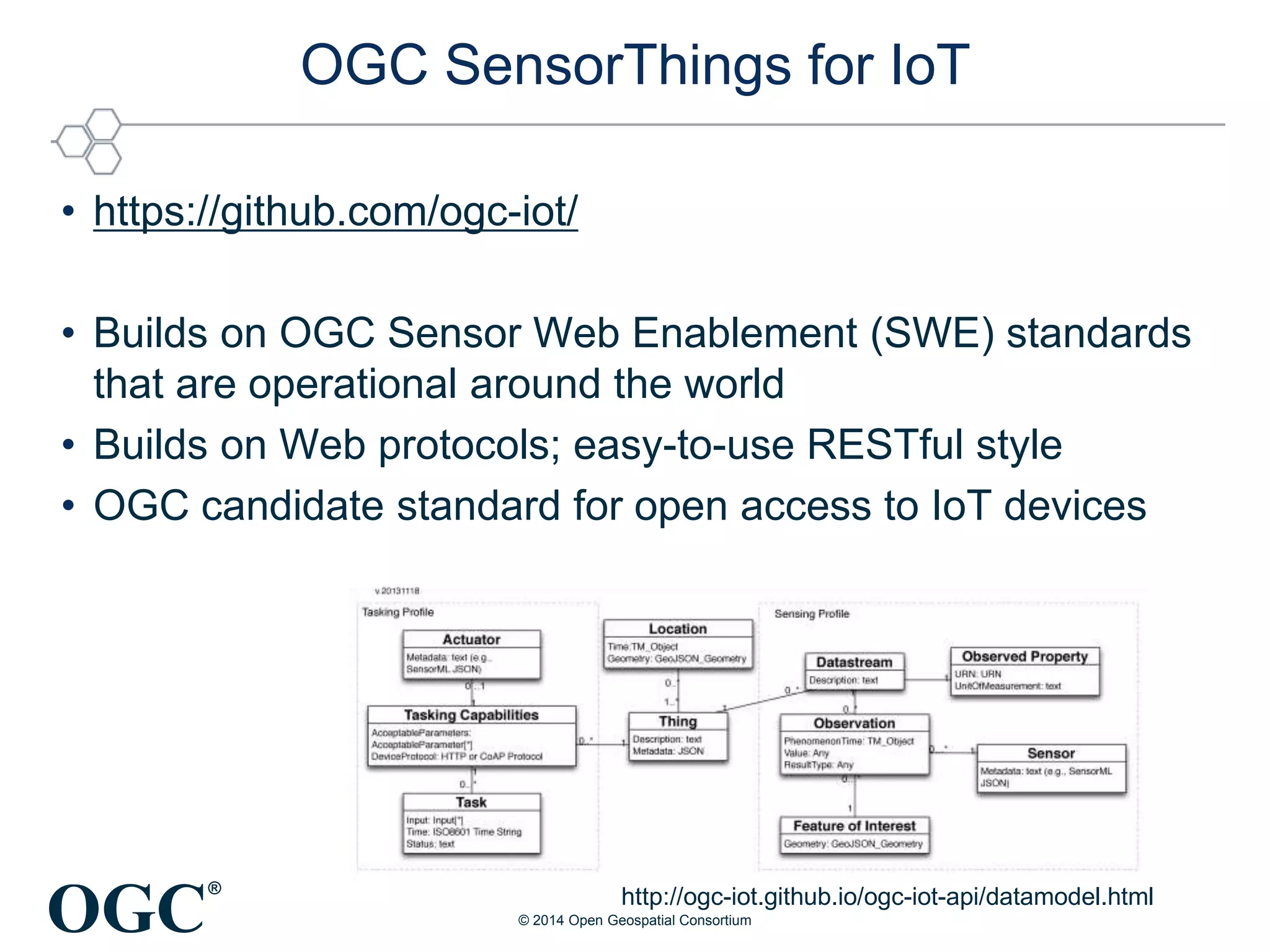
SlideShare a Scribd company logo
®
IoT Meets Geospatial
Geoweb Summit #8
Raj Singh
Open Geospatial Consortium
May 22, 2014
© 2014 Open Geospatial Consortium
OGC
®
2
The OGC at a Glance
Not-for-profit, international voluntary consensus
standards organization; leading development of
geospatial standards
© 2014 Open Geospatial Consortium
• Founded in 1994.
• 470+ members and growing
• 40 standards
• Hundreds of product
implementations
• Broad user community
implementation worldwide
• Alliances and collaborative
activities with SDO’s and
professional associations
Africa, 2
Asia Pacific,
83
Europe
202
Middle East
11
North America
176
South America
4
OGC
®
Commercial
41%
Government
18%
NGO
10%
Research
7%
University
24%
3
The OGC at a Glance
Not-for-profit, international voluntary consensus
standards organization; leading development of
geospatial standards
© 2014 Open Geospatial Consortium
• Founded in 1994.
• 470+ members and growing
• 40 standards
• Hundreds of product
implementations
• Broad user community
implementation worldwide
• Alliances and collaborative
activities with SDO’s and
professional associations
OGC
®
OGC/ISO Standards:
Baseline for Spatial Data Infrastructure
• ISO 19115: Metadata
• Web Map Service (WMS)
• Web Feature Service (WFS)
• Web Coverage Service (WCS)
• Web Map Context
• Style Layer Descriptor (SLD)
• Catalogue (CSW)
• Geography Markup Language
(GML)
• KML
• Web Processing Service (WPS)
The GeoWeb is enabled by standards:
“The Geospatial Web is about the complete integration and use of
location at all levels of the internet and the web.”
Dr. Carl Reed
CTO OGC
© 2014 Open Geospatial Consortium
OGC
®
Why Geo?
• What is IoT?
– abstracting real-world phenomena
into data streams
– combining these data to create
synergistic insights,
especially based on nearness
(contextual awareness)
– visualizing the results
• This is GIS!
© 2014 Open Geospatial Consortium
McHarg’s method involved superimposing
layers of geographical data (e.g.
environmental and social factors) so that
their spatial intersection (relationships)
can be used in making land use decisions.
This core idea, McHarg’s planning
methodology, lead to the development of
Geographic Information System (GIS)
software tools.
OGC
®
IoT is finally arriving:
it’s bubbling up from the grassroots.
• IoT: long-prophesied phenomenon of everyday devices
talking to one another — and us — online
– Back in the ’90s, big companies built systems to do tricks like this, but they
were expensive, hard to use, and vendor-specific.
• Hackers now using increasingly inexpensive sensors and
open source hardware, add intelligence to ordinary objects.
– Sensor prices going down; sizes going down. Only limit is your imagination.
– Cloud services – “If This Then That” or Cosm - let devices interact in
unexpected ways
• IoT has reached the “Apple II stage”
– when a new technology finally becomes easy enough to use that
thousands of people start using it.
http://www.wired.com/opinion/2012/12/20-12-st_thompson/
© 2014 Open Geospatial Consortium
OGC
®
OGC Sensor Web Enablement Standards
Enable discovery and tasking of sensor
assets, and the access of sensor
observations• Sensor Model Language (SensorML)
• Sensor Planning Service (SPS)
• Sensor Observation Service (SOS)
• PUCK
-- Complementary Standards --
• IEEE 1451 smart sensor standard
• OASIS (alert) standards
© 2014 Open Geospatial Consortium
OGC
®
Large-scale Opportunistic Sensing
• Smartphones to be pocket seismometers
– Right now, can detect earthquakes above Magnitude 5.0. With
better accelerometers in smartphones hope to detect smaller ones
– precious seconds' advance notice that a big trembler is on its way
• pressureNET
– Global network of user-contributed atmospheric pressure readings.
– App displays data as markers on map and graphed over time
– To improve weather forecasting models.
• IoT devices measure Air quality (CO, NO2)
– AirCasting - Air Quality Egg
http://www.bbc.co.uk/news/science-environment-20531304
http://www.aircasting.org/
http://pndv.cumulonimbus.ca
© 2014 Open Geospatial Consortium
OGC
®
IoT service A IoT service B IoT service C IoT Service D
Application A
Application B Application C Application D
Silo A Silo B Silo C Silo D
Today: Proprietary sensor data formats and service interfaces
No “World-Wide Web of Things”
Source: Liang, University of Calgary, OGC Sensor Web Enablement Internet Of Things Standards Working Group
© 2014 Open Geospatial Consortium
OGC
®
Tomorrow: Mashing-up the IoT Data Infrastructure
Source: Liang, University of Calgary, OGC Sensor Web Enablement Internet Of Things Standards Working Group
http://www.opengeospatial.org/projects/groups/sweiotswg
© 2014 Open Geospatial Consortium
OGC
®
OGC SensorThings for IoT
• https://github.com/ogc-iot/
• Builds on OGC Sensor Web Enablement (SWE) standards
that are operational around the world
• Builds on Web protocols; easy-to-use RESTful style
• OGC candidate standard for open access to IoT devices
http://ogc-iot.github.io/ogc-iot-api/datamodel.html
© 2014 Open Geospatial Consortium

More Related Content

What's hot

CyberGIS Architectures for Collaborative Problem Solving - OGC perspective
CyberGIS Architectures for Collaborative Problem Solving - OGC perspectiveCyberGIS Architectures for Collaborative Problem Solving - OGC perspective
CyberGIS Architectures for Collaborative Problem Solving - OGC perspective
George Percivall
 
The power of location information for mobile
The power of location information for mobileThe power of location information for mobile
The power of location information for mobile
George Percivall
 
OGC SensorThings API for Location Aware Sensing System (LASS) 2017 User Confe...
OGC SensorThings API for Location Aware Sensing System (LASS) 2017 User Confe...OGC SensorThings API for Location Aware Sensing System (LASS) 2017 User Confe...
OGC SensorThings API for Location Aware Sensing System (LASS) 2017 User Confe...
SensorUp
 
Spatial Computing and the Future of Utility GIS
Spatial Computing and the Future of Utility GISSpatial Computing and the Future of Utility GIS
Spatial Computing and the Future of Utility GIS
George Percivall
 
Open Standard Internet of Things for Smart Cities
Open Standard Internet of Things for Smart CitiesOpen Standard Internet of Things for Smart Cities
Open Standard Internet of Things for Smart Cities
SensorUp
 
Evolution of System Architectures: Where Do We Need to Fail Next?
Evolution of System Architectures: Where Do We Need to Fail Next?Evolution of System Architectures: Where Do We Need to Fail Next?
Evolution of System Architectures: Where Do We Need to Fail Next?
Luis Bermudez
 
OGC SensorThings API - a very short introduction for ITU-T
OGC SensorThings API - a very short introduction for ITU-TOGC SensorThings API - a very short introduction for ITU-T
OGC SensorThings API - a very short introduction for ITU-T
SensorUp
 
Actionable Insights from Multi-sensor IoT Systems using the OGC SensorThings ...
Actionable Insights from Multi-sensor IoT Systems using the OGC SensorThings ...Actionable Insights from Multi-sensor IoT Systems using the OGC SensorThings ...
Actionable Insights from Multi-sensor IoT Systems using the OGC SensorThings ...
SensorUp
 
Discussion materials for the Internet of Things and Blockchain
Discussion materials for the Internet of Things and BlockchainDiscussion materials for the Internet of Things and Blockchain
Discussion materials for the Internet of Things and Blockchain
SensorUp
 
Edge Computing and OGC SensorThings API
Edge Computing and OGC SensorThings APIEdge Computing and OGC SensorThings API
Edge Computing and OGC SensorThings API
SensorUp
 
Introduction to Open Source GIS
Introduction to Open Source GISIntroduction to Open Source GIS
Introduction to Open Source GIS
SANGHEE SHIN
 
Geology, Apps, Maps & Augmented Reality (Patrick Bell, BGS)
Geology, Apps, Maps & Augmented Reality  (Patrick Bell, BGS)Geology, Apps, Maps & Augmented Reality  (Patrick Bell, BGS)
Geology, Apps, Maps & Augmented Reality (Patrick Bell, BGS)
Association for Geographic Information (AGI)
 
Arctic Web Map, PolarMap.js, Arctic Sensor Web, and Arctic Citizen Sensors
Arctic Web Map, PolarMap.js, Arctic Sensor Web, and Arctic Citizen SensorsArctic Web Map, PolarMap.js, Arctic Sensor Web, and Arctic Citizen Sensors
Arctic Web Map, PolarMap.js, Arctic Sensor Web, and Arctic Citizen Sensors
SensorUp
 
Introduction of Open Source GIS
Introduction of Open Source GISIntroduction of Open Source GIS
Introduction of Open Source GIS
SANGHEE SHIN
 
Designing a Better Planet with Big Data and Sensor Networks (for Intelligent ...
Designing a Better Planet with Big Data and Sensor Networks (for Intelligent ...Designing a Better Planet with Big Data and Sensor Networks (for Intelligent ...
Designing a Better Planet with Big Data and Sensor Networks (for Intelligent ...
Rainer Sternfeld
 
SDSC Technology Forum: Increasing the Impact of High Resolution Topography Da...
SDSC Technology Forum: Increasing the Impact of High Resolution Topography Da...SDSC Technology Forum: Increasing the Impact of High Resolution Topography Da...
SDSC Technology Forum: Increasing the Impact of High Resolution Topography Da...
OpenTopography Facility
 
Smart Citizen Workshop - Cybera Summit 2016, Banff, Canada
Smart Citizen Workshop - Cybera Summit 2016, Banff, CanadaSmart Citizen Workshop - Cybera Summit 2016, Banff, Canada
Smart Citizen Workshop - Cybera Summit 2016, Banff, Canada
SensorUp
 
OGC Interfaces in Thematic Exploitation Platforms
OGC Interfaces in Thematic Exploitation PlatformsOGC Interfaces in Thematic Exploitation Platforms
OGC Interfaces in Thematic Exploitation Platforms
terradue
 
Introduction of Open Source GIS
Introduction of Open Source GISIntroduction of Open Source GIS
Introduction of Open Source GIS
SANGHEE SHIN
 
Singapore 3D Map for a Smart Nation
Singapore 3D Map for a Smart NationSingapore 3D Map for a Smart Nation
Singapore 3D Map for a Smart Nation
Monica Moran
 

What's hot (20)

CyberGIS Architectures for Collaborative Problem Solving - OGC perspective
CyberGIS Architectures for Collaborative Problem Solving - OGC perspectiveCyberGIS Architectures for Collaborative Problem Solving - OGC perspective
CyberGIS Architectures for Collaborative Problem Solving - OGC perspective
 
The power of location information for mobile
The power of location information for mobileThe power of location information for mobile
The power of location information for mobile
 
OGC SensorThings API for Location Aware Sensing System (LASS) 2017 User Confe...
OGC SensorThings API for Location Aware Sensing System (LASS) 2017 User Confe...OGC SensorThings API for Location Aware Sensing System (LASS) 2017 User Confe...
OGC SensorThings API for Location Aware Sensing System (LASS) 2017 User Confe...
 
Spatial Computing and the Future of Utility GIS
Spatial Computing and the Future of Utility GISSpatial Computing and the Future of Utility GIS
Spatial Computing and the Future of Utility GIS
 
Open Standard Internet of Things for Smart Cities
Open Standard Internet of Things for Smart CitiesOpen Standard Internet of Things for Smart Cities
Open Standard Internet of Things for Smart Cities
 
Evolution of System Architectures: Where Do We Need to Fail Next?
Evolution of System Architectures: Where Do We Need to Fail Next?Evolution of System Architectures: Where Do We Need to Fail Next?
Evolution of System Architectures: Where Do We Need to Fail Next?
 
OGC SensorThings API - a very short introduction for ITU-T
OGC SensorThings API - a very short introduction for ITU-TOGC SensorThings API - a very short introduction for ITU-T
OGC SensorThings API - a very short introduction for ITU-T
 
Actionable Insights from Multi-sensor IoT Systems using the OGC SensorThings ...
Actionable Insights from Multi-sensor IoT Systems using the OGC SensorThings ...Actionable Insights from Multi-sensor IoT Systems using the OGC SensorThings ...
Actionable Insights from Multi-sensor IoT Systems using the OGC SensorThings ...
 
Discussion materials for the Internet of Things and Blockchain
Discussion materials for the Internet of Things and BlockchainDiscussion materials for the Internet of Things and Blockchain
Discussion materials for the Internet of Things and Blockchain
 
Edge Computing and OGC SensorThings API
Edge Computing and OGC SensorThings APIEdge Computing and OGC SensorThings API
Edge Computing and OGC SensorThings API
 
Introduction to Open Source GIS
Introduction to Open Source GISIntroduction to Open Source GIS
Introduction to Open Source GIS
 
Geology, Apps, Maps & Augmented Reality (Patrick Bell, BGS)
Geology, Apps, Maps & Augmented Reality  (Patrick Bell, BGS)Geology, Apps, Maps & Augmented Reality  (Patrick Bell, BGS)
Geology, Apps, Maps & Augmented Reality (Patrick Bell, BGS)
 
Arctic Web Map, PolarMap.js, Arctic Sensor Web, and Arctic Citizen Sensors
Arctic Web Map, PolarMap.js, Arctic Sensor Web, and Arctic Citizen SensorsArctic Web Map, PolarMap.js, Arctic Sensor Web, and Arctic Citizen Sensors
Arctic Web Map, PolarMap.js, Arctic Sensor Web, and Arctic Citizen Sensors
 
Introduction of Open Source GIS
Introduction of Open Source GISIntroduction of Open Source GIS
Introduction of Open Source GIS
 
Designing a Better Planet with Big Data and Sensor Networks (for Intelligent ...
Designing a Better Planet with Big Data and Sensor Networks (for Intelligent ...Designing a Better Planet with Big Data and Sensor Networks (for Intelligent ...
Designing a Better Planet with Big Data and Sensor Networks (for Intelligent ...
 
SDSC Technology Forum: Increasing the Impact of High Resolution Topography Da...
SDSC Technology Forum: Increasing the Impact of High Resolution Topography Da...SDSC Technology Forum: Increasing the Impact of High Resolution Topography Da...
SDSC Technology Forum: Increasing the Impact of High Resolution Topography Da...
 
Smart Citizen Workshop - Cybera Summit 2016, Banff, Canada
Smart Citizen Workshop - Cybera Summit 2016, Banff, CanadaSmart Citizen Workshop - Cybera Summit 2016, Banff, Canada
Smart Citizen Workshop - Cybera Summit 2016, Banff, Canada
 
OGC Interfaces in Thematic Exploitation Platforms
OGC Interfaces in Thematic Exploitation PlatformsOGC Interfaces in Thematic Exploitation Platforms
OGC Interfaces in Thematic Exploitation Platforms
 
Introduction of Open Source GIS
Introduction of Open Source GISIntroduction of Open Source GIS
Introduction of Open Source GIS
 
Singapore 3D Map for a Smart Nation
Singapore 3D Map for a Smart NationSingapore 3D Map for a Smart Nation
Singapore 3D Map for a Smart Nation
 

Similar to IoT Meets Geo

2019 Locate19 OGC Symposia
2019 Locate19 OGC Symposia2019 Locate19 OGC Symposia
2019 Locate19 OGC Symposia
PLACE
 
2018 Data4Dev Festival
2018 Data4Dev Festival2018 Data4Dev Festival
2018 Data4Dev Festival
PLACE
 
Urban IoT for Smart Cities: New Pathways to Business and Location Intelligenc...
Urban IoT for Smart Cities: New Pathways to Business and Location Intelligenc...Urban IoT for Smart Cities: New Pathways to Business and Location Intelligenc...
Urban IoT for Smart Cities: New Pathways to Business and Location Intelligenc...
George Percivall
 
Smart Cities Part 1: Introduction (Slides for Talk on IoT, Pune Meetup)
Smart Cities Part 1: Introduction (Slides for Talk on IoT, Pune Meetup)Smart Cities Part 1: Introduction (Slides for Talk on IoT, Pune Meetup)
Smart Cities Part 1: Introduction (Slides for Talk on IoT, Pune Meetup)
Bhavin Chandarana
 
Keynote, Oman Geospatial Expo, Dec 2013
Keynote, Oman Geospatial Expo, Dec 2013Keynote, Oman Geospatial Expo, Dec 2013
Keynote, Oman Geospatial Expo, Dec 2013
Steven Ramage
 
One GeoNode, many GeoNodes
One GeoNode, many GeoNodesOne GeoNode, many GeoNodes
One GeoNode, many GeoNodes
GeoSolutions
 
Jarrar: Future Internet in Horizon 2020 Calls
Jarrar: Future Internet in Horizon 2020 CallsJarrar: Future Internet in Horizon 2020 Calls
Jarrar: Future Internet in Horizon 2020 Calls
Mustafa Jarrar
 
Location Data - Finding the needle in the haystack
Location Data - Finding the needle in the haystackLocation Data - Finding the needle in the haystack
Location Data - Finding the needle in the haystack
Lucy Woods
 
2013 keynote com.geo_reed v2
2013 keynote com.geo_reed v22013 keynote com.geo_reed v2
2013 keynote com.geo_reed v2Carl Reed
 
David Coleman: Challenging Traditional Models, Roles and Responsibilities in ...
David Coleman: Challenging Traditional Models, Roles and Responsibilities in ...David Coleman: Challenging Traditional Models, Roles and Responsibilities in ...
David Coleman: Challenging Traditional Models, Roles and Responsibilities in ...
GSDI Association
 
OGC Update for State of Geospatial Tech at T-Rex
OGC Update for State of Geospatial Tech at T-RexOGC Update for State of Geospatial Tech at T-Rex
OGC Update for State of Geospatial Tech at T-Rex
George Percivall
 
Challenges and Opportunities of the IoT Data and Service Interoperability
Challenges and Opportunities of the IoT Data and Service InteroperabilityChallenges and Opportunities of the IoT Data and Service Interoperability
Challenges and Opportunities of the IoT Data and Service Interoperability
SensorUp
 
Loon project
Loon projectLoon project
Loon project
anas1119
 
ICT-AGRI agenda on digitization of agriculture
ICT-AGRI agenda on digitization of agricultureICT-AGRI agenda on digitization of agriculture
ICT-AGRI agenda on digitization of agriculture
e-ROSA
 
Lesson1 esa summer_school_brovelli
Lesson1 esa summer_school_brovelliLesson1 esa summer_school_brovelli
Lesson1 esa summer_school_brovelli
Maria Antonia Brovelli
 
Internet of Things - Call presentations and hints from presenters
Internet of Things - Call presentations and hints from presentersInternet of Things - Call presentations and hints from presenters
Internet of Things - Call presentations and hints from presenters
Open & Agile Smart Cities
 
Dealing with Semantic Heterogeneity in Real-Time Information
Dealing with Semantic Heterogeneity in Real-Time InformationDealing with Semantic Heterogeneity in Real-Time Information
Dealing with Semantic Heterogeneity in Real-Time Information
Edward Curry
 
Scientific Knowledge from Geospatial Observations
Scientific Knowledge from Geospatial ObservationsScientific Knowledge from Geospatial Observations
Scientific Knowledge from Geospatial Observations
George Percivall
 
The Roadmap to a Lifesaving Digital Ecosystem
The Roadmap to a Lifesaving Digital EcosystemThe Roadmap to a Lifesaving Digital Ecosystem
The Roadmap to a Lifesaving Digital Ecosystem
William Roberts
 

Similar to IoT Meets Geo (20)

2019 Locate19 OGC Symposia
2019 Locate19 OGC Symposia2019 Locate19 OGC Symposia
2019 Locate19 OGC Symposia
 
2018 Data4Dev Festival
2018 Data4Dev Festival2018 Data4Dev Festival
2018 Data4Dev Festival
 
Urban IoT for Smart Cities: New Pathways to Business and Location Intelligenc...
Urban IoT for Smart Cities: New Pathways to Business and Location Intelligenc...Urban IoT for Smart Cities: New Pathways to Business and Location Intelligenc...
Urban IoT for Smart Cities: New Pathways to Business and Location Intelligenc...
 
Smart Cities Part 1: Introduction (Slides for Talk on IoT, Pune Meetup)
Smart Cities Part 1: Introduction (Slides for Talk on IoT, Pune Meetup)Smart Cities Part 1: Introduction (Slides for Talk on IoT, Pune Meetup)
Smart Cities Part 1: Introduction (Slides for Talk on IoT, Pune Meetup)
 
Keynote, Oman Geospatial Expo, Dec 2013
Keynote, Oman Geospatial Expo, Dec 2013Keynote, Oman Geospatial Expo, Dec 2013
Keynote, Oman Geospatial Expo, Dec 2013
 
One GeoNode, many GeoNodes
One GeoNode, many GeoNodesOne GeoNode, many GeoNodes
One GeoNode, many GeoNodes
 
Jarrar: Future Internet in Horizon 2020 Calls
Jarrar: Future Internet in Horizon 2020 CallsJarrar: Future Internet in Horizon 2020 Calls
Jarrar: Future Internet in Horizon 2020 Calls
 
Location Data - Finding the needle in the haystack
Location Data - Finding the needle in the haystackLocation Data - Finding the needle in the haystack
Location Data - Finding the needle in the haystack
 
2013 keynote com.geo_reed v2
2013 keynote com.geo_reed v22013 keynote com.geo_reed v2
2013 keynote com.geo_reed v2
 
David Coleman: Challenging Traditional Models, Roles and Responsibilities in ...
David Coleman: Challenging Traditional Models, Roles and Responsibilities in ...David Coleman: Challenging Traditional Models, Roles and Responsibilities in ...
David Coleman: Challenging Traditional Models, Roles and Responsibilities in ...
 
OGC Update for State of Geospatial Tech at T-Rex
OGC Update for State of Geospatial Tech at T-RexOGC Update for State of Geospatial Tech at T-Rex
OGC Update for State of Geospatial Tech at T-Rex
 
Challenges and Opportunities of the IoT Data and Service Interoperability
Challenges and Opportunities of the IoT Data and Service InteroperabilityChallenges and Opportunities of the IoT Data and Service Interoperability
Challenges and Opportunities of the IoT Data and Service Interoperability
 
Loon project
Loon projectLoon project
Loon project
 
ICT-AGRI agenda on digitization of agriculture
ICT-AGRI agenda on digitization of agricultureICT-AGRI agenda on digitization of agriculture
ICT-AGRI agenda on digitization of agriculture
 
Lesson1 esa summer_school_brovelli
Lesson1 esa summer_school_brovelliLesson1 esa summer_school_brovelli
Lesson1 esa summer_school_brovelli
 
Internet of Things - Call presentations and hints from presenters
Internet of Things - Call presentations and hints from presentersInternet of Things - Call presentations and hints from presenters
Internet of Things - Call presentations and hints from presenters
 
Dealing with Semantic Heterogeneity in Real-Time Information
Dealing with Semantic Heterogeneity in Real-Time InformationDealing with Semantic Heterogeneity in Real-Time Information
Dealing with Semantic Heterogeneity in Real-Time Information
 
Internet Of EveryThing
Internet Of EveryThingInternet Of EveryThing
Internet Of EveryThing
 
Scientific Knowledge from Geospatial Observations
Scientific Knowledge from Geospatial ObservationsScientific Knowledge from Geospatial Observations
Scientific Knowledge from Geospatial Observations
 
The Roadmap to a Lifesaving Digital Ecosystem
The Roadmap to a Lifesaving Digital EcosystemThe Roadmap to a Lifesaving Digital Ecosystem
The Roadmap to a Lifesaving Digital Ecosystem
 

More from Raj Singh

Optimizing location-based apps with open data
Optimizing location-based apps with open dataOptimizing location-based apps with open data
Optimizing location-based apps with open data
Raj Singh
 
data science toolkit 101: set up Python, Spark, & Jupyter
data science toolkit 101: set up Python, Spark, & Jupyterdata science toolkit 101: set up Python, Spark, & Jupyter
data science toolkit 101: set up Python, Spark, & Jupyter
Raj Singh
 
All your database are belong to us - Koop, Cloudant, Feature Services
All your database are belong to us - Koop, Cloudant, Feature ServicesAll your database are belong to us - Koop, Cloudant, Feature Services
All your database are belong to us - Koop, Cloudant, Feature Services
Raj Singh
 
Field Work: Map-centric mobile apps with Cloudant Geo and LeafletJS
Field Work: Map-centric mobile apps with Cloudant Geo and LeafletJSField Work: Map-centric mobile apps with Cloudant Geo and LeafletJS
Field Work: Map-centric mobile apps with Cloudant Geo and LeafletJS
Raj Singh
 
Painless Polyglot Persistence
Painless Polyglot PersistencePainless Polyglot Persistence
Painless Polyglot Persistence
Raj Singh
 
The Evolution of Mobile Mapping
The Evolution of Mobile MappingThe Evolution of Mobile Mapping
The Evolution of Mobile Mapping
Raj Singh
 
The NoSQL Geospatial Landscape
The NoSQL Geospatial LandscapeThe NoSQL Geospatial Landscape
The NoSQL Geospatial Landscape
Raj Singh
 
JSON Everywhere
JSON EverywhereJSON Everywhere
JSON Everywhere
Raj Singh
 
GeoPackage, OWS Context and the OGC Interoperability Program
GeoPackage, OWS Context and the OGC Interoperability ProgramGeoPackage, OWS Context and the OGC Interoperability Program
GeoPackage, OWS Context and the OGC Interoperability Program
Raj Singh
 
GeoPackage, Context and POI (and a sprinkle of GeoJSON)
GeoPackage, Context and POI (and a sprinkle of GeoJSON)GeoPackage, Context and POI (and a sprinkle of GeoJSON)
GeoPackage, Context and POI (and a sprinkle of GeoJSON)
Raj Singh
 
Introduction to GeoPackage and OWS Context
Introduction to GeoPackage and OWS ContextIntroduction to GeoPackage and OWS Context
Introduction to GeoPackage and OWS Context
Raj Singh
 

More from Raj Singh (11)

Optimizing location-based apps with open data
Optimizing location-based apps with open dataOptimizing location-based apps with open data
Optimizing location-based apps with open data
 
data science toolkit 101: set up Python, Spark, & Jupyter
data science toolkit 101: set up Python, Spark, & Jupyterdata science toolkit 101: set up Python, Spark, & Jupyter
data science toolkit 101: set up Python, Spark, & Jupyter
 
All your database are belong to us - Koop, Cloudant, Feature Services
All your database are belong to us - Koop, Cloudant, Feature ServicesAll your database are belong to us - Koop, Cloudant, Feature Services
All your database are belong to us - Koop, Cloudant, Feature Services
 
Field Work: Map-centric mobile apps with Cloudant Geo and LeafletJS
Field Work: Map-centric mobile apps with Cloudant Geo and LeafletJSField Work: Map-centric mobile apps with Cloudant Geo and LeafletJS
Field Work: Map-centric mobile apps with Cloudant Geo and LeafletJS
 
Painless Polyglot Persistence
Painless Polyglot PersistencePainless Polyglot Persistence
Painless Polyglot Persistence
 
The Evolution of Mobile Mapping
The Evolution of Mobile MappingThe Evolution of Mobile Mapping
The Evolution of Mobile Mapping
 
The NoSQL Geospatial Landscape
The NoSQL Geospatial LandscapeThe NoSQL Geospatial Landscape
The NoSQL Geospatial Landscape
 
JSON Everywhere
JSON EverywhereJSON Everywhere
JSON Everywhere
 
GeoPackage, OWS Context and the OGC Interoperability Program
GeoPackage, OWS Context and the OGC Interoperability ProgramGeoPackage, OWS Context and the OGC Interoperability Program
GeoPackage, OWS Context and the OGC Interoperability Program
 
GeoPackage, Context and POI (and a sprinkle of GeoJSON)
GeoPackage, Context and POI (and a sprinkle of GeoJSON)GeoPackage, Context and POI (and a sprinkle of GeoJSON)
GeoPackage, Context and POI (and a sprinkle of GeoJSON)
 
Introduction to GeoPackage and OWS Context
Introduction to GeoPackage and OWS ContextIntroduction to GeoPackage and OWS Context
Introduction to GeoPackage and OWS Context
 

Recently uploaded

AI Pilot Review: The World’s First Virtual Assistant Marketing Suite
AI Pilot Review: The World’s First Virtual Assistant Marketing SuiteAI Pilot Review: The World’s First Virtual Assistant Marketing Suite
AI Pilot Review: The World’s First Virtual Assistant Marketing Suite
Google
 
top nidhi software solution freedownload
top nidhi software solution freedownloadtop nidhi software solution freedownload
top nidhi software solution freedownload
vrstrong314
 
Into the Box 2024 - Keynote Day 2 Slides.pdf
Into the Box 2024 - Keynote Day 2 Slides.pdfInto the Box 2024 - Keynote Day 2 Slides.pdf
Into the Box 2024 - Keynote Day 2 Slides.pdf
Ortus Solutions, Corp
 
Using IESVE for Room Loads Analysis - Australia & New Zealand
Using IESVE for Room Loads Analysis - Australia & New ZealandUsing IESVE for Room Loads Analysis - Australia & New Zealand
Using IESVE for Room Loads Analysis - Australia & New Zealand
IES VE
 
Webinar: Salesforce Document Management 2.0 - Smarter, Faster, Better
Webinar: Salesforce Document Management 2.0 - Smarter, Faster, BetterWebinar: Salesforce Document Management 2.0 - Smarter, Faster, Better
Webinar: Salesforce Document Management 2.0 - Smarter, Faster, Better
XfilesPro
 
SOCRadar Research Team: Latest Activities of IntelBroker
SOCRadar Research Team: Latest Activities of IntelBrokerSOCRadar Research Team: Latest Activities of IntelBroker
SOCRadar Research Team: Latest Activities of IntelBroker
SOCRadar
 
TROUBLESHOOTING 9 TYPES OF OUTOFMEMORYERROR
TROUBLESHOOTING 9 TYPES OF OUTOFMEMORYERRORTROUBLESHOOTING 9 TYPES OF OUTOFMEMORYERROR
TROUBLESHOOTING 9 TYPES OF OUTOFMEMORYERROR
Tier1 app
 
Large Language Models and the End of Programming
Large Language Models and the End of ProgrammingLarge Language Models and the End of Programming
Large Language Models and the End of Programming
Matt Welsh
 
May Marketo Masterclass, London MUG May 22 2024.pdf
May Marketo Masterclass, London MUG May 22 2024.pdfMay Marketo Masterclass, London MUG May 22 2024.pdf
May Marketo Masterclass, London MUG May 22 2024.pdf
Adele Miller
 
Beyond Event Sourcing - Embracing CRUD for Wix Platform - Java.IL
Beyond Event Sourcing - Embracing CRUD for Wix Platform - Java.ILBeyond Event Sourcing - Embracing CRUD for Wix Platform - Java.IL
Beyond Event Sourcing - Embracing CRUD for Wix Platform - Java.IL
Natan Silnitsky
 
Graphic Design Crash Course for beginners
Graphic Design Crash Course for beginnersGraphic Design Crash Course for beginners
Graphic Design Crash Course for beginners
e20449
 
Top Features to Include in Your Winzo Clone App for Business Growth (4).pptx
Top Features to Include in Your Winzo Clone App for Business Growth (4).pptxTop Features to Include in Your Winzo Clone App for Business Growth (4).pptx
Top Features to Include in Your Winzo Clone App for Business Growth (4).pptx
rickgrimesss22
 
Accelerate Enterprise Software Engineering with Platformless
Accelerate Enterprise Software Engineering with PlatformlessAccelerate Enterprise Software Engineering with Platformless
Accelerate Enterprise Software Engineering with Platformless
WSO2
 
Developing Distributed High-performance Computing Capabilities of an Open Sci...
Developing Distributed High-performance Computing Capabilities of an Open Sci...Developing Distributed High-performance Computing Capabilities of an Open Sci...
Developing Distributed High-performance Computing Capabilities of an Open Sci...
Globus
 
Corporate Management | Session 3 of 3 | Tendenci AMS
Corporate Management | Session 3 of 3 | Tendenci AMSCorporate Management | Session 3 of 3 | Tendenci AMS
Corporate Management | Session 3 of 3 | Tendenci AMS
Tendenci - The Open Source AMS (Association Management Software)
 
How to Position Your Globus Data Portal for Success Ten Good Practices
How to Position Your Globus Data Portal for Success Ten Good PracticesHow to Position Your Globus Data Portal for Success Ten Good Practices
How to Position Your Globus Data Portal for Success Ten Good Practices
Globus
 
Gamify Your Mind; The Secret Sauce to Delivering Success, Continuously Improv...
Gamify Your Mind; The Secret Sauce to Delivering Success, Continuously Improv...Gamify Your Mind; The Secret Sauce to Delivering Success, Continuously Improv...
Gamify Your Mind; The Secret Sauce to Delivering Success, Continuously Improv...
Shahin Sheidaei
 
A Comprehensive Look at Generative AI in Retail App Testing.pdf
A Comprehensive Look at Generative AI in Retail App Testing.pdfA Comprehensive Look at Generative AI in Retail App Testing.pdf
A Comprehensive Look at Generative AI in Retail App Testing.pdf
kalichargn70th171
 
GlobusWorld 2024 Opening Keynote session
GlobusWorld 2024 Opening Keynote sessionGlobusWorld 2024 Opening Keynote session
GlobusWorld 2024 Opening Keynote session
Globus
 
Paketo Buildpacks : la meilleure façon de construire des images OCI? DevopsDa...
Paketo Buildpacks : la meilleure façon de construire des images OCI? DevopsDa...Paketo Buildpacks : la meilleure façon de construire des images OCI? DevopsDa...
Paketo Buildpacks : la meilleure façon de construire des images OCI? DevopsDa...
Anthony Dahanne
 

Recently uploaded (20)

AI Pilot Review: The World’s First Virtual Assistant Marketing Suite
AI Pilot Review: The World’s First Virtual Assistant Marketing SuiteAI Pilot Review: The World’s First Virtual Assistant Marketing Suite
AI Pilot Review: The World’s First Virtual Assistant Marketing Suite
 
top nidhi software solution freedownload
top nidhi software solution freedownloadtop nidhi software solution freedownload
top nidhi software solution freedownload
 
Into the Box 2024 - Keynote Day 2 Slides.pdf
Into the Box 2024 - Keynote Day 2 Slides.pdfInto the Box 2024 - Keynote Day 2 Slides.pdf
Into the Box 2024 - Keynote Day 2 Slides.pdf
 
Using IESVE for Room Loads Analysis - Australia & New Zealand
Using IESVE for Room Loads Analysis - Australia & New ZealandUsing IESVE for Room Loads Analysis - Australia & New Zealand
Using IESVE for Room Loads Analysis - Australia & New Zealand
 
Webinar: Salesforce Document Management 2.0 - Smarter, Faster, Better
Webinar: Salesforce Document Management 2.0 - Smarter, Faster, BetterWebinar: Salesforce Document Management 2.0 - Smarter, Faster, Better
Webinar: Salesforce Document Management 2.0 - Smarter, Faster, Better
 
SOCRadar Research Team: Latest Activities of IntelBroker
SOCRadar Research Team: Latest Activities of IntelBrokerSOCRadar Research Team: Latest Activities of IntelBroker
SOCRadar Research Team: Latest Activities of IntelBroker
 
TROUBLESHOOTING 9 TYPES OF OUTOFMEMORYERROR
TROUBLESHOOTING 9 TYPES OF OUTOFMEMORYERRORTROUBLESHOOTING 9 TYPES OF OUTOFMEMORYERROR
TROUBLESHOOTING 9 TYPES OF OUTOFMEMORYERROR
 
Large Language Models and the End of Programming
Large Language Models and the End of ProgrammingLarge Language Models and the End of Programming
Large Language Models and the End of Programming
 
May Marketo Masterclass, London MUG May 22 2024.pdf
May Marketo Masterclass, London MUG May 22 2024.pdfMay Marketo Masterclass, London MUG May 22 2024.pdf
May Marketo Masterclass, London MUG May 22 2024.pdf
 
Beyond Event Sourcing - Embracing CRUD for Wix Platform - Java.IL
Beyond Event Sourcing - Embracing CRUD for Wix Platform - Java.ILBeyond Event Sourcing - Embracing CRUD for Wix Platform - Java.IL
Beyond Event Sourcing - Embracing CRUD for Wix Platform - Java.IL
 
Graphic Design Crash Course for beginners
Graphic Design Crash Course for beginnersGraphic Design Crash Course for beginners
Graphic Design Crash Course for beginners
 
Top Features to Include in Your Winzo Clone App for Business Growth (4).pptx
Top Features to Include in Your Winzo Clone App for Business Growth (4).pptxTop Features to Include in Your Winzo Clone App for Business Growth (4).pptx
Top Features to Include in Your Winzo Clone App for Business Growth (4).pptx
 
Accelerate Enterprise Software Engineering with Platformless
Accelerate Enterprise Software Engineering with PlatformlessAccelerate Enterprise Software Engineering with Platformless
Accelerate Enterprise Software Engineering with Platformless
 
Developing Distributed High-performance Computing Capabilities of an Open Sci...
Developing Distributed High-performance Computing Capabilities of an Open Sci...Developing Distributed High-performance Computing Capabilities of an Open Sci...
Developing Distributed High-performance Computing Capabilities of an Open Sci...
 
Corporate Management | Session 3 of 3 | Tendenci AMS
Corporate Management | Session 3 of 3 | Tendenci AMSCorporate Management | Session 3 of 3 | Tendenci AMS
Corporate Management | Session 3 of 3 | Tendenci AMS
 
How to Position Your Globus Data Portal for Success Ten Good Practices
How to Position Your Globus Data Portal for Success Ten Good PracticesHow to Position Your Globus Data Portal for Success Ten Good Practices
How to Position Your Globus Data Portal for Success Ten Good Practices
 
Gamify Your Mind; The Secret Sauce to Delivering Success, Continuously Improv...
Gamify Your Mind; The Secret Sauce to Delivering Success, Continuously Improv...Gamify Your Mind; The Secret Sauce to Delivering Success, Continuously Improv...
Gamify Your Mind; The Secret Sauce to Delivering Success, Continuously Improv...
 
A Comprehensive Look at Generative AI in Retail App Testing.pdf
A Comprehensive Look at Generative AI in Retail App Testing.pdfA Comprehensive Look at Generative AI in Retail App Testing.pdf
A Comprehensive Look at Generative AI in Retail App Testing.pdf
 
GlobusWorld 2024 Opening Keynote session
GlobusWorld 2024 Opening Keynote sessionGlobusWorld 2024 Opening Keynote session
GlobusWorld 2024 Opening Keynote session
 
Paketo Buildpacks : la meilleure façon de construire des images OCI? DevopsDa...
Paketo Buildpacks : la meilleure façon de construire des images OCI? DevopsDa...Paketo Buildpacks : la meilleure façon de construire des images OCI? DevopsDa...
Paketo Buildpacks : la meilleure façon de construire des images OCI? DevopsDa...
 

IoT Meets Geo

  • 1. ® IoT Meets Geospatial Geoweb Summit #8 Raj Singh Open Geospatial Consortium May 22, 2014 © 2014 Open Geospatial Consortium
  • 2. OGC ® 2 The OGC at a Glance Not-for-profit, international voluntary consensus standards organization; leading development of geospatial standards © 2014 Open Geospatial Consortium • Founded in 1994. • 470+ members and growing • 40 standards • Hundreds of product implementations • Broad user community implementation worldwide • Alliances and collaborative activities with SDO’s and professional associations Africa, 2 Asia Pacific, 83 Europe 202 Middle East 11 North America 176 South America 4
  • 3. OGC ® Commercial 41% Government 18% NGO 10% Research 7% University 24% 3 The OGC at a Glance Not-for-profit, international voluntary consensus standards organization; leading development of geospatial standards © 2014 Open Geospatial Consortium • Founded in 1994. • 470+ members and growing • 40 standards • Hundreds of product implementations • Broad user community implementation worldwide • Alliances and collaborative activities with SDO’s and professional associations
  • 4. OGC ® OGC/ISO Standards: Baseline for Spatial Data Infrastructure • ISO 19115: Metadata • Web Map Service (WMS) • Web Feature Service (WFS) • Web Coverage Service (WCS) • Web Map Context • Style Layer Descriptor (SLD) • Catalogue (CSW) • Geography Markup Language (GML) • KML • Web Processing Service (WPS) The GeoWeb is enabled by standards: “The Geospatial Web is about the complete integration and use of location at all levels of the internet and the web.” Dr. Carl Reed CTO OGC © 2014 Open Geospatial Consortium
  • 5. OGC ® Why Geo? • What is IoT? – abstracting real-world phenomena into data streams – combining these data to create synergistic insights, especially based on nearness (contextual awareness) – visualizing the results • This is GIS! © 2014 Open Geospatial Consortium McHarg’s method involved superimposing layers of geographical data (e.g. environmental and social factors) so that their spatial intersection (relationships) can be used in making land use decisions. This core idea, McHarg’s planning methodology, lead to the development of Geographic Information System (GIS) software tools.
  • 6. OGC ® IoT is finally arriving: it’s bubbling up from the grassroots. • IoT: long-prophesied phenomenon of everyday devices talking to one another — and us — online – Back in the ’90s, big companies built systems to do tricks like this, but they were expensive, hard to use, and vendor-specific. • Hackers now using increasingly inexpensive sensors and open source hardware, add intelligence to ordinary objects. – Sensor prices going down; sizes going down. Only limit is your imagination. – Cloud services – “If This Then That” or Cosm - let devices interact in unexpected ways • IoT has reached the “Apple II stage” – when a new technology finally becomes easy enough to use that thousands of people start using it. http://www.wired.com/opinion/2012/12/20-12-st_thompson/ © 2014 Open Geospatial Consortium
  • 7. OGC ® OGC Sensor Web Enablement Standards Enable discovery and tasking of sensor assets, and the access of sensor observations• Sensor Model Language (SensorML) • Sensor Planning Service (SPS) • Sensor Observation Service (SOS) • PUCK -- Complementary Standards -- • IEEE 1451 smart sensor standard • OASIS (alert) standards © 2014 Open Geospatial Consortium
  • 8. OGC ® Large-scale Opportunistic Sensing • Smartphones to be pocket seismometers – Right now, can detect earthquakes above Magnitude 5.0. With better accelerometers in smartphones hope to detect smaller ones – precious seconds' advance notice that a big trembler is on its way • pressureNET – Global network of user-contributed atmospheric pressure readings. – App displays data as markers on map and graphed over time – To improve weather forecasting models. • IoT devices measure Air quality (CO, NO2) – AirCasting - Air Quality Egg http://www.bbc.co.uk/news/science-environment-20531304 http://www.aircasting.org/ http://pndv.cumulonimbus.ca © 2014 Open Geospatial Consortium
  • 9. OGC ® IoT service A IoT service B IoT service C IoT Service D Application A Application B Application C Application D Silo A Silo B Silo C Silo D Today: Proprietary sensor data formats and service interfaces No “World-Wide Web of Things” Source: Liang, University of Calgary, OGC Sensor Web Enablement Internet Of Things Standards Working Group © 2014 Open Geospatial Consortium
  • 10. OGC ® Tomorrow: Mashing-up the IoT Data Infrastructure Source: Liang, University of Calgary, OGC Sensor Web Enablement Internet Of Things Standards Working Group http://www.opengeospatial.org/projects/groups/sweiotswg © 2014 Open Geospatial Consortium
  • 11. OGC ® OGC SensorThings for IoT • https://github.com/ogc-iot/ • Builds on OGC Sensor Web Enablement (SWE) standards that are operational around the world • Builds on Web protocols; easy-to-use RESTful style • OGC candidate standard for open access to IoT devices http://ogc-iot.github.io/ogc-iot-api/datamodel.html © 2014 Open Geospatial Consortium