®
GeoData Standards Powering IoT Innovation:
Progress and Road Ahead
Denise McKenzie
Executive Director
7 June 2017Copyright © 2017 Open Geospatial Consortium
OGC
®
OGC
®
Copyright © 2017 Open Geospatial Consortium
OGC
®
Copyright © 2017 Open Geospatial Consortium
OGC
®
Copyright © 2017 Open Geospatial Consortium
OGC
®
Copyright © 2017 Open Geospatial Consortium
OGC Alliance Partners
A Critical Resource for Advancing Standards
… and others
www.opengeospatial.org/ogc/alliancepartners
OGC
®
Sensorweb
Enablement
Framework
(SWE)
Copyright © 2017 Open Geospatial Consortium
OGC
®
SWE today
Image courtesy of opensensorhub.org
Copyright © 2017 Open Geospatial Consortium
OGC
®
Copyright © 2017 Open Geospatial Consortium
OGC
®
An OGC Framework for Smart Cities
• “OGC Smart Cities
Spatial Information
Framework”
– https://portal.opengeospatial.org/files/?artifact_id=61
188
• Influenced by:
– OGC’s geospatial, sensor, processing,
mobile standards work
– Survey of Smart City Standards
Activities:
• JTC 1, ITU, ISO, BSI, DIN, others
– Survey of OGC CityGML
implementations
• Goals:
– Pilot Smart Cities Spatial Framework in
select cities (http://www.opengeospatial.org/blog/1886)
– Advance an OGC Best Practice for
Location Enabled Smart Cities
OGC Smart Cities Spatial Information
Framework
OGC
®
FutureCities Pilot
• Coordinated effort between OGC and buildingSMART International
• Seeking sponsors, most of work is intended to occur in Europe
• Pilot will demonstrate and enhance the ability of cities to use diverse,
interoperating spatial technologies to deliver improved quality of life, civic
initiatives, and resilience
Copyright © 2015 Open Geospatial Consortium
http://www.opengeospatial.org/pressroom/pressreleases/2290
OGC
®
Copyright © 2017 Open Geospatial Consortium
OGC
®
Adding Dynamic Processes to Urban Models
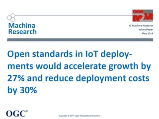
Dynamizers
• Enhance properties of
city objects by
overriding static values
• Time-variant values
from sensors,
simulations, and
external files
Copyright © 2017 Open Geospatial Consortium
Figure 1. Conceptual representation of Dynam izers, allow ing (i) the representation of tim e-variant
values from sensors, sim ulation specific databases, and external files, (ii) enhancing the properties of
city objects by overriding their static values. Im age taken from [3].
OGC
®
Future City Pilot 1 Scenario: Health
• Building Humidity and Heat during weather extremes
– Dynamize: Override static CityGML properties with dynamic
observations from SOS
– Identify residents of senior living facility at risk
Copyright © 2017 Open Geospatial Consortium
Real-time temperature, humidity
accessed from SOS
Visualization of and interaction with 3D
building geometries
OGC
®
Future City Pilot 1 Scenario: Energy
• Provide better services to the citizens and the energy
planners by making sophisticated solar potential analysis.
• Visualization of solar energy
production for roofs and facades
of building
Copyright © 2017 Open Geospatial Consortium
color ram ps. For com paring the solar irradiation values, figure 11 shows the values from the m onth
February and figure 12 shows the values from the m onth August. Figure 13 illustrates all the values
of the solar potential results encoded in a single tim eseries graph. Such tim eseries graphs can be
retrieved and be used for further sim ulations with the help of the dynam izers. Figure 14 shows the
point clou ds in different colors which were generated from the sam pling points for each building
surface for the sim ulation.
Figure 11. Screenshot 1: Solar irradiation values for the m onth February
Figure 13. Screenshot 3: All the values of solar potential results encoded in a single tim eseries graph
OGC
®
Plans for FCP Phase 2
• Call for Sponsors & Requirements 2017
• Also in the Geospatial, Civil Engineering & BIM
• Requirements are coming in
• Worldwide scope
• Include Indoor & Facility Management
– VR, AR?
• Interested to sponsor or participate?
– Let me know!
© 2017 Open Geospatial Consortium
OGC
®
Innovation Program
• Testbed 13 - underway
• Testbed 14 – call for sponsors/requirements out now
– http://www.opengeospatial.org/projects/initiatives/testbed14
• Underground Concept Development Study
– Focus on NYC
– Sponsors – NYC, UK, Singapore
• ArcticSDP
• ESPRESSO
• NextGEOSS (earth observations)
• DHS - IMIS IoT Pilot
Copyright © 2017 Open Geospatial Consortium
OGC
®
DHS - IMIS IoT Pilot
OGC Standards
Used in IMIS IoT Pilot
• Sensor Observation
Service
• Sensor Planning
Service
• SensorThings
• Web Processing
Service
• Catalog
• OWS Context
• Web Feature Service
• Web Map Service
Copyright © 2017 Open Geospatial Consortium
Drone Operator Display
https://www.dhs.gov/publication/incident-management-information-sharing-imis-internet-things-iot-extension-engineering
Live demonstrations in
multiple sites in 2016
Location Powers: Underground
Tuesday 5th September 2017 0900 – 1700
http://www.locationpowers.net/
Geovation Hub, London, UK
OGC
®
OGC Technical Meetings
• June – St John’s, New Foundland, Canada
• September – Ordnance Survey, Southampton, UK
• December – Landcare, Palmerston North, NZ
Copyright © 2017 Open Geospatial Consortium
OGC
®
Domain Working Groups
• 3DIM
• Big Data
• Data Quality
• Earth Systems Science
• Geosemantics
• Health
• Marine
• Mobile Location Services
• Sensor Web Enablement
• Smart Cities
Copyright © 2017 Open Geospatial Consortium
OGC
®
OGC Mobile Location Services Working Group
• Mission of MLS WG: to broaden the use of location-aware
technologies in mainstream consumer and business IT
infrastructures.
– Identify MLS technology requirements and solutions
– Encourage OGC WGs to progress key services and encodings
– Make recommendations for adoption of mass-market, mobile
location services standards.
• Focal point for complementary organizations, such as
– W3C, OSGeo, Web3D Consortium, Eclipse Foundation
– Open Mobile Alliance (OMA), Small Cell Forum, GSMA, CTIA
– Location Based Marketing Association (LBMA)
– In Location Alliance (ILA)
Copyright © 2013 Open Geospatial Consortium
OGC
®
ILA- OGC – i-Locate
global statement
Reminder: Press Announcement Today at 6.15pm
OGC
®
Title
OGC
®
How to get involved?
• Ask for your solutions to be “open” standards compliant
• Become a member
• Join an OGC Forum
• Follow a Domain Working Group
• Visit us at the Technical Meetings in September in
Southampton, UK
• Don’t be passive, be part of standards innovation!
Copyright © 2017 Open Geospatial Consortium
OGC
®
Standards
should be
driven by
innovation
and achieved
through
collaboration
OGC
®
Denise McKenzie
OGC Outreach
+44 7581118189
dmckenzie@opengeospatial.org
@spatialred
@opengeospatial
www.opengeospatial.org

2017 GeoIOTWorld

  • 1.
    ® GeoData Standards PoweringIoT Innovation: Progress and Road Ahead Denise McKenzie Executive Director 7 June 2017Copyright © 2017 Open Geospatial Consortium
  • 2.
  • 3.
    OGC ® Copyright © 2017Open Geospatial Consortium
  • 4.
    OGC ® Copyright © 2017Open Geospatial Consortium
  • 5.
    OGC ® Copyright © 2017Open Geospatial Consortium
  • 6.
    OGC ® Copyright © 2017Open Geospatial Consortium OGC Alliance Partners A Critical Resource for Advancing Standards … and others www.opengeospatial.org/ogc/alliancepartners
  • 7.
  • 8.
    OGC ® SWE today Image courtesyof opensensorhub.org Copyright © 2017 Open Geospatial Consortium
  • 9.
    OGC ® Copyright © 2017Open Geospatial Consortium
  • 10.
    OGC ® An OGC Frameworkfor Smart Cities • “OGC Smart Cities Spatial Information Framework” – https://portal.opengeospatial.org/files/?artifact_id=61 188 • Influenced by: – OGC’s geospatial, sensor, processing, mobile standards work – Survey of Smart City Standards Activities: • JTC 1, ITU, ISO, BSI, DIN, others – Survey of OGC CityGML implementations • Goals: – Pilot Smart Cities Spatial Framework in select cities (http://www.opengeospatial.org/blog/1886) – Advance an OGC Best Practice for Location Enabled Smart Cities OGC Smart Cities Spatial Information Framework
  • 11.
    OGC ® FutureCities Pilot • Coordinatedeffort between OGC and buildingSMART International • Seeking sponsors, most of work is intended to occur in Europe • Pilot will demonstrate and enhance the ability of cities to use diverse, interoperating spatial technologies to deliver improved quality of life, civic initiatives, and resilience Copyright © 2015 Open Geospatial Consortium http://www.opengeospatial.org/pressroom/pressreleases/2290
  • 12.
    OGC ® Copyright © 2017Open Geospatial Consortium
  • 13.
    OGC ® Adding Dynamic Processesto Urban Models Dynamizers • Enhance properties of city objects by overriding static values • Time-variant values from sensors, simulations, and external files Copyright © 2017 Open Geospatial Consortium Figure 1. Conceptual representation of Dynam izers, allow ing (i) the representation of tim e-variant values from sensors, sim ulation specific databases, and external files, (ii) enhancing the properties of city objects by overriding their static values. Im age taken from [3].
  • 14.
    OGC ® Future City Pilot1 Scenario: Health • Building Humidity and Heat during weather extremes – Dynamize: Override static CityGML properties with dynamic observations from SOS – Identify residents of senior living facility at risk Copyright © 2017 Open Geospatial Consortium Real-time temperature, humidity accessed from SOS Visualization of and interaction with 3D building geometries
  • 15.
    OGC ® Future City Pilot1 Scenario: Energy • Provide better services to the citizens and the energy planners by making sophisticated solar potential analysis. • Visualization of solar energy production for roofs and facades of building Copyright © 2017 Open Geospatial Consortium color ram ps. For com paring the solar irradiation values, figure 11 shows the values from the m onth February and figure 12 shows the values from the m onth August. Figure 13 illustrates all the values of the solar potential results encoded in a single tim eseries graph. Such tim eseries graphs can be retrieved and be used for further sim ulations with the help of the dynam izers. Figure 14 shows the point clou ds in different colors which were generated from the sam pling points for each building surface for the sim ulation. Figure 11. Screenshot 1: Solar irradiation values for the m onth February Figure 13. Screenshot 3: All the values of solar potential results encoded in a single tim eseries graph
  • 16.
    OGC ® Plans for FCPPhase 2 • Call for Sponsors & Requirements 2017 • Also in the Geospatial, Civil Engineering & BIM • Requirements are coming in • Worldwide scope • Include Indoor & Facility Management – VR, AR? • Interested to sponsor or participate? – Let me know! © 2017 Open Geospatial Consortium
  • 17.
    OGC ® Innovation Program • Testbed13 - underway • Testbed 14 – call for sponsors/requirements out now – http://www.opengeospatial.org/projects/initiatives/testbed14 • Underground Concept Development Study – Focus on NYC – Sponsors – NYC, UK, Singapore • ArcticSDP • ESPRESSO • NextGEOSS (earth observations) • DHS - IMIS IoT Pilot Copyright © 2017 Open Geospatial Consortium
  • 18.
    OGC ® DHS - IMISIoT Pilot OGC Standards Used in IMIS IoT Pilot • Sensor Observation Service • Sensor Planning Service • SensorThings • Web Processing Service • Catalog • OWS Context • Web Feature Service • Web Map Service Copyright © 2017 Open Geospatial Consortium Drone Operator Display https://www.dhs.gov/publication/incident-management-information-sharing-imis-internet-things-iot-extension-engineering Live demonstrations in multiple sites in 2016
  • 19.
    Location Powers: Underground Tuesday5th September 2017 0900 – 1700 http://www.locationpowers.net/ Geovation Hub, London, UK
  • 20.
    OGC ® OGC Technical Meetings •June – St John’s, New Foundland, Canada • September – Ordnance Survey, Southampton, UK • December – Landcare, Palmerston North, NZ Copyright © 2017 Open Geospatial Consortium
  • 21.
    OGC ® Domain Working Groups •3DIM • Big Data • Data Quality • Earth Systems Science • Geosemantics • Health • Marine • Mobile Location Services • Sensor Web Enablement • Smart Cities Copyright © 2017 Open Geospatial Consortium
  • 22.
    OGC ® OGC Mobile LocationServices Working Group • Mission of MLS WG: to broaden the use of location-aware technologies in mainstream consumer and business IT infrastructures. – Identify MLS technology requirements and solutions – Encourage OGC WGs to progress key services and encodings – Make recommendations for adoption of mass-market, mobile location services standards. • Focal point for complementary organizations, such as – W3C, OSGeo, Web3D Consortium, Eclipse Foundation – Open Mobile Alliance (OMA), Small Cell Forum, GSMA, CTIA – Location Based Marketing Association (LBMA) – In Location Alliance (ILA) Copyright © 2013 Open Geospatial Consortium
  • 23.
    OGC ® ILA- OGC –i-Locate global statement Reminder: Press Announcement Today at 6.15pm
  • 24.
  • 25.
    OGC ® How to getinvolved? • Ask for your solutions to be “open” standards compliant • Become a member • Join an OGC Forum • Follow a Domain Working Group • Visit us at the Technical Meetings in September in Southampton, UK • Don’t be passive, be part of standards innovation! Copyright © 2017 Open Geospatial Consortium
  • 26.
  • 27.
    OGC ® Denise McKenzie OGC Outreach +447581118189 dmckenzie@opengeospatial.org @spatialred @opengeospatial www.opengeospatial.org

Editor's Notes

  • #8 SWE standards are developed and maintained by OGC members who participate the OGC Technical Committee's Sensor Web Enablement Working Group . SWE offers integrators: Open interfaces for sensor web applications "Hooks" for IEEE 1451, TML, CAP, WS-N, ASAP Imaging device interface support Opportunity to participate in an open process to shape standards Sensor location tied to geospatial standards Fusion of sensor data with other spatial data Ties to IEEE and other standards organizations Sensor technology, computer technology and network technology are advancing together while demand grows for ways to connect information systems with the real world. Linking diverse technologies in this fertile market environment, integrators are offering new solutions for plant security, industrial controls, meteorology, geophysical survey, flood monitoring, risk assessment, tracking, environmental monitoring, defense, logistics and many other applications. The SWE effort involves OGC members in developing the global framework of standards and best practices that make linking of diverse sensor related technologies fast and practical. Standards make it possible to put the pieces together in an efficient way that protects earlier investments, prevents lock-in to specific products and approaches, and allows for future expansion. Standards also influence the design of new component products. Business needs drive the process. Technology providers and solutions providers need to stay abreast of these evolving standards if they are to stay competitive. OGC Standards The main adopted or pending OGC Standards in the SWE framework include: Observations & Measurements (O&M) –The general models and XML encodings for observations and measurements. PUCK Protocol Standard – Defines a protocol to retrieve a SensorML description, sensor "driver" code, and other information from the device itself, thus enabling automatic sensor installation, configuration and operation.  Sensor Model Language (SensorML) – Standard models and XML Schema for describing the processes within sensor and observation processing systems. Sensor Observation Service (SOS) – Open interface for a web service to obtain observations and sensor and platform descriptions from one or more sensors. Sensor Planning Service (SPS) – An open interface for a web service by which a client can 1) determine the feasibility of collecting data from one or more sensors or models and 2) submit collection requests. SWE Common Data Model – Defines low-level data models for exchanging sensor related data between nodes of the OGC® Sensor Web Enablement (SWE) framework. SWE Service Model ­– Defines data types for common use across OGC Sensor Web Enablement (SWE) services. Five of these packages define operation request and response types. Other SWE standards are under discussion or in various stages of development. The OGC and Sensors The OGC® is an international industry consortium of more than 330 companies, government agencies, research organizations, and universities participating in a consensus process to develop publicly available interface standards. The OGC has become involved in the sensor web standards effort because this technology domain needs standards that address a broad set of critical real world information interoperability demands, including information about location. OGC members have reached agreement on the most of the issues involving digital communication about location, motion, coordinate systems, spatial operations, raster and vector representations of features and phenomena, etc. Many of the major software vendors, solution providers and government members who want sensor web standards were already involved in the OGC consensus process. And the OGC has demonstrated its ability to facilitate a process in which members can rapidly develop, test and validate standards and harmonize them with standards from other standards organizations. Key components of the OGC standards process are the OGC Innovation Program and the OGC Specification Program The OGC Innovation Program (IP) is a global, hands-on and collaborative prototyping program designed to rapidly develop, test and deliver proven candidate standards into OGC's Specification Program, where they are formalized for public release. OGC Innovation Program Initiatives include test beds, pilot projects, and interoperability experiments The OGC Specification Program provides an effective and well-trusted industry consensus process to plan, review and officially adopt OGC Standards for interfaces, encodings and protocols that enable interoperable services, data, and applications. The Specification Program consists of two primary organizational units, the OGC Technical Committee (TC) and the OGC Planning Committee (PC).
  • #19 Incident Management Information Sharing (IMIS) Internet of Things (IoT) Extension Engineering Report The Incident Management Information Sharing (IMIS) Internet of Things (IoT) Pilot established the following objectives: Apply Open Geospatial Consortium (OGC) principles and practices for collaborative development to existing standards and technology in order to prototype an IoT approach to sensor use for incident management. Employ an agile methodology for collaborative development of system designs, specifications, software and hardware components of an IoT-inspired IMIS sensor capability. Development of profiles and extensions of existing Sensor Web Enablement (SWE) and other distributed computing standards to provide a basis for future IMIS sensor and observation interoperability. Prototype capabilities documented in engineering reports and demonstrated in a realistic incident management scenario. These principles continued through the IoT Pilot Extension, with additional objectives of: Integration into the existing Next Generation First Responder (NGFR) Apex development program process as part of Spiral 1. Steps to begin the integration of existing incident management infrastructure, e.g., pulling in National Institute of Emergency Management (NIEM) message feeds. Demonstration and experimentation in a ‘realistic’ incident environment using two physically separate sites–an incident site within an active first responder training facility (Fairfax County Lorton site), and a command center (DHS S&T Vermont Avenue facility). The initial Pilot activity has been documented in three OGC public engineering reports. This present report describes and documents the additional activities and innovations undertaken in the Extension.
  • #35 The Standards of organisations such as the OGC belong to all