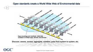
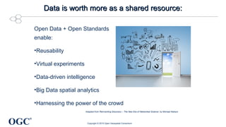
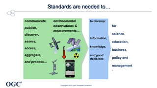
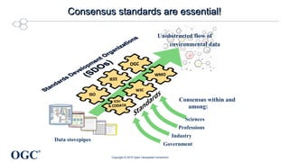
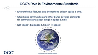
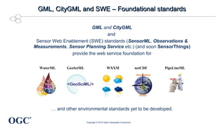
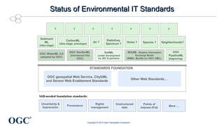
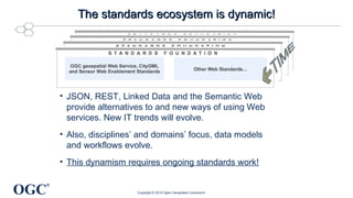
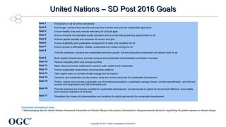
Denise McKenzie gave a presentation on open standards for sustainable development at Locate15 in Brisbane, Australia. She discussed how open standards can help create a "World Wide Web of environmental data" by enabling data discovery, access, and sharing. Key open standards mentioned include OGC standards like GML, CityGML, and Sensor Web Enablement, as well as other emerging standards. Open standards are needed to support environmental monitoring, accounting, and tracking progress on the UN's Sustainable Development Goals.
This is the scrolling slide set used throughout the 4 gala dinners that were held in Crystal City (USA), Geneva (Switzerland), Calgary (Canada) and Tokyo (Japan)
More Creative PowerPoint techniques are shared at :
http://www.facebook.com/pages/Creative-Multimedia/277702235616186
http://kreatifpowerpoint.blogspot.com/
I think this vaccine should be known for the people who are not familier for the health.
What is Vaccine.?
How many type of Influrenza flu.?
I will be happy for the knowledge....Neon Mg Mg
I created this presentation to accompany a lesson plan for my master's thesis: "East and West Coast Ports of Entry to the United States During the New Immigration Era - 1900 to 1925: An South Asian Perspective."
UME Golf is a supercharged social-mobile platform that connects golfers with friends and over 20,000 golf courses in canada and the us using a set of cool tools to find, book, play, rate and connect your game! Look for our iPhone app available for the 2012 season. Play on!
Climate Data Sharing for Urban Resilience - OGC Testbed 11George Percivall
OGC Testbed 11:
Delivering on our commitment to the Climate Data Initiative
In December 2014 the US White House Office of Science and Technology (OSTP) released a Policy Fact Sheet titled "Harnessing Climate Data to Boost Ecosystem & Water Resilience." The Fact Sheet includes OGC’s commitment to increase open access to climate change information using open standards. Testbed 11 results are now available delivering on that commitment.
The results of this major interoperability testbed contribute to development and refinement of international standards that are critical for the communication and integration of geospatial information. http://www.opengeospatial.org/projects/initiatives/testbed11
• Nine sponsors provided requirements and funding for Testbed 11.
• Thirty organizations participated in Testbed 11 by contributing prototypes, engineering
reports and participating in a scenario driven demonstration of the technical advances Technical results of Testbed 11 relevant to the Climate Data Initiative include:
• Analysis and prediction based on open climate data accessed using open standards
• Making predictive models more accessible with OGC Web Processing Service (WPS)
• Verifying model predictions using mobile operations, in-situ gauges and social media.
Climate adaptation, resilience and security planning based on technology from OGC Testbed 11:
• Estimating geographic extend of coastal inundation in dynamic weather conditions
• Assessing social unrest with displaced population due to climate change
• Integrating spatial and non-spatial models of human geography and resilience
• Predictive models and verifications to support planning and response phases
Presentation to for the ISPRS Congress 2012, Melbourne
Over the last decade, standards have played a key role in the expansion of the market for Earth Observation (EO) products and services. Standards become increasingly important as geospatial technologies and markets continue to evolve in an increasingly complex technology ecosystem. OGC and ISPRS work jointly to further the development of this vital information industry.
We continue to see global growth in the supply of geometrically controlled image-based geodata. On the data supplier side, most end-use EO information products use data from multiple EO sources (aerial and satellite) as well as from ground-based sources. On the customer side, customers’ business models involving EO data require easy connections between multiple data suppliers and multiple technology platforms. Typically, new markets create stovepiped, proprietary solutions that persist until market forces create demand for standards that in turn enhance market opportunity. The OGC’s standards meet this demand in the geospatial markets.
OGC leads worldwide in the creation and establishment of standards that allow geospatial content and services to be seamlessly integrated into business and civic processes, the spatial web and enterprise computing. OGC accelerates market assimilation of interoperability research through collaborative consortium processes.
OGC has both domain focused and technology focused activities. For example, the Meteorology & Oceanography Domain Working Group ensures that OGC standards and profiles allow the meteorological community to develop effective interoperability for web services and content across the wider geospatial domain. These needs are met for example by the technology of standards such as netCDF which was brought into the OGC to encourage broader international use and greater interoperability among clients and servers interchanging data in binary form.
Most OGC standards specify open interfaces or encodings that apply to imagery. Some of these are:
o Web Coverage Service (WCS)
o Web Coverage Processing Service (WCPS)
o Web Map Service (WMS)
o Geography Markup Language (GML)
o GML in JPEG 2000 Encoding
o OGC Network Common Data Form (NetCDF)
o Sensor Observation Service (SOS)
o Sensor Planning Service (SPS)
o Sensor Model Language Encoding Standard (SensorML).
o Catalogue Service for the WEB (CSW)
Open standards: A success factor for smart citiesIngo Simonis
Smart Cities and the role of geospatial standards to optimize data exchange and service interoperability across data and service providers. Keynote given at AGIT 2015
A short introduction to GEO governance, the GEO Work Programme and the GEO community for the FOSS4G audience. Contributions on GEOGLOWS, eShape and GEOHack19 from Julia Wagemann, Valentina Balcan and Diana Mastracci.
Progress towards Open Standards-Based Agro-GeoinformaticsGeorge Percivall
Keynote presentation to Agro-Geoinformatics Conference
20 July 2015, Istanbul, Turkey
http://agro-geoinformatics.org/
** What is agro-geoinformatics and why need for exchange of Agriculture Geo-Information?
Efficient exchange of data on utilization of farmland, soil and crop characteristics, water availability, environmental impacts, …
Many user roles: growers, advisors, landowners, foodstuff processors, regulators and all levels of government
Major challenges to agricultural: climate change, increasing population, shortage of water and arable land
Increasing need for information standards to support transparency in agricultural goods and services markets
** Projects showing the progress of standards-based agro-geoinformatics technology
SoilML for information exchange
Soil information platforms
Precision Agriculture and In-situ networks
Remote sensing from satellites and drones
Big Data processing for decision support
Climate - Food - Water nexus
** OGC support of Agro-Geoinformatics
- Agriculture Domain Working Group
Identify geospatial interoperability challenges in agriculture domain
Forum to identify standards-based solutions, new standards
- Discrete Global Grid Systems standards development
Geometric partitioning of Earth surface into cells with identifiers
Enable fusion of disparate data for spatial analysis and modeling
- Soil Data Interoperability Experiment (SoilIE)
Testing standards for exchange of soils data
Results to converge and mature soil information standards.
Get involved as participant or an observer, contact:
David Medyckyj-Scott Medyckyj-Scottd@landcareresearch.co.nz
…and others
Solving sustainability challenges with geospatial informationEsri UK
An understanding of location is vital for helping both organisations and governments to reach their sustainability goals. Indeed, geospatial data plays a pivotal role in everything from planning renewable energy policies and rolling out infrastructure for electric cars nationwide, to enhancing the natural capital around an office building or improving waste collection at a business park. This presentation will reveal how Ordnance Survey uses innovation to help its customers see a sustainable place. Learn about a series of ground-breaking propositions that blend geospatial and earth observation technologies to solve some of the world’s most complex sustainability challenges.
Keynote, Oman Geospatial Expo, Dec 2013Steven Ramage
Invited by Geospatial Media and Oman National Survey Authority (NSA) to deliver overview of current activities relating to international geospatial standards, including ongoing work through United Nations initiative on Global Geospatial Information Management (UN-GGIM).
2012 Emerging Tech, OGC Standards, Mobile Platforms, and the Internet of Thin...GIS in the Rockies
Mobile devices are rapidly becoming the preferred platform for geospatial technology access and use. Mobile technology and market forces are shaping the mobile internet, of which mobile GIS is a component. A convergence of mobile technology, bandwidth, sensors, real time data access, standards, and user demand is creating a rich environment for forward thinking in geospatial standards development. In response, the Open Geospatial Consortium (OGC) has a number of standards activities focused on the requirements of the mobile geospatial/GIS community. This presentation will provide an overview of the most recent standards work in the OGC related to the mobile internet. This work includes development of ARML (Augmented Reality Markup Language), InDoorGML (model and encoding for semantically rich indoor/building content), Open GeoSMS (location enabled SMS), and the Sensor Web for the Internet of Things (IoT).
The aim of this primer is to putforth a perspective on - how does sustainability matters in real estate sector and why it should be a prime agenda of firms in making environmental friendly decision making and operations. Real estate sector can showcase their stewardship towards environment via efficient environmental friendly policies. There are varied environmental standards which are applied at the builings or infrastructure level in real estate sector, however what it lacks is uniformity in sustainability applicability to the sector. The type of material used, the design per se, installations and retrofits all matter in real esate sustainability mission and vision. Understanding environmental and climate risks and its real implications is a intricate challenge for property investors.
Transformative evaluation:State of the Environment Reporting framed by the U...GillianSparkesPhDMBA
Victorian Commissioner for Environmental Sustainability Dr Gillian Sparkes' keynote address on October 30, 2019 at the 2019 Energy Evaluation Asia Pacific Conference in Bangkok, Thailand
Characterization and the Kinetics of drying at the drying oven and with micro...Open Access Research Paper
The objective of this work is to contribute to valorization de Nephelium lappaceum by the characterization of kinetics of drying of seeds of Nephelium lappaceum. The seeds were dehydrated until a constant mass respectively in a drying oven and a microwawe oven. The temperatures and the powers of drying are respectively: 50, 60 and 70°C and 140, 280 and 420 W. The results show that the curves of drying of seeds of Nephelium lappaceum do not present a phase of constant kinetics. The coefficients of diffusion vary between 2.09.10-8 to 2.98. 10-8m-2/s in the interval of 50°C at 70°C and between 4.83×10-07 at 9.04×10-07 m-8/s for the powers going of 140 W with 420 W the relation between Arrhenius and a value of energy of activation of 16.49 kJ. mol-1 expressed the effect of the temperature on effective diffusivity.
Presented by The Global Peatlands Assessment: Mapping, Policy, and Action at GLF Peatlands 2024 - The Global Peatlands Assessment: Mapping, Policy, and Action
Improving the viability of probiotics by encapsulation methods for developmen...Open Access Research Paper
The popularity of functional foods among scientists and common people has been increasing day by day. Awareness and modernization make the consumer think better regarding food and nutrition. Now a day’s individual knows very well about the relation between food consumption and disease prevalence. Humans have a diversity of microbes in the gut that together form the gut microflora. Probiotics are the health-promoting live microbial cells improve host health through gut and brain connection and fighting against harmful bacteria. Bifidobacterium and Lactobacillus are the two bacterial genera which are considered to be probiotic. These good bacteria are facing challenges of viability. There are so many factors such as sensitivity to heat, pH, acidity, osmotic effect, mechanical shear, chemical components, freezing and storage time as well which affects the viability of probiotics in the dairy food matrix as well as in the gut. Multiple efforts have been done in the past and ongoing in present for these beneficial microbial population stability until their destination in the gut. One of a useful technique known as microencapsulation makes the probiotic effective in the diversified conditions and maintain these microbe’s community to the optimum level for achieving targeted benefits. Dairy products are found to be an ideal vehicle for probiotic incorporation. It has been seen that the encapsulated microbial cells show higher viability than the free cells in different processing and storage conditions as well as against bile salts in the gut. They make the food functional when incorporated, without affecting the product sensory characteristics.
ENVIRONMENT~ Renewable Energy Sources and their future prospects.tiwarimanvi3129
This presentation is for us to know that how our Environment need Attention for protection of our natural resources which are depleted day by day that's why we need to take time and shift our attention to renewable energy sources instead of non-renewable sources which are better and Eco-friendly for our environment. these renewable energy sources are so helpful for our planet and for every living organism which depends on environment.
"Understanding the Carbon Cycle: Processes, Human Impacts, and Strategies for...MMariSelvam4
The carbon cycle is a critical component of Earth's environmental system, governing the movement and transformation of carbon through various reservoirs, including the atmosphere, oceans, soil, and living organisms. This complex cycle involves several key processes such as photosynthesis, respiration, decomposition, and carbon sequestration, each contributing to the regulation of carbon levels on the planet.
Human activities, particularly fossil fuel combustion and deforestation, have significantly altered the natural carbon cycle, leading to increased atmospheric carbon dioxide concentrations and driving climate change. Understanding the intricacies of the carbon cycle is essential for assessing the impacts of these changes and developing effective mitigation strategies.
By studying the carbon cycle, scientists can identify carbon sources and sinks, measure carbon fluxes, and predict future trends. This knowledge is crucial for crafting policies aimed at reducing carbon emissions, enhancing carbon storage, and promoting sustainable practices. The carbon cycle's interplay with climate systems, ecosystems, and human activities underscores its importance in maintaining a stable and healthy planet.
In-depth exploration of the carbon cycle reveals the delicate balance required to sustain life and the urgent need to address anthropogenic influences. Through research, education, and policy, we can work towards restoring equilibrium in the carbon cycle and ensuring a sustainable future for generations to come.
different Modes of Insect Plant InteractionArchita Das
different modes of interaction between insects and plants including mutualism, commensalism, antagonism, Pairwise and diffuse coevolution, Plant defenses, how coevolution started
UNDERSTANDING WHAT GREEN WASHING IS!.pdfJulietMogola
Many companies today use green washing to lure the public into thinking they are conserving the environment but in real sense they are doing more harm. There have been such several cases from very big companies here in Kenya and also globally. This ranges from various sectors from manufacturing and goes to consumer products. Educating people on greenwashing will enable people to make better choices based on their analysis and not on what they see on marketing sites.
Top 8 Strategies for Effective Sustainable Waste Management.pdfJhon Wick
Discover top strategies for effective sustainable waste management, including product removal and product destruction. Learn how to reduce, reuse, recycle, compost, implement waste segregation, and explore innovative technologies for a greener future.
WRI’s brand new “Food Service Playbook for Promoting Sustainable Food Choices” gives food service operators the very latest strategies for creating dining environments that empower consumers to choose sustainable, plant-rich dishes. This research builds off our first guide for food service, now with industry experience and insights from nearly 350 academic trials.
2. OGC
®
Who am I?Who am I?
Executive Director
Communications & Outreach
Open Geospatial Consortium
Australian Citizen
UK Resident
Global traveler
@spatialred
Sustainabile Development – UN focus on how the world will continue to develop
Urban Resilience
UN SD goals later this year.
COBWEB at GGIM and VGI and citizen science
Epoch or Era of the world – in the same way that we classify the Jurassic period.
Commissioned in 2012 by the Planet Under Pressure for a conference in London.
https://www.youtube.com/watch?v=fvgG-pxlobk
Data from OGC members such as NASA, NOAA, NGA
There’s solid scientific consensus on global warming.
I (we) thought the 1972 Limits to Growth findings had been discredited, but this Australian Research shows that we still face serious challenges from population and resource depletion.
Change behavior BASEDO ON FACTS!
So we can discover, assess, verify, access, aggregate, combine, reuse, and pass data from model to model…
When apps implement standards, “citizen science” creates better data and better metadata. Enhancing citizen scientists’ real value enhances their love of science.
Deveolop a model in IT space of the environment
Spatial awareness at all levels, esp IOT hyperlocal geography and spatial awareness
All depend on environmental evidence:
National income accounting, financial accounting, & internal business managerial accounting:
B corporations
Cap and trade schemes
City rating systems (STAR, C40, ISO 37120, etc.)
Environmental impact statements
Environmental regulation
Environmental taxes
Human Development Index
Human Security Index
Triple bottom line accounting
Trustable measurements & trustable, transparent,
and digitally useful communication of measurements of
Greenhouse gases
Hazards & risk
Health
Physical Infrastructure
Pollution
Resources
Wastes
etc.
A domain that develops a domain-specific data encoding standard based on OGC standards and on the domain's semantic standards gives domain participants much fuller access to developments in the mainstream digital technology world: Web searches, chained computer models, full use of cloud infrastructures, Big Data, data analytics, data fusion, management tools for open data, heterogeneous sensor webs and much more .
Need some discussion of the modeling and “management” of uncertainty and inherent inprecission at some point.
Dotted border indicates standard is not adopted yet. (Not sure about JRC’s SoilML.)
Technology does not stay still – advancements and developments will always mean that we need to continue working together to define our.
Whereas sustainable development depends on the communication of environmental data, and
Whereas such communication depends on open standards,
We call upon funding agencies to support research in
Developing information requirements for environmental value chains and workflows, addressing users’ needs to publish, discover, assess, access, aggregate, analyze and display environmental data and information.
Analyzing the open data encodings and interfaces necessary for accomplishing these use cases in open distributed computing environments.
Providing estimates of the societal and industry stakeholder value that would be realized through development of such encodings and interfaces.
Also, implementing and testing candidate standards.
The OGC calls upon academic, industry, foundation and government leaders to
Appeal to funding agencies to support standards work that supports sustainable development.
Consider the value that would accrue to their stakeholders if they were to help develop one or more of the standards and best practices suggested by the studies proposed here.
Work with the appropriate standards development organizations to begin developing those standards.