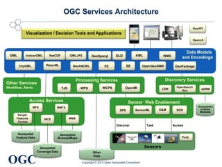
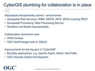
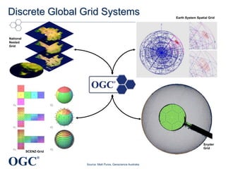
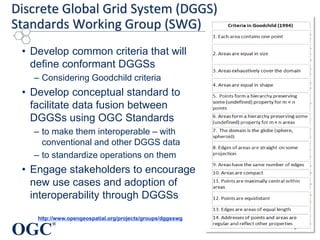
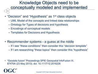
The document discusses CyberGIS architectures for collaborative problem solving. It states that the geospatial interoperability plumbing is in place through standards like OGC web services. However, improvements are still needed for big data applications and discrete global grid systems. It also notes that conceptual models and implementations are needed for knowledge objects like decisions and hypotheses to fully enable collaborative knowledge environments.
Evolution of System Architectures: Where Do We Need to Fail Next?Luis Bermudez
Innovation requires testing and failing. Thomas Edison was right when he said "I have not failed. I've just found 10,000 ways that won't work". For innovation and improvement of standards to happen, service Architectures have to be tested and tested. Within the Open Geospatial Consortium (OGC), testing of service architectures has occurred for the last 15 years. This talk will present an evolution of these service architectures and a possible future path.
This talk opened the geospatial track of the Apache Big Data conference. The geospatial track aimed to increase the benefits of implementing open source consistent with open geospatial standards.
After an introduction of the geospatial track this talk focused on these topics:
- Applications of Big Geo Data
- Geospatial Open Standards
- Big Geo Use Cases
- Open Source and Open Standards.
Analysis Ready Data workshop - OGC presentation George Percivall
The Open Geospatial Consortium (OGC) has activities relevant to the workshop scope of "the current state-of-the-art in satellite data interoperability”. This presentation will focus on two main topics with the option to discuss other relevant topics that the participants may wish to discuss, e.g., WFS3. The two focus areas of development: 1) Geospatial Datacubes and 2) Earth Observation Exploitation Platforms. 1) A Geospatial Datacube provides access to and analytics on analysis ready data (ARD) organized with coordinate axes of space and time with cells in the cube containing data of geospatial features, e.g., imagery. OGC members implementing geospatial datacubes are documenting common practices to spur development and leading to the possibility to federated geospatial datacubes. 2) OGC is forming a Earth Observation Exploitation Platform Domain Working Group with the goal of defining a standards-based framework for cloud-based access to and analysis of EO data. An ad-hoc meeting was held in March 2018 to scope the working group with the results issued in a request for comment: http://www.opengeospatial.org/pressroom/pressreleases/2792
OGC Update for State of Geospatial Tech at T-RexGeorge Percivall
An update on OGC activities in three time horizons: Now, Next and After Next. Finishing with how to keep updated on OGC activities.
Now
Recently approved OGC standards
Implementation of approved standards
Next
Standards Program
Innovation Program
After Next
Tech Forecast
How to keep in touch
Geospatial Temporal Open Standards for Big Data from Space (BiDS2014)George Percivall
Presentation to ESA Big Data From Space (BiDS2014), November 2014.
Big data from space requires processing large amounts of data in a distributed environment. For efficient, quality and cost-effective deployment, these environments must be based on open standards. The Open Geospatial Consortium (OGC) open standards for geospatial-temporal information have been tuned through implementations to meet the needs of big data.
"The Golden Age of Geospatial Data Science and Engineering" presented as the inital lecture in the Geospatial Data Science Distinguished Speaker Series at the University of Illinois, Urbana-Champaign. Series organized and presented by Professor Shaowen Wang, Head of the Geography and Geographic Information Science Department.
"Data Science is in a golden age. The mathematical foundations of Data Science, known for many years, are now seeing broad applicability due to engineering advances in cloud and big data computing and due to the explosive availability of data about nearly every aspect of human activity coming from mobile devices, remote sensing and the Internet of Things. Nearly all of this data has components of location and time leading to stunning advances in geospatial data science. Development of intelligent systems using knowledge models leading to insights and understanding have the potential to significantly transform geospatial data sciences. To achieve the fullest extent of their potential, these innovations require establishment of open consensus standards. This talk will review recent developments in innovations, standards, and applications of geospatial data science and engineering."
Presentation Location and Context World, 2015. Palo Alto, CA November 3-4, 2015.
Abstract: Creating useful local context requires big data platforms and marketplaces. Contextual awareness is relevant to location based marketing, first responders, urban planners and many others. Location-aware mobile devices are revolutionizing how consumers and brands interact in the physical world. Situational awareness is a key element to efficiently handling any emergency response. In all cases, big data processing and high velocity streaming of location based data creates the richest contextual awareness. Data from many sources including IoT devices, sensor webs, surveillance and crowdsourcing are combined with semantically-rich urban and indoor data models. The resulting context information is delivered to and shared by mobile devices in connected and disconnected operations. Standards play a key role in establishing context platforms and marketplaces. Successful approaches will consolidate data from ubiquitous sensing technologies on a common space-time basis to enabled context-aware analysis of environmental and social dynamics.
TITLE: Open Standards Role in EarthCube (Invited)
AUTHORS (FIRST NAME, LAST NAME): Luis E Bermudez1, David K Arctur2, 1, George Percivall1
INSTITUTIONS (ALL): 1. Open Geospatial Consortium, Gaithersburg, MD, United States.
2. University of Texas at Austin, Austin, TX, United States.
ABSTRACT BODY: EarthCube is an NSF initiative that will enable sharing of data in an open and transparent manner, improving access and use of data, allowing scientists to better understand the Earth. EarthCube is based on a network of enthusiasts willing to make the sharing of data a reality. But is just having open data enough? Open data will not accelerate the process a scientist team needs to go through to understand, reformat and use the data. However, agreements among colleagues or adoption of agreements can make a big difference. These agreements also need to be published, freely available, and unpolluted from intellectual property rights issues. The system design requirements to develop cyberinfrastructure for Geosciences need to take into account these open agreements, including open interfaces and open encodings. Once open agreements are in place, it is essential to have in place policy and procedures, and a governance body for maintaining those agreements. This presentation will explore these issues and suggest ways the standard development organizations, like the Open Geospatial Consortium (OGC), and other coordinating organizations, such as the Earth Science Information Partners (ESIP) and the Research Data Alliance (RDA), could be involved in this process.
http://www.opengeospatial.org
In AGU 2013 Session: IN43B. Emerging Concepts for Cyberinfrastructure in the Geosciences
Scientific Knowledge from Geospatial ObservationsGeorge Percivall
Presentation to IGARSS 2015 Conference, July 205, Milan Italy.
Part of invited session: Why Data Matters: Value of Stewardship and Knowledge Augmentation Services
UAVs are a disruptive technology bringing new geographic data and information to many application domains. UASs are similar to other geographic imagery systems so existing frameworks are applicable. But the diversity of UAVs as platforms along with the diversity of available sensors are presenting challenges in the processing and creation of geospatial products. Efficient processing and dissemination of the data is achieved using software and systems that implement open standards. The challenges identified point to the need for use of existing standards and extending standards. Results from the use of the OGC Sensor Web Enablement set of standards are presented. Next steps in the progress of UAVs and UASs may follow the path of open data, open source and open standards.
Time, Change and Habits in Geospatial-Temporal Information StandardsGeorge Percivall
Keynote for HIC 2014 – 11th International Conference on Hydroinformatics, New York, USA August 17 – 21, 2014
Time, Change and Habits in Geospatial-Temporal Information Standards
Time and change are fundamental to our scientific understanding of the world. Standards for geospatial-temporal information exist but new needs outstrip current standards. Geospatial-temporal information includes capturing change in features and coverages and modeling the processes that inform change. Key standards for time, calendars, and temporal reference systems are in place. Time series modeling from the WaterML standard is a recent advance of high value to hydrology. The OGC Moving Features standard will establish an encoding format for changes in “rigid” features. Interoperability standards are needed for Coverages with values that change based on observations, analytical expressions, or simulations. Applying a coverage model to time-varying, fluid Earth systems was the topic of the ground breaking GALEON Interoperability Experiment. Standards developments for spatial-temporal process models is progressing with WPS, OpenMI and ESMF - supporting a Model Web concept. A robust framework for sharing geospatial-temporal information is now coming into place based on developments captured in standards by ISO, WMO, ITU, ICSU and OGC - including the newly established OGC Temporal domain working group. The new framework will enable capabilities in expressing and sharing scientific investigations including research on the emergence of forms over time. With these new capabilities we may come to understand Peirce’s observation that over time “all things have a tendency to take habits.”
Keynote presentation to New Zealand Geospatial Research Conference 2015. This presentation covered emerging topics for geospatial research in four areas:
- Spatial Representation: urban models, CityGML, indoor and DGGS
- New Data Sources: sensors everywhere, IoT, UAVs citizen observations, social media
- Computer Engineering: Big data, moving features, spatial analytics, mobile, 3D portrayal, augmented reality
- Application Areas: Soils Interoperability Experiment, Urban Climate Resilience in OGC Testbed 11.
Innovation in Geospatial Technology and StandardsGeorge Percivall
All predictions are wrong; some are useful. This presentation offers a slate of geospatial trends developed in discussion with the OGC Board of Directors and expanded in an OGC blog series. These geospatial technology issues were developed by reviewing over 200 articles from geospatial publications as well as from information technology journals (IEEE, ACM, etc.).
These "Ripe Issues" of geospatial technology identify areas where further development of open standards can lead to great benefit:
* The Power of Location
* Internet of Things
* Mobile Development
* Indoor Frontier
* Cartographers of the future
* Big Processing of GeoData
* Smart Cities
The OGC is an international consortium where members participate in a consensus process to develop publicly available geospatial standards. OGC has a history of developing anticipatory standards. OGC is a leader in achieving a consensus balanced with innovation where OGC members actively designing the standard while implementing running software. In the role of OGC Chief Engineer, George Percivall identifies technology and market trends relevant to open standards development.
Climate Data Sharing for Urban Resilience - OGC Testbed 11George Percivall
OGC Testbed 11:
Delivering on our commitment to the Climate Data Initiative
In December 2014 the US White House Office of Science and Technology (OSTP) released a Policy Fact Sheet titled "Harnessing Climate Data to Boost Ecosystem & Water Resilience." The Fact Sheet includes OGC’s commitment to increase open access to climate change information using open standards. Testbed 11 results are now available delivering on that commitment.
The results of this major interoperability testbed contribute to development and refinement of international standards that are critical for the communication and integration of geospatial information. http://www.opengeospatial.org/projects/initiatives/testbed11
• Nine sponsors provided requirements and funding for Testbed 11.
• Thirty organizations participated in Testbed 11 by contributing prototypes, engineering
reports and participating in a scenario driven demonstration of the technical advances Technical results of Testbed 11 relevant to the Climate Data Initiative include:
• Analysis and prediction based on open climate data accessed using open standards
• Making predictive models more accessible with OGC Web Processing Service (WPS)
• Verifying model predictions using mobile operations, in-situ gauges and social media.
Climate adaptation, resilience and security planning based on technology from OGC Testbed 11:
• Estimating geographic extend of coastal inundation in dynamic weather conditions
• Assessing social unrest with displaced population due to climate change
• Integrating spatial and non-spatial models of human geography and resilience
• Predictive models and verifications to support planning and response phases
Progress towards Open Standards-Based Agro-GeoinformaticsGeorge Percivall
Keynote presentation to Agro-Geoinformatics Conference
20 July 2015, Istanbul, Turkey
http://agro-geoinformatics.org/
** What is agro-geoinformatics and why need for exchange of Agriculture Geo-Information?
Efficient exchange of data on utilization of farmland, soil and crop characteristics, water availability, environmental impacts, …
Many user roles: growers, advisors, landowners, foodstuff processors, regulators and all levels of government
Major challenges to agricultural: climate change, increasing population, shortage of water and arable land
Increasing need for information standards to support transparency in agricultural goods and services markets
** Projects showing the progress of standards-based agro-geoinformatics technology
SoilML for information exchange
Soil information platforms
Precision Agriculture and In-situ networks
Remote sensing from satellites and drones
Big Data processing for decision support
Climate - Food - Water nexus
** OGC support of Agro-Geoinformatics
- Agriculture Domain Working Group
Identify geospatial interoperability challenges in agriculture domain
Forum to identify standards-based solutions, new standards
- Discrete Global Grid Systems standards development
Geometric partitioning of Earth surface into cells with identifiers
Enable fusion of disparate data for spatial analysis and modeling
- Soil Data Interoperability Experiment (SoilIE)
Testing standards for exchange of soils data
Results to converge and mature soil information standards.
Get involved as participant or an observer, contact:
David Medyckyj-Scott Medyckyj-Scottd@landcareresearch.co.nz
…and others
Raj Singh talks about the history of OGC standards such as Sensor Web Enablement Suite -- Sensor Planning Service, Sensor Observation Service, SensorML, Observation & Measurements -- and its IoT companion -- SWEforIoT, and how the geospatial industry is uniquely positioned to take leadership in the emerging Internet of Things space.
GeoSolutions has been involved into a number of projects, ranging from local administrations to global institutions, involving GeoNode deployments, customizations and enhancements. A gallery of projects and use cases will showcase the versatility and effectiveness of GeoNode, both as a standalone application and as a service component, for building secured geodata catalogs and web mapping services. Lastly, ongoing and future developments will be presented ranging from the upcoming integration with MapStore to the monitoring and analytics dashboard or the support for time series data.
SDSC Technology Forum: Increasing the Impact of High Resolution Topography Da...OpenTopography Facility
High-resolution topography is a powerful tool for studying the Earth's surface, vegetation, and urban landscapes, with broad scientific, engineering, and educational-based applications. Over the past decade, there has been dramatic growth in the acquisition of these data for scientific, environmental, engineering and planning purposes. In the US, the U.S. Geological Society is undertaking the 3D Elevation Program (3DEP) to map the entire lower 48 with lidar by 2023.
The richness of these topography datasets make them extremely valuable beyond the application that drove their acquisition and thus are of interest to a large and varied user community. A cyberinfrastructure platform that enables users to efficiently discover, access and process these massive volumes of data increases the impact of investments in collection of the data and catalyzes scientific discovery as well as informs critical decisions that are made across our Nation every day that depend on elevation data, ranging from immediate safety of life, property, and environment to long term planning for infrastructure projects.
Join us to hear about the motivations, technology, and data assets behind the National Science Foundation funded OpenTopography platform, which aims to democratize access to high resolution topographic data. OpenTopography’s innovation is in co-locating massive volumes of topographic data with processing tools that enable users with varied expertise and application domains to quickly and easily access and process data, to enable innovation and decision making.
Open Science and GEOSS: the Cloud Sandbox enablersterradue
As part of the European project GEOWOW, Terradue was invited to present views at the GEO-X event on future endeavors to serve data democracy & science literacy in GEOSS (http://www.earthobservations.org/geoss.shtml)
Application packaging and systematic processing in earth observation exploita...terradue
An overview of Terradue's solutions supporting Earth Observations (EO) Exploitation Platforms across multiple domains.
Presentation done as part of the Open Geospatial Consortium (OGC) Technical Committee ad-hoc meeting for the setup of a new domain working group on EO Exploitation Platforms.
At the core of the Service-Oriented Architecture (SOA) vision is the concept of a ‘service bus’
that can route messages and notifications between any services, whether developed in-house,
purchased from a third-party, or hosted over the Internet. A similar opportunity exists for inte-
grating the complete workflow between people and applications. Routing messages and noti-
fications between applications and their users (and all of those users’ myriad new mobile and
multimedia devices) calls for a Syndication-Oriented Architecture that can unlock a new level of
business intelligence.
Corporate Social Media by Burson-MarstellerDavid H. Rosen
Social media represents the latest evolutionary step in communications technology. Its arrival presents eight challenges to corporate communications leaders. Burson-Marsteller's charge is to help you meet these challenges with measurable success.
The purpose of this two-day workshop was to help marketers build successful multichannel strategies that connect with customers in increasingly meaningful ways across discreet yet interconnected channels. Specifically it focuses on how to: 1) develop a 360 view of customers to inform a channel architecture strategy, 2) deliver personally relevant information through a compelling content and contact strategy, 3) align channels through brand strategy to create a cohesive user experience, 4) integrate measurement across channels for business performance enhancement, and 5) create internal infrastructure and readiness systems that equip organizations to coordinate effective responses to customer needs.
Presentation to for the ISPRS Congress 2012, Melbourne
Over the last decade, standards have played a key role in the expansion of the market for Earth Observation (EO) products and services. Standards become increasingly important as geospatial technologies and markets continue to evolve in an increasingly complex technology ecosystem. OGC and ISPRS work jointly to further the development of this vital information industry.
We continue to see global growth in the supply of geometrically controlled image-based geodata. On the data supplier side, most end-use EO information products use data from multiple EO sources (aerial and satellite) as well as from ground-based sources. On the customer side, customers’ business models involving EO data require easy connections between multiple data suppliers and multiple technology platforms. Typically, new markets create stovepiped, proprietary solutions that persist until market forces create demand for standards that in turn enhance market opportunity. The OGC’s standards meet this demand in the geospatial markets.
OGC leads worldwide in the creation and establishment of standards that allow geospatial content and services to be seamlessly integrated into business and civic processes, the spatial web and enterprise computing. OGC accelerates market assimilation of interoperability research through collaborative consortium processes.
OGC has both domain focused and technology focused activities. For example, the Meteorology & Oceanography Domain Working Group ensures that OGC standards and profiles allow the meteorological community to develop effective interoperability for web services and content across the wider geospatial domain. These needs are met for example by the technology of standards such as netCDF which was brought into the OGC to encourage broader international use and greater interoperability among clients and servers interchanging data in binary form.
Most OGC standards specify open interfaces or encodings that apply to imagery. Some of these are:
o Web Coverage Service (WCS)
o Web Coverage Processing Service (WCPS)
o Web Map Service (WMS)
o Geography Markup Language (GML)
o GML in JPEG 2000 Encoding
o OGC Network Common Data Form (NetCDF)
o Sensor Observation Service (SOS)
o Sensor Planning Service (SPS)
o Sensor Model Language Encoding Standard (SensorML).
o Catalogue Service for the WEB (CSW)
Location Based Services update for Small Cell ForumGeorge Percivall
Presentation about OGC activities on location based services with an emphasis on indoor location and IndoorGML.
Agenda of talk:
- The power of location
- Mission of OGC
- OGC standards
- OpenLS - OGC Open Location Services
- New developments: IndoorGML and others
2015 FOSS4G Track: Open Specifications for the Storage, Transport and Process...GIS in the Rockies
This talk presents an overview of some of the most important Open Specifications (OS) for the storage, transport and processing of geospatial data and why they matter for the development of the next generation of geospatial systems and data infrastructures. What is the importance of being Open? What is the relationship of OS and geospatial software (both FOSS4G and private/proprietary software)? A Web-based system architecture based on OS and FOSS4G will be presented.
The Open Landscape of Geospatial Information: Open data, open source, open standards
Presented at ASPRS GeoTech 2013 conference: http://www.asprspotomac.org/geotech2013/
Abstract:
The many dimensions of "open" provides users with higher quality geospatial information. Open Standards ensures interoperability to information whether its served by proprietary or open source software. Open Source software benefits the development of open standards and leads to a business ecosystem that includes more providers, more partnerships and more customers.[1] In the end the user does not care if the code is open or proprietary. Users care about access to data and the quality of the data. Open Data has advanced with the recent policies from GEOSS Data-CORE [2] and the US Open Government Initiative [3]. Open Earth Observation data from government sources benefits industry and users. Open standards, Open source and Open data can result in higher quality information. The fusion of data from multiple sources results in higher quality. Fusion is possible based on multiple data sources that can be interrelated [4]. Improving Data Quality through knowing the uncertainty and the provenance of derived information is dependent upon an open landscape of geospatial information.
[1] http://wiki.osgeo.org/wiki/Open_Source_and_Open_Standards
[2] http://www.earthobservations.org/geoss_dsp.shtml
[3] http://www.whitehouse.gov/open
[4] http://www.opengeospatial.org/projects/initiatives/fusion2
Ontologies for Emergency & Disaster Management Stephane Fellah
Ogc meeting march 2014
OGC OWS-10 Cross-Community Interoperability
Ontologies for Emergency & Disaster Management
(The application of geospatial linked data)
GeoPackage, OWS Context and the OGC Interoperability ProgramRaj Singh
Overview of GeoPackage, OWS Context and the OGC Interoperability Program Testbed process with details on how OGC testbeds work and the time commitment.
Defining Digital Earth as a virtual representation of all digital information with a geospatial component, this geography attempts to delineate the scope and elements of Digital Earth. The framework for this geography is a set of layers applicable to describing an information system. From bottom to top the layers are physical, data, information, knowledge, decisions and actions. Conclusions of this geography are that some technologies are sufficient for a Digital Earth to come into existence, but some technologies, in particular in the upper layers, need to be developed. Three conclusions are listed in this abstract.
In the physical and data layers, the explosive growth of Internet provides access to much Digital Earth data. However, the bandwidth necessary for high-end Digital Earth clients will not be widely deployed for some time. In the near term it will be necessary to have Digital Earth access points in public places like museums where high bandwidth is available.
Digital Earth information volume is estimated by assuming a fraction of all digital information that has a geospatial component. Estimates place the total volume of recorded information at several thousand petabytes, i.e., several exabytes. It has been regularly postulated in the geographic community that half or more of all information has a geospatial component. Even though we will soon have the capacity to digitally record this volume of information, most of of it will never be looked at by a human. Tools are needed for auto-summarization, distilling the information into knowledge with lower volume and higher semantic content.
To allow decisions and actions based on the knowledge of Digital Earth requires analysis of the knowledge using tools particular to the geospatial domain. As Digital Earth will exist in a distributed service environment based on standards for interoperability, the standards must address the particulars of geospatial semantics. Syntax standards for transporting semantic information (e.g., XML) have been defined and extended with geospatial structures. Standards for achieving shared understandings ("domain semantics") are yet to be developed. Beyond domain semantics, the validity of chaining services on geospatial features ("process semantics") is less developed.
Manual on Remote Sensing v4 - Chapter 6 archive and accessGeorge Percivall
Presentation on ASPRS Manual on Remote Sensing, v4 (MRSv4)
John Faundeen, USGS/EROS and I are editors of the Archiving and Access chapter.
My focus is on visualization, access, processing and workflow.
MRSv4 is planned for release at the ISPRS congress next year.
MRSv4 Chap 6 at ASPRS Annual Meeting 2015
Urban IoT for Smart Cities: New Pathways to Business and Location Intelligenc...George Percivall
Presentation to Location Intelligence 2014 on 20 May 2014, during Opening Plenary/LI Vision Panel:" Location Analytics & Visual Data Discovery … New Pathways to Business Intelligence" My presentation identifies how rich location information is vital to the success of smart cities. Topics addressed included benefits for location infrastructure in Smart Cities. Spatial architecture from geospatial, infrastructure, buildings - indoor, outdoor and urban settings. OGC Smart Cities Testbed as convergence of many technologies to meet the needs of urban citizens and services.
http://www.locationintelligence.net/dc/agenda/
Mobile World Congress 2014 was again a huge display of the power of location information. OGC standards for mobile applications are key to exploiting the value of geospatial information. OGC has several open standards that enable accurate and robust sharing of geospatial information in mobile environment.
Variations of this presentation were made at the OGC Workshop at MWC, at the OMA Demo Day and at the Small Cell Zone exhibit space.
Note the slide calling for a Smart Cities - Urban IoT Testbed concept that builds on OGC Interoperability Program capabilities.
Responding to an oil spill requires access and understanding of many types of information. Effective, coordinated operations for the response are based on a shared, common picture of the situation. Interoperability provides shared situational awareness of the crisis and the response activities.
The OGP and IPIECA are conducting a Joint Industry Project to produce a recommended practice for an Oil Spill Response Common Operating Picture (COP) for management of the response. The presentation will provide an overview, plans and status of the OGP/IPEICA project being conducted with support from RDA and OGC.
All predictions are wrong; some are useful. This presentation offers a slate of "ripe issues" that were developed in discussion with the OGC Board of Directors and expanded in a blog series. The issues were developed by reviewing over 200 articles from geospatial industry publications as well as from information technology journals (IEEE, ACM, etc.).
These Ripe Issues of geospatial technology identify areas where further development of open standards can lead to great benefit. The OGC is an international consortium where members participate in a consensus process to develop publicly available geospatial standards.
The ripe issues of geospatial technology identified in March 2013 are:
• The Power of Location
• Internet of Things
• Mobile Development
• Indoor Frontier
• Cartographers of the future
• Big Processing of Geospatial Data
• Smart Cities Depend on Smart Location
• Policy implementation
Cosmetic shop management system project report.pdfKamal Acharya
Buying new cosmetic products is difficult. It can even be scary for those who have sensitive skin and are prone to skin trouble. The information needed to alleviate this problem is on the back of each product, but it's thought to interpret those ingredient lists unless you have a background in chemistry.
Instead of buying and hoping for the best, we can use data science to help us predict which products may be good fits for us. It includes various function programs to do the above mentioned tasks.
Data file handling has been effectively used in the program.
The automated cosmetic shop management system should deal with the automation of general workflow and administration process of the shop. The main processes of the system focus on customer's request where the system is able to search the most appropriate products and deliver it to the customers. It should help the employees to quickly identify the list of cosmetic product that have reached the minimum quantity and also keep a track of expired date for each cosmetic product. It should help the employees to find the rack number in which the product is placed.It is also Faster and more efficient way.
Overview of the fundamental roles in Hydropower generation and the components involved in wider Electrical Engineering.
This paper presents the design and construction of hydroelectric dams from the hydrologist’s survey of the valley before construction, all aspects and involved disciplines, fluid dynamics, structural engineering, generation and mains frequency regulation to the very transmission of power through the network in the United Kingdom.
Author: Robbie Edward Sayers
Collaborators and co editors: Charlie Sims and Connor Healey.
(C) 2024 Robbie E. Sayers
Hierarchical Digital Twin of a Naval Power SystemKerry Sado
A hierarchical digital twin of a Naval DC power system has been developed and experimentally verified. Similar to other state-of-the-art digital twins, this technology creates a digital replica of the physical system executed in real-time or faster, which can modify hardware controls. However, its advantage stems from distributing computational efforts by utilizing a hierarchical structure composed of lower-level digital twin blocks and a higher-level system digital twin. Each digital twin block is associated with a physical subsystem of the hardware and communicates with a singular system digital twin, which creates a system-level response. By extracting information from each level of the hierarchy, power system controls of the hardware were reconfigured autonomously. This hierarchical digital twin development offers several advantages over other digital twins, particularly in the field of naval power systems. The hierarchical structure allows for greater computational efficiency and scalability while the ability to autonomously reconfigure hardware controls offers increased flexibility and responsiveness. The hierarchical decomposition and models utilized were well aligned with the physical twin, as indicated by the maximum deviations between the developed digital twin hierarchy and the hardware.
5. OGC
®
Discrete Global Grid Systems
Source: Matt Purss, Geoscience Australia
National
Nested
Grid
SCENZ-Grid
Earth System Spatial Grid
Snyder
Grid
6. OGC
®
Discrete Global Grid System (DGGS)
Standards Working Group (SWG)
• Develop common criteria that will
define conformant DGGSs
– Considering Goodchild criteria
• Develop conceptual standard to
facilitate data fusion between
DGGSs using OGC Standards
– to make them interoperable – with
conventional and other DGGS data
– to standardize operations on them
• Engage stakeholders to encourage
new use cases and adoption of
interoperability through DGGSs
http://www.opengeospatial.org/projects/groups/dggsswg
Acronym List:
Catalog Web Service (CSW) - Support the ability to publish and search collections of descriptive information (metadata) for data, services, and related information objects.
Web Map Service (WMS) - XML encoding for the transport and storage of geographic information modeled according to the conceptual modeling framework including both the spatial and non-spatial properties of geographic features.
Web Map Tile Service (WMTS) - Serves digital maps using predefined image tiles and complements the existing Web Map Service providing flexibility in the client request enabling clients to obtain the precise final image required.
Web Coverage Service (WCS) – Provides access to detailed and rich sets of geospatial information in forms that are useful for client-side rendering, multi-valued coverages, and input into scientific models and other clients.
Web Coverage Service Transactional (WCS-T) - Enables clients to add, modify, and delete grid coverages that are available from a WCS server.
Web Feature Service (WFS) – Defines the interfaces for data access and manipulation operations on geographic features, feature information behind a map image.
Web Feature Service Transactional (WFS-T) - Enables clients to add, modify, and delete feature data that are available from a WFS server.
Sensor Planning Service (SPS) - Enables a client to determine collection feasibility for a desired set of collection requests for sensors and directly task those sensors.
Sensor Observation Service (SOS) - Interface for requesting, filtering, and retrieving observations and sensor system information.
Sensor Model Language (SML) - Enables users to access sensors; their location, their capabilities, and the data they acquire along with the ability to process the data through a standards-based, non-proprietary web interface.
Observation & Measurements (O&M) - Specifies the core model, framework, and encoding for measurements and observations.
Observation & Measurements XML (O&M XML) - XML schemas for observations, and for features involved in sampling when making observations.
Geo eXtended Access Control Markup Language (GeoXACML) - An extension to the eXtensible Access Control Markup Language (XACML) Policy Language that supports the declaration and enforcement of access restrictions on geographic information.
Styled Layer Descriptor (SLD) – Provides analysts control of the visual portrayal of the data with which they work.
Symbology Encoding (SE) - an XML language to encode user-defined styling information that can be applied to digital Feature and Coverage data.
Geography Markup Language (GML) - XML encoding for the transport and storage of geographic information modeled according to the conceptual modeling framework.
KeyHole Markup Language (KML) - XML language focused on geographic visualization and used to encode and transport representations of geographic data for display in web browser, including annotation of maps and images.
Filter Encoding (FE) - an XML encoding of the OGC Common Catalog Query Language (CQL) as a system neutral query representation.
Web Map Context (WMC) - XML schemas for observations, and for features involved in sampling when making observations.
Table Join Service (TJS) –Provides a mechanism to expose corporate tabular data, with geographic identifiers so that it can be discovered, accessed, and merged with spatial data to enable mapping or geospatial analysis.
Table Join Service Transactional (TJS-T) - Enables clients to add, modify, and delete tabular data available from a TJS server.
Web Processing Service (WPS) - WPS provides client access across a network to pre-programmed calculations and/or computation models that operate on spatially referenced data.
Geo Short Message Service (GeoSMS) - Facilitate communication of location content between different LBS (Location-Based Service) devices or applications by extending Short Messaging Service (SMS).
GeoSynchronization Service (GeoSynch) - Enables data collectors to submit new data or make modifications to existing data without directly affecting the data in the provider's data store(s) until validation has been applied.
There are many different types of Discrete Global Grid Systems.
Some examples include:
The National Nested Grid – developed as an ANZLIC specification guideline in 2012
SCENZ-grid (or, Spatial Computation Engine for NZ) – developed by Landcare Research NZ
Earth System Spatial Grid – being developed under the GEOSS 2013-2015 workplan; and
Snyder Grid – Developed in a collaboration involving The PYXIS Innovation Inc.
There is a need for the development of a standard to enable interoperability within and between Discrete Global Grid Systems and to promote reusability, knowledge exchange, and choices between different data sources and architectures.
The Open Geospatial Consortium’s Web Service Architecture presents a promising set of technologies to enable this fusion between Discrete Global Grid Systems.