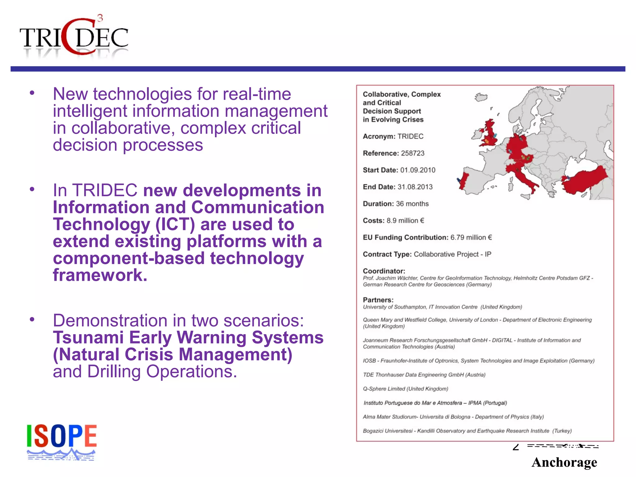
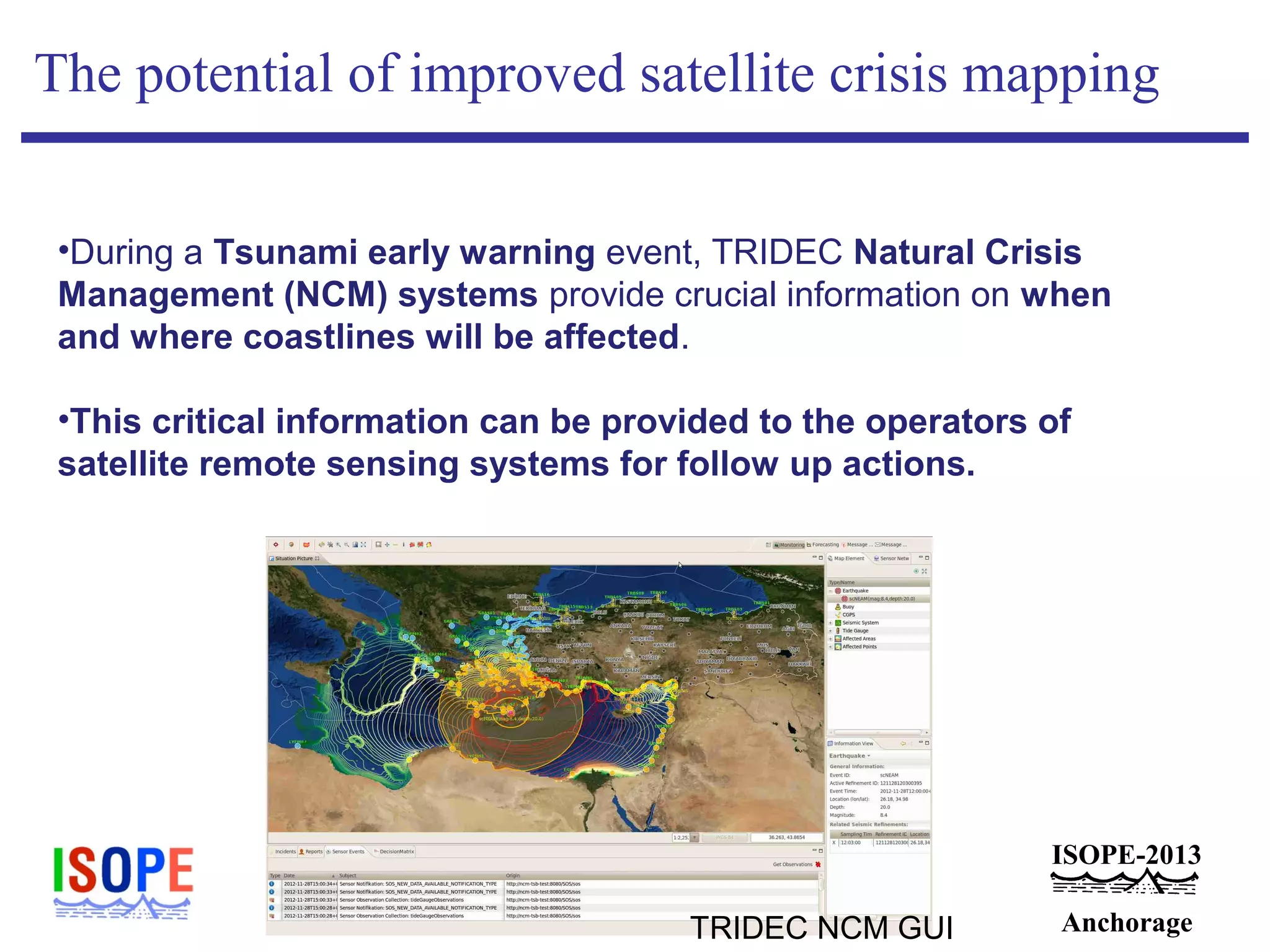
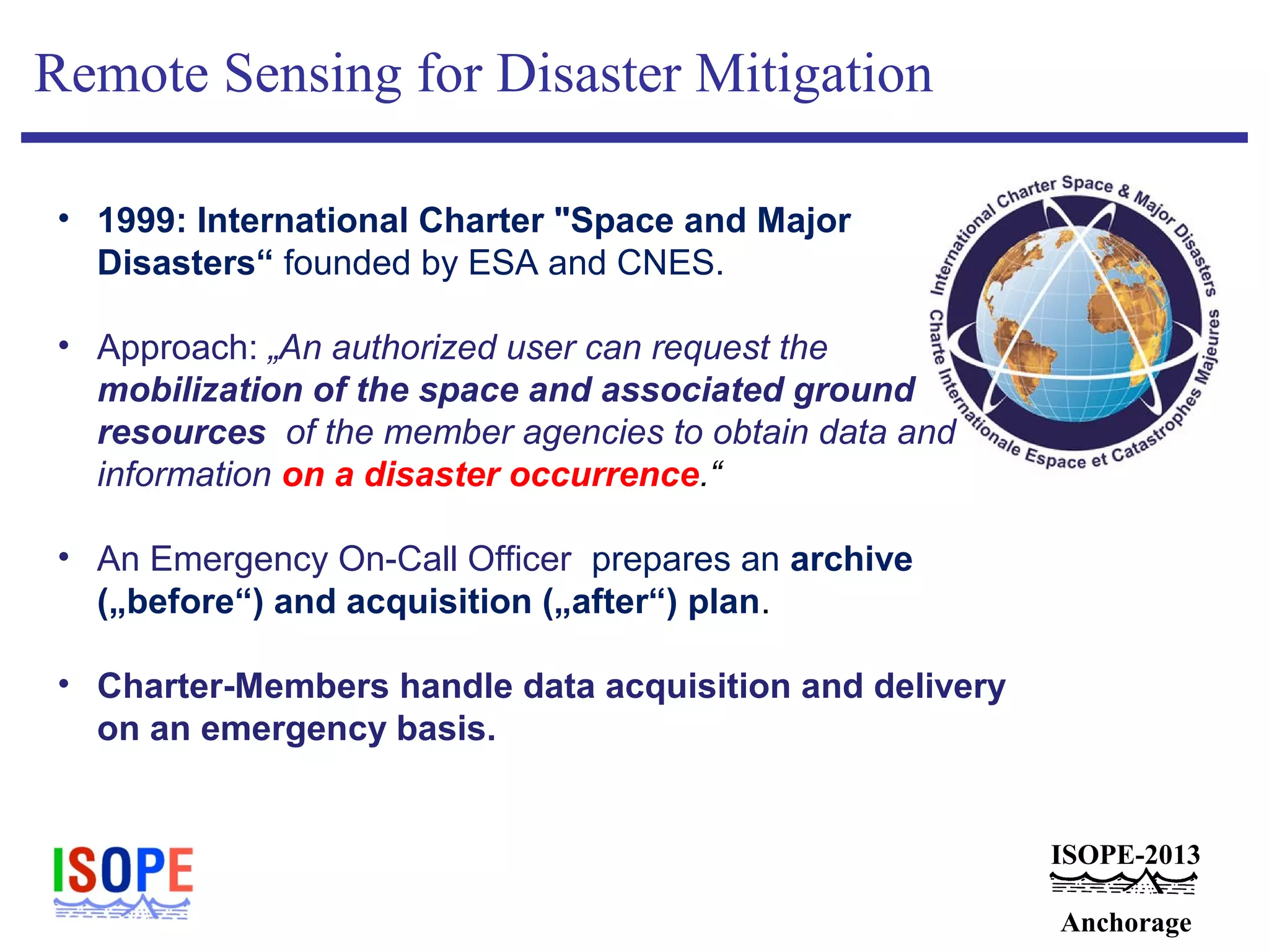
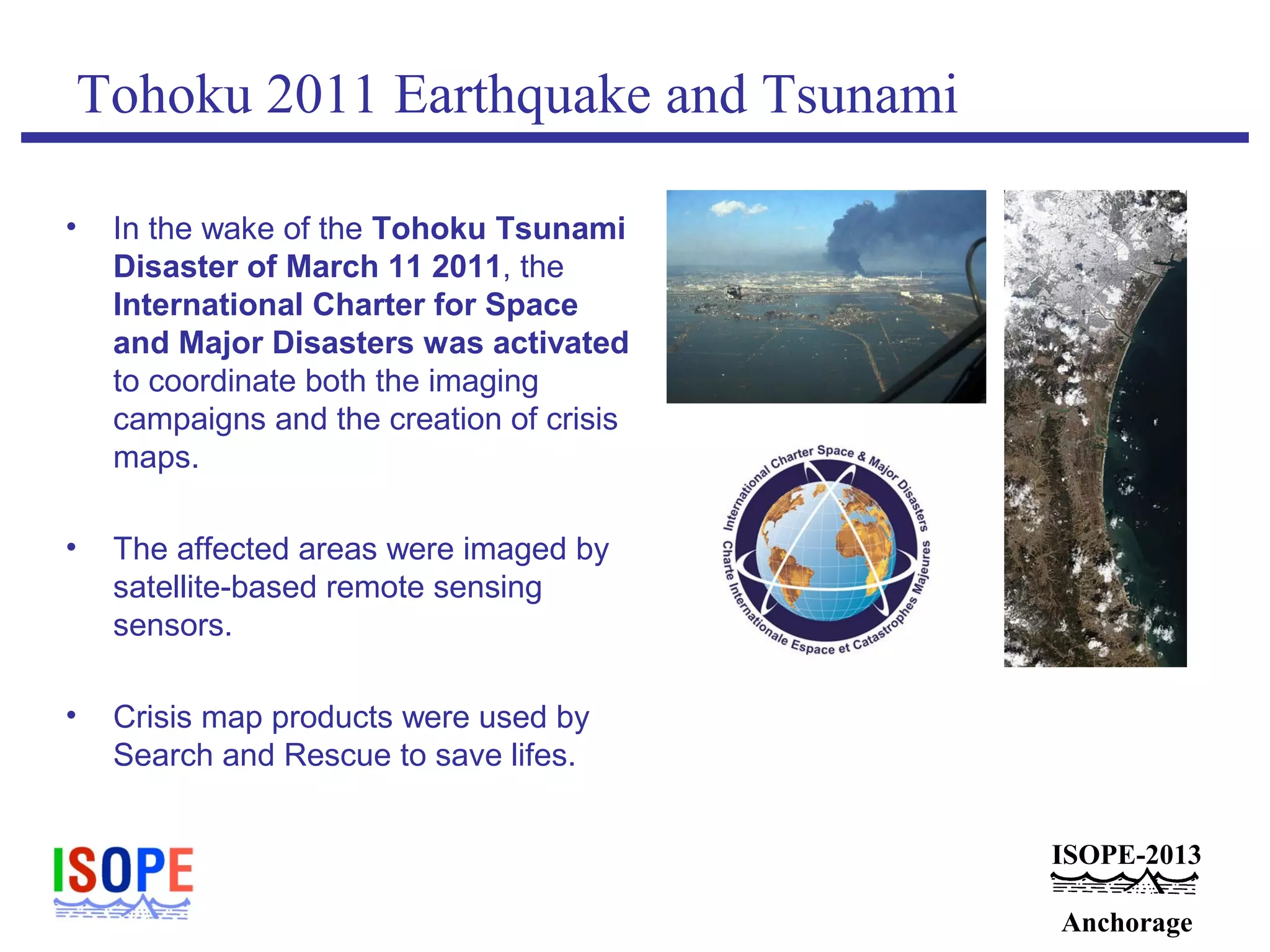
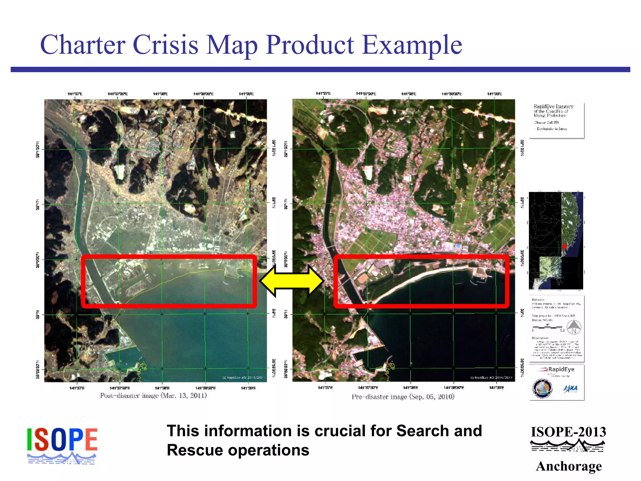
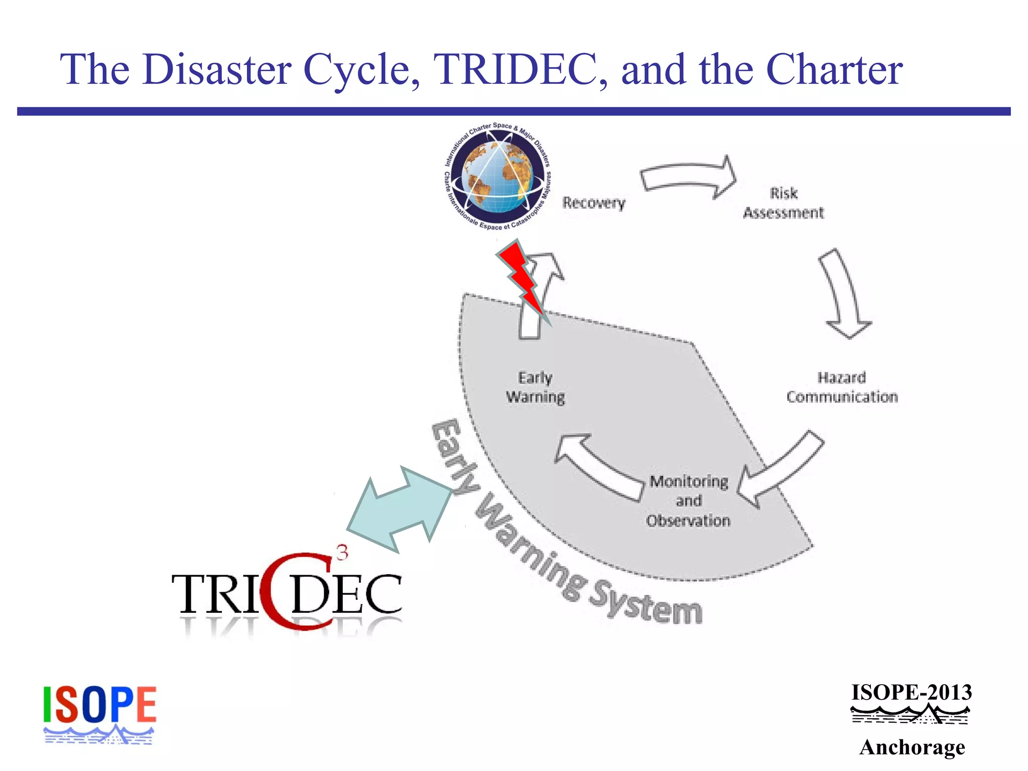
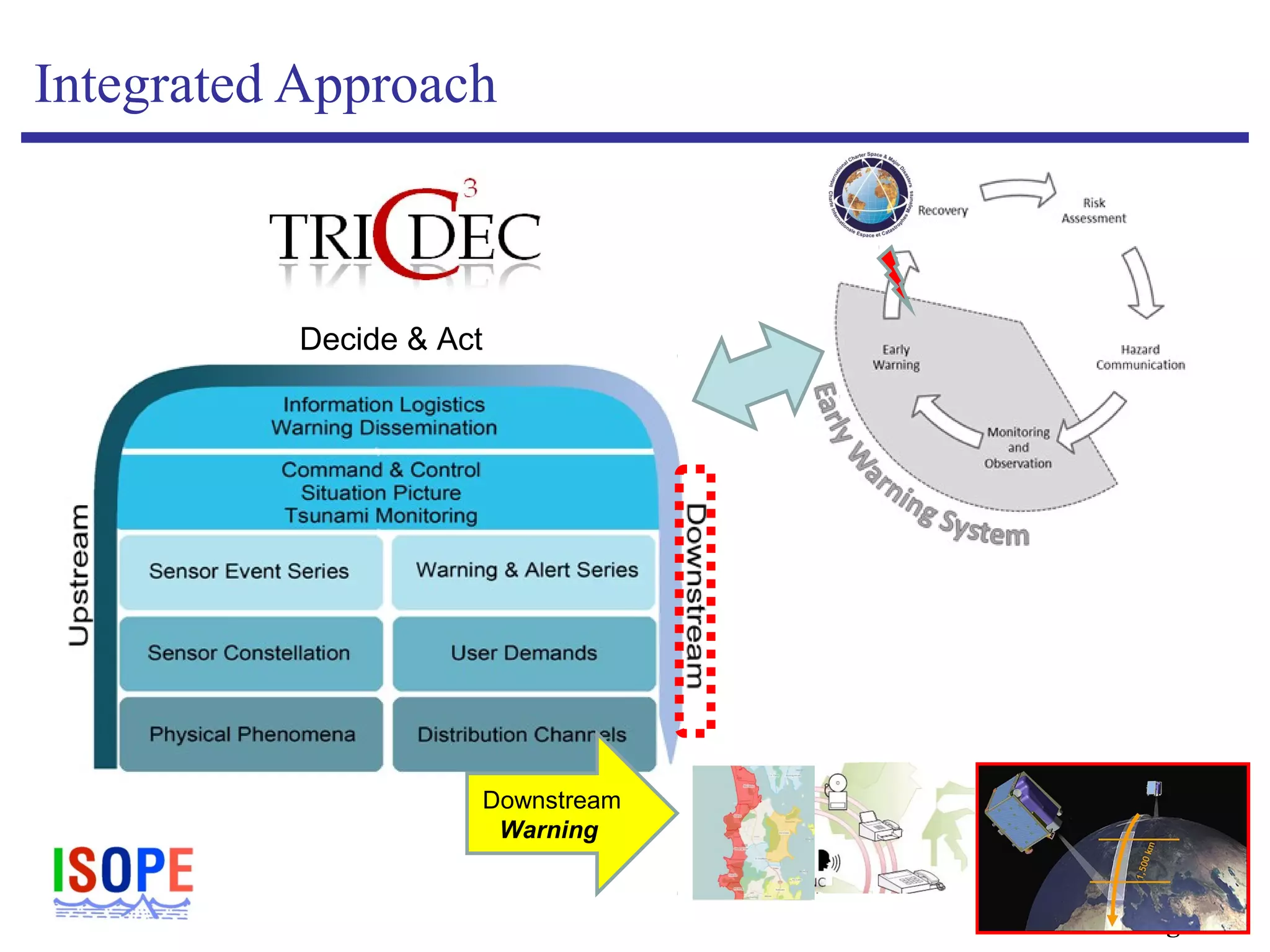
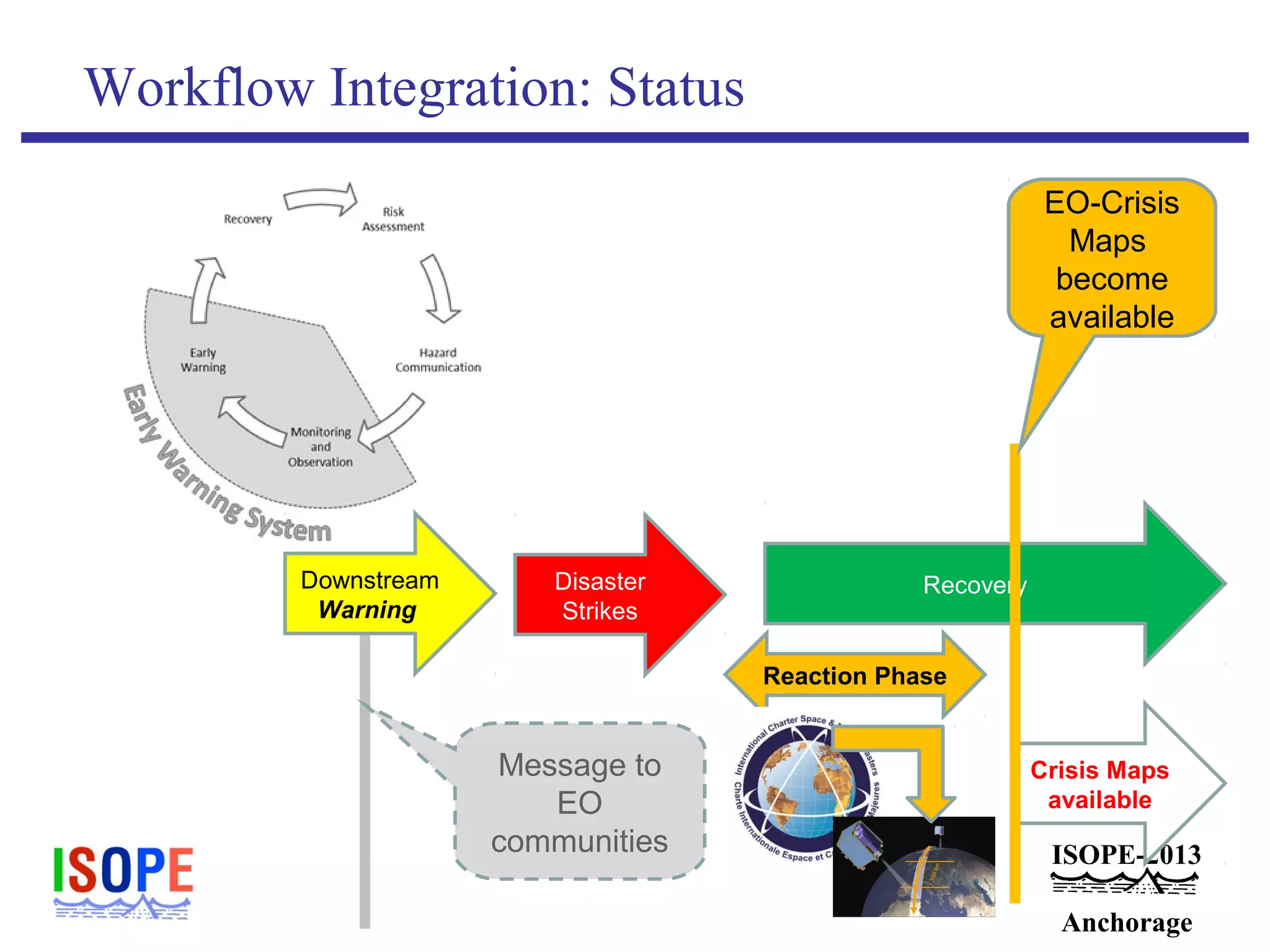
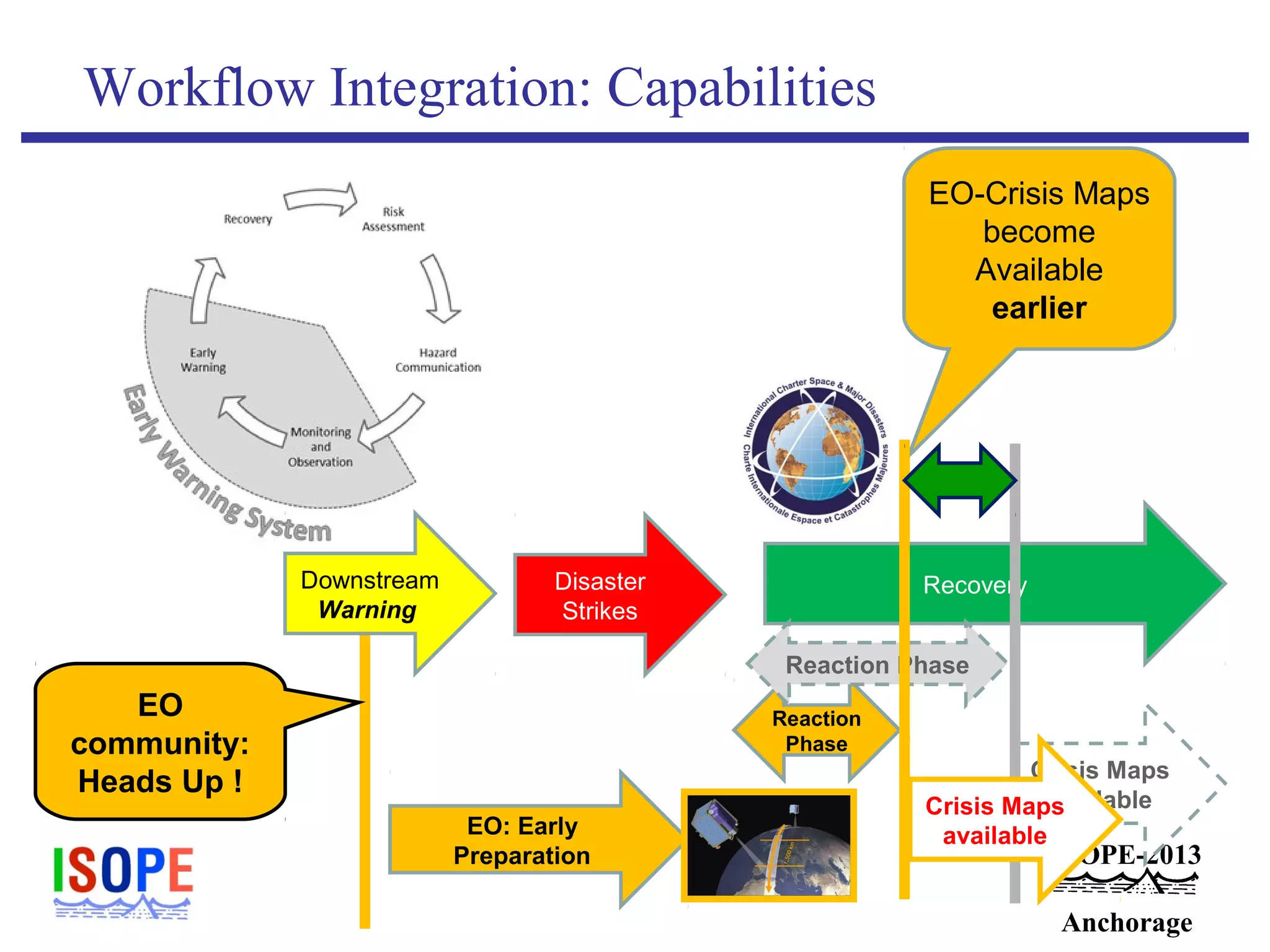
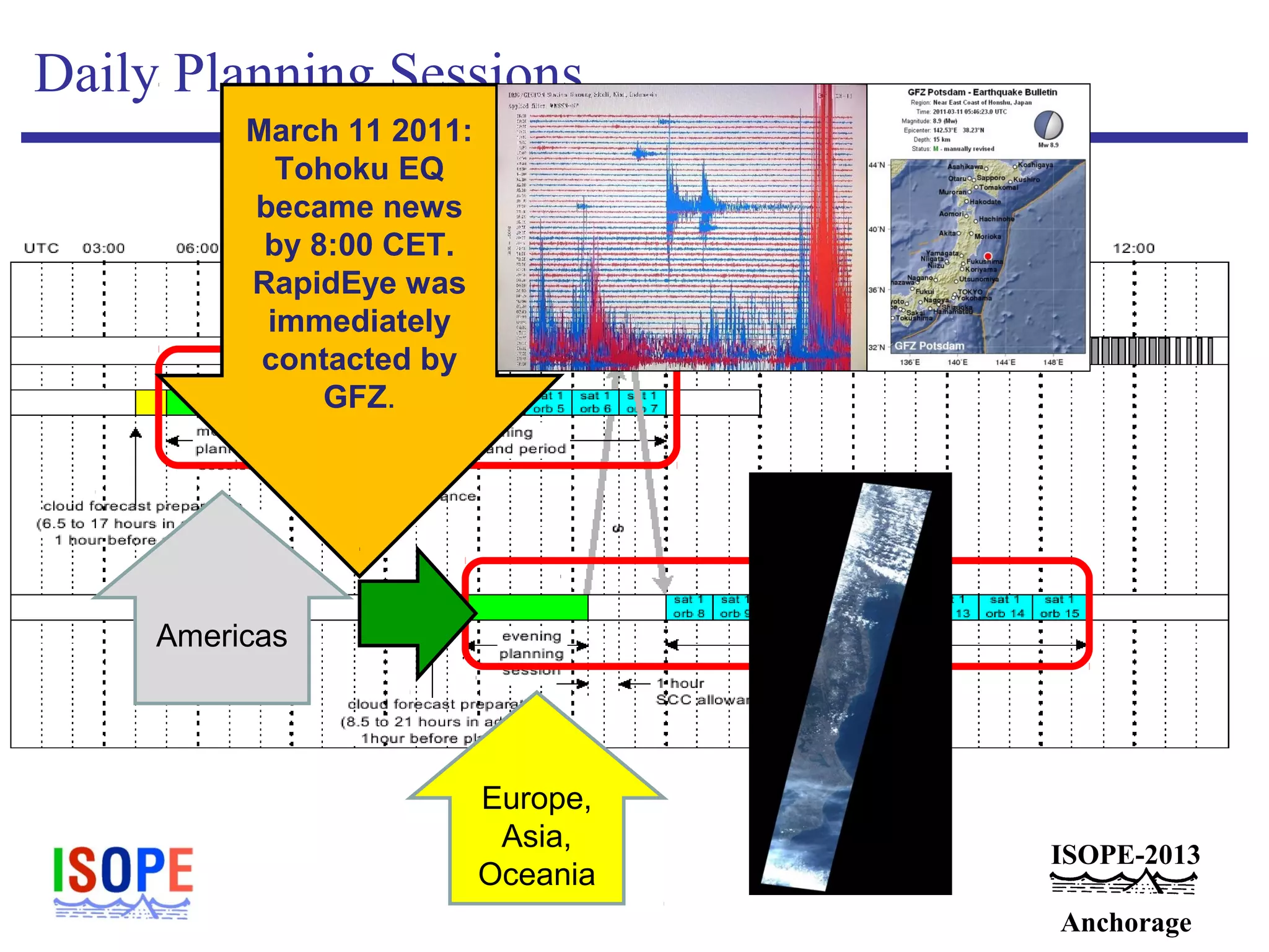
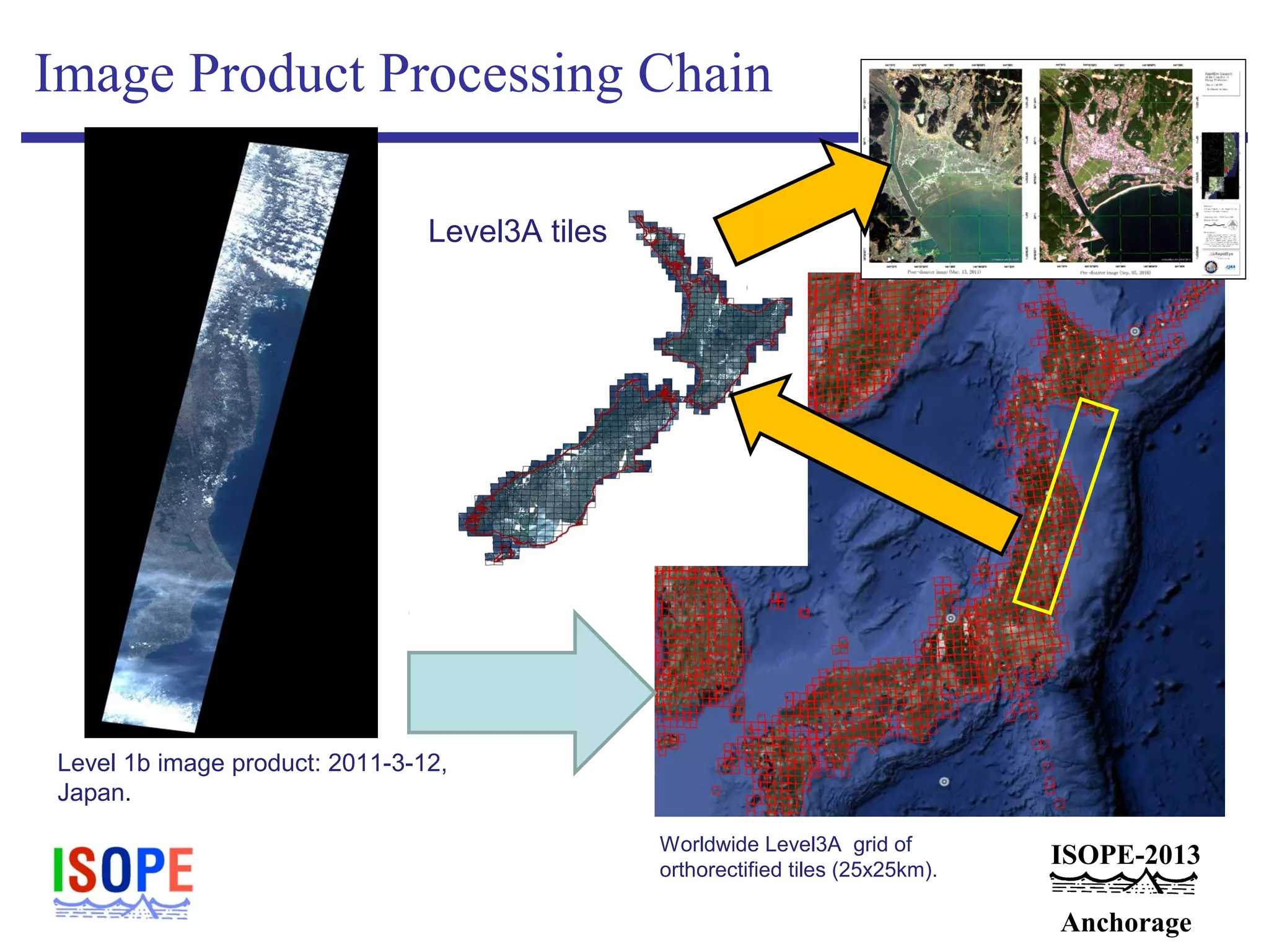
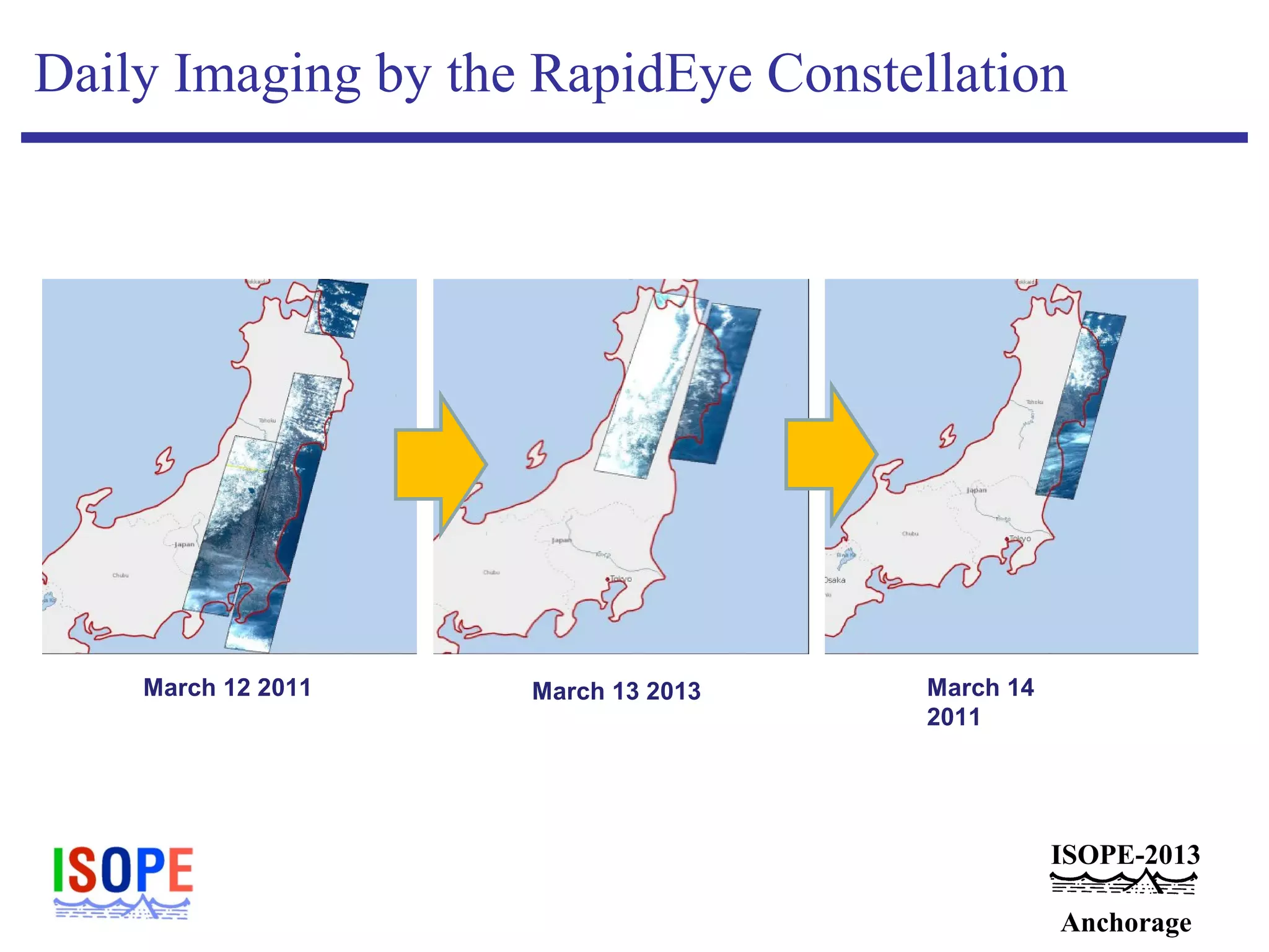
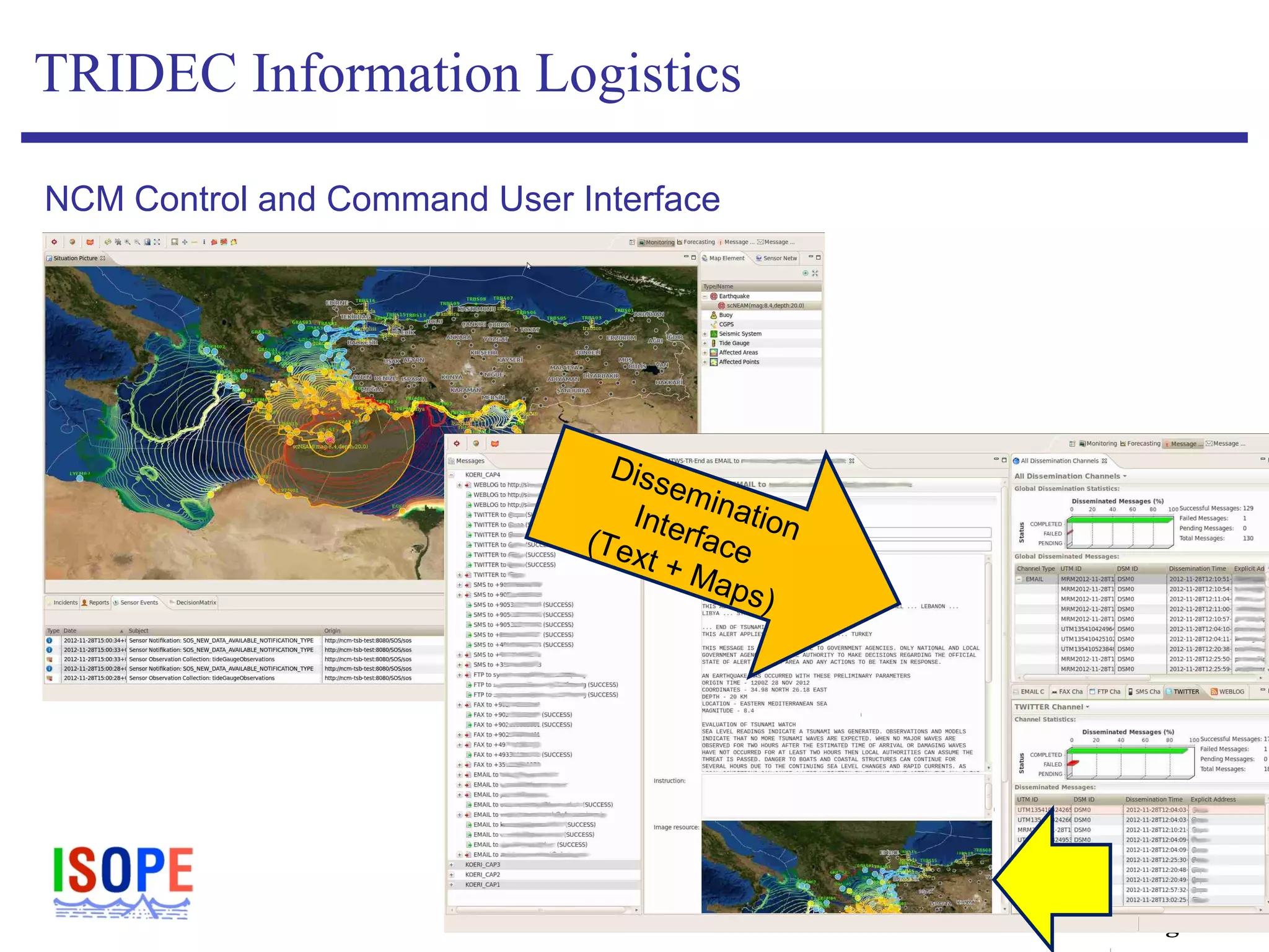
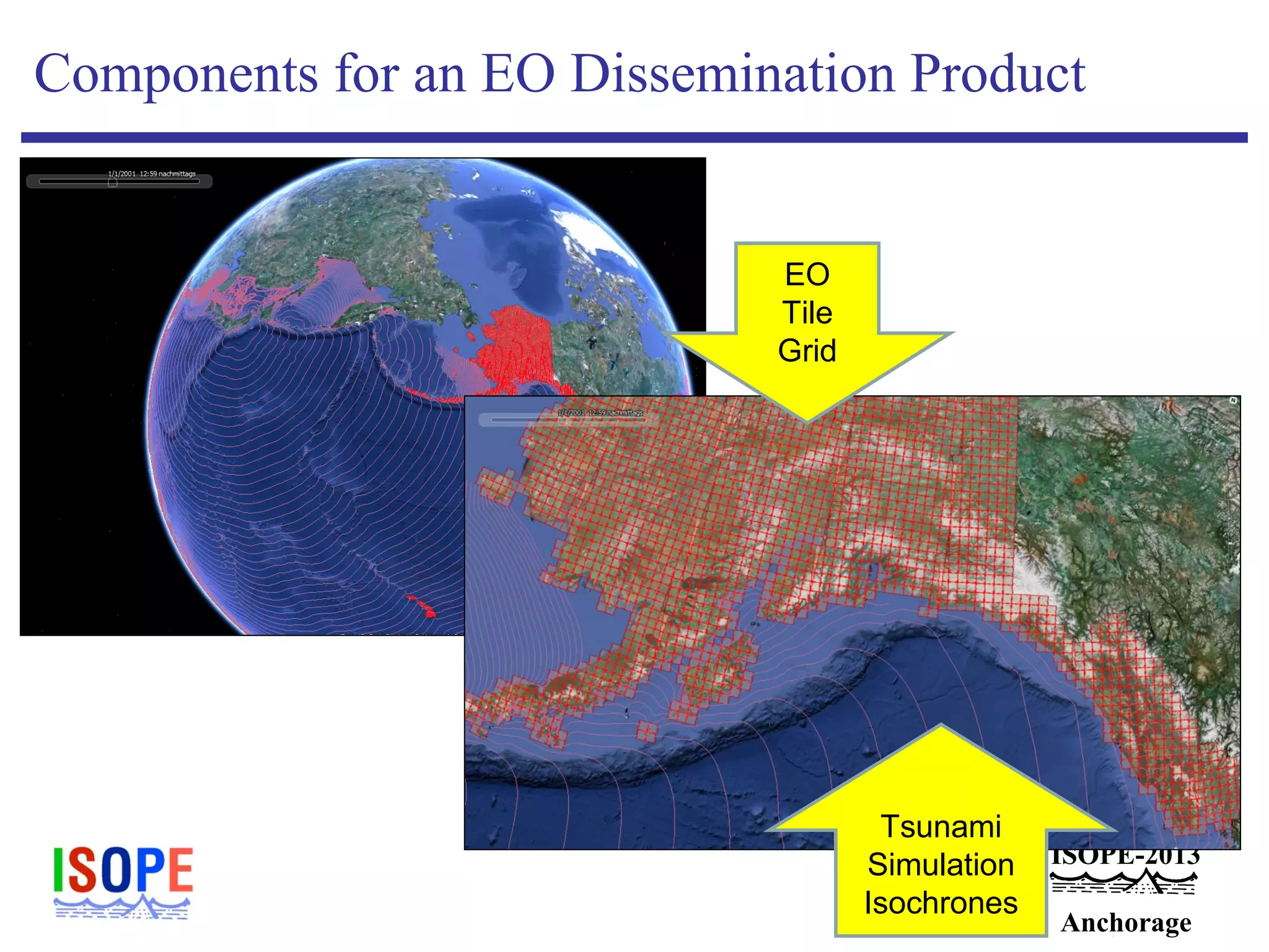
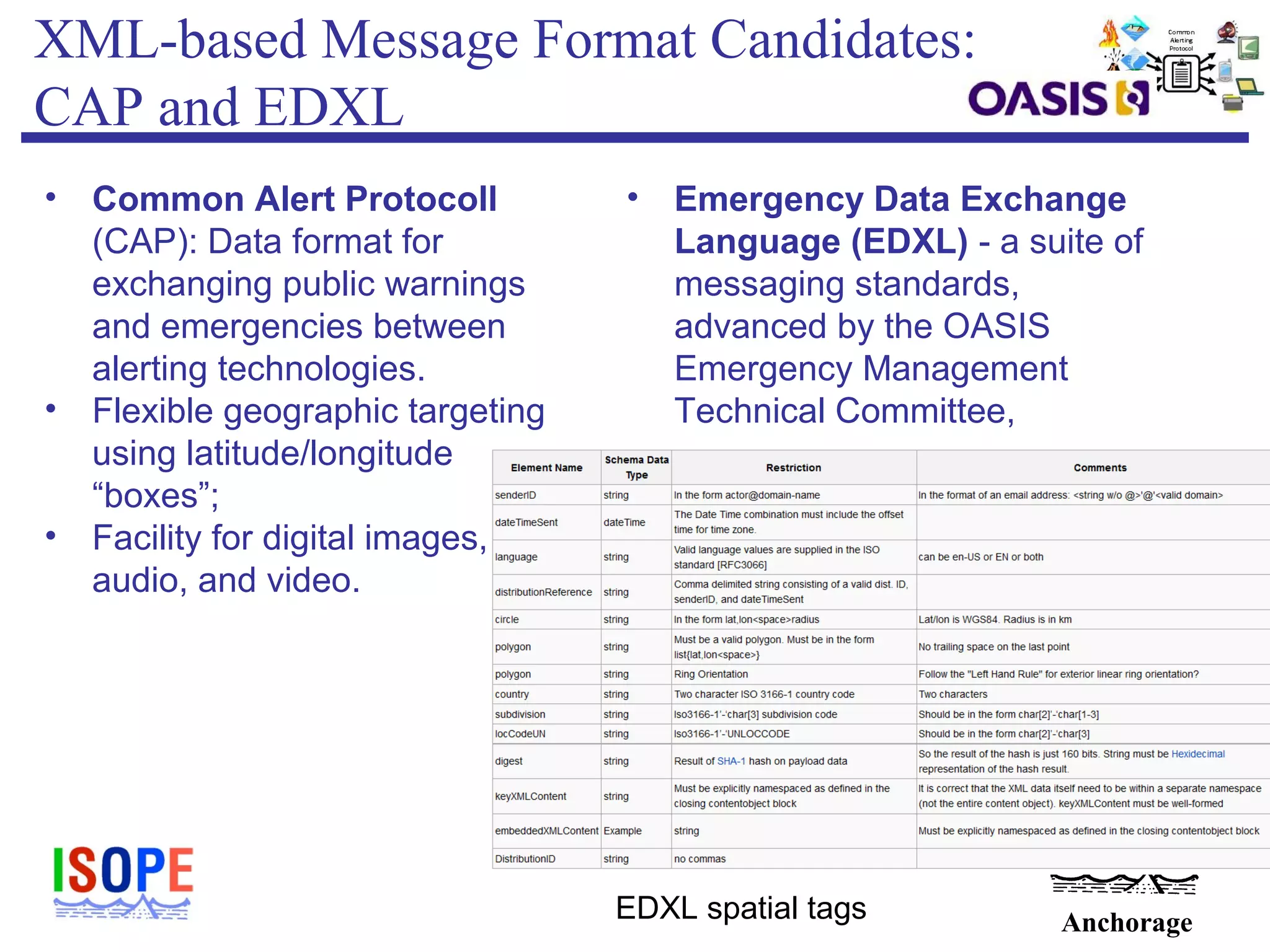
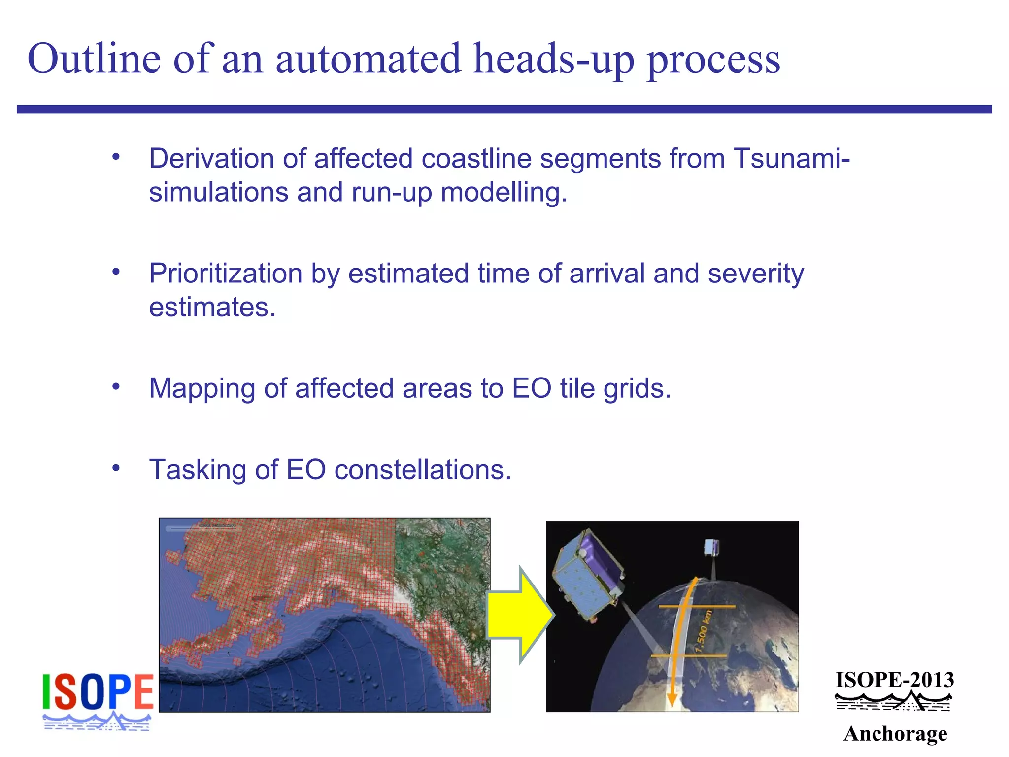
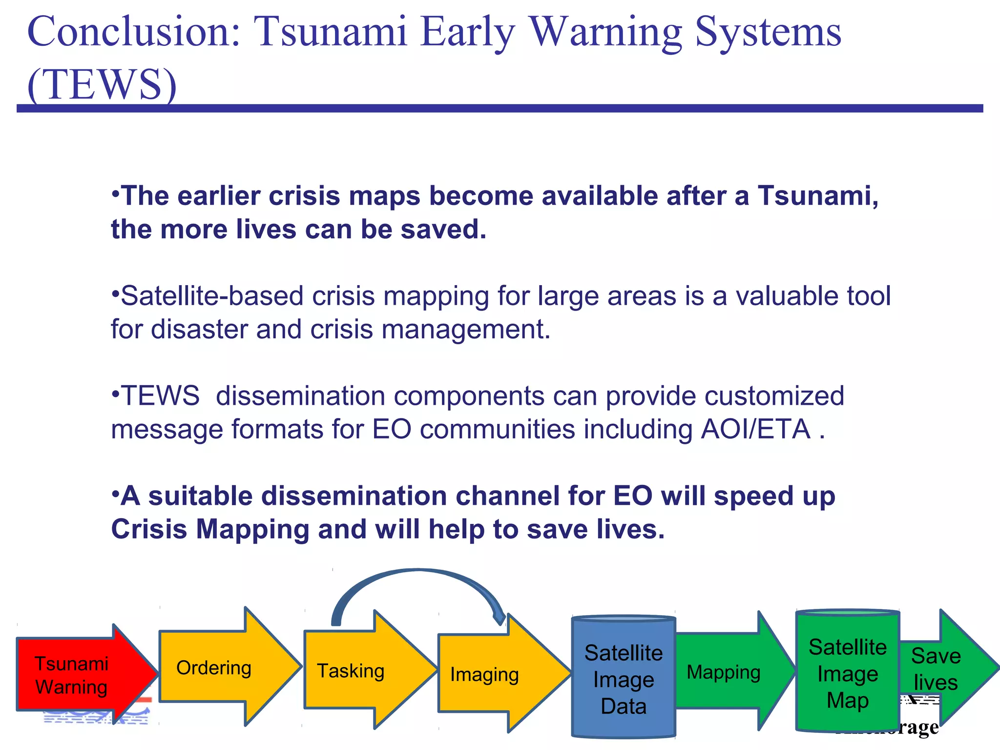
SlideShare a Scribd company logo
ISOPE-2013 Anchorage Conference
The 23rd International Ocean and Polar Engineering Conference
Anchorage, Alaska, USA, June 30−July 5, 2013: www.isope.org; www.isope2013.org
Mapping the Tohoku 2011 Tsunami event
with a remote sensing satellite constellation
– a reference case for emerging Early Warning System
Dissemination Services
Peter Löwe, Joachim Wächter
Centre for GeoinformationTechnology (CeGIT), GFZ
German Research Centre for Geosciences
Potsdam, Germany
ISOPE-2013
Anchorage
ISOPE-2013
Anchorage
TRIDEC
• New technologies for real time‐
intelligent information management
in collaborative, complex critical
decision processes
• In TRIDEC new developments in
Information and Communication
Technology (ICT) are used to
extend existing platforms with a
component-based technology
framework.
• Demonstration in two scenarios:
Tsunami Early Warning Systems
(Natural Crisis Management)
and Drilling Operations.
2
ISOPE-2013
Anchorage
The potential of improved satellite crisis mapping
•During a Tsunami early warning event, TRIDEC Natural Crisis
Management (NCM) systems provide crucial information on when
and where coastlines will be affected.
•This critical information can be provided to the operators of
satellite remote sensing systems for follow up actions.
TRIDEC NCM GUI
ISOPE-2013
Anchorage
Remote Sensing for Disaster Mitigation
• 1999: International Charter "Space and Major
Disasters“ founded by ESA and CNES.
• Approach: „An authorized user can request the
mobilization of the space and associated ground
resources of the member agencies to obtain data and
information on a disaster occurrence.“
• An Emergency On-Call Officer prepares an archive
(„before“) and acquisition („after“) plan.
• Charter-Members handle data acquisition and delivery
on an emergency basis.
ISOPE-2013
Anchorage
Tohoku 2011 Earthquake and Tsunami
• In the wake of the Tohoku Tsunami
Disaster of March 11 2011, the
International Charter for Space
and Major Disasters was activated
to coordinate both the imaging
campaigns and the creation of crisis
maps.
• The affected areas were imaged by
satellite-based remote sensing
sensors.
• Crisis map products were used by
Search and Rescue to save lifes.
ISOPE-2013
Anchorage
Charter Crisis Map Product Example
This information is crucial for Search and
Rescue operations
ISOPE-2013
Anchorage
The Disaster Cycle, TRIDEC, and the Charter
ISOPE-2013
Anchorage
ISOPE-2013
Anchorage
Integrated Approach
Decide & Act
Downstream
Warning
ISOPE-2013
Anchorage
Benefits from a EO dissemination channel
• Preparations for satellite imaging can begin before the tsunami
devastates an Area of Interest,
• reducing the time between tsunami landfall and first satellite
image take,
• speeding up production of crisis maps,
• enabling earlier and better coordinated response by
Search and Rescue (SAR),
• potenially allowing for before/after coverage.
ISOPE-2013
Anchorage
Workflow Integration: Status
Disaster
Strikes
Recovery
Reaction Phase
Crisis Maps
available
Message to
EO
communities
EO-Crisis
Maps
become
available
Downstream
Warning
ISOPE-2013
Anchorage
Workflow Integration: Capabilities
Disaster
Strikes
Recovery
Reaction
Phase
Crisis Maps
available
EO
community:
Heads Up !
EO-Crisis Maps
become
Available
earlier
Downstream
Warning
EO: Early
Preparation
Reaction Phase
Crisis Maps
available
ISOPE-2013
Anchorage
Evolution of Earth Observation Systems
Core parameters for satellite-based remote sensing:
• Spatial/spectral resolution („Pixel size“ of sensor)
• Temporal resolution (Revisit rate: „Number of satellites“)
•Single satellite
• Pace for image acquisition planning: Weeks / Days
•Constellations of several satellites in one orbit plane
• Pace: Day(s) / Hours
•Multiple Constellations in multiple orbit planes (upcoming)
• Pace: Hours / Minutes
ISOPE-2013
Anchorage
Workflow Integration: Status
•Currently, Tsunami Early Warning only considers bullets 2 and 3.
•Tsunami Early Warning must provide Tsunami Information (bullet 1) to
start the image acquisition process (orange)
Satellite
Image
Data
Save
lives
MappingTaskingOrderingTsunami
Warning
Imaging
Satellite
Image
Map
1 2 3
ISOPE-2013
Anchorage
Earth Observation: Planning and Tasking
• Operators of remote sensing satellites operate a planning and
tasking/commandeering cycle to control image acquisition.
• Planning: Arrange and prioritize image orders by
• Area of Interest (AOI)
• Time of Interest (TOI)
• Optical Sensors: Cloud Forecast Constraints
• Other Factors: Urgency, on-board memory availability, power,
etc.
• Tasking: Setting of an imaging schedule.
• Commandeering: Upload of imaging schedule to sensors + execution.
ISOPE-2013
Anchorage
Case Study: Rapid Eye Constellation
• Commercially operated constellation of five
satellites
• Charter Member
• Disaster Mapping since 2009
Summer 2013; Flooding in Central
Europe
ISOPE-2013
Anchorage
Example: The RapidEye Satellite Constellation
• Constellation operational since February 2009
• Five identical optical remote sensing satellites
• ~ 630km above ground
• ~ 90 minutes orbit period
• Sun-synchronous (overpass 11:30 a.m. local time)
Images: RapidEye
ISOPE-2013
Anchorage
RapidEye: Optical Imaging Sensors
•Five spectral bands: red / green / blue / red-edge / near-infrared
•Resolution of data products: 5m*5m pixel.
•Swath width: 77 km
•Max. swath length: 1200 km
Egypt 2010 Image: RapidEye AG
Example: Anchorage
ISOPE-2013
Anchorage
Example: Order Planning/Tasking/Execution
The timeline reflects the RapidEye “Two plannings per day” scenario.
10h – 25h
Daily Deadlines
Order turnaround time
Source: Hoja et al.: Optimised Near-Real Time Data Acquisition and
Pre- processing of Satellite Data for Disaster Related Rapid Mapping :
PFG2010/6,429-438
ISOPE-2013
Anchorage
Daily Planning Sessions
Europe,
Asia,
Oceania
Americas
ISOPE-2013
Anchorage
Daily Planning Sessions
Europe,
Asia,
Oceania
Americas
March 11 2011:
Tohoku EQ
became news
by 8:00 CET.
RapidEye was
immediately
contacted by
GFZ.
ISOPE-2013
Anchorage
Image Product Processing Chain
Worldwide Level3A grid of
orthorectified tiles (25x25km).
Level 1b image product: 2011-3-12,
Japan.
Crisis Mapping Product
Level3A tiles
ISOPE-2013
Anchorage
Daily Imaging by the RapidEye Constellation
March 12 2011 March 13 2013 March 14
2011
ISOPE-2013
Anchorage
Use of Volunteered Geographic Information by
the EO Community
• Gulf of Mexico Oilspill 2010
• Louisiana Bucket Brigade
• Ushahidi Open Source Social
Mapping
Before
Ushahidi/Bucket Brigade: Oil
residue found on beach
Confirmation by EO
ISOPE-2013
Anchorage
TRIDEC Information Logistics
NCM Control and Command User Interface
DisseminationInterface(Text + Maps)
ISOPE-2013
Anchorage
Components for an EO Dissemination Product
EO
Tile
Grid
Tsunami
Simulation
Isochrones
ISOPE-2013
Anchorage
XML-based Message Format Candidates:
CAP and EDXL
• Common Alert Protocoll
(CAP): Data format for
exchanging public warnings
and emergencies between
alerting technologies.
• Flexible geographic targeting
using latitude/longitude
“boxes”;
• Facility for digital images,
audio, and video.
• Emergency Data Exchange
Language (EDXL) - a suite of
messaging standards,
advanced by the OASIS
Emergency Management
Technical Committee,
EDXL spatial tags
ISOPE-2013
Anchorage
Outline of an automated heads-up process
• Derivation of affected coastline segments from Tsunami-
simulations and run-up modelling.
• Prioritization by estimated time of arrival and severity
estimates.
• Mapping of affected areas to EO tile grids.
• Tasking of EO constellations.
ISOPE-2013
Anchorage
Conclusion: EO Operators Perspective
Benefits from dedicated EO warning services:
•Preparation for short term crisis mapping ahead of time
•Image acquisition as early as possible
•Larger data stock
•Increased business opportunities
ISOPE-2013
Anchorage
Conclusion: Tsunami Early Warning Systems
(TEWS)
•The earlier crisis maps become available after a Tsunami,
the more lives can be saved.
•Satellite-based crisis mapping for large areas is a valuable tool
for disaster and crisis management.
•TEWS dissemination components can provide customized
message formats for EO communities including AOI/ETA .
•A suitable dissemination channel for EO will speed up
Crisis Mapping and will help to save lives.
Satellite
Image
Data
Save
lives
MappingTaskingOrderingTsunami
Warning
Imaging
Satellite
Image
Map
ISOPE-2013
Anchorage
Thank you very much

More Related Content

What's hot

Thailand Earth Observation System sattellite
Thailand Earth Observation System sattelliteThailand Earth Observation System sattellite
Thailand Earth Observation System sattellite
Phongsakorn Uar-amrungkoon
 
Collection and Interpretation of Remote Sensing Data, Kasper Johansen, Univer...
Collection and Interpretation of Remote Sensing Data, Kasper Johansen, Univer...Collection and Interpretation of Remote Sensing Data, Kasper Johansen, Univer...
Collection and Interpretation of Remote Sensing Data, Kasper Johansen, Univer...becnicholas
 
GWT 2014: Emergency Conference - 08 I servizi satellitari in near real-time a...
GWT 2014: Emergency Conference - 08 I servizi satellitari in near real-time a...GWT 2014: Emergency Conference - 08 I servizi satellitari in near real-time a...
GWT 2014: Emergency Conference - 08 I servizi satellitari in near real-time a...
Planetek Italia Srl
 
Dario izzo - grand jupiter tour
Dario izzo - grand jupiter tourDario izzo - grand jupiter tour
Dario izzo - grand jupiter tour
Advanced-Concepts-Team
 
Module 10 - Section 4: ICTs for understanding and monitoring the environment ...
Module 10 - Section 4: ICTs for understanding and monitoring the environment ...Module 10 - Section 4: ICTs for understanding and monitoring the environment ...
Module 10 - Section 4: ICTs for understanding and monitoring the environment ...
Richard Labelle
 
REVIEW OF TRACKING METHODOLOGIES FOR PHOTOVOLTAIC (PV) PANELS
REVIEW OF TRACKING METHODOLOGIES FOR PHOTOVOLTAIC (PV) PANELSREVIEW OF TRACKING METHODOLOGIES FOR PHOTOVOLTAIC (PV) PANELS
REVIEW OF TRACKING METHODOLOGIES FOR PHOTOVOLTAIC (PV) PANELS
UKOIMA KELVIN MNSE, MNIEEE
 
Remote sensing and gps
Remote sensing and gpsRemote sensing and gps
Remote sensing and gps
msfbi1521
 
Environmental Remote Sensing
 Environmental Remote Sensing  Environmental Remote Sensing
Environmental Remote Sensing
Ghassan Hadi
 
Remote sensing overview
Remote sensing overviewRemote sensing overview
Remote sensing overview
SVKM'S IOT DHULE
 
Esa act talk
Esa act talkEsa act talk
Remote sensing concept and applications
Remote sensing   concept and applicationsRemote sensing   concept and applications
Remote sensing concept and applications
Megha Majoe
 
GEO Grid災害タスクフォース 〜東日本大震災における活動〜 GIS学会2011
GEO Grid災害タスクフォース 〜東日本大震災における活動〜 GIS学会2011GEO Grid災害タスクフォース 〜東日本大震災における活動〜 GIS学会2011
GEO Grid災害タスクフォース 〜東日本大震災における活動〜 GIS学会2011Naotaka YAMAMOTO CHIKASADA
 
Irsolav Methodology 2013
Irsolav Methodology 2013Irsolav Methodology 2013
Irsolav Methodology 2013
IrSOLaV Pomares
 
A Study on the Development of High Accuracy Solar Tracking Systems
A Study on the Development of High Accuracy Solar Tracking SystemsA Study on the Development of High Accuracy Solar Tracking Systems
A Study on the Development of High Accuracy Solar Tracking Systemsiskandaruz
 
Remote sensing
Remote sensing   Remote sensing
Remote sensing
kalyanabooshnam
 
Lec_13_Introduction to Remote Sensing (RS)
Lec_13_Introduction to Remote Sensing (RS)Lec_13_Introduction to Remote Sensing (RS)
Lec_13_Introduction to Remote Sensing (RS)
Atiqa khan
 
Intelligent satellites
Intelligent satellitesIntelligent satellites
Intelligent satellitesClifford Stone
 
Application of Remote Sensing in Civil Engineering
Application of Remote Sensing in Civil EngineeringApplication of Remote Sensing in Civil Engineering
Application of Remote Sensing in Civil Engineering
IEI GSC
 

What's hot (20)

Thailand Earth Observation System sattellite
Thailand Earth Observation System sattelliteThailand Earth Observation System sattellite
Thailand Earth Observation System sattellite
 
Collection and Interpretation of Remote Sensing Data, Kasper Johansen, Univer...
Collection and Interpretation of Remote Sensing Data, Kasper Johansen, Univer...Collection and Interpretation of Remote Sensing Data, Kasper Johansen, Univer...
Collection and Interpretation of Remote Sensing Data, Kasper Johansen, Univer...
 
GWT 2014: Emergency Conference - 08 I servizi satellitari in near real-time a...
GWT 2014: Emergency Conference - 08 I servizi satellitari in near real-time a...GWT 2014: Emergency Conference - 08 I servizi satellitari in near real-time a...
GWT 2014: Emergency Conference - 08 I servizi satellitari in near real-time a...
 
Dario izzo - grand jupiter tour
Dario izzo - grand jupiter tourDario izzo - grand jupiter tour
Dario izzo - grand jupiter tour
 
Module 10 - Section 4: ICTs for understanding and monitoring the environment ...
Module 10 - Section 4: ICTs for understanding and monitoring the environment ...Module 10 - Section 4: ICTs for understanding and monitoring the environment ...
Module 10 - Section 4: ICTs for understanding and monitoring the environment ...
 
REVIEW OF TRACKING METHODOLOGIES FOR PHOTOVOLTAIC (PV) PANELS
REVIEW OF TRACKING METHODOLOGIES FOR PHOTOVOLTAIC (PV) PANELSREVIEW OF TRACKING METHODOLOGIES FOR PHOTOVOLTAIC (PV) PANELS
REVIEW OF TRACKING METHODOLOGIES FOR PHOTOVOLTAIC (PV) PANELS
 
Remote sensing and gps
Remote sensing and gpsRemote sensing and gps
Remote sensing and gps
 
Environmental Remote Sensing
 Environmental Remote Sensing  Environmental Remote Sensing
Environmental Remote Sensing
 
Remote sensing overview
Remote sensing overviewRemote sensing overview
Remote sensing overview
 
Esa act talk
Esa act talkEsa act talk
Esa act talk
 
Remote sensing concept and applications
Remote sensing   concept and applicationsRemote sensing   concept and applications
Remote sensing concept and applications
 
GEO Grid災害タスクフォース 〜東日本大震災における活動〜 GIS学会2011
GEO Grid災害タスクフォース 〜東日本大震災における活動〜 GIS学会2011GEO Grid災害タスクフォース 〜東日本大震災における活動〜 GIS学会2011
GEO Grid災害タスクフォース 〜東日本大震災における活動〜 GIS学会2011
 
Irsolav Methodology 2013
Irsolav Methodology 2013Irsolav Methodology 2013
Irsolav Methodology 2013
 
A Study on the Development of High Accuracy Solar Tracking Systems
A Study on the Development of High Accuracy Solar Tracking SystemsA Study on the Development of High Accuracy Solar Tracking Systems
A Study on the Development of High Accuracy Solar Tracking Systems
 
Goal andga oct01
Goal andga oct01Goal andga oct01
Goal andga oct01
 
Remote sensing
Remote sensing   Remote sensing
Remote sensing
 
In sar 1-1-2011
In sar 1-1-2011In sar 1-1-2011
In sar 1-1-2011
 
Lec_13_Introduction to Remote Sensing (RS)
Lec_13_Introduction to Remote Sensing (RS)Lec_13_Introduction to Remote Sensing (RS)
Lec_13_Introduction to Remote Sensing (RS)
 
Intelligent satellites
Intelligent satellitesIntelligent satellites
Intelligent satellites
 
Application of Remote Sensing in Civil Engineering
Application of Remote Sensing in Civil EngineeringApplication of Remote Sensing in Civil Engineering
Application of Remote Sensing in Civil Engineering
 

Similar to Mapping the Tohoku 2011 Tsunami event with a remote sensing satellite constellation – a reference case for emerging Early Warning System Dissemination Services

Standards and Oil Spill Response
Standards and Oil Spill ResponseStandards and Oil Spill Response
Standards and Oil Spill Response
George Percivall
 
The Evolution of Disaster Early Warning Systems in the TRIDEC Project
The Evolution of Disaster Early Warning Systems in the TRIDEC ProjectThe Evolution of Disaster Early Warning Systems in the TRIDEC Project
The Evolution of Disaster Early Warning Systems in the TRIDEC ProjectPeter Löwe
 
Common Approach for UAS Data Geoprocessing
Common Approach for UAS Data GeoprocessingCommon Approach for UAS Data Geoprocessing
Common Approach for UAS Data Geoprocessing
George Percivall
 
Application packaging and systematic processing in earth observation exploita...
Application packaging and systematic processing in earth observation exploita...Application packaging and systematic processing in earth observation exploita...
Application packaging and systematic processing in earth observation exploita...
terradue
 
SC7 Workshop 2: Space Data for Secure Societies
SC7 Workshop 2: Space Data for Secure SocietiesSC7 Workshop 2: Space Data for Secure Societies
SC7 Workshop 2: Space Data for Secure Societies
BigData_Europe
 
The Evolution of Disaster Early Warning Systems in the TRIDEC Project
The Evolution of Disaster Early Warning Systems in the TRIDEC Project The Evolution of Disaster Early Warning Systems in the TRIDEC Project
The Evolution of Disaster Early Warning Systems in the TRIDEC Project
Peter Löwe
 
Disaster Risk Management ‘enlarged actions’ by Ivan Petiteville, co-chair, CE...
Disaster Risk Management ‘enlarged actions’ by Ivan Petiteville, co-chair, CE...Disaster Risk Management ‘enlarged actions’ by Ivan Petiteville, co-chair, CE...
Disaster Risk Management ‘enlarged actions’ by Ivan Petiteville, co-chair, CE...
Global Risk Forum GRFDavos
 
GEM’s hazard products: outcomes and applications
GEM’s hazard products: outcomes and applicationsGEM’s hazard products: outcomes and applications
GEM’s hazard products: outcomes and applications
Global Earthquake Model Foundation
 
Crowdsourcing the Acquisition and Analysis of Mobile Videos for Disaster Resp...
Crowdsourcing the Acquisition and Analysis of Mobile Videos for Disaster Resp...Crowdsourcing the Acquisition and Analysis of Mobile Videos for Disaster Resp...
Crowdsourcing the Acquisition and Analysis of Mobile Videos for Disaster Resp...
University of Southern California
 
C1.01: GOOS: an essential collaborative system enabling societal benefit - Jo...
C1.01: GOOS: an essential collaborative system enabling societal benefit - Jo...C1.01: GOOS: an essential collaborative system enabling societal benefit - Jo...
C1.01: GOOS: an essential collaborative system enabling societal benefit - Jo...
Blue Planet Symposium
 
2b intro num-cube_sat_v3
2b   intro num-cube_sat_v32b   intro num-cube_sat_v3
2b intro num-cube_sat_v3
GeoMedeelel
 
Preliminary Evaluation of TinyYOLO on a New Dataset for Search-And-Rescue wit...
Preliminary Evaluation of TinyYOLO on a New Dataset for Search-And-Rescue wit...Preliminary Evaluation of TinyYOLO on a New Dataset for Search-And-Rescue wit...
Preliminary Evaluation of TinyYOLO on a New Dataset for Search-And-Rescue wit...
Gennaro Vessio
 
An Automated Approach of Shoreline Detection Applied to Digital Videos using ...
An Automated Approach of Shoreline Detection Applied to Digital Videos using ...An Automated Approach of Shoreline Detection Applied to Digital Videos using ...
An Automated Approach of Shoreline Detection Applied to Digital Videos using ...
Dwi Putra Asana
 
GPS and its use in vehicle movement study in Earthquake Disaster Management
GPS and its use in vehicle movement study in Earthquake Disaster ManagementGPS and its use in vehicle movement study in Earthquake Disaster Management
GPS and its use in vehicle movement study in Earthquake Disaster Management
Mayur Rahangdale
 
EENA 2018 - Mapping Emergencies & Disasters
EENA 2018 - Mapping Emergencies & DisastersEENA 2018 - Mapping Emergencies & Disasters
EENA 2018 - Mapping Emergencies & Disasters
EENA (European Emergency Number Association)
 
C1.05: Sustained observations for many users - a perspective from Australia’s...
C1.05: Sustained observations for many users - a perspective from Australia’s...C1.05: Sustained observations for many users - a perspective from Australia’s...
C1.05: Sustained observations for many users - a perspective from Australia’s...
Blue Planet Symposium
 
Under water object classification using sonar signal
Under water object classification using sonar signalUnder water object classification using sonar signal
Under water object classification using sonar signal
IRJET Journal
 
Polar Use Case in ExtremeEarth-phiweek19
Polar Use Case in ExtremeEarth-phiweek19Polar Use Case in ExtremeEarth-phiweek19
Polar Use Case in ExtremeEarth-phiweek19
ExtremeEarth
 
Use of satellite imagery for the generation of an aquaculture atlas : a case ...
Use of satellite imagery for the generation of an aquaculture atlas : a case ...Use of satellite imagery for the generation of an aquaculture atlas : a case ...
Use of satellite imagery for the generation of an aquaculture atlas : a case ...
Blue BRIDGE
 
Time, Change and Habits in Geospatial-Temporal Information Standards
Time, Change and Habits in Geospatial-Temporal Information StandardsTime, Change and Habits in Geospatial-Temporal Information Standards
Time, Change and Habits in Geospatial-Temporal Information Standards
George Percivall
 

Similar to Mapping the Tohoku 2011 Tsunami event with a remote sensing satellite constellation – a reference case for emerging Early Warning System Dissemination Services (20)

Standards and Oil Spill Response
Standards and Oil Spill ResponseStandards and Oil Spill Response
Standards and Oil Spill Response
 
The Evolution of Disaster Early Warning Systems in the TRIDEC Project
The Evolution of Disaster Early Warning Systems in the TRIDEC ProjectThe Evolution of Disaster Early Warning Systems in the TRIDEC Project
The Evolution of Disaster Early Warning Systems in the TRIDEC Project
 
Common Approach for UAS Data Geoprocessing
Common Approach for UAS Data GeoprocessingCommon Approach for UAS Data Geoprocessing
Common Approach for UAS Data Geoprocessing
 
Application packaging and systematic processing in earth observation exploita...
Application packaging and systematic processing in earth observation exploita...Application packaging and systematic processing in earth observation exploita...
Application packaging and systematic processing in earth observation exploita...
 
SC7 Workshop 2: Space Data for Secure Societies
SC7 Workshop 2: Space Data for Secure SocietiesSC7 Workshop 2: Space Data for Secure Societies
SC7 Workshop 2: Space Data for Secure Societies
 
The Evolution of Disaster Early Warning Systems in the TRIDEC Project
The Evolution of Disaster Early Warning Systems in the TRIDEC Project The Evolution of Disaster Early Warning Systems in the TRIDEC Project
The Evolution of Disaster Early Warning Systems in the TRIDEC Project
 
Disaster Risk Management ‘enlarged actions’ by Ivan Petiteville, co-chair, CE...
Disaster Risk Management ‘enlarged actions’ by Ivan Petiteville, co-chair, CE...Disaster Risk Management ‘enlarged actions’ by Ivan Petiteville, co-chair, CE...
Disaster Risk Management ‘enlarged actions’ by Ivan Petiteville, co-chair, CE...
 
GEM’s hazard products: outcomes and applications
GEM’s hazard products: outcomes and applicationsGEM’s hazard products: outcomes and applications
GEM’s hazard products: outcomes and applications
 
Crowdsourcing the Acquisition and Analysis of Mobile Videos for Disaster Resp...
Crowdsourcing the Acquisition and Analysis of Mobile Videos for Disaster Resp...Crowdsourcing the Acquisition and Analysis of Mobile Videos for Disaster Resp...
Crowdsourcing the Acquisition and Analysis of Mobile Videos for Disaster Resp...
 
C1.01: GOOS: an essential collaborative system enabling societal benefit - Jo...
C1.01: GOOS: an essential collaborative system enabling societal benefit - Jo...C1.01: GOOS: an essential collaborative system enabling societal benefit - Jo...
C1.01: GOOS: an essential collaborative system enabling societal benefit - Jo...
 
2b intro num-cube_sat_v3
2b   intro num-cube_sat_v32b   intro num-cube_sat_v3
2b intro num-cube_sat_v3
 
Preliminary Evaluation of TinyYOLO on a New Dataset for Search-And-Rescue wit...
Preliminary Evaluation of TinyYOLO on a New Dataset for Search-And-Rescue wit...Preliminary Evaluation of TinyYOLO on a New Dataset for Search-And-Rescue wit...
Preliminary Evaluation of TinyYOLO on a New Dataset for Search-And-Rescue wit...
 
An Automated Approach of Shoreline Detection Applied to Digital Videos using ...
An Automated Approach of Shoreline Detection Applied to Digital Videos using ...An Automated Approach of Shoreline Detection Applied to Digital Videos using ...
An Automated Approach of Shoreline Detection Applied to Digital Videos using ...
 
GPS and its use in vehicle movement study in Earthquake Disaster Management
GPS and its use in vehicle movement study in Earthquake Disaster ManagementGPS and its use in vehicle movement study in Earthquake Disaster Management
GPS and its use in vehicle movement study in Earthquake Disaster Management
 
EENA 2018 - Mapping Emergencies & Disasters
EENA 2018 - Mapping Emergencies & DisastersEENA 2018 - Mapping Emergencies & Disasters
EENA 2018 - Mapping Emergencies & Disasters
 
C1.05: Sustained observations for many users - a perspective from Australia’s...
C1.05: Sustained observations for many users - a perspective from Australia’s...C1.05: Sustained observations for many users - a perspective from Australia’s...
C1.05: Sustained observations for many users - a perspective from Australia’s...
 
Under water object classification using sonar signal
Under water object classification using sonar signalUnder water object classification using sonar signal
Under water object classification using sonar signal
 
Polar Use Case in ExtremeEarth-phiweek19
Polar Use Case in ExtremeEarth-phiweek19Polar Use Case in ExtremeEarth-phiweek19
Polar Use Case in ExtremeEarth-phiweek19
 
Use of satellite imagery for the generation of an aquaculture atlas : a case ...
Use of satellite imagery for the generation of an aquaculture atlas : a case ...Use of satellite imagery for the generation of an aquaculture atlas : a case ...
Use of satellite imagery for the generation of an aquaculture atlas : a case ...
 
Time, Change and Habits in Geospatial-Temporal Information Standards
Time, Change and Habits in Geospatial-Temporal Information StandardsTime, Change and Habits in Geospatial-Temporal Information Standards
Time, Change and Habits in Geospatial-Temporal Information Standards
 

More from Peter Löwe

EGU GA 2018 OSGeo Townhall
EGU GA 2018 OSGeo TownhallEGU GA 2018 OSGeo Townhall
EGU GA 2018 OSGeo Townhall
Peter Löwe
 
EGU GA 2017 OSGeo Townhall
EGU GA 2017 OSGeo TownhallEGU GA 2017 OSGeo Townhall
EGU GA 2017 OSGeo Townhall
Peter Löwe
 
EGU GA 2014 OSGeo Townhall
EGU GA 2014 OSGeo TownhallEGU GA 2014 OSGeo Townhall
EGU GA 2014 OSGeo Townhall
Peter Löwe
 
EGU 2013 Splinter Meeting: FOSS in the Geosciences
EGU 2013 Splinter Meeting: FOSS in the Geosciences EGU 2013 Splinter Meeting: FOSS in the Geosciences
EGU 2013 Splinter Meeting: FOSS in the Geosciences
Peter Löwe
 
2012 egu foss_splinter_session
2012 egu foss_splinter_session2012 egu foss_splinter_session
2012 egu foss_splinter_session
Peter Löwe
 
INTEGRATION OPTIONS FOR PERSISTENT IDENTIFIERS IN OSGEO PROJECT REPOSITORIES:...
INTEGRATION OPTIONS FOR PERSISTENT IDENTIFIERS IN OSGEO PROJECT REPOSITORIES:...INTEGRATION OPTIONS FOR PERSISTENT IDENTIFIERS IN OSGEO PROJECT REPOSITORIES:...
INTEGRATION OPTIONS FOR PERSISTENT IDENTIFIERS IN OSGEO PROJECT REPOSITORIES:...
Peter Löwe
 
Research Data Management for Econometrics
Research Data Management for EconometricsResearch Data Management for Econometrics
Research Data Management for Econometrics
Peter Löwe
 
FOSSGIS 2015: Das audiovisuelle Erbe der OSGeo-Projekte
FOSSGIS 2015: Das audiovisuelle Erbe der OSGeo-ProjekteFOSSGIS 2015: Das audiovisuelle Erbe der OSGeo-Projekte
FOSSGIS 2015: Das audiovisuelle Erbe der OSGeo-Projekte
Peter Löwe
 
Unlocking conference videos by DOI/MFID for software project communities
Unlocking conference videos by DOI/MFID for software project communitiesUnlocking conference videos by DOI/MFID for software project communities
Unlocking conference videos by DOI/MFID for software project communities
Peter Löwe
 
Libraries in the Big Data Era: Strategies and Challenges in Archiving and Sha...
Libraries in the Big Data Era: Strategies and Challenges in Archiving and Sha...Libraries in the Big Data Era: Strategies and Challenges in Archiving and Sha...
Libraries in the Big Data Era: Strategies and Challenges in Archiving and Sha...
Peter Löwe
 
The TIB|AV Portal : OSGeo conference videos as a resource for scientific res...
The TIB|AV Portal : OSGeo conference videos as a resource for scientific res...The TIB|AV Portal : OSGeo conference videos as a resource for scientific res...
The TIB|AV Portal : OSGeo conference videos as a resource for scientific res...
Peter Löwe
 
TIB's action for research data managament as a national library's strategy in...
TIB's action for research data managament as a national library's strategy in...TIB's action for research data managament as a national library's strategy in...
TIB's action for research data managament as a national library's strategy in...
Peter Löwe
 
GIS Day 2015: Geoinformatics, Open Source and Videos - a library perspective
GIS Day 2015: Geoinformatics, Open Source and Videos - a library perspectiveGIS Day 2015: Geoinformatics, Open Source and Videos - a library perspective
GIS Day 2015: Geoinformatics, Open Source and Videos - a library perspective
Peter Löwe
 
GIS DAY 2015: Guerilla globes
GIS DAY 2015: Guerilla globes GIS DAY 2015: Guerilla globes
GIS DAY 2015: Guerilla globes
Peter Löwe
 
Acquisition of audiovisual Scientific Technical Information from OSGeo: A wor...
Acquisition of audiovisual Scientific Technical Information from OSGeo: A wor...Acquisition of audiovisual Scientific Technical Information from OSGeo: A wor...
Acquisition of audiovisual Scientific Technical Information from OSGeo: A wor...
Peter Löwe
 
First public screening of the high resolution version of the GRASS GIS video...
First public screening of the high resolution version of the  GRASS GIS video...First public screening of the high resolution version of the  GRASS GIS video...
First public screening of the high resolution version of the GRASS GIS video...Peter Löwe
 
GRASS GIS, Star Trek and old Video Tape – a reference case on audiovisual pre...
GRASS GIS, Star Trek and old Video Tape – a reference case on audiovisual pre...GRASS GIS, Star Trek and old Video Tape – a reference case on audiovisual pre...
GRASS GIS, Star Trek and old Video Tape – a reference case on audiovisual pre...
Peter Löwe
 
3D-printing with GRASS GIS – a work in progress in report FOSS4G 2014
3D-printing with GRASS GIS – a work in progress in report FOSS4G 20143D-printing with GRASS GIS – a work in progress in report FOSS4G 2014
3D-printing with GRASS GIS – a work in progress in report FOSS4G 2014
Peter Löwe
 
Tectonic Storytelling with Open Source and Digital Object Identifiers - a cas...
Tectonic Storytelling with Open Source and Digital Object Identifiers - a cas...Tectonic Storytelling with Open Source and Digital Object Identifiers - a cas...
Tectonic Storytelling with Open Source and Digital Object Identifiers - a cas...
Peter Löwe
 
Data Science: History repeated? – The heritage of the Free and Open Source GI...
Data Science: History repeated? – The heritage of the Free and Open Source GI...Data Science: History repeated? – The heritage of the Free and Open Source GI...
Data Science: History repeated? – The heritage of the Free and Open Source GI...
Peter Löwe
 

More from Peter Löwe (20)

EGU GA 2018 OSGeo Townhall
EGU GA 2018 OSGeo TownhallEGU GA 2018 OSGeo Townhall
EGU GA 2018 OSGeo Townhall
 
EGU GA 2017 OSGeo Townhall
EGU GA 2017 OSGeo TownhallEGU GA 2017 OSGeo Townhall
EGU GA 2017 OSGeo Townhall
 
EGU GA 2014 OSGeo Townhall
EGU GA 2014 OSGeo TownhallEGU GA 2014 OSGeo Townhall
EGU GA 2014 OSGeo Townhall
 
EGU 2013 Splinter Meeting: FOSS in the Geosciences
EGU 2013 Splinter Meeting: FOSS in the Geosciences EGU 2013 Splinter Meeting: FOSS in the Geosciences
EGU 2013 Splinter Meeting: FOSS in the Geosciences
 
2012 egu foss_splinter_session
2012 egu foss_splinter_session2012 egu foss_splinter_session
2012 egu foss_splinter_session
 
INTEGRATION OPTIONS FOR PERSISTENT IDENTIFIERS IN OSGEO PROJECT REPOSITORIES:...
INTEGRATION OPTIONS FOR PERSISTENT IDENTIFIERS IN OSGEO PROJECT REPOSITORIES:...INTEGRATION OPTIONS FOR PERSISTENT IDENTIFIERS IN OSGEO PROJECT REPOSITORIES:...
INTEGRATION OPTIONS FOR PERSISTENT IDENTIFIERS IN OSGEO PROJECT REPOSITORIES:...
 
Research Data Management for Econometrics
Research Data Management for EconometricsResearch Data Management for Econometrics
Research Data Management for Econometrics
 
FOSSGIS 2015: Das audiovisuelle Erbe der OSGeo-Projekte
FOSSGIS 2015: Das audiovisuelle Erbe der OSGeo-ProjekteFOSSGIS 2015: Das audiovisuelle Erbe der OSGeo-Projekte
FOSSGIS 2015: Das audiovisuelle Erbe der OSGeo-Projekte
 
Unlocking conference videos by DOI/MFID for software project communities
Unlocking conference videos by DOI/MFID for software project communitiesUnlocking conference videos by DOI/MFID for software project communities
Unlocking conference videos by DOI/MFID for software project communities
 
Libraries in the Big Data Era: Strategies and Challenges in Archiving and Sha...
Libraries in the Big Data Era: Strategies and Challenges in Archiving and Sha...Libraries in the Big Data Era: Strategies and Challenges in Archiving and Sha...
Libraries in the Big Data Era: Strategies and Challenges in Archiving and Sha...
 
The TIB|AV Portal : OSGeo conference videos as a resource for scientific res...
The TIB|AV Portal : OSGeo conference videos as a resource for scientific res...The TIB|AV Portal : OSGeo conference videos as a resource for scientific res...
The TIB|AV Portal : OSGeo conference videos as a resource for scientific res...
 
TIB's action for research data managament as a national library's strategy in...
TIB's action for research data managament as a national library's strategy in...TIB's action for research data managament as a national library's strategy in...
TIB's action for research data managament as a national library's strategy in...
 
GIS Day 2015: Geoinformatics, Open Source and Videos - a library perspective
GIS Day 2015: Geoinformatics, Open Source and Videos - a library perspectiveGIS Day 2015: Geoinformatics, Open Source and Videos - a library perspective
GIS Day 2015: Geoinformatics, Open Source and Videos - a library perspective
 
GIS DAY 2015: Guerilla globes
GIS DAY 2015: Guerilla globes GIS DAY 2015: Guerilla globes
GIS DAY 2015: Guerilla globes
 
Acquisition of audiovisual Scientific Technical Information from OSGeo: A wor...
Acquisition of audiovisual Scientific Technical Information from OSGeo: A wor...Acquisition of audiovisual Scientific Technical Information from OSGeo: A wor...
Acquisition of audiovisual Scientific Technical Information from OSGeo: A wor...
 
First public screening of the high resolution version of the GRASS GIS video...
First public screening of the high resolution version of the  GRASS GIS video...First public screening of the high resolution version of the  GRASS GIS video...
First public screening of the high resolution version of the GRASS GIS video...
 
GRASS GIS, Star Trek and old Video Tape – a reference case on audiovisual pre...
GRASS GIS, Star Trek and old Video Tape – a reference case on audiovisual pre...GRASS GIS, Star Trek and old Video Tape – a reference case on audiovisual pre...
GRASS GIS, Star Trek and old Video Tape – a reference case on audiovisual pre...
 
3D-printing with GRASS GIS – a work in progress in report FOSS4G 2014
3D-printing with GRASS GIS – a work in progress in report FOSS4G 20143D-printing with GRASS GIS – a work in progress in report FOSS4G 2014
3D-printing with GRASS GIS – a work in progress in report FOSS4G 2014
 
Tectonic Storytelling with Open Source and Digital Object Identifiers - a cas...
Tectonic Storytelling with Open Source and Digital Object Identifiers - a cas...Tectonic Storytelling with Open Source and Digital Object Identifiers - a cas...
Tectonic Storytelling with Open Source and Digital Object Identifiers - a cas...
 
Data Science: History repeated? – The heritage of the Free and Open Source GI...
Data Science: History repeated? – The heritage of the Free and Open Source GI...Data Science: History repeated? – The heritage of the Free and Open Source GI...
Data Science: History repeated? – The heritage of the Free and Open Source GI...
 

Recently uploaded

Dev Dives: Train smarter, not harder – active learning and UiPath LLMs for do...
Dev Dives: Train smarter, not harder – active learning and UiPath LLMs for do...Dev Dives: Train smarter, not harder – active learning and UiPath LLMs for do...
Dev Dives: Train smarter, not harder – active learning and UiPath LLMs for do...
UiPathCommunity
 
Elevating Tactical DDD Patterns Through Object Calisthenics
Elevating Tactical DDD Patterns Through Object CalisthenicsElevating Tactical DDD Patterns Through Object Calisthenics
Elevating Tactical DDD Patterns Through Object Calisthenics
Dorra BARTAGUIZ
 
Epistemic Interaction - tuning interfaces to provide information for AI support
Epistemic Interaction - tuning interfaces to provide information for AI supportEpistemic Interaction - tuning interfaces to provide information for AI support
Epistemic Interaction - tuning interfaces to provide information for AI support
Alan Dix
 
FIDO Alliance Osaka Seminar: FIDO Security Aspects.pdf
FIDO Alliance Osaka Seminar: FIDO Security Aspects.pdfFIDO Alliance Osaka Seminar: FIDO Security Aspects.pdf
FIDO Alliance Osaka Seminar: FIDO Security Aspects.pdf
FIDO Alliance
 
LF Energy Webinar: Electrical Grid Modelling and Simulation Through PowSyBl -...
LF Energy Webinar: Electrical Grid Modelling and Simulation Through PowSyBl -...LF Energy Webinar: Electrical Grid Modelling and Simulation Through PowSyBl -...
LF Energy Webinar: Electrical Grid Modelling and Simulation Through PowSyBl -...
DanBrown980551
 
How world-class product teams are winning in the AI era by CEO and Founder, P...
How world-class product teams are winning in the AI era by CEO and Founder, P...How world-class product teams are winning in the AI era by CEO and Founder, P...
How world-class product teams are winning in the AI era by CEO and Founder, P...
Product School
 
Kubernetes & AI - Beauty and the Beast !?! @KCD Istanbul 2024
Kubernetes & AI - Beauty and the Beast !?! @KCD Istanbul 2024Kubernetes & AI - Beauty and the Beast !?! @KCD Istanbul 2024
Kubernetes & AI - Beauty and the Beast !?! @KCD Istanbul 2024
Tobias Schneck
 
Neuro-symbolic is not enough, we need neuro-*semantic*
Neuro-symbolic is not enough, we need neuro-*semantic*Neuro-symbolic is not enough, we need neuro-*semantic*
Neuro-symbolic is not enough, we need neuro-*semantic*
Frank van Harmelen
 
GraphRAG is All You need? LLM & Knowledge Graph
GraphRAG is All You need? LLM & Knowledge GraphGraphRAG is All You need? LLM & Knowledge Graph
GraphRAG is All You need? LLM & Knowledge Graph
Guy Korland
 
Software Delivery At the Speed of AI: Inflectra Invests In AI-Powered Quality
Software Delivery At the Speed of AI: Inflectra Invests In AI-Powered QualitySoftware Delivery At the Speed of AI: Inflectra Invests In AI-Powered Quality
Software Delivery At the Speed of AI: Inflectra Invests In AI-Powered Quality
Inflectra
 
FIDO Alliance Osaka Seminar: The WebAuthn API and Discoverable Credentials.pdf
FIDO Alliance Osaka Seminar: The WebAuthn API and Discoverable Credentials.pdfFIDO Alliance Osaka Seminar: The WebAuthn API and Discoverable Credentials.pdf
FIDO Alliance Osaka Seminar: The WebAuthn API and Discoverable Credentials.pdf
FIDO Alliance
 
Knowledge engineering: from people to machines and back
Knowledge engineering: from people to machines and backKnowledge engineering: from people to machines and back
Knowledge engineering: from people to machines and back
Elena Simperl
 
FIDO Alliance Osaka Seminar: Overview.pdf
FIDO Alliance Osaka Seminar: Overview.pdfFIDO Alliance Osaka Seminar: Overview.pdf
FIDO Alliance Osaka Seminar: Overview.pdf
FIDO Alliance
 
Unsubscribed: Combat Subscription Fatigue With a Membership Mentality by Head...
Unsubscribed: Combat Subscription Fatigue With a Membership Mentality by Head...Unsubscribed: Combat Subscription Fatigue With a Membership Mentality by Head...
Unsubscribed: Combat Subscription Fatigue With a Membership Mentality by Head...
Product School
 
De-mystifying Zero to One: Design Informed Techniques for Greenfield Innovati...
De-mystifying Zero to One: Design Informed Techniques for Greenfield Innovati...De-mystifying Zero to One: Design Informed Techniques for Greenfield Innovati...
De-mystifying Zero to One: Design Informed Techniques for Greenfield Innovati...
Product School
 
Bits & Pixels using AI for Good.........
Bits & Pixels using AI for Good.........Bits & Pixels using AI for Good.........
Bits & Pixels using AI for Good.........
Alison B. Lowndes
 
The Art of the Pitch: WordPress Relationships and Sales
The Art of the Pitch: WordPress Relationships and SalesThe Art of the Pitch: WordPress Relationships and Sales
The Art of the Pitch: WordPress Relationships and Sales
Laura Byrne
 
GenAISummit 2024 May 28 Sri Ambati Keynote: AGI Belongs to The Community in O...
GenAISummit 2024 May 28 Sri Ambati Keynote: AGI Belongs to The Community in O...GenAISummit 2024 May 28 Sri Ambati Keynote: AGI Belongs to The Community in O...
GenAISummit 2024 May 28 Sri Ambati Keynote: AGI Belongs to The Community in O...
Sri Ambati
 
GDG Cloud Southlake #33: Boule & Rebala: Effective AppSec in SDLC using Deplo...
GDG Cloud Southlake #33: Boule & Rebala: Effective AppSec in SDLC using Deplo...GDG Cloud Southlake #33: Boule & Rebala: Effective AppSec in SDLC using Deplo...
GDG Cloud Southlake #33: Boule & Rebala: Effective AppSec in SDLC using Deplo...
James Anderson
 
Mission to Decommission: Importance of Decommissioning Products to Increase E...
Mission to Decommission: Importance of Decommissioning Products to Increase E...Mission to Decommission: Importance of Decommissioning Products to Increase E...
Mission to Decommission: Importance of Decommissioning Products to Increase E...
Product School
 

Recently uploaded (20)

Dev Dives: Train smarter, not harder – active learning and UiPath LLMs for do...
Dev Dives: Train smarter, not harder – active learning and UiPath LLMs for do...Dev Dives: Train smarter, not harder – active learning and UiPath LLMs for do...
Dev Dives: Train smarter, not harder – active learning and UiPath LLMs for do...
 
Elevating Tactical DDD Patterns Through Object Calisthenics
Elevating Tactical DDD Patterns Through Object CalisthenicsElevating Tactical DDD Patterns Through Object Calisthenics
Elevating Tactical DDD Patterns Through Object Calisthenics
 
Epistemic Interaction - tuning interfaces to provide information for AI support
Epistemic Interaction - tuning interfaces to provide information for AI supportEpistemic Interaction - tuning interfaces to provide information for AI support
Epistemic Interaction - tuning interfaces to provide information for AI support
 
FIDO Alliance Osaka Seminar: FIDO Security Aspects.pdf
FIDO Alliance Osaka Seminar: FIDO Security Aspects.pdfFIDO Alliance Osaka Seminar: FIDO Security Aspects.pdf
FIDO Alliance Osaka Seminar: FIDO Security Aspects.pdf
 
LF Energy Webinar: Electrical Grid Modelling and Simulation Through PowSyBl -...
LF Energy Webinar: Electrical Grid Modelling and Simulation Through PowSyBl -...LF Energy Webinar: Electrical Grid Modelling and Simulation Through PowSyBl -...
LF Energy Webinar: Electrical Grid Modelling and Simulation Through PowSyBl -...
 
How world-class product teams are winning in the AI era by CEO and Founder, P...
How world-class product teams are winning in the AI era by CEO and Founder, P...How world-class product teams are winning in the AI era by CEO and Founder, P...
How world-class product teams are winning in the AI era by CEO and Founder, P...
 
Kubernetes & AI - Beauty and the Beast !?! @KCD Istanbul 2024
Kubernetes & AI - Beauty and the Beast !?! @KCD Istanbul 2024Kubernetes & AI - Beauty and the Beast !?! @KCD Istanbul 2024
Kubernetes & AI - Beauty and the Beast !?! @KCD Istanbul 2024
 
Neuro-symbolic is not enough, we need neuro-*semantic*
Neuro-symbolic is not enough, we need neuro-*semantic*Neuro-symbolic is not enough, we need neuro-*semantic*
Neuro-symbolic is not enough, we need neuro-*semantic*
 
GraphRAG is All You need? LLM & Knowledge Graph
GraphRAG is All You need? LLM & Knowledge GraphGraphRAG is All You need? LLM & Knowledge Graph
GraphRAG is All You need? LLM & Knowledge Graph
 
Software Delivery At the Speed of AI: Inflectra Invests In AI-Powered Quality
Software Delivery At the Speed of AI: Inflectra Invests In AI-Powered QualitySoftware Delivery At the Speed of AI: Inflectra Invests In AI-Powered Quality
Software Delivery At the Speed of AI: Inflectra Invests In AI-Powered Quality
 
FIDO Alliance Osaka Seminar: The WebAuthn API and Discoverable Credentials.pdf
FIDO Alliance Osaka Seminar: The WebAuthn API and Discoverable Credentials.pdfFIDO Alliance Osaka Seminar: The WebAuthn API and Discoverable Credentials.pdf
FIDO Alliance Osaka Seminar: The WebAuthn API and Discoverable Credentials.pdf
 
Knowledge engineering: from people to machines and back
Knowledge engineering: from people to machines and backKnowledge engineering: from people to machines and back
Knowledge engineering: from people to machines and back
 
FIDO Alliance Osaka Seminar: Overview.pdf
FIDO Alliance Osaka Seminar: Overview.pdfFIDO Alliance Osaka Seminar: Overview.pdf
FIDO Alliance Osaka Seminar: Overview.pdf
 
Unsubscribed: Combat Subscription Fatigue With a Membership Mentality by Head...
Unsubscribed: Combat Subscription Fatigue With a Membership Mentality by Head...Unsubscribed: Combat Subscription Fatigue With a Membership Mentality by Head...
Unsubscribed: Combat Subscription Fatigue With a Membership Mentality by Head...
 
De-mystifying Zero to One: Design Informed Techniques for Greenfield Innovati...
De-mystifying Zero to One: Design Informed Techniques for Greenfield Innovati...De-mystifying Zero to One: Design Informed Techniques for Greenfield Innovati...
De-mystifying Zero to One: Design Informed Techniques for Greenfield Innovati...
 
Bits & Pixels using AI for Good.........
Bits & Pixels using AI for Good.........Bits & Pixels using AI for Good.........
Bits & Pixels using AI for Good.........
 
The Art of the Pitch: WordPress Relationships and Sales
The Art of the Pitch: WordPress Relationships and SalesThe Art of the Pitch: WordPress Relationships and Sales
The Art of the Pitch: WordPress Relationships and Sales
 
GenAISummit 2024 May 28 Sri Ambati Keynote: AGI Belongs to The Community in O...
GenAISummit 2024 May 28 Sri Ambati Keynote: AGI Belongs to The Community in O...GenAISummit 2024 May 28 Sri Ambati Keynote: AGI Belongs to The Community in O...
GenAISummit 2024 May 28 Sri Ambati Keynote: AGI Belongs to The Community in O...
 
GDG Cloud Southlake #33: Boule & Rebala: Effective AppSec in SDLC using Deplo...
GDG Cloud Southlake #33: Boule & Rebala: Effective AppSec in SDLC using Deplo...GDG Cloud Southlake #33: Boule & Rebala: Effective AppSec in SDLC using Deplo...
GDG Cloud Southlake #33: Boule & Rebala: Effective AppSec in SDLC using Deplo...
 
Mission to Decommission: Importance of Decommissioning Products to Increase E...
Mission to Decommission: Importance of Decommissioning Products to Increase E...Mission to Decommission: Importance of Decommissioning Products to Increase E...
Mission to Decommission: Importance of Decommissioning Products to Increase E...
 

Mapping the Tohoku 2011 Tsunami event with a remote sensing satellite constellation – a reference case for emerging Early Warning System Dissemination Services

  • 1. ISOPE-2013 Anchorage Conference The 23rd International Ocean and Polar Engineering Conference Anchorage, Alaska, USA, June 30−July 5, 2013: www.isope.org; www.isope2013.org Mapping the Tohoku 2011 Tsunami event with a remote sensing satellite constellation – a reference case for emerging Early Warning System Dissemination Services Peter Löwe, Joachim Wächter Centre for GeoinformationTechnology (CeGIT), GFZ German Research Centre for Geosciences Potsdam, Germany
  • 2. ISOPE-2013 Anchorage ISOPE-2013 Anchorage TRIDEC • New technologies for real time‐ intelligent information management in collaborative, complex critical decision processes • In TRIDEC new developments in Information and Communication Technology (ICT) are used to extend existing platforms with a component-based technology framework. • Demonstration in two scenarios: Tsunami Early Warning Systems (Natural Crisis Management) and Drilling Operations. 2
  • 3. ISOPE-2013 Anchorage The potential of improved satellite crisis mapping •During a Tsunami early warning event, TRIDEC Natural Crisis Management (NCM) systems provide crucial information on when and where coastlines will be affected. •This critical information can be provided to the operators of satellite remote sensing systems for follow up actions. TRIDEC NCM GUI
  • 4. ISOPE-2013 Anchorage Remote Sensing for Disaster Mitigation • 1999: International Charter "Space and Major Disasters“ founded by ESA and CNES. • Approach: „An authorized user can request the mobilization of the space and associated ground resources of the member agencies to obtain data and information on a disaster occurrence.“ • An Emergency On-Call Officer prepares an archive („before“) and acquisition („after“) plan. • Charter-Members handle data acquisition and delivery on an emergency basis.
  • 5. ISOPE-2013 Anchorage Tohoku 2011 Earthquake and Tsunami • In the wake of the Tohoku Tsunami Disaster of March 11 2011, the International Charter for Space and Major Disasters was activated to coordinate both the imaging campaigns and the creation of crisis maps. • The affected areas were imaged by satellite-based remote sensing sensors. • Crisis map products were used by Search and Rescue to save lifes.
  • 6. ISOPE-2013 Anchorage Charter Crisis Map Product Example This information is crucial for Search and Rescue operations
  • 9. ISOPE-2013 Anchorage Benefits from a EO dissemination channel • Preparations for satellite imaging can begin before the tsunami devastates an Area of Interest, • reducing the time between tsunami landfall and first satellite image take, • speeding up production of crisis maps, • enabling earlier and better coordinated response by Search and Rescue (SAR), • potenially allowing for before/after coverage.
  • 10. ISOPE-2013 Anchorage Workflow Integration: Status Disaster Strikes Recovery Reaction Phase Crisis Maps available Message to EO communities EO-Crisis Maps become available Downstream Warning
  • 11. ISOPE-2013 Anchorage Workflow Integration: Capabilities Disaster Strikes Recovery Reaction Phase Crisis Maps available EO community: Heads Up ! EO-Crisis Maps become Available earlier Downstream Warning EO: Early Preparation Reaction Phase Crisis Maps available
  • 12. ISOPE-2013 Anchorage Evolution of Earth Observation Systems Core parameters for satellite-based remote sensing: • Spatial/spectral resolution („Pixel size“ of sensor) • Temporal resolution (Revisit rate: „Number of satellites“) •Single satellite • Pace for image acquisition planning: Weeks / Days •Constellations of several satellites in one orbit plane • Pace: Day(s) / Hours •Multiple Constellations in multiple orbit planes (upcoming) • Pace: Hours / Minutes
  • 13. ISOPE-2013 Anchorage Workflow Integration: Status •Currently, Tsunami Early Warning only considers bullets 2 and 3. •Tsunami Early Warning must provide Tsunami Information (bullet 1) to start the image acquisition process (orange) Satellite Image Data Save lives MappingTaskingOrderingTsunami Warning Imaging Satellite Image Map 1 2 3
  • 14. ISOPE-2013 Anchorage Earth Observation: Planning and Tasking • Operators of remote sensing satellites operate a planning and tasking/commandeering cycle to control image acquisition. • Planning: Arrange and prioritize image orders by • Area of Interest (AOI) • Time of Interest (TOI) • Optical Sensors: Cloud Forecast Constraints • Other Factors: Urgency, on-board memory availability, power, etc. • Tasking: Setting of an imaging schedule. • Commandeering: Upload of imaging schedule to sensors + execution.
  • 15. ISOPE-2013 Anchorage Case Study: Rapid Eye Constellation • Commercially operated constellation of five satellites • Charter Member • Disaster Mapping since 2009 Summer 2013; Flooding in Central Europe
  • 16. ISOPE-2013 Anchorage Example: The RapidEye Satellite Constellation • Constellation operational since February 2009 • Five identical optical remote sensing satellites • ~ 630km above ground • ~ 90 minutes orbit period • Sun-synchronous (overpass 11:30 a.m. local time) Images: RapidEye
  • 17. ISOPE-2013 Anchorage RapidEye: Optical Imaging Sensors •Five spectral bands: red / green / blue / red-edge / near-infrared •Resolution of data products: 5m*5m pixel. •Swath width: 77 km •Max. swath length: 1200 km Egypt 2010 Image: RapidEye AG Example: Anchorage
  • 18. ISOPE-2013 Anchorage Example: Order Planning/Tasking/Execution The timeline reflects the RapidEye “Two plannings per day” scenario. 10h – 25h Daily Deadlines Order turnaround time Source: Hoja et al.: Optimised Near-Real Time Data Acquisition and Pre- processing of Satellite Data for Disaster Related Rapid Mapping : PFG2010/6,429-438
  • 20. ISOPE-2013 Anchorage Daily Planning Sessions Europe, Asia, Oceania Americas March 11 2011: Tohoku EQ became news by 8:00 CET. RapidEye was immediately contacted by GFZ.
  • 21. ISOPE-2013 Anchorage Image Product Processing Chain Worldwide Level3A grid of orthorectified tiles (25x25km). Level 1b image product: 2011-3-12, Japan. Crisis Mapping Product Level3A tiles
  • 22. ISOPE-2013 Anchorage Daily Imaging by the RapidEye Constellation March 12 2011 March 13 2013 March 14 2011
  • 23. ISOPE-2013 Anchorage Use of Volunteered Geographic Information by the EO Community • Gulf of Mexico Oilspill 2010 • Louisiana Bucket Brigade • Ushahidi Open Source Social Mapping Before Ushahidi/Bucket Brigade: Oil residue found on beach Confirmation by EO
  • 24. ISOPE-2013 Anchorage TRIDEC Information Logistics NCM Control and Command User Interface DisseminationInterface(Text + Maps)
  • 25. ISOPE-2013 Anchorage Components for an EO Dissemination Product EO Tile Grid Tsunami Simulation Isochrones
  • 26. ISOPE-2013 Anchorage XML-based Message Format Candidates: CAP and EDXL • Common Alert Protocoll (CAP): Data format for exchanging public warnings and emergencies between alerting technologies. • Flexible geographic targeting using latitude/longitude “boxes”; • Facility for digital images, audio, and video. • Emergency Data Exchange Language (EDXL) - a suite of messaging standards, advanced by the OASIS Emergency Management Technical Committee, EDXL spatial tags
  • 27. ISOPE-2013 Anchorage Outline of an automated heads-up process • Derivation of affected coastline segments from Tsunami- simulations and run-up modelling. • Prioritization by estimated time of arrival and severity estimates. • Mapping of affected areas to EO tile grids. • Tasking of EO constellations.
  • 28. ISOPE-2013 Anchorage Conclusion: EO Operators Perspective Benefits from dedicated EO warning services: •Preparation for short term crisis mapping ahead of time •Image acquisition as early as possible •Larger data stock •Increased business opportunities
  • 29. ISOPE-2013 Anchorage Conclusion: Tsunami Early Warning Systems (TEWS) •The earlier crisis maps become available after a Tsunami, the more lives can be saved. •Satellite-based crisis mapping for large areas is a valuable tool for disaster and crisis management. •TEWS dissemination components can provide customized message formats for EO communities including AOI/ETA . •A suitable dissemination channel for EO will speed up Crisis Mapping and will help to save lives. Satellite Image Data Save lives MappingTaskingOrderingTsunami Warning Imaging Satellite Image Map

Editor's Notes

  1. Source !
  2. „ One Way“ -> OSM & co: Other way.
  3. [Wikipedia CAP] The Common Alerting Protocol (CAP) is an XML -based data format for exchanging public warnings and emergencies between alerting technologies . CAP allows a warning message to be consistently disseminated simultaneously over many warning systems to many applications. CAP increases warning effectiveness and simplifies the task of activating a warning for responsible officials. Individuals can receive standardized alerts from many sources and configure their applications to process and respond to the alerts as desired. Alerts from the Department of Homeland Security , the Department of the Interior's United States Geological Survey, and the Department of Commerce's National Oceanic and Atmospheric Administration (NOAA), and state and local government agencies can all be received in the same format, by the same application. That application can, for example, sound different alarms based on the information received. By normalizing alert data across threats, jurisdictions, and warning systems, CAP also can be used to detect trends and patterns in warning activity, such as trends that might indicate an undetected hazard or hostile act. From a procedural perspective, CAP reinforces a research-based template for effective warning message content and structure. The CAP data structure is backward-compatible with existing alert formats including the Specific Area Message Encoding (SAME) used in Weatheradio and the broadcast Emergency Alert System as well as new technology such as the Commercial Mobile Alert System (CMAS), while adding capabilities including: Flexible geographic targeting using latitude/longitude “boxes” and other geospatial representations in three dimensions; Multilingual and multi-audience messaging; Phased and delayed effective times and expirations; Enhanced message update and cancellation features; Template support for framing complete and effective warning messages; Digital encryption and signature capability; Facility for digital images, audio, and video. [Wikipedia EDXL] EDXL is advanced by the OASIS Emergency Management Technical Committee, [2] a group that was formed in 2003 and remains open to participation from organizations, agencies, and individuals from around the world. EDXL is based on detailed requirements and draft specifications provided to OASIS by emergency practitioners, with support from the Emergency Interoperability Consortium, [3] through a project sponsored by the United States Department of Homeland Security’s Disaster Management E-Gov Initiative. EDXL-DE was approved as an OASIS Standard in 2006; EDXL-RM and –HAVE were approved as OASIS Standards in 2008. Implementation of EDXL is promoted by the OASIS Emergency Management Adoption Committee, which was formed in 2009. Background The Disaster Management eGov Initiative of the Department of Homeland Security (DHS) determined in 2004 to launch a project to develop interagency emergency data communications standards. It called together a group of national emergency response practitioner leaders and sought their guidance on requirements for such standards. In June, 2004 the first such meeting identified the need for a common distribution element for all emergency messages. Subsequent meetings of a Standards Working Group developed detailed requirements and a draft specification for such a distribution element (DE). During the same period the DM Initiative was forming a partnership with industry members of the Emergency Interoperability Consortium (EIC) to cooperate in the development of emergency standards. EIC had been a leading sponsor of the Common Alerting Protocol (CAP). Both organizations desired to develop an expanded family of data formats for exchanging operational information beyond warning. EIC members participated in the development of the DE, and in the broader design of the design of a process for the development of additional standards. This was named Emergency Data Exchange Language (EDXL). The goal of the EDXL project is to facilitate emergency information sharing and data exchange across the local, state, tribal, national and non-governmental organizations of different professions that provide emergency response and management services. EDXL will accomplish this goal by focusing on the standardization of specific messages (messaging interfaces) to facilitate emergency communication and coordination particularly when more than one profession is involved. It is not just an "emergency management" domain exercise. It is a national effort including a diverse and representative group of local, state and federal emergency response organizations and professionals, following a multi-step process. Just as a data-focused effort targets shared data elements, the EDXL process looks for shared message needs, which are common across a broad number of organizations. The objective is to rapidly deliver implementable standard messages, in an incremental fashion, directly to emergency response agencies in the trenches, providing seamless communication and coordination supporting each particular process. The effort first addresses the most urgent needs and proceeds to subsequent message sets in a prioritized fashion. The goal is to incrementally develop and deliver standards. EDXL is intended as a suite of emergency data message types including resource queries and requests, situation status, message routing instructions and the like, needed in the context of cross-disciplinary, cross-jurisdictional communications related to emergency response. The priorities and requirements are created by the DM EDXL Standards Working Group (SWG) which is a formalized group of emergency response practitioners, technical experts, and industry. The draft DE specification was trialed by a number of EIC members starting in October, 2004. In November, 2004, EIC formally submitted the draft to the OASIS Emergency Management Technical Committee for standardization. EDXL-RM (Resource Messaging) Overview EDXL-RM (Resource Message) [5] OASIS Standard, which describes a suite of standard messages for sharing data among information systems that coordinate requests for emergency equipment, supplies, and people. Purpose The primary purpose of the Emergency Data Exchange Language Resource Messaging (EDXL-RM) Specification is to provide a set of standard formats for XML emergency response messages. These Resource Messages are specifically designed as payloads of Emergency Data Exchange Language Distribution Element- (EDXL-DE)-routed messages. Together EDXL-DE and EDXL-RM are intended to expedite all activities associated with resources needed to respond and adapt to emergency incidents. The Distribution Element may be thought of as a "container". It provides the information to route "payload" message sets (such as Alerts or Resource Messages), by including key routing information such as distribution type, geography, incident, and sender/recipient IDs. The Resource Message is constrained to the set of Resource Message Types contained in this specification. The Resource Message is intended to be the payload or one of the payloads of the Distribution Element which contains it. History Disaster Management (DM) is a communications program in the Department of Homeland Security’s (DHS) Office for Interoperability and Compatibility (OIC) and managed by the Science and Technology (S&T) Directorate. The program was initiated as one of the President’s e-government initiatives. DM’s mission is to serve as the program within the Federal Government to help local, tribal, state, and federal public safety and emergency response agencies improve public safety response through more effective and efficient interoperable data sharing. The DHS DM program sponsors a Practitioner Steering Group (PSG). The DM Practitioner Steering Group (PSG) governance was formalized following publication of the EDXL Distribution Element. It plays a key role in the direction, prioritization, definition, and execution of the DHS-DM program. The group is composed of representatives of major emergency response associations, setting priorities and providing recommendations regarding messaging standards development as well as the other facets of the DM program. The PSG specified messaging standards-based systems interoperability as the top priority for the DHS Disaster Management program. The EDXL Resource Messaging Specification effort was identified as the top priority standard by this group following the EDXL-DE. The requirements and specification effort was initiated by this group in partnership with industry members of the Emergency Interoperability Consortium (EIC) in a Standards Working Group (SWG). That group developed a draft specification which was submitted to the OASIS Emergency Management Technical Committee to begin work on this EDXL-RM specification. The process remained the same as with the EDXL-DE specification with the exception that the Technical Committee requested that the initial candidate specification submitted by the expert group be recast as a formal Requirements Document according to a template that the Technical Committee provided to the expert group. The candidate specification was then resubmitted along with this requested requirements document.